
The geography of Alabama describes a state in the Southeastern United States in North America. It extends from high mountains to low valleys and sandy beaches. Alabama is 30th in size and borders four U.S. states: Mississippi, Tennessee, Georgia, and Florida. It also borders the Gulf of Mexico.

The Republic of Colombia is situated largely in the north-west of South America, with some territories falling within the boundaries of Central America. It is bordered to the north-west by Panama; to the east by Brazil and Venezuela; to the south by Ecuador and Peru; and it shares maritime limits with Costa Rica, Nicaragua, Honduras, Jamaica, the Dominican Republic, and Haiti.

Ghana is a West African country in Africa, along the Gulf of Guinea.

India is situated north of the equator between 8°4' north to 37°6' north latitude and 68°7' east to 97°25' east longitude. It is the seventh-largest country in the world, with a total area of 3,287,263 square kilometres (1,269,219 sq mi). India measures 3,214 km (1,997 mi) from north to south and 2,933 km (1,822 mi) from east to west. It has a land frontier of 15,200 km (9,445 mi) and a coastline of 7,516.6 km (4,671 mi).
Nicaragua is a country in Central America, bordering both the Caribbean Sea and the North Pacific Ocean, between Costa Rica and Honduras. Nicaragua is the largest country in Central America in square kilometers.

The Kingdom of Saudi Arabia is a country situated in West Asia, the largest country on the Arabian Peninsula, bordering the Persian Gulf and the Red Sea. Its extensive coastlines provide great leverage on shipping through the Persian Gulf and the Suez Canal. The kingdom occupies 80% of the Arabian Peninsula. Most of the country's boundaries with the United Arab Emirates (UAE), Oman, and the Republic of Yemen are undefined, so the exact size of the country remains unknown. The Saudi government estimate is at 2,217,949 square kilometres, while other reputable estimates vary between 2,149,690 and 2,240,000 sq. kilometres. Less than 7% of the total area is suitable for cultivation, and in the early 1960s, population distribution varied greatly among the towns of the eastern and western coastal areas, the densely populated interior oases, and the vast, almost empty deserts.

Spain is a country located in southwestern Europe occupying most of the Iberian Peninsula. It also includes a small exclave inside France called Llívia, as well as the Balearic Islands in the Mediterranean, the Canary Islands in the Atlantic Ocean 108 km (67 mi) off northwest Africa, and five places of sovereignty on and off the coast of North Africa: Ceuta, Melilla, Islas Chafarinas, Peñón de Alhucemas, and Peñón de Vélez de la Gomera.

The geography of North Carolina falls naturally into three divisions — the Appalachian Mountains in the west, the central Piedmont Plateau, and the eastern Atlantic Coastal Plain. North Carolina covers 53,819 square miles (139,391 km2) and is 503 miles (810 km) wide by 150 miles (241 km) long. The physical characteristics of the state vary from the summits of the Smoky Mountains, an altitude of near seven thousand feet (2,130 m) in the west, sloping eastward to sea level along the coast and beaches of the Atlantic Ocean.

The Gulf Coastal Plain extends around the Gulf of Mexico in the Southern United States and eastern Mexico.
The Utkal Plain is part of the East Coastal Plain of India. It is a coastal plain in the Odisha state of eastern India. It includes the delta of the Mahanadi River, Brahmani River, Baitarani River. The most prominent physiographic feature of this plain is the Chilka Lake. It is the biggest lake in the country and its area varies between 780 km2 in winter to 1,144 km2 in the monsoon months.

The Eastern Coastal Plains is a wide stretch of landmass of India, lying between the Eastern Ghats and the Bay of Bengal. It is wider and leveled than the Western Coastal Plains and stretches from Tamil Nadu in the south to West Bengal in the north through Andhra Pradesh and Odisha. Chilka Lake is a brackish water lake along the eastern coastal plain. It lies in the state of Odisha and stretches to the south of the Mahanadi Delta.

Kerala is situated between the Lakshadweep Sea to the west and the Western Ghats to the east. Kerala's coast runs some 590 km in length, while the state itself varies between 35–120 km in width. Geologically, pre-Cambrian and Pleistocene formations comprise the bulk of Kerala's terrain. The topography consists of a hot and wet coastal plain gradually rising in elevation to the high hills and mountains of the Western Ghats. Kerala lies between northern latitude of 8°.17'.30" N and 12°. 47'.40" N and east longitudes 74°.27'.47" E and 77°.37'.12" E. Kerala's climate is mainly wet and maritime tropical, heavily influenced by the seasonal heavy rains brought up by the monsoon Weather.
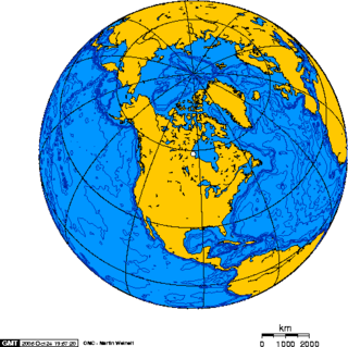
North America is the third largest continent, and is also a portion of the third largest supercontinent if North and South America are combined into the Americas and Africa, Europe, and Asia are considered to be part of one supercontinent called Afro-Eurasia. With an estimated population of 580 million and an area of 24,709,000 km2 (9,540,000 mi2), the northernmost of the two continents of the Western Hemisphere is bounded by the Pacific Ocean on the west; the Atlantic Ocean on the east; the Caribbean Sea on the south; and the Arctic Ocean on the north.

The Atlantic Plain is one of eight distinct physiographic divisions of the contiguous United States. Using the USGS physiographic classification system, the Atlantic Plain division comprises two provinces and six sections. The Coastal Plain province is differentiated from the Continental Shelf province simply based on the portion of the land mass above and below sea level.
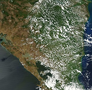
The Western Coastal Plains is a strip of coastal plain 50 kilometres in width between the west coast of India and the Western Ghats hills, which starts near the south of the Tapi River. The plains are located between the Western Ghats and the Arabian Sea. The plains begin at Gujarat in the north and end at Kanyakumari in Tamil Nadu, the southern tip of peninsular India. It includes the states of Gujarat, Maharashtra, Goa, Karnataka, Kerala, and a small part of Tamil Nadu. The region consists of three sections: the northern part of the coast is called the Konkan, the central stretch is called the Kanara or the "Karavali", while the southern stretch is referred to as the Malabar Coast. On its northern side there are two gulfs: the Gulf of Khambat and the Gulf of Kutch. The rivers along the coast form estuaries and provide conditions ideal for pisciculture. Because of the presence of less coastal land in this part, it will be affected more by the global warming.

The Geography of South India comprises the diverse topological and climatic patterns of South India. South India is a peninsula in the shape of a vast inverted triangle, bounded on the west by the Arabian Sea, on the east by the Bay of Bengal and on the north by the Vindhya and Satpura ranges.

Odisha is one of the 28 states in the Republic of India. Odisha is located in the eastern part of the Indian peninsula and the Bay of Bengal lies to its East while Chhattisgarh shares its border in the west and north-west. The state also shares geographic boundaries with West Bengal in the north-east, Jharkhand in the north and Andhra Pradesh in the south. The state is spread over an area of 1,55,707 km2 and extends for 700 km from north to south and 500 kilometres from east to west. Its coastline is 450 km long. The state is divided into 30 districts which are further subdivided into 317 blocks called tahasil.

The Indian city of Thiruvananthapuram is located in Thiruvananthapuram district in the state of Kerala. The city is located at 8.5°N 76.9°E on the west coast, near the southern tip of mainland India. The city situated on the west coast of India, and is bounded by Arabian Sea to its west and the Western Ghats to its east. The city and the suburbs spans an area of 250 km2 (96.53 sq mi). The average elevation of the city is 16 ft above sea level. The highest point within the city limits is the observatory. Agastya Mala, which has an elevation of 1,868 metres (6,129 ft) is only about 60 km from the city. The Ponmudi hill station which has an elevation of 1,100 metres (3,609 ft) is also near the city.

The Malabar Coast is the southwestern region of the Indian subcontinent. It generally refers to the western coastline of India stretching from Konkan to Kanyakumari. Geographically, it comprises one of the wettest regions of the subcontinent, which includes the Kanara region of Karnataka and all of Kerala.

Biogeographic classification of India is the division of India according to biogeographic characteristics. Biogeography is the study of the distribution of species (biology), organisms, and ecosystems in geographic space and through geological time. India has a rich heritage of natural diversity. India ranks fourth in Asia and tenth in the world amongst the top 17 mega-diverse countries in the world. India harbours nearly 11% of the world's floral diversity comprising over 17500 documented flowering plants, 6200 endemic species, 7500 medicinal plants and 246 globally threatened species in only 2.4% of world's land area. India is also home to four biodiversity hotspots—Andaman & Nicobar Islands, Eastern Himalaya, Indo-Burma region, and the Western Ghats. Hence the importance of biogeographical study of India's natural heritage.


