Hapua

Last updated
Coastal lagoon at the mouth of the Rakaia river, Canterbury Plains Rakaia River mouth, NZ.jpg
Coastal lagoon at the mouth of the Rakaia river, Canterbury Plains

A hapua is a river-mouth lagoon on a mixed sand and gravel (MSG) beach, formed at the river-coast interface where a typically braided, although sometimes meandering, river interacts with a coastal environment that is significantly affected by longshore drift. [1] The lagoons which form on the MSG coastlines are common on the east coast of the South Island of New Zealand and have long been referred to as hapua by Māori people. This classification differentiates hapua from similar lagoons located on the New Zealand coast termed waituna.

Contents

Hapua are often located on paraglacial coastal areas [2] where there is a low level of coastal development and minimal population density. Hapua form as the river carves out an elongated coast-parallel area, blocked from the sea by a MSG barrier which constantly alters its shape and volume due to longshore drift. [1] [3] Longshore drift continually extends the barrier behind which the hapua forms by transporting sediment along the coast. Hapua are defined as a narrow shore-parallel extensions of the coastal riverbed. [3] They discharge the majority of stored water to the ocean via an ephemeral and highly mobile drainage channel or outlet. [4] The remainder percolates through the MSG barrier due to its high levels of permeability. Hapua systems are driven by a wide range of dynamic processes that are generally classified as fluvial or marine; changes in the balance between these processes as well as the antecedent barrier conditions can cause shifts in the morphology of the hapua, in particular the barrier. New Zealand examples include the Rakaia, Ashburton and Hurunui river-mouths.

Hapua environment

Hapua have been identified as establishing in the Canterbury Bight coastal region on the east coast of the South Island. They are often found in areas of coarse-grained sediment where contributing rivers have moderately steep bed gradients. [1] MSG beaches in the Canterbury Bight region contain a wide range of sediment sizes from sand to boulders [5] and are exposed to the high energy waves that make up an east coast swell environment. [6] MSG beaches are reflective rather than dissipative energy zones due to their morphological characteristics. They have a steep foreshore which is known as the ‘engine room’ of the beach profile. In this zone, swash and backwash are dominating processes alongside longshore transport. [7] MSG beaches do not have a surf zone; instead a single line of breakers is visible in all sea conditions. [1] Hapua are associated with MSG beaches as the variation in sediment size allows for the barrier to be permeable.

The east coast of the South Island has been identified as being in a period of chronic erosion of approximately 0.5 metres per year. [8] This erosion trend is a result of a number of factors. According to the classification scheme of Zenkovich, [2] the rivers on the east coast can be described as ‘small’; this classification is not related to their flow rate but to the insufficient amount of sediment that they transport to the coast to nourish it. The sediment provided is not adequate to nourish the coast against its typical high energy waves and strong longshore drift. These two processes constantly remove sediment depositing it either offshore or further up drift. [9] As the coastline becomes eroded the hapua have been 'rolling back' by eroding the backshore to move landwards. [3]

Hapua or river-mouth lagoons form in micro-tidal environments. A micro-tidal environment is where the tidal range (distance between low tide and high tide) is less than two metres. [1] Tidal currents in a micro-tidal zone are less than those found on meso-tidal (two – four metres) and macro-tidal (greater than four metres) coastlines. [10] Hapua form in this type of tidal environment as the tidal currents are unable to compete with the powerful freshwater flows of the rivers therefore there is no negligible tidal penetration to the lagoon. [1] A fourth element of the environment in which hapua form is the strong longshore drift component. [1] Longshore or littoral drift is the transportation of sediments along the coast at an angle to the shoreline. In the Canterbury Bight coastal area; the dominant swell direction is northwards from the Southern Ocean. [1] Therefore, the principal movement of sediment via longshore drift is north towards Banks Peninsula. Hapua are located in areas dominated by longshore drift; because it aids the formation of the barrier behind which the hapua is sited.

A hapua also requires sediment to form the lagoon barrier. Sediment which nourishes the east coast of New Zealand can be sourced from three different areas. Material from the highly erodible Southern Alps is removed via weathering; then carried across the Canterbury Plains by various braided rivers to the east coast beaches. [3] [9] The second source of sediment is the high cliffs which are located in the hinterland of lagoons. [9] These can be eroded during the occurrence of high river flow or sea storm events. Beaches further south provide nourishment to the northern coast via longshore transport.

Hapua characteristics

Hapua have a number of characteristics which includes shifts between a variety of morphodynamic states due to changes in the balance between marine and fluvial processes as well as the antecedent barrier conditions. [3] The MSG barrier constantly changes size and shape as a result of the longshore drift. Water stored in the hapua drains to the coast predominantly though an outlet; although it can also seep through the barrier depending on the permeability of the material. [3] [11]

Changes in the level of the lagoon water do not occur as a result of saltwater or tidal intrusion. Water in a hapua is predominantly freshwater originating from the associated river. Hapua are non-estuarine, there is no tidal inflow however the tide does have an effect on the level of water in the lagoon. As the tide reaches its peak, the lagoon water has a much smaller amount of barrier to permeate through so the lagoon level rises. [12] This is related to a physics theory known as hydraulic head. The lagoon level has a similar sinusoidal wave shape as the tide but reaches its peak slightly later. [11] In general, any saltwater intrusion into the hapua will only occur during a storm via wave overtopping or sea spray. [3] [9]

Hapua can act as both a source and sink of sediment. [8] [9] The majority of sediment in the hapua is fluvial sourced. [1] During medium to low river flows, coarser sediment generally collects in the hapua; while some of the finer sediment can be transported through the outlet to the coast. [9] During flood events the hapua is 'flushed out' with larger amounts of sediment transferred through the outlet. This sediment can be deposited offshore or downdrift of the hapua replenishing the undernourished beach. [9] If a large amount of material is released to the coast at one time it can be identified as a 'slug'. These can often be visible from aerial photographs.

Antecedent barrier conditions combined with changes in the balance between marine and fluvial processes results in shifts between a variety of morphological states in a hapua or river-mouth lagoon on a MSG beach. Marine processes includes the direction of wave approach, wave height and the coincidence of storm waves with high tides. [13] Marine processes tend to dominate the majority of morphodynamic conditions until there is a large enough flood event in the associated river to breach the barrier. [1] The level and frequency of base or flood flows are attributed to fluvial processes. Antecedent barrier conditions are the permeability, volume and height of the barrier as well as the width and presence of previous outlet channels. [13] During low to medium river flows, the outlet from the lagoon to the sea becomes offset in the direction of longshore drift. [9] Outlet efficiency tends to decrease the further away from the main river-mouth the outlet is. [3] A decrease in efficiency can cause the outlet to become choked with sediment and the hapua to close temporarily. The potential for closure varies between different hapua depending on whether marine or fluvial processes are the bigger driver in the event. A high flow event; such as a fresh or flood can breach the barrier directly opposite the main river channel. [3] [9] This causes an immediate decrease in the water level of the hapua; as well as transporting previously deposited sediments into the ocean. Flood events are important for eroding lagoon back shores; this is a behaviour which allows hapua to retreat landward and thus remain coastal landforms even with coastal transgression and sea level rise. [3] During high flow events there is also the possibility for secondary breaches of the barrier or lagoon truncation to occur.

Storm events also have the ability to close hapua outlets as waves overtop the barrier depositing sediment and choking the scoured channel. [8] The resultant swift increase in lagoon water level causes a new outlet to be breached rapidly due to the large hydraulic head that forms between the lagoon and sea water levels. Storm breaching is believed to be an important but unpredictable control on the duration of closures at low to moderate river flow levels in smaller hapua. [8]

Hapua are extremely important for a number of reasons. They provide a link between the river and sea for migrating fish as well as a corridor for migratory birds. [1] [14] To lose this link via closure of the hapua outlet could result in losing entire generations of specific species as they may need to migrate to the ocean or the river as a vital part of their lifecycle. River-mouth lagoons such as hapua were also used a source for mahinga kai (food gathering) by the Māori people. [1] [14] However, this is no longer the case due to catchment degradation which has resulted in lagoon deterioration. River-mouth lagoons on MSG beaches are not well explained in international literature.

Hapua case study

The hapua located at the mouth of the Rakaia River stretches approximately three kilometres north from where the river-mouth reaches the coast. The average width of the hapua between 1952 and 2004 was approximately 50 metres; whilst the surface area has stabilised at approximately 600,000 square metres since 1966. [15] The coastal hinterland is composed of erodible cliffs and a low-lying area commonly known as the Rakaia Huts. This area has changed notably since European Settlement; with the drainage of ecologically significant wetlands and development of the small bach community.

The Rakaia River begins in the Southern Alps, providing approximately 4.2 Mt per year of sediment to the east coast. It is a braided river with a catchment area of 3105 kilometres squared and a mean flow of 221 cubic metres per second. [16] The mouth of the Rakaia River reaches the coast south-west of Banks Peninsula. As the river reaches the coast it diverges into two channels; with the main channel flowing to the south of the island. [8] As the hapua is located in the Canterbury Bight it is in a state of constant morphological change due to the prevailing southerly sea swells and resultant northwards longshore drift.

Related Research Articles

<span class="mw-page-title-main">Beach</span> Area of loose particles at the edge of the sea or other body of water

A beach is a landform alongside a body of water which consists of loose particles. The particles composing a beach are typically made from rock, such as sand, gravel, shingle, pebbles, etc., or biological sources, such as mollusc shells or coralline algae. Sediments settle in different densities and structures, depending on the local wave action and weather, creating different textures, colors and gradients or layers of material.

<span class="mw-page-title-main">Lagoon</span> Shallow body of water separated from a larger one by a narrow landform

A lagoon is a shallow body of water separated from a larger body of water by a narrow landform, such as reefs, barrier islands, barrier peninsulas, or isthmuses. Lagoons are commonly divided into coastal lagoons and atoll lagoons. They have also been identified as occurring on mixed-sand and gravel coastlines. There is an overlap between bodies of water classified as coastal lagoons and bodies of water classified as estuaries. Lagoons are common coastal features around many parts of the world.

<span class="mw-page-title-main">Shoal</span> Natural submerged sandbank that rises from a body of water to near the surface

In oceanography, geomorphology, and geoscience, a shoal is a natural submerged ridge, bank, or bar that consists of, or is covered by, sand or other unconsolidated material, and rises from the bed of a body of water close to the surface or above it, which poses a danger to navigation. Shoals are also known as sandbanks, sandbars, or gravelbars. Two or more shoals that are either separated by shared troughs or interconnected by past or present sedimentary and hydrographic processes are referred to as a shoal complex.

<span class="mw-page-title-main">Spit (landform)</span> Coastal bar or beach landform deposited by longshore drift

A spit or sandspit is a deposition bar or beach landform off coasts or lake shores. It develops in places where re-entrance occurs, such as at a cove's headlands, by the process of longshore drift by longshore currents. The drift occurs due to waves meeting the beach at an oblique angle, moving sediment down the beach in a zigzag pattern. This is complemented by longshore currents, which further transport sediment through the water alongside the beach. These currents are caused by the same waves that cause the drift.

<span class="mw-page-title-main">Longshore drift</span> Sediment moved by the longshore current

Longshore drift from longshore current is a geological process that consists of the transportation of sediments along a coast parallel to the shoreline, which is dependent on the angle of incoming wave direction. Oblique incoming wind squeezes water along the coast, and so generates a water current which moves parallel to the coast. Longshore drift is simply the sediment moved by the longshore current. This current and sediment movement occur within the surf zone. The process is also known as littoral drift.

<span class="mw-page-title-main">Barrier island</span> Coastal dune landform that forms by wave and tidal action parallel to the mainland coast

Barrier islands are a coastal landform—a type of dune system and sand island—where an area of sand has been formed by wave and tidal action parallel to the mainland coast. They usually occur in chains, consisting of anything from a few islands to more than a dozen. They are subject to change during storms and other action, but absorb energy and protect the coastlines and create areas of protected waters where wetlands may flourish. A barrier chain may extend for hundreds of kilometers, with islands periodically separated by tidal inlets. The largest barrier island in the world is Padre Island of Texas, United States, at 113 miles (182 km) long. Sometimes an important inlet may close permanently, transforming an island into a peninsula, thus creating a barrier peninsula, often including a beach, barrier beach. Though many are long and narrow, the length and width of barriers and overall morphology of barrier coasts are related to parameters including tidal range, wave energy, sediment supply, sea-level trends, and basement controls. The amount of vegetation on the barrier has a large impact on the height and evolution of the island.

<span class="mw-page-title-main">Groyne</span> Structure extending into a body of water to alter water flow

A groyne is a rigid hydraulic structure built perpendicularly from an ocean shore or a river bank, interrupting water flow and limiting the movement of sediment. It is usually made out of wood, concrete, or stone. In the ocean, groynes create beaches, prevent beach erosion caused by longshore drift where this is the dominant process and facilitate beach nourishment. There is also often cross-shore movement which if longer than the groyne will limit its effectiveness. In a river, groynes slow down the process of erosion and prevent ice-jamming, which in turn aids navigation.

<span class="mw-page-title-main">Lake Ellesmere / Te Waihora</span> Lagoon in New Zealand

Lake Ellesmere / Te Waihora is a broad, shallow coastal lake or waituna, in the Canterbury region of the South Island of New Zealand. It is directly to the west of Banks Peninsula, separated from the Pacific Ocean by the long, narrow, sandy Kaitorete Spit, or more correctly Kaitorete Barrier. It lies partially in extreme southeastern Selwyn District and partially in the southwestern extension of the former Banks Peninsula District, which now is a ward in the city of Christchurch. The lake holds high historical and cultural significance to the indigenous Māori population and the traditional Māori name Te Waihora, means spreading waters. It has officially had a dual English/Māori name since at least 1938.

<span class="mw-page-title-main">Coastal geography</span> Study of the region between the ocean and the land

Coastal geography is the study of the constantly changing region between the ocean and the land, incorporating both the physical geography and the human geography of the coast. It includes understanding coastal weathering processes, particularly wave action, sediment movement and weather, and the ways in which humans interact with the coast.

<span class="mw-page-title-main">Swash</span> A turbulent layer of water that washes up on the beach after an incoming wave has broken

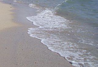
Swash, or forewash in geography, is a turbulent layer of water that washes up on the beach after an incoming wave has broken. The swash action can move beach materials up and down the beach, which results in the cross-shore sediment exchange. The time-scale of swash motion varies from seconds to minutes depending on the type of beach. Greater swash generally occurs on flatter beaches. The swash motion plays the primary role in the formation of morphological features and their changes in the swash zone. The swash action also plays an important role as one of the instantaneous processes in wider coastal morphodynamics.

<span class="mw-page-title-main">Kaitorete Spit</span> Spit in New Zealand

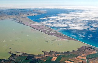
Kaitorete Spit is a long finger of land which extends along the coast of Canterbury in the South Island of New Zealand. It runs west from Banks Peninsula for 25 kilometres, and separates the shallow Lake Ellesmere / Te Waihora from the Pacific Ocean. It is technically a continuous barrier beach, though at its western end it tapers to a point less than 100 metres in width which is occasionally breached at high tide. The spit is noted for its isolation and for its pebbly beaches. At its eastern end is the small settlement of Birdlings Flat, and west of its narrowest point is the settlement of Taumutu.

<span class="mw-page-title-main">Cuspate foreland</span> Geographical features found on coastlines and lakeshores

Cuspate forelands, also known as cuspate barriers or nesses in Britain, are geographical features found on coastlines and lakeshores that are created primarily by longshore drift. Formed by accretion and progradation of sand and shingle, they extend outwards from the shoreline in a triangular shape.

<span class="mw-page-title-main">Depositional environment</span> Processes associated with the deposition of a particular type of sediment

In geology, depositional environment or sedimentary environment describes the combination of physical, chemical, and biological processes associated with the deposition of a particular type of sediment and, therefore, the rock types that will be formed after lithification, if the sediment is preserved in the rock record. In most cases, the environments associated with particular rock types or associations of rock types can be matched to existing analogues. However, the further back in geological time sediments were deposited, the more likely that direct modern analogues are not available.

Beach evolution occurs at the shoreline where sea, lake or river water is eroding the land. Beaches exist where sand accumulated from centuries-old, recurrent processes that erode rocky and sedimentary material into sand deposits. River deltas deposit silt from upriver, accreting at the river's outlet to extend lake or ocean shorelines. Catastrophic events such as tsunamis, hurricanes, and storm surges accelerate beach erosion.

<span class="mw-page-title-main">Sedimentary budget</span>

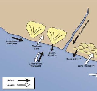
Sedimentary budgets are a coastal management tool used to analyze and describe the different sediment inputs (sources) and outputs (sinks) on the coasts, which is used to predict morphological change in any particular coastline over time. Within a coastal environment the rate of change of sediment is dependent on the amount of sediment brought into the system versus the amount of sediment that leaves the system. These inputs and outputs of sediment then equate to the total balance of the system and more than often reflect the amounts of erosion or accretion affecting the morphology of the coast.

Washdyke Lagoon is a brackish shallow coastal lagoon approximately 1 kilometre (0.62 mi) north of Timaru, South Canterbury, New Zealand. The lagoon has drastically reduced in size since 1881 when it was approximately 253 hectares, now it is less than 48 hectares (0.48 km2) in area. It is enclosed by a barrier beach that is 3 kilometres (1.9 mi) long and 3 metres (9.8 ft) above high tide at its largest point. The reduced lagoon size is due to the construction of the Timaru Port breakwater which is preventing coarse sediments from reaching and replenishing Washdyke Barrier. This is important as the lagoon and the surrounding 250 hectares are classified as a wildlife refuge and it demonstrates the role human structures have on coastline evolution.

<span class="mw-page-title-main">Lake Forsyth</span>

Lake Forsyth is a lake on the south-western side of Banks Peninsula in the Canterbury region of New Zealand, near the eastern end of the much larger Lake Ellesmere / Te Waihora. State Highway 75 to Akaroa and the Little River Rail Trail run along the north-western side of the lake.

<span class="mw-page-title-main">Canterbury Bight</span> Oceanic bight in Canterbury, New Zealand

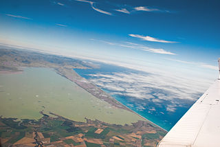
The Canterbury Bight is a large bight on the eastern side of New Zealand's South Island. The bight runs for approximately 135 kilometres (84 mi) from the southern end of Banks Peninsula to the settlement of Timaru and faces southeast, exposing it to high-energy storm waves originating in the Pacific Ocean. The bight is known for rough conditions as a result, with wave heights of over 2 metres (6.6 ft) common. Much of the bight's geography is shaped by this high-energy environment interacting with multiple large rivers which enter the Pacific in the bight, such as the Rakaia, Ashburton / Hakatere, and Rangitata Rivers. Sediment from these rivers, predominantly Greywacke, is deposited along the coast and extends up to 50 kilometres (31 mi) out to sea from the current shoreline. Multiple hapua, or river-mouth lagoons, can be found along the length of the bight where waves have deposited sufficient sediment to form a barrier across a river mouth, including most notably Lake Ellesmere / Te Waihora and Washdyke Lagoon

Coastal sediment supply is the transport of sediment to the beach environment by both fluvial and aeolian transport. While aeolian transport plays a role in the overall sedimentary budget for the coastal environment, it is paled in comparison to the fluvial supply which makes up 95% of sediment entering the ocean. When sediment reaches the coast it is then entrained by longshore drift and littoral cells until it is accreted upon the beach or dunes.

<span class="mw-page-title-main">Waituna</span> Type of freshwater coastal lagoon in New Zealand

A waituna is a freshwater coastal lagoon on a mixed sand and gravel (MSG) beach, formed where a braided river meets a coastline affected by longshore drift. This type of waterbody is neither a true lake, lagoon nor estuary.

References

  1. 1 2 3 4 5 6 7 8 9 10 11 12 Kirk, R.M. and Lauder, G.A. (2000). Significant coastal lagoon systems in the South Island, New Zealand: coastal processes and lagoon mouth closure. Department of Conservation.{{cite book}}: CS1 maint: multiple names: authors list (link)
  2. 1 2 Zenkovich, V.P. (1967). Processes of coastal development. Interscience Publishers.
  3. 1 2 3 4 5 6 7 8 9 10 Hart, D. E. (2009). "River mouth lagoon science and management". Beach Management, Principles and Practice. Earthscan Publications Ltd: 267, 280.
  4. “Paterson, A., Hume, T., & Healy, T. (2001). River mouth morphodynamics on a mixed sand-gravel coast. Journal of Coastal Research, 288–294.”
  5. “McLean, R. F. (1970). Variations in grain-size and sorting on two kaikoura beaches. New Zealand Journal of Marine and Freshwater Research, 4(2), 141–164.”
  6. “Davies, J. L. (1964). A morphogenic approach to world shorelines. Zeitschrift für Geomorphologie, 8, 127–142.”
  7. “Kirk, R. M. (1980). Mixed Sand and Gravel Beaches Morphology, Processes and Sediments. Progress in Physical Geography, 4(2), 189–210. doi:10.1177/030913338000400203”
  8. 1 2 3 4 5 Single, M. (2011). Lake Coleridge Project-Coastal processes at Rakaia River mouth (Report). Trust Power Ltd.
  9. 1 2 3 4 5 6 7 8 9 Kirk, R.M. (1991). "River-beach interaction on mixed sand and gravel coasts: a geomorphic model for water resource planning". Applied Geography. 11 (4): 267–287. doi:10.1016/0143-6228(91)90018-5.
  10. ”Short, A.D. (1991). Macro-Meso Tidal Beach Morphodynamics: An Overview. Journal of Coastal Research,417-436.”
  11. 1 2 Goring, D.G; Valentine, R.M. (1995). Tidal Hydraulics of a large, gravel-bed river mouth: the Rakaia hapua. 12th Australasian Coastal & Ocean Engineering Conference, combined with 5th Australasian Port & Harbour Conference, 1995.
  12. “Hume, T. M., & Herdendorf, C. E. (1988). A geomorphic classification of estuaries and its application to coastal resource management–A New-Zealand example. Ocean and Shoreline Management, 11(3), 249–274.”
  13. 1 2 Hart, D.E. and Bryan, K.R. (2008). "New Zealand coastal system boundaries, connections and management". New Zealand Geographer. 64 (2): 129–143. doi:10.1111/j.1745-7939.2008.00133.x.{{cite journal}}: CS1 maint: multiple names: authors list (link)
  14. 1 2 Single, M.B. and Hemmingson, M.A. (2001). "Mixed sand and gravel barrier beaches of South Canterbury, New Zealand". Ecology and Geomorphology of Coastal Shinge: 261–276.{{cite journal}}: CS1 maint: multiple names: authors list (link)
  15. "McHaffie, N. (n.d.). A GIS based analysis of changes in the Rakaia Hapua, Canterbury."
  16. "Hart, D. E. (2009). Morphodynamics of non-estuarine rivermouth lagoons on high-energy coasts. Journal of Coastal Research, SI 56 Proceedings of the 10th International Coastal Symposium."