Marine geology

Last updated

Marine geology or geological oceanography is the study of the history and structure of the ocean floor. It involves geophysical, geochemical, sedimentological and paleontological investigations of the ocean floor and coastal zone. Marine geology has strong ties to geophysics and to physical oceanography.

Contents

Marine geological studies were of extreme importance in providing the critical evidence for sea floor spreading and plate tectonics in the years following World War II. The deep ocean floor is the last essentially unexplored frontier and detailed mapping in support of economic (petroleum and metal mining), natural disaster mitigation, and academic objectives.

History

The study of marine geology dates back to the late 1800s during the 4-year HMS Challenger expedition. [1] [2] HMS Challenger hosted nearly 250 people, including sailors, engineers, carpenters, marines, officers, and a 6-person team of scientists, led by Charles Wyville Thomson. [1] [3] The scientists' goal was to prove that there was life in the deepest parts of the ocean. [3] Using a sounding rope, dropped over the edge of the ship, the team was able to capture ample amounts of data. Part of their discovery was that the deepest part of the ocean was not in the middle. [2] These were some of the first records of the mid-ocean ridge system.[ citation needed ]

Prior to World War II, marine geology grew as a scientific discipline. During the early 20th century, organizations such as the Scripps Institution of Oceanography and the Woods Hole Oceanographic Institution (WHOI) were created to support efforts in the field. [4] [5] With Scripps being located on the west coast of North America and WHOI on the east coast, the study of marine geology became much more accessible. [4] [5]

In the 1950s, marine geology had one of the most significant discoveries, the mid-ocean ridge system. After ships were equipped with sonar sensors, they travelled back and forth across the Atlantic Ocean collecting observations of the sea floor. [6] In 1953, the cartographer Marie Tharp generated the first three-dimensional relief map of the ocean floor which proved there was an underwater mountain range in the middle of the Atlantic, along with the Mid-Atlantic Ridge. [7] The survey data was large step towards many more discoveries about the geology of the sea. [6]

A theoretical model of the formation of magnetic striping. New oceanic crust forming continuously at the crest of the mid-ocean ridge cools and becomes increasingly older as it moves away from the ridge crest with seafloor spreading. Oceanic.Stripe.Magnetic.Anomalies.Scheme.svg
A theoretical model of the formation of magnetic striping. New oceanic crust forming continuously at the crest of the mid-ocean ridge cools and becomes increasingly older as it moves away from the ridge crest with seafloor spreading.

In 1960, the American geophysicist Harry H. Hess hypothesized that the seafloor was spreading from the mid-ocean ridge system. [6] With support from the maps of the sea floor, and the recently developed theory of plate tectonics and continental drift, Hess was able to prove that the Earth's mantle continuously released molten rock from the mid-ocean ridge and that the molten rock then solidified, causing the boundary between the two tectonic plates to diverge. [8] A geomagnetic survey was conducted that supported this theory. The survey was composed of scientists using magnetometers to measure the magnetism of the basalt rock protruding from the mid-ocean ridge. [6] [9] They discovered that on either side of the ridge, symmetrical "strips" were found as the polarity of the planet would change over time. [6] [9] This proved that seafloor spreading existed. In later years, newer technology was able to date the rocks and identified that rocks closest to the ridge were younger than the rocks near the coasts of the Western and Eastern Hemispheres land.

At present, marine geology focuses on geological hazards, environmental conditions, habitats, natural resources, and energy and mining projects. [10]

Methods

There are multiple methods for collecting data from the sea floor without physically dispatching humans or machines to the bottom of the ocean.

Side-scan sonar

A common method of collecting imagery of the sea floor is side-scan sonar. [11] [12] Developed in the late 1960s, the purpose of the survey method is to use active sonar systems on the sea floor to detect and develop images of objects. [11] The physical sensors of the sonar device are known as a transducer array and they are mounted onto the hull of a vessel which sends acoustic pulses that reflect off the seafloor and received by the sensors. The imaging can help determine the seafloors composition as harder objects generate a stronger reflectance and appear dark on the returned image. Softer materials such as sand and mud cannot reflect the arrays pulses as well so they appear lighter on the image. This information can be analyzed by specialist to determine outcrops of rock beneath the surface of the water. [12]

This method is less expensive than releasing a vehicle to take photographs of the sea floor, and requires less time. [12] The side-scan sonar is useful for scientists as it is a quick and efficient way of collecting imagery of the sea floor, but it cannot measure other factors, such as depth. [11] [12] Therefore, other depth measuring sonar devices are typically accompanied with the side-scan sonar to generate a more detailed survey. [11]

Multibeam bathymetry

Similarly to side-scan sonar, multibeam bathymetry uses a transducer array to send and receive sound waves in order to detect objects located on the sea floor. [13] Unlike side-scan sonar, scientists are able to determine multiple types of measurements from the recordings and make hypothesis' on the data collected. By understanding the speed at which sound will travel in the water, scientists can calculate the two way travel time from the ship's sensor to the seafloor and back to the ship. These calculations will determine to depth of the sea floor in that area. [13]

EM300 bathymetry of the three submarine volcanoes in the vicinity of Farallon de Pajaros Island. The data were collected using the EM300 multibeam system mounted on the hull of the R/V Thompson. The grid-cell size is 35 meters. The image is 2 times vertically exaggerated. Uracas 3d hires.jpg
EM300 bathymetry of the three submarine volcanoes in the vicinity of Farallon de Pajaros Island. The data were collected using the EM300 multibeam system mounted on the hull of the R/V Thompson. The grid-cell size is 35 meters. The image is 2 times vertically exaggerated.

Backscatter is another measurement used to determine the intensity of the sound that is returned to the sensor. [13] This information can provide insight on the geological makeup and objects of the sea floor as well as objects located within the water column. Objects in the water column can include structures from shipwrecks, dense biology, and bubble plumes. The importance of objects in the water column to marine geology is identifying specific features as bubble plumes can indicate the presence of hydrothermal vents and cold seeps. [13]

There are limitations to this technique. The distance between the sea floor and the sensor is related to the resolution of the map being created. [13] The closer the sensor is the sea floor, the higher the resolution will be and the farther away the sensor is to the sea floor, the lower the resolution will be. Therefore, it is common for remotely operated vehicles (ROVs) and autonomous underwater vehicles (AUVs) to be equipped with the multibeam sensor or for the sensor to be towed by the ship its self. This ensures that the resolution of the collected data will be high enough for proper analysis. [13]

Sub-bottom profiler

A sub-bottom profiler is another sonar system used in geophysical surveys of the sea floor to not only map depth, but also to map beneath the sea floor. [14] Mounted to the hull of a ship, the system releases low-frequency pulses which penetrate the surface of the sea floor and are reflected by sediments in the sub-surface. Some sensors can reach over 1000 meters below the surface of the sea floor, giving hydrographers a detailed view of the marine geological environment. [2]

Many sub-bottom profilers can emit multiple frequencies of sound to record data on a multitude of sediments and objects on and below the sea floor. The returned data is collected by computers and with aid from hydrographers, can create cross-sections of the terrain below the sea floor. [14] The resolution of the data also allows scientists to identify geological features such as volcanic ridges, underwater landslides, ancient river beds, and other features. [14]

The benefit of the sub-bottom profiler is its capability to record information on the surface and below the seafloor. When accompanied with geophysical data from multibeam sonar and physical data from rock and core samples, the sub-bottom profiles delivers insights on the location and morphology of submarine landslide, identifies how oceanic gasses travel through the subsurface, discover artifacts from cultural heritages, understand sediment deposition, and more. [14]

Marine magnetometry

A magnetometer used by the United States Navy in 2004. Magnetometer2004USNavy.jpg
A magnetometer used by the United States Navy in 2004.

Magnetometry is the process of measuring changes in the Earth's magnetic field. [15] The outer layer of the Earth's core is liquid and mostly made up of magnetic iron and nickel. [16] When the Earth turns on its axis, the metals release electrical currents which generate magnetic fields. [17] These fields can then be measured to reveal geological subseafloor structures. [18] This method is especially useful in marine exploration and geology as it can not only characterize geological features on the seafloor but can survey aircraft and ship wrecks deep under the sea. [19]

A magnetometer is the main piece of equipment deployed, which is typically towed behind a vessel or mounted to a AUV. It is able to measure the changes in fields of magnetism and corresponding geolocation to create maps. [20] The magnetometer evaluates the magnetic presence generally every second, or one hertz, but can be calibrated to measure at different speeds depending on the study. The readings will be consistent until the device detects ferrous material. [21] This could range from a ship's hull to ferrous basalt at the seafloor. The sudden change in magnetism can be analyzed on the magnetometer's display. [22]

The benefit to a magnetometer compared to sonar devices is its ability to detect artifacts and geological features on top and underneath the seafloor. [23] [24] Because the magnetometer is a passive sensor, and does not emit waves, its exploration depth is unlimited. [25] Although, in most studies, the resolution and certainty of the data collected is dependent on the distance from the device. The closer the device is to a ferrous object, the better the data collected.

Plate tectonics

Map of Earth's principal tectonic plates. Tectonic plates (2022).svg
Map of Earth's principal tectonic plates.

Plate tectonics is a scientific theory developed in the 1960s that explains major land form events, such as mountain building, volcanoes, earthquakes, and mid-ocean ridge systems. [26] The idea is that Earth's most outer layer, known as the lithosphere, that is made up of the crust and mantle is divided into extensive plates of rock. [8] [26] These plates sit on top of partially molten layer of rock know as the asthenosphere and move relative to each other due to convection between the asthenosphere and lithosphere. [26] The speed at which the plates move ranges between 2 and 15 centimeters per year. Why this theory is so significant is the interaction between the tectonic plates explains many geological formations. [8] In regards to marine geology, the movement of the plates explains seafloor spreading and mid-ocean ridge systems, subduction zones and trenches, volcanism and hydrothermal vents, and more.

There are three major types of tectonic plate boundaries; divergent, convergent, and transform boundaries. [27] Divergent plate boundaries are when two tectonic plates move away from each other, convergent plate boundaries are when two plates move towards each other, and transform plate boundaries are when two plates slide sideways past each other. Each boundary type is associated with different geological marine features. Divergent plates are the cause for mid-ocean ridge systems while convergent plates are responsible for subduction zones and the creation of deep ocean trenches. Transform boundaries cause earthquakes, displacement of rock, and crustal deformation. [8] [27] [26] [28]

Mid-ocean ridge system

Divergent plates are directly responsible for the largest mountain range on Earth, known as the mid-ocean ridge system. [29] At nearly 60,000 km long, the mid-ocean ridge is an extensive chain of underwater volcanic mountains that spans the globe. [30] Centralized in the oceans, this unique geological formation houses a collection of ridges, rifts, fault zones, and other geological features. [29] [30]

The Mid-Atlantic Ridge is a consequence of the diverging North American and Eurasian, and the African and South American Plates. [31] It began forming over 200 million years ago when the American, African and European continents were still connected, forming the Pangea. [32] After continental drift, the ridge system became more defined and in the last 75 years, it has been intensely studied. The Mid-Atlantic Ridge was also served as the birthplace for the discovery of seafloor spreading. [33] As volcanic activity produces new oceanic crust along the ridge, the two plates diverge from each other pulling up the new ocean floor from below the crust. [31] [32] [33] Along the ocean-continent border of the tectonic plates, the oceanic plates subduct underneath the continental plates, creating some of the deepest marine trenches in the world

Diagram of the geological process of subduction. Subduction-en.svg
Diagram of the geological process of subduction.

Subduction zones

Subduction zones are caused when two tectonic plates converge on each other and one plate is pushed beneath the other. [34] In a marine setting, this typically occurs when the oceanic crust subducts below the continental crust, resulting in volcanic activity and the development of deep ocean trenches. [35] Marine geology focuses on mapping and understanding how these processes function. Renowned geological features created through subduction zones include the Mariana Trench and the Ring of Fire. [36] [37]

Mariana Trench

The Mariana Trench is the deepest known submarine trench, and the deepest location in the Earth's crust itself. [38] It is a subduction zone where the Pacific Plate is being subducted under the Mariana Plate. [3] At the deepest point, the trench is nearly 11,000 m deep (almost 36,000 feet). [38] [3] This is further below sea level than Mount Everest is above sea level, by over 2 kilometers.

Volcanic arcs and oceanic trenches partly encircling the Pacific Basin form the so-called Pacific Ring of fire, a zone of frequent earthquakes and volcanic eruptions. Pacific Ring of Fire.svg
Volcanic arcs and oceanic trenches partly encircling the Pacific Basin form the so-called Pacific Ring of fire, a zone of frequent earthquakes and volcanic eruptions.

Ring of Fire

The Ring of Fire is situated around the Pacific Ocean, created from several converging plate boundaries. [39] Its intense volcanism and seismic activity poses a major threat for disastrous earthquakes, tsunamis, and volcanic eruptions. [40] Any early warning systems and mitigation techniques for these disastrous events will require marine geology of coastal and island arc environments to predict events. [41]

Economic benefits

Resource exploration

Marine geology has several methods of detecting geological features below the sea. [2] [13] [14] [15] One of the economic benefits of geological surveying of the seafloor is determining valuable resources that can be extracted. [42] The two major resources mined at sea include oil and minerals. Over the last 30 years, deep-sea mining has generated between $9 -$11 billion USD in the United States of America. [43] [44] Although this sector seems profitable, it is a high risk, high reward industry with many harmful environmental impacts. [45]

Some of the major minerals extracted from the sea include nickel, copper, cobalt, manganese, zinc, gold, and other metals. [46] These minerals are commonly formed around volcanic activity, more specifically hydrothermal vents and polymetallic nodules. [47] [48] These vents emit large volumes of super-heated, metal infused fluids that rise and rapidly cool when mixed with the cold seawater. The chemical reaction causes sulfur and minerals to precipitate and from chimneys, towers, and mineral-rich deposits on the sea floor. [49] Polymetallic nodules, also known as manganese nodules, are rounded ores formed over millions of years from precipitating metals from seawater and sediment pore water. [50] They are typically found unattached, spread across the abyssal seafloor and contain metals crucial for building batteries and touch screens, including cobalt, nickel, copper, and manganese. [50]

Manganese nodules on the seafloor in the Clarion-Clipperton zone. The image was taken with ROV KIEL 6000 during expedition SO239 with FS SONNE in April 2015. 2015-04-14 18-20-14 Sonne SO239 157ROV11 Logo original(1).jpg
Manganese nodules on the seafloor in the Clarion-Clipperton zone. The image was taken with ROV KIEL 6000 during expedition SO239 with FS SONNE in April 2015.

A popular area for deep-sea mining, located in the Pacific Ocean, in the Clarion-Clipperton Zone (CCZ). The CCZ is approximately 4,500,000 square kilometers constructed of various submarine fracture zones. [51] It has been divided into 16 mining claims and 9 sections dedicated to conservation. [52] According to the International Seabed Authority (ISA), there is an estimated 21 billion tons (Bt) of nodules; 5.95 Bt of manganese, 0.27 Bt of nickel, 0.23 Bt of copper, and 0.05 Bt of cobalt. It is a highly sought-after area for mining because of the yield of minerals it posses. [53] [54]

Offshore energy development

Marine geology also has many applications on the subject of offshore energy development. [55] Offshore energy is the generation of electricity using ocean-based resources. This includes using wind, thermal [ clarification needed ], wave, and tidal movement to convert to energy. [56] Understanding the seafloor and geological features can help develop the infrastructure to support these renewable energy sources. [57] Underwater geological features can dictate ocean properties, such as currents and temperatures, which are crucial for location placement of the necessary infrastructure to produce energy. [58]

The stability of the seafloor is important for the creation of offshore wind turbines. [59] Most turbines are secured to the seafloor using monopiles, if the water depth is greater than 15 meters. [60] There must be inserted in areas that are not at risk to sediment deposition, erosion, or tectonic activity. Surveying the geological area before development is needed to insure proper support of the turbines and forces applied to them. [60] Another example why marine geology is needed for future energy projects is to understand wave and current patterns. [61] Analyzing the effects that the seafloor has on water movement can help support planning and location selection of generators offshore and optimize energy farming. [62]

Environmental impacts and mitigation

Habitat mapping and conservation

Marine geology has a key role in habitat mapping and conservation. With global events causing potentially irreversible damage to the sea habitats, such as deep-sea mining and bottom trawling, marine geology can help us study and mitigate the affects of these activity. [63]

The CCZ has been surveyed and mapped to designate specific areas for mining and for conservation. The International Seabed Authority has set aside approximately 160,000 square kilometers of seabed within the CCZ as the area is rich with biodiversity and habitats. [51] The zone houses over 5,000 species, including sea cucumbers, corals, crabs, shrimps, glass sponges, and members of the spider family and, has been an area where new species of sea worms have been discovered. [53] Furthermore, 90% of the species have yet to be identified. [64] Proper marine survey techniques have protected thousands of habitats and species by dedicating it to conservation.

Bottom trawling also poses a detrimental effects to the sea and using marine geology techniques can be helpful at mitigating them. [65] Bottom trawling, generally a commercial fishing technique, involves dragging a large net that herds and captures a target species, such as fish or crabs. [66] During this process, the net damages the seafloor by scraping and removing animals and vegetation living on the seabed, including coral reefs, sharks, and sea turtles. [67] It can tear up root systems and animal burrows, which can directly affect the sediment distribution. [68] This can lead to the change in chemistry and nutriment levels in the sea water. [69] Marine geology can determine areas which have been damaged to employ habitat restoration techniques. It can also help determine areas that have not been affecting by bottom trawling and employ conservation protection.

Sediment transportation and coastal erosion

Sediment transportation and coastal erosion is a complex subject that is necessary to understand to protect infrastructure and the environment. [70] Coastal erosion is the process of sediment and materials breaking down and transported due to the effects of the sea. [71] This can lead to destruction animal habitats, fishing industries, and infrastructure. [72] In the United States, damages to properties and infrastructure has caused approximately $500 million per year, and an additional $150 million a year is dedicated to mitigation from the U.S. federal government. [73] Marine geology supports the study of sediment types, current patterns, and ocean topography to predict erosional trends which can protect these environments. [74]

Natural hazard assessment

Model of the earthquake epicenter and tsunami extent of the 2004 Indian Ocean earthquake 2004 Indonesia Tsunami Complete.gif
Model of the earthquake epicenter and tsunami extent of the 2004 Indian Ocean earthquake

Earthquakes are one of the most common natural disasters. [75] Furthermore, they can cause other disasters, such as tsunamis and landslides, such as the underwater earthquake in the Indian Ocean occurred at a magnitude of 9.1 which then triggered a tsunami that caused waves to reach a height of at least 30 ft and killed approximately 230,000 people in 13 different countries. [76] [77] Marine geology and understanding plate boundaries supports the development of early warning systems and other mitigation techniques to protect the people and environments who may be susceptible to natural disasters. [78] Many earthquake early warning systems (EEWS) are in place and more are being developed. [79] [80]

Future research

Seafloor mapping and bathymetry

Many section of the oceans are permanently dark, low temperatures, and are under extreme pressure, making them difficult to observe. [81] According to the National Oceanic and Atmospheric Administration (NOAA), only 23% of the seafloor has been mapped in detail and one of the leading projects in exploration is developing high-resolution maps of the seafloor. The Okeanos Explorer , a vessel owned by NOAA, has already mapped over 2 million km2 of the seafloor using multibeam sonar since 2008, but this technique has proved to be too time-consuming. [82]

The importance of mapping the seafloor has been recognized by governments and scientists alike. Because of this, an international collaboration effort to create a high-definition map of the entire seafloor was developed, called the Nippon Foundation-GEBCO Seabed 2030 Project. This committee has a set goal to have the project finished by 2030. To reach their goal, they are equipping old, new, and autonomous vehicles with sonar, sensors, and other GIS based technology to reach their goal. [82]

See also

Related Research Articles

<span class="mw-page-title-main">Plate tectonics</span> Movement of Earths lithosphere

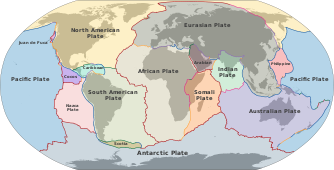
Plate tectonics is the scientific theory that Earth's lithosphere comprises a number of large tectonic plates, which have been slowly moving since about 3.4 billion years ago. The model builds on the concept of continental drift, an idea developed during the first decades of the 20th century. Plate tectonics came to be accepted by geoscientists after seafloor spreading was validated in the mid-to-late 1960s.

<span class="mw-page-title-main">Seafloor spreading</span> Geological process at mid-ocean ridges

Seafloor spreading, or seafloor spread, is a process that occurs at mid-ocean ridges, where new oceanic crust is formed through volcanic activity and then gradually moves away from the ridge.

<span class="mw-page-title-main">Mid-Atlantic Ridge</span> Atlantic Ocean tectonic plate boundary

The Mid-Atlantic Ridge is a mid-ocean ridge located along the floor of the Atlantic Ocean, and part of the longest mountain range in the world. In the North Atlantic, the ridge separates the North American from the Eurasian Plate and the African Plate, north and south of the Azores Triple Junction. In the South Atlantic, it separates the African and South American plates. The ridge extends from a junction with the Gakkel Ridge northeast of Greenland southward to the Bouvet Triple Junction in the South Atlantic. Although the Mid-Atlantic Ridge is mostly an underwater feature, portions of it have enough elevation to extend above sea level, for example in Iceland. The ridge has an average spreading rate of about 2.5 centimetres (1 in) per year.

<span class="mw-page-title-main">Seamount</span> Mountain rising from the ocean seafloor that does not reach to the waters surface

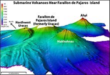
A seamount is a large submarine landform that rises from the ocean floor without reaching the water surface, and thus is not an island, islet, or cliff-rock. Seamounts are typically formed from extinct volcanoes that rise abruptly and are usually found rising from the seafloor to 1,000–4,000 m (3,300–13,100 ft) in height. They are defined by oceanographers as independent features that rise to at least 1,000 m (3,281 ft) above the seafloor, characteristically of conical form. The peaks are often found hundreds to thousands of meters below the surface, and are therefore considered to be within the deep sea. During their evolution over geologic time, the largest seamounts may reach the sea surface where wave action erodes the summit to form a flat surface. After they have subsided and sunk below the sea surface such flat-top seamounts are called "guyots" or "tablemounts".

<span class="mw-page-title-main">Transform fault</span> Plate boundary where the motion is predominantly horizontal

A transform fault or transform boundary, is a fault along a plate boundary where the motion is predominantly horizontal. It ends abruptly where it connects to another plate boundary, either another transform, a spreading ridge, or a subduction zone. A transform fault is a special case of a strike-slip fault that also forms a plate boundary.

<span class="mw-page-title-main">Abyssal plain</span> Flat area on the deep ocean floor

An abyssal plain is an underwater plain on the deep ocean floor, usually found at depths between 3,000 and 6,000 metres. Lying generally between the foot of a continental rise and a mid-ocean ridge, abyssal plains cover more than 50% of the Earth's surface. They are among the flattest, smoothest, and least explored regions on Earth. Abyssal plains are key geologic elements of oceanic basins.

<span class="mw-page-title-main">Oceanic crust</span> Uppermost layer of the oceanic portion of a tectonic plate

Oceanic crust is the uppermost layer of the oceanic portion of the tectonic plates. It is composed of the upper oceanic crust, with pillow lavas and a dike complex, and the lower oceanic crust, composed of troctolite, gabbro and ultramafic cumulates. The crust overlies the rigid uppermost layer of the mantle. The crust and the rigid upper mantle layer together constitute oceanic lithosphere.

<span class="mw-page-title-main">Seabed</span> The bottom of the ocean

The seabed is the bottom of the ocean. All floors of the ocean are known as 'seabeds'.

<span class="mw-page-title-main">Fracture zone</span> Linear feature on the ocean floor

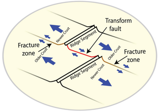
A fracture zone is a linear feature on the ocean floor—often hundreds, even thousands of kilometers long—resulting from the action of offset mid-ocean ridge axis segments. They are a consequence of plate tectonics. Lithospheric plates on either side of an active transform fault move in opposite directions; here, strike-slip activity occurs. Fracture zones extend past the transform faults, away from the ridge axis; are usually seismically inactive, although they can display evidence of transform fault activity, primarily in the different ages of the crust on opposite sides of the zone.

<span class="mw-page-title-main">Mid-ocean ridge</span> Basaltic underwater mountain system formed by plate tectonic spreading

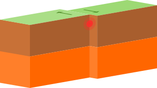
A mid-ocean ridge (MOR) is a seafloor mountain system formed by plate tectonics. It typically has a depth of about 2,600 meters (8,500 ft) and rises about 2,000 meters (6,600 ft) above the deepest portion of an ocean basin. This feature is where seafloor spreading takes place along a divergent plate boundary. The rate of seafloor spreading determines the morphology of the crest of the mid-ocean ridge and its width in an ocean basin.

<span class="mw-page-title-main">Back-arc basin</span> Submarine features associated with island arcs and subduction zones

A back-arc basin is a type of geologic basin, found at some convergent plate boundaries. Presently all back-arc basins are submarine features associated with island arcs and subduction zones, with many found in the western Pacific Ocean. Most of them result from tensional forces, caused by a process known as oceanic trench rollback, where a subduction zone moves towards the subducting plate. Back-arc basins were initially an unexpected phenomenon in plate tectonics, as convergent boundaries were expected to universally be zones of compression. However, in 1970, Dan Karig published a model of back-arc basins consistent with plate tectonics.

Ronald George Mason was one of the oceanographers whose pioneering Cold War geomagnetic survey work lead to the discovery of magnetic striping on the seafloor. First discovering magnetic stripes on the bottom of the Pacific Ocean off the United States West Coast, he later also identified them around the Mid-Atlantic Ridge.

<span class="mw-page-title-main">Gorringe Ridge</span> Seamount in the Atlantic Ocean on the Azores–Gibraltar fault zone

The Gorringe Ridge is a seamount in the Atlantic Ocean. It is located about 130 miles west of Portugal, between the Azores and the Strait of Gibraltar along the Azores–Gibraltar fault zone. It is about 60 kilometres wide and 180 kilometres long in the northeast direction. It is, since 2015, a marine protected area of Portugal included in the Natura 2000 program. If measured from the bottom of the Tagus Abyssal Plain, the ridge would measure more than 5,000 m (16,400 ft) in height, which would make it Portugal's highest mountain.

<span class="mw-page-title-main">Vine–Matthews–Morley hypothesis</span> First key scientific test of the seafloor spreading theory of continental drift and plate tectonics

The Vine–Matthews–Morley hypothesis, also known as the Morley–Vine–Matthews hypothesis, was the first key scientific test of the seafloor spreading theory of continental drift and plate tectonics. Its key impact was that it allowed the rates of plate motions at mid-ocean ridges to be computed. It states that the Earth's oceanic crust acts as a recorder of reversals in the geomagnetic field direction as seafloor spreading takes place.

<span class="mw-page-title-main">Mariana Plate</span> Small tectonic plate west of the Mariana Trench

The Mariana Plate is a micro tectonic plate located west of the Mariana Trench which forms the basement of the Mariana Islands which form part of the Izu–Bonin–Mariana Arc. It is separated from the Philippine Sea Plate to the west by a divergent boundary with numerous transform fault offsets. The boundary between the Mariana and the Pacific Plate to the east is a subduction zone with the Pacific Plate subducting beneath the Mariana. This eastern subduction is divided into the Mariana Trench, which forms the southeastern boundary, and the Izu–Ogasawara Trench the northeastern boundary. The subduction plate motion is responsible for the shape of the Mariana plate and back arc.

NOAAS <i>Okeanos Explorer</i> Exploratory vessel for the National Oceanic and Atmospheric Administration

NOAAS Okeanos Explorer is a converted United States Navy ship, now an exploratory vessel for the National Oceanic and Atmospheric Administration (NOAA), officially launched in 2010. Starting in 2010, NOAA entered into a five-year partnership with the San Francisco Exploratorium. The focus is on gathering scientific information about oceans for the public as well as for scientific uses. As much as 95% of the ocean remains unexplored, NOAA officials said. The ship is equipped with cameras and will provide real-time viewing of the ocean floor for scientists and for the public.

The Guaymas Basin is the largest marginal rift basin located in the Gulf of California. It made up of the northern and southern trough and is linked to the Guaymas Fault to the north and the Carmen Fault to the south. The mid-ocean ridge system is responsible for the creation of the Guaymas Basin and giving it many features such as hydrothermal circulation and hydrocarbon seeps. Hydrothermal circulation is a significant process in the Guaymas Basin because it recycles energy and nutrients which are instrumental in sustaining the basin's rich ecosystem. Additionally, hydrocarbons and other organic matter are needed to feed a variety of organisms, many of which have adapted to tolerate the basin's high temperatures.

<span class="mw-page-title-main">Project FAMOUS</span> Marine scientific exploration by manned submersibles of a diverging tectonic plate boundary

Project FAMOUS was the first-ever marine scientific exploration by manned submersibles of a diverging tectonic plate boundary on a mid-ocean ridge. It took place between 1971 and 1974, with a multi-national team of scientists concentrating numerous underwater surveys on an area of the Mid-Atlantic Ridge about 700 kilometers west of the Azores. By deploying new methods and specialized equipment, scientists were able to look at the sea floor in far greater detail than ever before. The project succeeded in defining the main mechanisms of creation of the median rift valley on the Mid-Atlantic Ridge, and in locating and mapping the zone of oceanic crustal accretion.

<span class="mw-page-title-main">Marine geophysics</span>

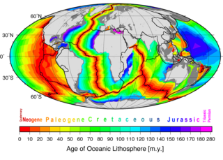
Marine geophysics is the scientific discipline that employs methods of geophysics to study the world's ocean basins and continental margins, particularly the solid earth beneath the ocean. It shares objectives with marine geology, which uses sedimentological, paleontological, and geochemical methods. Marine geophysical data analyses led to the theories of seafloor spreading and plate tectonics.

Suzanne Carbotte is a marine geophysicist known for her research on the formation of new oceanic crust.

References

  1. 1 2 Heckel, Jodi; Bureau, Illinois News (2023-02-10). "Exploring the deep with the HMS Challenger | College of Liberal Arts & Sciences at Illinois". las.illinois.edu. Retrieved 2024-02-19.
  2. 1 2 3 4 Board, National Research Council (US) Ocean Studies (2000), "Achievements in Marine Geology and Geophysics", 50 Years of Ocean Discovery: National Science Foundation 1950—2000, National Academies Press (US), retrieved 2024-02-19
  3. 1 2 3 4 "HMS Challenger Expedition | History of a Scientific Trailblazer". www.rmg.co.uk. Retrieved 2024-02-19.
  4. 1 2 "Who We Are - Woods Hole Oceanographic Institution". www.whoi.edu/. Retrieved 2024-02-19.
  5. 1 2 "About Scripps Oceanography". scripps.ucsd.edu. Retrieved 2024-02-19.
  6. 1 2 3 4 5 "Seafloor spreading | Evidence & Process | Britannica". www.britannica.com. Retrieved 2024-02-19.
  7. Blakemore, Erin (30 August 2016). "Seeing Is Believing: How Marie Tharp Changed Geology Forever". Smithsonian Magazine. Retrieved 2024-04-17.
  8. 1 2 3 4 "Plate Tectonics". education.nationalgeographic.org. Retrieved 2024-02-19.
  9. 1 2 "Seafloor Spreading". education.nationalgeographic.org. Retrieved 2024-02-19.
  10. "marine geology research: Topics by Science.gov". www.science.gov. Retrieved 2024-02-19.
  11. 1 2 3 4 Johnson, Paul; Helferty (1990). "The geological interpretation of side-scan sonar" (PDF). Reviews of Geophysics. 28 (4): 357–380. Bibcode:1990RvGeo..28..357J. doi:10.1029/RG028i004p00357.
  12. 1 2 3 4 "Exploration Tools: Side-Scan Sonar: NOAA Office of Ocean Exploration and Research". oceanexplorer.noaa.gov. Retrieved 2024-02-19.
  13. 1 2 3 4 5 6 7 "Exploration Tools: Multibeam Sonar: NOAA Office of Ocean Exploration and Research". oceanexplorer.noaa.gov. Retrieved 2024-02-19.
  14. 1 2 3 4 5 "Exploration Tools: Sub-Bottom Profiler: NOAA Office of Ocean Exploration and Research". oceanexplorer.noaa.gov. Retrieved 2024-02-19.
  15. 1 2 Zhang, Wentao; Huang, Wenzhu; Luo, Yingbo; Li, Fang (May 2019). "Simultaneous detection of deep-sea earthquake and magnetic field using three-axis fiber optic accelerometer-magnetometer". 2019 IEEE International Instrumentation and Measurement Technology Conference (I2MTC). IEEE. pp. 1–5. doi:10.1109/i2mtc.2019.8826972. ISBN   978-1-5386-3460-8.
  16. Loper, David E. (January 2000). "A model of the dynamical structure of Earth's outer core". Physics of the Earth and Planetary Interiors. 117 (1–4): 179–196. Bibcode:2000PEPI..117..179L. doi:10.1016/s0031-9201(99)00096-5. ISSN   0031-9201.
  17. "The Earth's Magnetic Field", The Earth’s Magnetism, Springer Berlin Heidelberg, pp. 1–66, 2006, doi:10.1007/978-3-540-27980-8_1, ISBN   978-3-540-27979-2 , retrieved 2024-04-11
  18. Hood, P J (1966). Geophysical reconnaissance of Hudson Bay Part I Sea-magnetometer Survey Part Ii Subbottom Depth Recorder Survey (Report). Natural Resources Canada/CMSS/Information Management. doi: 10.4095/100974 .
  19. Talwani, M. (October 1973). "Geomagnetism in marine geology". Marine Geology. 15 (3): 212–213. Bibcode:1973MGeol..15..212T. doi:10.1016/0025-3227(73)90069-8. ISSN   0025-3227.
  20. Kostenko, Vladimir V.; Tolstonogov, Anton Yu.; Mokeeva, Irina G. (April 2019). "The Combined AUV Motion Control with Towed Magnetometer". 2019 IEEE Underwater Technology (UT). IEEE. pp. 1–7. doi:10.1109/ut.2019.8734468. ISBN   978-1-5386-4188-0.
  21. "Exploration Tools: Magnetometer: NOAA Office of Ocean Exploration and Research". oceanexplorer.noaa.gov. Retrieved 2024-04-11.
  22. Robbes, D. (May 2006). "Highly sensitive magnetometers—a review". Sensors and Actuators A: Physical. 129 (1–2): 86–93. doi:10.1016/j.sna.2005.11.023. ISSN   0924-4247.
  23. Deans, Cameron; Marmugi, Luca; Renzoni, Ferruccio (2018-03-22). "Active underwater detection with an array of atomic magnetometers". Applied Optics. 57 (10): 2346–2351. arXiv: 1803.07846 . Bibcode:2018ApOpt..57.2346D. doi:10.1364/ao.57.002346. ISSN   1559-128X. PMID   29714214.
  24. Clausen, Carl J.; Arnold, J. Barto (May 1976). "The magnetometer and underwater archaeology". International Journal of Nautical Archaeology. 5 (2): 159–169. Bibcode:1976IJNAr...5..159C. doi:10.1111/j.1095-9270.1976.tb00953.x. ISSN   1057-2414.
  25. Li, Xiaochen; Luo, Xianhu; Deng, Ming; Qiu, Ning; Sun, Zhen; Chen, Kai (March 2023). "Low-noise, low-power-consumption seafloor vector magnetometer". Journal of Oceanology and Limnology. 41 (2): 804–815. Bibcode:2023JOL....41..804L. doi:10.1007/s00343-022-2105-2. ISSN   2096-5508.
  26. 1 2 3 4 Condie, Kent C. (1997), "Plate tectonics", Plate Tectonics and Crustal Evolution, Elsevier, pp. 1–35, doi:10.1016/b978-075063386-4/50001-x, ISBN   978-0-7506-3386-4 , retrieved 2024-04-11
  27. 1 2 Frisch, Wolfgang; Meschede, Martin; Blakey, Ronald (2010-11-02), "Plate tectonics and mountain building", Plate Tectonics, Berlin, Heidelberg: Springer Berlin Heidelberg, pp. 149–158, doi:10.1007/978-3-540-76504-2_11, ISBN   978-3-540-76503-5 , retrieved 2024-04-11
  28. Silver, Eli A.; Cox, Allan; Hart, Robert Brian (December 1986). "Plate Tectonics: How It Works". PALAIOS. 1 (6): 615. Bibcode:1986Palai...1..615S. doi:10.2307/3514713. ISSN   0883-1351. JSTOR   3514713.
  29. 1 2 Searle, R. C.; Escartín, J. (2013-03-19), "The Rheology and Morphology of Oceanic Lithosphere and Mid-Ocean Ridges", Mid-Ocean Ridges, Geophysical Monograph Series, Washington, D. C.: American Geophysical Union, pp. 63–93, doi:10.1029/148gm03, ISBN   978-1-118-66587-9 , retrieved 2024-04-11
  30. 1 2 US Department of Commerce, National Oceanic and Atmospheric Administration. "What is the mid-ocean ridge?: Ocean Exploration Facts: NOAA Ocean Exploration". oceanexplorer.noaa.gov. Retrieved 2024-04-11.
  31. 1 2 Smith, Deborah K.; Cann, Johnson R. (October 1993). "Building the crust at the Mid-Atlantic Ridge". Nature. 365 (6448): 707–715. Bibcode:1993Natur.365..707S. doi:10.1038/365707a0. ISSN   0028-0836.
  32. 1 2 Fujiwara, Toshiya; Lin, Jian; Matsumoto, Takeshi; Kelemen, Peter B.; Tucholke, Brian E.; Casey, John F. (March 2003). "Crustal Evolution of the Mid-Atlantic Ridge near the Fifteen-Twenty Fracture Zone in the last 5 Ma". Geochemistry, Geophysics, Geosystems. 4 (3): 1024. Bibcode:2003GGG.....4.1024F. doi:10.1029/2002gc000364. hdl: 1912/5774 . ISSN   1525-2027.
  33. 1 2 Bird, D.E.; Hall, S.A.; Burke, K.; Casey, J.F.; Sawyer, D.S. (2007). "Early Central Atlantic Ocean seafloor spreading history". Geosphere. 3 (5): 282. Bibcode:2007Geosp...3..282B. doi:10.1130/ges00047.1. ISSN   1553-040X.
  34. "Subduction zones", SpringerReference, Berlin/Heidelberg: Springer-Verlag, doi:10.1007/springerreference_4233 (inactive 2024-04-11), retrieved 2024-04-11{{citation}}: CS1 maint: DOI inactive as of April 2024 (link)
  35. Grevemeyer, Ingo; Ranero, Cesar R.; Ivandic, Monika (2018-01-12). "Structure of oceanic crust and serpentinization at subduction trenches". Geosphere. 14 (2): 395–418. Bibcode:2018Geosp..14..395G. doi:10.1130/ges01537.1. hdl: 10261/164536 . ISSN   1553-040X.
  36. Zhang, Jiangyang; Zhang, Fan; Lin, Jian; Yang, Hongfeng (September 2021). "Yield failure of the subducting plate at the Mariana Trench". Tectonophysics. 814: 228944. Bibcode:2021Tectp.81428944Z. doi:10.1016/j.tecto.2021.228944. ISSN   0040-1951.
  37. Billen, Magali I. (2023), "Lithosphere–Mantle Interactions in Subduction Zones", Dynamics of Plate Tectonics and Mantle Convection, Elsevier, pp. 385–405, doi:10.1016/b978-0-323-85733-8.00014-7, ISBN   978-0-323-85733-8 , retrieved 2024-04-11
  38. 1 2 Gardner, James V.; Armstrong, Andrew A.; Calder, Brian R.; Beaudoin, Jonathan (2014-01-02). "So, How Deep Is the Mariana Trench?". Marine Geodesy. 37 (1): 1–13. Bibcode:2014MarGe..37....1G. doi:10.1080/01490419.2013.837849. ISSN   0149-0419.
  39. Embley, Robert; Baker, Edward; Butterfield, David; Chadwick, William; Lupton, John; Resing, Joseph; de Ronde, Cornel; Nakamura, Ko-ichi; Tunnicliffe, Verena; Dower, John; Merle, Susan (2007-12-01). "Exploring the Submarine Ring of Fire: Mariana Arc - Western Pacific". Oceanography. 20 (4): 68–79. doi: 10.5670/oceanog.2007.07 . ISSN   1042-8275.
  40. "Ring of Fire". education.nationalgeographic.org. Retrieved 2024-04-11.
  41. Tupper, Andrew; Carn, Simon; Davey, Jason; Kamada, Yasuhiro; Potts, Rodney; Prata, Fred; Tokuno, Masami (May 2004). "An evaluation of volcanic cloud detection techniques during recent significant eruptions in the western 'Ring of Fire'". Remote Sensing of Environment. 91 (1): 27–46. Bibcode:2004RSEnv..91...27T. doi:10.1016/j.rse.2004.02.004. ISSN   0034-4257.
  42. Petersen, Sven; Hannington, Mark; Krätschell, Anne (2017-01-03). "Technology developments in the exploration and evaluation of deep-sea mineral resources". Annales des Mines - Responsabilité et environnement. N° 85 (1): 14–18. doi:10.3917/re1.085.0014. ISSN   1268-4783.{{cite journal}}: |volume= has extra text (help)
  43. ""Who stands to benefit?" To engage in deep-sea mining or not. Not, say international scientists | Institute for the Oceans and Fisheries". oceans.ubc.ca. Retrieved 2024-04-11.
  44. Sharma, Rahul (2011-09-01). "Deep-Sea Mining: Economic, Technical, Technological, and Environmental Considerations for Sustainable Development". Marine Technology Society Journal. 45 (5): 28–41. doi:10.4031/mtsj.45.5.2. ISSN   0025-3324.
  45. Peacock, Thomas; Alford, Matthew H. (2018-04-17). "Is Deep-Sea Mining Worth It?". Scientific American. 318 (5): 72–77. Bibcode:2018SciAm.318e..72P. doi:10.1038/scientificamerican0518-72. ISSN   0036-8733. PMID   29672491.
  46. Dick, Rolf (1985), "Deep-Sea Mining versus Land-Based Mining: A Cost Comparison", The Economics of Deep-Sea Mining, Berlin, Heidelberg: Springer Berlin Heidelberg, pp. 2–60, doi:10.1007/978-3-642-70252-5_1, ISBN   978-3-642-70254-9 , retrieved 2024-04-11
  47. Van Dover, C.L.; Arnaud-Haond, S.; Gianni, M.; Helmreich, S.; Huber, J.A.; Jaeckel, A.L.; Metaxas, A.; Pendleton, L.H.; Petersen, S.; Ramirez-Llodra, E.; Steinberg, P.E.; Tunnicliffe, V.; Yamamoto, H. (April 2018). "Scientific rationale and international obligations for protection of active hydrothermal vent ecosystems from deep-sea mining". Marine Policy. 90: 20–28. doi:10.1016/j.marpol.2018.01.020. hdl: 1721.1/134956.2 . ISSN   0308-597X.
  48. Kang, Yajuan; Liu, Shaojun (2021-10-14). "The Development History and Latest Progress of Deep-Sea Polymetallic Nodule Mining Technology". Minerals. 11 (10): 1132. Bibcode:2021Mine...11.1132K. doi: 10.3390/min11101132 . ISSN   2075-163X.
  49. "Hydrothermal Systems and the Origin of Life", The Ecology of Deep-Sea Hydrothermal Vents, Princeton University Press, pp. 397–412, 2021-11-09, doi:10.2307/j.ctv1zm2v35.17 , retrieved 2024-04-11
  50. 1 2 Hein, James R.; Koschinsky, Andrea; Kuhn, Thomas (2020-02-24). "Deep-ocean polymetallic nodules as a resource for critical materials". Nature Reviews Earth & Environment. 1 (3): 158–169. Bibcode:2020NRvEE...1..158H. doi:10.1038/s43017-020-0027-0. ISSN   2662-138X.
  51. 1 2 Parianos, John; O’Sullivan, Anthony; Madureira, Pedro (2022-03-02). "Geology of parts of the central and eastern Clarion Clipperton Zone". Journal of Maps. 18 (2): 232–245. Bibcode:2022JMaps..18..232P. doi: 10.1080/17445647.2022.2035267 . ISSN   1744-5647.
  52. Lodge, Michael; Johnson, David; Le Gurun, Gwenaëlle; Wengler, Markus; Weaver, Phil; Gunn, Vikki (November 2014). "Seabed mining: International Seabed Authority environmental management plan for the Clarion–Clipperton Zone. A partnership approach". Marine Policy. 49: 66–72. doi:10.1016/j.marpol.2014.04.006. ISSN   0308-597X.
  53. 1 2 US Department of Commerce, National Oceanic and Atmospheric Administration. "DeepCCZ: Deep-sea Mining Interests in the Clarion-Clipperton Zone: NOAA Office of Ocean Exploration and Research". oceanexplorer.noaa.gov. Retrieved 2024-04-11.
  54. "Polymetallic Nodules - International Seabed Authority". 2022-03-17. Retrieved 2024-04-11.
  55. Starr, Clayton (2022). THE ROLE OF FEDERALISM IN INITIATING OFFSHORE WIND DEVELOPMENT IN THE UNITED STATES AND EUROPE (Thesis). University of Rhode Island. doi:10.23860/thesis-starr-clayton-2022.
  56. Shouwei, Zhou; Qingping, Li; Haishan, Zhu; Houhe, Zhang; Qiang, Fu; Li, Zhang (2016). "The Current State and Future of Offshore Energy Exploration and Development Technology". Chinese Journal of Engineering Science. 18 (2): 19. doi:10.15302/j-sscae-2016.02.003. ISSN   1009-1742.
  57. Guinan, J.; McKeon, C.; O'Keeffe, E.; Monteys, X.; Sacchetti, F.; Coughlan, M.; Nic Aonghusa, C. (2020-09-09). "INFOMAR data supports offshore energy development and marine spatial planning in the Irish offshore via the EMODnet Geology portal". Quarterly Journal of Engineering Geology and Hydrogeology. 54 (1). doi: 10.1144/qjegh2020-033 . ISSN   1470-9236.
  58. Yang, Xu; Bai, Ke (November 2010). "Development and prospects of offshore wind power". 2010 World Non-Grid-Connected Wind Power and Energy Conference. IEEE. pp. 1–4. doi:10.1109/wnwec.2010.5673138. ISBN   978-1-4244-8920-6.
  59. Coughlan, Mark; Long, Mike; Doherty, Paul (2020-06-03). "Geological and geotechnical constraints in the Irish Sea for offshore renewable energy". Journal of Maps. 16 (2): 420–431. Bibcode:2020JMaps..16..420C. doi:10.1080/17445647.2020.1758811. ISSN   1744-5647.
  60. 1 2 Alsharedah, Yazeed; Naggar, M.Hesham El; Newson, Timothy (2023). "A Compliance Model for Monopiles for Offshore Wind Turbines". dx.doi.org. doi:10.2139/ssrn.4445231 . Retrieved 2024-04-11.
  61. Nobre, Ana; Pacheco, Miguel; Jorge, Raquel; Lopes, M.F.P.; Gato, L.M.C. (January 2009). "Geo-spatial multi-criteria analysis for wave energy conversion system deployment". Renewable Energy. 34 (1): 97–111. doi:10.1016/j.renene.2008.03.002. ISSN   0960-1481.
  62. "Wave Energy Utilization in Europe: Current Status and Perspectives", Renewable Energy, Routledge, pp. 487–500, 2018-12-14, doi:10.4324/9781315793245-115, ISBN   978-1-315-79324-5 , retrieved 2024-04-11
  63. Sharma, Rahul (2017), "Development of Environmental Management Plan for Deep-Sea Mining", Deep-Sea Mining, Cham: Springer International Publishing, pp. 483–506, doi:10.1007/978-3-319-52557-0_17, ISBN   978-3-319-52556-3 , retrieved 2024-04-11
  64. "These deep-sea animals are new to science—and already at risk". Animals. 2024-04-11. Retrieved 2024-04-11.
  65. Olsgard, Frode; Schaanning, Morten T.; Widdicombe, Stephen; Kendall, Mike A.; Austen, Melanie C. (November 2008). "Effects of bottom trawling on ecosystem functioning". Journal of Experimental Marine Biology and Ecology. 366 (1–2): 123–133. doi:10.1016/j.jembe.2008.07.036. ISSN   0022-0981.
  66. Althaus, F; Williams, A; Schlacher, TA; Kloser, RJ; Green, MA; Barker, BA; Bax, NJ; Brodie, P; Hoenlinger-Schlacher, MA (2009-12-17). "Impacts of bottom trawling on deep-coral ecosystems of seamounts are long-lasting". Marine Ecology Progress Series. 397: 279–294. Bibcode:2009MEPS..397..279A. doi:10.3354/meps08248. ISSN   0171-8630.
  67. de Groot, S.J. (September 1984). "The impact of bottom trawling on benthic fauna of the North Sea". Ocean Management. 9 (3–4): 177–190. Bibcode:1984OcMan...9..177D. doi:10.1016/0302-184x(84)90002-7. ISSN   0302-184X.
  68. Oberle, Ferdinand K.J.; Storlazzi, Curt D.; Hanebuth, Till J.J. (July 2016). "What a drag: Quantifying the global impact of chronic bottom trawling on continental shelf sediment". Journal of Marine Systems. 159: 109–119. Bibcode:2016JMS...159..109O. doi:10.1016/j.jmarsys.2015.12.007. ISSN   0924-7963.
  69. Oberle, Ferdinand K.J.; Swarzenski, Peter W.; Reddy, Christopher M.; Nelson, Robert K.; Baasch, Benjamin; Hanebuth, Till J.J. (July 2016). "Deciphering the lithological consequences of bottom trawling to sedimentary habitats on the shelf". Journal of Marine Systems. 159: 120–131. Bibcode:2016JMS...159..120O. doi:10.1016/j.jmarsys.2015.12.008. ISSN   0924-7963.
  70. Thomas Devlin, Adam; Pan, Jiayi (2020-03-25), "Tidal Evolution Related to Changing Sea Level; Worldwide and Regional Surveys, and the Impact to Estuaries and Other Coastal Zones", Estuaries and Coastal Zones - Dynamics and Response to Environmental Changes, IntechOpen, doi: 10.5772/intechopen.91061 , ISBN   978-1-78985-579-1
  71. Swift, Donald J. P. (July 1968). "Coastal Erosion and Transgressive Stratigraphy". The Journal of Geology. 76 (4): 444–456. Bibcode:1968JG.....76..444S. doi:10.1086/627342. ISSN   0022-1376.
  72. Haj-Amor, Zied; Bouri, Salem (2020-01-22), "Climate Change and Coastal Erosion", Climate Change Impacts on Coastal Soil and Water Management, First edition. | Boca Raton, FL : CRC Press/ Taylor & Francis Group, 2020.: CRC Press, pp. 115–123, doi:10.1201/9780429356667-10, ISBN   978-0-429-35666-7 , retrieved 2024-04-11{{citation}}: CS1 maint: location (link)
  73. "Coastal Erosion | U.S. Climate Resilience Toolkit". toolkit.climate.gov. Retrieved 2024-04-11.
  74. Handbook of Coastal Processes and Erosion. 2018-02-06. doi:10.1201/9781351072908. ISBN   978-1-351-07290-8.
  75. "Large earthquakes may trigger more earthquakes". Physics Today. 2013. doi:10.1063/pt.5.026947. ISSN   1945-0699.
  76. Rajendran, C. P.; Rajendran, K.; Anu, R.; Earnest, A.; Machado, T.; Mohan, P. M.; Freymueller, J. (2007-01-01). "Crustal Deformation and Seismic History Associated with the 2004 Indian Ocean Earthquake: A Perspective from the Andaman-Nicobar Islands". Bulletin of the Seismological Society of America. 97 (1A): S174–S191. Bibcode:2007BuSSA..97S.174R. doi:10.1785/0120050630. ISSN   0037-1106.
  77. Reid, Kathryn (2023-09-25). "2004 Indian Ocean Earthquake and Tsunami: Facts and FAQs". World Vision. Retrieved 2024-04-11.
  78. Šepić, J.; Vilibić, I. (2011-01-05). "The development and implementation of a real-time meteotsunami warning network for the Adriatic Sea". Natural Hazards and Earth System Sciences. 11 (1): 83–91. Bibcode:2011NHESS..11...83S. doi: 10.5194/nhess-11-83-2011 . ISSN   1684-9981.
  79. Schlesinger, Angela; Kukovica, Jacob; Rosenberger, Andreas; Heesemann, Martin; Pirenne, Benoît; Robinson, Jessica; Morley, Michael (2021-08-04). "An Earthquake Early Warning System for Southwestern British Columbia". Frontiers in Earth Science. 9: 657. Bibcode:2021FrEaS...9..657S. doi: 10.3389/feart.2021.684084 . ISSN   2296-6463.
  80. Cremen, Gemma; Bozzoni, Francesca; Pistorio, Silvia; Galasso, Carmine (February 2022). "Developing a risk-informed decision-support system for earthquake early warning at a critical seaport". Reliability Engineering & System Safety. 218: 108035. doi:10.1016/j.ress.2021.108035. ISSN   0951-8320.
  81. "Boldly Explore Where No One Has Explored Before | Bureau of Ocean Energy Management". www.boem.gov. Retrieved 2024-04-11.
  82. 1 2 "Seafloor Mapping". oceanexplorer.noaa.gov. Retrieved 2024-04-11.

Sources

  1. Erickson, Jon, 1996, Marine Geology: Undersea Landforms and Life Forms, Facts on File ISBN   0-8160-3354-4
  2. "What is the Ring of Fire? : Ocean Exploration Facts: NOAA Office of Ocean Exploration and Research". oceanexplorer.noaa.gov. Retrieved 2023-02-10.
  3. Atwood, Trisha B.; Witt, Andrew; Mayorga, Juan; Hammill, Edd; Sala, Enric (2020). "Global Patterns in Marine Sediment Carbon Stocks". Frontiers in Marine Science. 7. doi:10.3389/fmars.2020.00165/full. ISSN  2296-7745.
  4. Merino, Nancy; Aronson, Heidi S.; Bojanova, Diana P.; Feyhl-Buska, Jayme; Wong, Michael L.; Zhang, Shu; Giovannelli, Donato (2019). "Living at the Extremes: Extremophiles and the Limits of Life in a Planetary Context". Frontiers in Microbiology. 10. doi:10.3389/fmicb.2019.00780/full. ISSN  1664-302X.