
The term "United States," when used in the geographical sense, refers to the contiguous United States, Alaska, Hawaii, the five insular territories of Puerto Rico, Northern Mariana Islands, U.S. Virgin Islands, Guam, American Samoa, and minor outlying possessions. The United States shares land borders with Canada and Mexico and maritime borders with Russia, Cuba, The Bahamas, and many other countries, mainly in the Caribbeanin addition to Canada and Mexico. The northern border of the United States with Canada is the world's longest bi-national land border.

A geographic coordinate system (GCS) is a spherical or geodetic coordinate system for measuring and communicating positions directly on the Earth as latitude and longitude. It is the simplest, oldest and most widely used of the various spatial reference systems that are in use, and forms the basis for most others. Although latitude and longitude form a coordinate tuple like a cartesian coordinate system, the geographic coordinate system is not cartesian because the measurements are angles and are not on a planar surface.

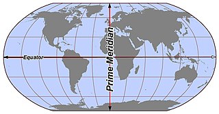
A prime meridian is an arbitrarily-chosen meridian in a geographic coordinate system at which longitude is defined to be 0°. Together, a prime meridian and its anti-meridian form a great circle. This great circle divides a spheroid, like Earth, into two hemispheres: the Eastern Hemisphere and the Western Hemisphere. For Earth's prime meridian, various conventions have been used or advocated in different regions throughout history. Earth's current international standard prime meridian is the IERS Reference Meridian. It is derived, but differs slightly, from the Greenwich Meridian, the previous standard.

The term "Old World" is an archaic 16th century term for Afro-Eurasia that originated in Europe c. 1493, after Europeans had become aware of the existence of the Americas. The term is one of several terms utilized to categorize and classify peoples and nations many view as having origins in colonialism and, by extension, racism. The term expresses Eurocentrism as it was used to contrast the continents of Africa, Europe, and Asia in the Eastern Hemisphere, previously thought of by Europeans as comprising the entire world, with the "New World", a term for the newly encountered lands of the Western Hemisphere, particularly the Americas. While located closer to Afro-Eurasia within the Eastern Hemisphere, Australia is considered neither an Old World nor a New World land, since it was only discovered by Europeans after the distinction had been made; both Australia and Antarctica were associated instead with the Terra Australis that had been posited as a hypothetical southern continent.

The Lesser Antilles are a group of islands in the Caribbean Sea. They are distinguished from the large islands of the Greater Antilles to the west. They form an arc which begins east of Puerto Rico and swings south through the Leeward and Windward Islands almost to South America and then turns west along the Venezuelan coast as far as Aruba. Barbados is isolated about 100 miles east of the Windwards.

The International Date Line (IDL) is the line between the South and North Poles that is the boundary between one calendar day and the next. It passes through the Pacific Ocean, roughly following the 180.0° line of longitude and deviating to pass around some territories and island groups. Crossing the date line eastbound decreases the date by one day, while crossing the date line westbound increases the date.
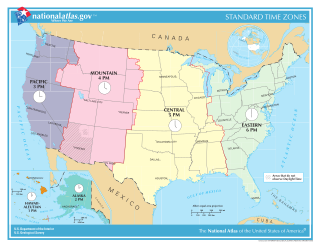
In the United States, time is divided into nine standard time zones covering the states, territories and other US possessions, with most of the country observing daylight saving time (DST) for approximately the spring, summer, and fall months. The time zone boundaries and DST observance are regulated by the Department of Transportation, but no single map of those existed until the agency announced intentions to make one in September 2022. Official and highly precise timekeeping services (clocks) are provided by two federal agencies: the National Institute of Standards and Technology (NIST) ; and the United States Naval Observatory (USNO). The clocks run by these services are kept synchronized with each other as well as with those of other international timekeeping organizations.

The Eastern Hemisphere is the half of the planet Earth which is east of the prime meridian and west of the antimeridian. It is also used to refer to Afro-Eurasia and Australia, in contrast with the Western Hemisphere, which includes mainly North and South America. The Eastern Hemisphere may also called the "Oriental Hemisphere", and may in addition be used in a cultural or geopolitical sense as a synonym for "Old World."

Semisopochnoi Island or Unyak Island is part of the Rat Islands group in the western Aleutian Islands of Alaska. The island is uninhabited and provides an important nesting area for maritime birds. The island is of volcanic origin, containing several volcanoes including Mount Young. It has a land area of 85.558 square miles, measuring 11 miles (18 km) in length and 12 miles (20 km) in width.

The 180th meridian or antimeridian is the meridian 180° both east and west of the prime meridian in a geographical coordinate system. The longitude at this line can be given as either east or west.

The Americas, also known as America, are lands of the Western Hemisphere, composed of numerous entities and regions variably defined by geography, politics, and culture.

Alaska occupies the northwestern portion of the North American continent and is bordered only by Canada on the east. It is one of two U.S. states not bordered by another state; Hawaii is the other. Alaska has more ocean coastline than all of the other U.S. states combined. About 500 miles (800 km) of Canadian territory separate Alaska from Washington state. Alaska is thus an exclave of the United States that is part of the continental U.S. and the U.S. West Coast, but is not part of the contiguous U.S.

Determining the boundaries between the continents is generally a matter of geographical convention. Several slightly different conventions are in use. The number of continents is most commonly considered seven but may range as low as four when Afro-Eurasia and the Americas are both considered as single continents. An island can be considered to be associated with a given continent by either lying on the continent's adjacent continental shelf or being a part of a microcontinent on the same principal tectonic plate. An island can also be entirely oceanic while still being associated with a continent by geology or by common geopolitical convention. Another example is the grouping into Oceania of the Pacific Islands with Australia and Zealandia.

The Aleutian Islands, also called the Aleut Islands or Aleutic Islands and known before 1867 as the Catherine Archipelago, are a chain of 14 large volcanic islands and 55 smaller islands. Most of the Aleutian Islands belong to the U.S. state of Alaska, but some belong to the Russian federal subject of Kamchatka Krai. They form part of the Aleutian Arc in the Northern Pacific Ocean, occupying a land area of 6,821 sq mi (17,666 km2) and extending about 1,200 mi (1,900 km) westward from the Alaska Peninsula toward the Kamchatka Peninsula in Russia, and act as a border between the Bering Sea to the north and the Pacific Ocean to the south. Crossing longitude 180°, at which point east and west longitude end, the archipelago contains both the westernmost part of the United States by longitude and the easternmost by longitude. The westernmost U.S. island in real terms, however, is Attu Island, west of which runs the International Date Line. While nearly all the archipelago is part of Alaska and is usually considered as being in the "Alaskan Bush", at the extreme western end, the small, geologically related Commander Islands belong to Russia.
In geography and cartography, hemispheres of Earth are any division of the globe into two equal halves (hemispheres), typically divided into northern and southern halves by the Equator or into western and eastern halves by the Prime meridian. Hemispheres can be divided geographically or culturally, or based on religion or prominent geographic features. Use of these divisions is applied when studying Earth's geographic distribution, cultural differences, and other geographic, demographic and socioeconomic features.
The IERS Reference Meridian (IRM), also called the International Reference Meridian, is the prime meridian maintained by the International Earth Rotation and Reference Systems Service (IERS). It passes about 5.3 arcseconds east of George Biddell Airy's 1851 transit circle which is 102 metres (335 ft) at the latitude of the Royal Observatory, Greenwich. Thus it differs slightly from the historical Greenwich Meridian.
