The geography of Antarctica is dominated by its south polar location and, thus, by ice. The Antarctic continent, located in the Earth's southern hemisphere, is centered asymmetrically around the South Pole and largely south of the Antarctic Circle. It is washed by the Southern Ocean or, depending on definition, the southern Pacific, Atlantic, and Indian Oceans. It has an area of more than 14 million km2. Antarctica is the largest ice desert in the world.

Canada has a vast geography that occupies much of the continent of North America, sharing a land border with the contiguous United States to the south and the U.S. state of Alaska to the northwest. Canada stretches from the Atlantic Ocean in the east to the Pacific Ocean in the west; to the north lies the Arctic Ocean. Greenland is to the northeast with a shared border on Hans Island. To the southeast Canada shares a maritime boundary with France's overseas collectivity of Saint Pierre and Miquelon, the last vestige of New France. By total area, Canada is the second-largest country in the world, after Russia. By land area alone, however, Canada ranks fourth, the difference being due to it having the world's largest proportion of fresh water lakes. Of Canada's thirteen provinces and territories, only two are landlocked while the other eleven all directly border one of three oceans.
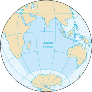
The Indian Ocean is the third-largest of the world's five oceanic divisions, covering 70,560,000 km2 (27,240,000 sq mi) or ~20% of the water on Earth's surface. It is bounded by Asia to the north, Africa to the west and Australia to the east. To the south it is bounded by the Southern Ocean, or Antarctica, depending on the definition in use. Along its core, the Indian Ocean has large marginal, or regional seas, such as the Arabian Sea, Laccadive Sea, Bay of Bengal and Andaman Sea.

The Northern Hemisphere is the half of Earth that is north of the Equator. For other planets in the Solar System, north is defined as being in the same celestial hemisphere relative to the invariable plane of the Solar System as Earth's North Pole.

The Pacific Ocean is the largest and deepest of Earth's five oceanic divisions. It extends from the Arctic Ocean in the north to the Southern Ocean in the south, and is bounded by the continents of Asia and Oceania in the west and the Americas in the east.
R'lyeh is a fictional lost city that was first mentioned in the H. P. Lovecraft short story "The Call of Cthulhu", first published in Weird Tales in February 1928. R'lyeh is a sunken city in the South Pacific and the prison of the entity called Cthulhu.

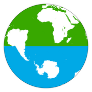
The Southern Hemisphere is the half (hemisphere) of Earth that is south of the Equator. It contains all or parts of five continents and four oceans, as well as New Zealand and most of the Pacific Islands in Oceania. Its surface is 80.9% water, compared with 60.7% water in the Northern Hemisphere, and it contains 32.7% of Earth's land.

Physical oceanography is the study of physical conditions and physical processes within the ocean, especially the motions and physical properties of ocean waters.

A pole of inaccessibility with respect to a geographical criterion of inaccessibility marks a location that is the most challenging to reach according to that criterion. Often it refers to the most distant point from the coastline, implying a maximum degree of continentality or oceanity. In these cases, a pole of inaccessibility can be defined as the center of the largest circle that can be drawn within an area of interest without encountering a coast. Where a coast is imprecisely defined, the pole will be similarly imprecise.

The trade winds or easterlies are the permanent east-to-west prevailing winds that flow in the Earth's equatorial region. The trade winds blow mainly from the northeast in the Northern Hemisphere and from the southeast in the Southern Hemisphere, strengthening during the winter and when the Arctic oscillation is in its warm phase. Trade winds have been used by captains of sailing ships to cross the world's oceans for centuries. They enabled colonial expansion into the Americas, and trade routes to become established across the Atlantic Ocean and the Pacific Ocean.

The South Orkney Islands are a group of islands in the Southern Ocean, about 604 km (375 mi) north-east of the tip of the Antarctic Peninsula and 844 km (524 mi) south-west of South Georgia Island. They have a total area of about 620 km2 (240 sq mi). The islands are claimed both by Britain, and by Argentina as part of Argentine Antarctica. Under the 1959 Antarctic Treaty, sovereignty claims are held in abeyance.
This article lists extreme locations on Earth that hold geographical records or are otherwise known for their geophysical or meteorological superlatives. All of these locations are Earth-wide extremes; extremes of individual continents or countries are not listed.

In oceanography, a gyre is any large system of circulating ocean surface currents, particularly those involved with large wind movements. Gyres are caused by the Coriolis effect; planetary vorticity, horizontal friction and vertical friction determine the circulatory patterns from the wind stress curl (torque).

The 180th meridian or antimeridian is the meridian 180° both east and west of the prime meridian in a geographical coordinate system. The longitude at this line can be given as either east or west.
The 45×90 points are the four points on Earth which are both halfway between one of the geographical poles and the equator, and halfway between the Prime Meridian and the 180th meridian. Both northern 45×90 points are located on land, while both southern 45×90 points are in remote open ocean locations.
Earth tide is the displacement of the solid earth's surface caused by the gravity of the Moon and Sun. Its main component has meter-level amplitude at periods of about 12 hours and longer. The largest body tide constituents are semi-diurnal, but there are also significant diurnal, semi-annual, and fortnightly contributions. Though the gravitational force causing earth tides and ocean tides is the same, the responses are quite different.
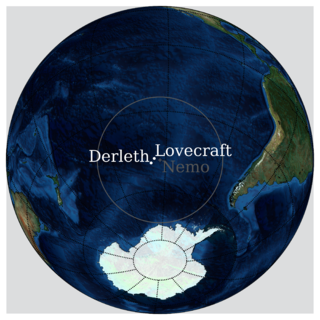
The spacecraft cemetery, known more formally as the South Pacific Ocean(ic) Uninhabited Area, is a region in the southern Pacific Ocean east of New Zealand, where spacecraft that have reached the end of their usefulness are routinely crashed. The area is roughly centered on "Point Nemo", the oceanic pole of inaccessibility, the location farthest from any land.
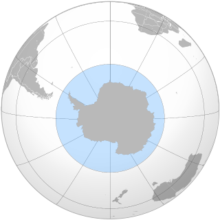
The Southern Ocean, also known as the Antarctic Ocean, comprises the southernmost waters of the world ocean, generally taken to be south of 60° S latitude and encircling Antarctica. With a size of 20,327,000 km2 (7,848,000 sq mi), it is regarded as the second-smallest of the five principal oceanic divisions: smaller than the Pacific, Atlantic, and Indian oceans but larger than the Arctic Ocean. Since the 1980s, the Southern Ocean has been subject to rapid climate change, which has led to changes in the marine ecosystem.

The borders of the oceans are the limits of Earth's oceanic waters. The definition and number of oceans can vary depending on the adopted criteria. The principal divisions of the five oceans are the Pacific Ocean, Atlantic Ocean, Indian Ocean, Southern (Antarctic) Ocean, and Arctic Ocean. Smaller regions of the oceans are called seas, gulfs, bays, straits, and other terms. Geologically, an ocean is an area of oceanic crust covered by water.
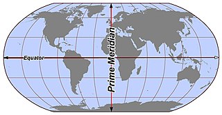
In geography and cartography, hemispheres of Earth are any division of the globe into two equal halves (hemispheres), typically divided into northern and southern halves by the equator or into western and eastern halves by an imaginary line passing through the poles. Hemispheres can be divided geographically, culturally, religiously, or based on prominent geographic features. Understanding these divisions is essential for studying Earth's geographic distribution, cultural differences, and the prominence of various geographic features.