
The Antarctic Treaty and related agreements, collectively known as the Antarctic Treaty System (ATS), regulate international relations with respect to Antarctica, Earth's only continent without a native human population. It was the first arms control agreement established during the Cold War, designating the continent as a scientific preserve, establishing freedom of scientific investigation, and banning military activity; for the purposes of the treaty system, Antarctica is defined as all the land and ice shelves south of 60°S latitude. Since September 2004, the Antarctic Treaty Secretariat, which implements the treaty system, is headquartered in Buenos Aires, Argentina.

Antarctic Circumpolar Current (ACC) is an ocean current that flows clockwise from west to east around Antarctica. An alternative name for the ACC is the West Wind Drift. The ACC is the dominant circulation feature of the Southern Ocean and has a mean transport estimated at 100–150 Sverdrups, or possibly even higher, making it the largest ocean current. The current is circumpolar due to the lack of any landmass connecting with Antarctica and this keeps warm ocean waters away from Antarctica, enabling that continent to maintain its huge ice sheet.

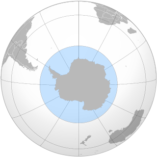
The Antarctic is a polar region around Earth's South Pole, opposite the Arctic region around the North Pole.

In physical geography, tundra is a type of biome where tree growth is hindered by frigid temperatures and short growing seasons. The term is a Russian word adapted from Sámi languages. There are three regions and associated types of tundra: Arctic tundra, alpine tundra, and Antarctic tundra.
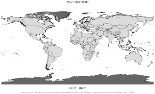
The polar climate regions are characterized by a lack of warm summers but with varying winters. Every month a polar climate has an average temperature of less than 10 °C (50 °F). Regions with a polar climate cover more than 20% of the Earth's area. Most of these regions are far from the equator and near the poles, and in this case, winter days are extremely short and summer days are extremely long. A polar climate consists of cool summers and very cold winters, which results in treeless tundra, glaciers, or a permanent or semi-permanent layer of ice. It is identified with the letter E in the Köppen climate classification.
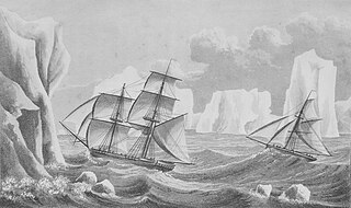
The history of Antarctica emerges from early Western theories of a vast continent, known as Terra Australis, believed to exist in the far south of the globe. The term Antarctic, referring to the opposite of the Arctic Circle, was coined by Marinus of Tyre in the 2nd century AD.

The British Antarctic Territory (BAT) is a sector of Antarctica claimed by the United Kingdom as one of its 14 British Overseas Territories, of which it is by far the largest by area. It comprises the region south of 60°S latitude and between longitudes 20°W and 80°W, forming a wedge shape that extends to the South Pole, overlapped by the Antarctic claims of Argentina and Chile. The claim to the region has been suspended since the Antarctic Treaty came into force in 1961.

The Antarctic Peninsula, known as O'Higgins Land in Chile and Tierra de San Martín in Argentina, and originally as Graham Land in the United Kingdom and the Palmer Peninsula in the United States, is the northernmost part of mainland Antarctica.

King George Island is the largest of the South Shetland Islands, lying 120 km off the coast of Antarctica in the Southern Ocean. The island was named after King George III.

The South Orkney Islands are a group of islands in the Southern Ocean, about 604 km (375 mi) north-east of the tip of the Antarctic Peninsula and 844 km (524 mi) south-west of South Georgia Island. They have a total area of about 620 km2 (240 sq mi). The islands are claimed both by Britain, and by Argentina as part of Argentine Antarctica. Under the 1959 Antarctic Treaty, sovereignty claims are held in abeyance.

The history of South Georgia and the South Sandwich Islands is relatively recent. When European explorers discovered the islands, they were uninhabited, and their hostile climate, mountainous terrain, and remoteness made subsequent settlement difficult. Due to these conditions, human activity in the islands has largely consisted of sealing, whaling, and scientific surveys and research, interrupted by World War II and the Falklands War.

The Chilean Antarctic Territory, or Chilean Antarctica, is a part of West Antarctica and nearby islands claimed by Chile. It comprises the region south of 60°S latitude and between longitudes 53°W and 90°W, partially overlapping the Antarctic claims of Argentina and of the United Kingdom. It constitutes the Antártica commune of Chile.

The subantarctic zone is a region in the Southern Hemisphere, located immediately north of the Antarctic region. This translates roughly to a latitude of between 46° and 60° south of the Equator. The subantarctic region includes many islands in the southern parts of the Atlantic, Indian, and Pacific oceans, especially those situated north of the Antarctic Convergence. Subantarctic glaciers are, by definition, located on islands within the subantarctic region. All glaciers located on the continent of Antarctica are by definition considered to be Antarctic glaciers.

The Antarctic Floristic Kingdom, also the Holantarctic Kingdom, is a floristic kingdom that includes most areas of the world south of 40°S latitude. It was first identified by botanist Ronald Good, and later by Armen Takhtajan. The Antarctic Floristic Kingdom is a classification in phytogeography, different from the Antarctic realm classification in biogeography, and from Antarctic flora genera/species classifications in botany.
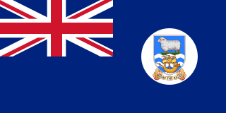
The Falkland Islands Dependencies was the constitutional arrangement from 1843 until 1985 for administering the various British territories in Sub-Antarctica and Antarctica which were governed from the Falkland Islands and its capital Stanley.
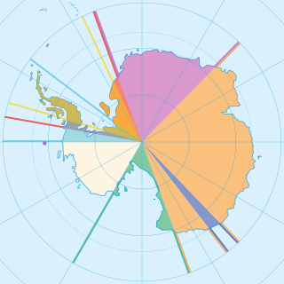
Seven sovereign states – Argentina, Australia, Chile, France, New Zealand, Norway, and the United Kingdom – have made eight territorial claims in Antarctica. These countries have tended to place their Antarctic scientific observation and study facilities within their respective claimed territories; however, a number of such facilities are located outside of the area claimed by their respective countries of operation, and countries without claims such as China, India, Italy, Japan, Pakistan, Russia, South Africa (SANAE), Poland, and the United States have constructed research facilities within the areas claimed by other countries. There are overlaps among the territories claimed by Argentina, Chile, and the United Kingdom.
The Southern Ocean, also known as the Antarctic Ocean, comprises the southernmost waters of the world ocean, generally taken to be south of 60° S latitude and encircling Antarctica. With a size of 20,327,000 km2 (7,848,000 sq mi), it is regarded as the second-smallest of the five principal oceanic divisions: smaller than the Pacific, Atlantic, and Indian oceans but larger than the Arctic Ocean.

Norway has three dependent territories, all uninhabited and located in the Southern Hemisphere. Bouvet Island (Bouvetøya) is a sub-Antarctic island in the South Atlantic Ocean. Queen Maud Land is the sector of Antarctica between the 20th meridian west and the 45th meridian east. Peter I Island is a volcanic island located 450 kilometres (280 mi) off the coast of Ellsworth Land of continental Antarctica. Despite being unincorporated areas, neither Svalbard nor Jan Mayen is formally considered a dependency. While the Svalbard Treaty regulates some aspects of that Arctic territory, it acknowledges that the islands are part of Norway. Similarly, Jan Mayen is recognized as an integral part of Norway.
Antarctic Intermediate Water (AAIW) is a cold, relatively low salinity water mass found mostly at intermediate depths in the Southern Ocean. The AAIW is formed at the ocean surface in the Antarctic Convergence zone or more commonly called the Antarctic Polar Front zone. This convergence zone is normally located between 50°S and 60°S, hence this is where almost all of the AAIW is formed.

The wildlife of Antarctica are extremophiles, having adapted to the dryness, low temperatures, and high exposure common in Antarctica. The extreme weather of the interior contrasts to the relatively mild conditions on the Antarctic Peninsula and the subantarctic islands, which have warmer temperatures and more liquid water. Much of the ocean around the mainland is covered by sea ice. The oceans themselves are a more stable environment for life, both in the water column and on the seabed.

