List of volcanoes in Antarctica

Last updated

Antarctica volcanoes (van Wyk de Vries, Bingham and Hein 2018).png

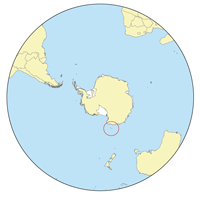
This is a list of volcanoes in Antarctica.

Table

A 2017 study claimed to have found 138 volcanoes, of which 91 were previously unknown. Some volcanoes are entirely under the ice sheet. [1] [2] Unconfirmed volcanoes are not included in the table below.

Contents

NameElevationLocationLast known eruption
metersfeet Coordinates
Mount Abbott [3] 1,020 [4] 3,346 [4] 74°42′S163°50′E / 74.700°S 163.833°E / -74.700; 163.833 (Adare Peninsula) [4]
Adare Peninsula [5] 2,083 [5] 6,832 [5] 71°40′S170°30′E / 71.667°S 170.500°E / -71.667; 170.500 (Adare Peninsula) [6] Pleistocene [5]
Mount Andrus [7] 2,978 [7] 9,768 [7] 75°48′S132°14′W / 75.800°S 132.233°W / -75.800; -132.233 (Mount Andrus) [8] Unknown [7]
Argo Point [9] 360 [9] 1,181 [9] 66°15′S60°55′W / 66.250°S 60.917°W / -66.250; -60.917 (Argo Point) [10] 0.9 Ma [9]
Beaufort Island [11] 740 [11] 2,427 [11] 76°56′S166°56′E / 76.933°S 166.933°E / -76.933; 166.933 (Beaufort Island) [12] Unknown [11]
Mount Berlin [13] 3,478 [13] 11,408 [13] 76°03′S135°52′W / 76.050°S 135.867°W / -76.050; -135.867 (Mount Berlin) [14] 8350 BCE ± 5300 years [13]
Mount Bird 1,765 [15] 5,791 [15] 77°16′S166°44′E / 77.267°S 166.733°E / -77.267; 166.733 (Mount bird) [15] 3.8-4.6 million years ago
Black Island [16] 1,041 [16] 3,414 [16] 78°12′S166°25′E / 78.200°S 166.417°E / -78.200; 166.417 (Black Island) [17] 1.69 Ma [16]
Bridgeman Island [18] 240 [18] 787 [18] 62°04′S56°44′W / 62.067°S 56.733°W / -62.067; -56.733 (Bridgeman Island) [19] Unknown [18]
Brown Bluff [20] 745 [20] 2,444 [20] 63°32′S56°55′W / 63.533°S 56.917°W / -63.533; -56.917 (Brown Peak) [20]
Brown Peak [21] 1,167 [21] 3,828 [21] 67°25′S164°35′E / 67.417°S 164.583°E / -67.417; 164.583 (Brown Peak) [22] Unknown [21]
Mount Bursey [23] 2,787 [23] 9,141 [23] 76°01′S132°38′W / 76.017°S 132.633°W / -76.017; -132.633 (Mount Bursey) [24] 0.49 Ma [23]
Coulman Island [25] 1,998 [25] 6,553 [25] 73°28′S169°45′E / 73.467°S 169.750°E / -73.467; 169.750 (Coulman Island) [26] -
Daniell Peninsula [25] 2,026 [25] 6,647 [25] 72°50′S169°35′E / 72.833°S 169.583°E / -72.833; 169.583 (Daniell Peninsula) [27] -
Deception Island [28] 602 [28] 1,975 [28] 62°57′S60°38′W / 62.950°S 60.633°W / -62.950; -60.633 (Deception Island) [29] 1970 [28]
Mount Discovery [30] 2,578 [30] 8,456 [30] 78°22′S165°01′E / 78.367°S 165.017°E / -78.367; 165.017 (Mount Discovery) [31] 1.87 Ma [30]
Mount Erebus [32] 3,794 [32] 12,444 [32] 77°31′S167°09′E / 77.517°S 167.150°E / -77.517; 167.150 (Mount Erebus) [33] 2018 [32]
Mount Frakes [34] 3,654 [34] 11,985 [34] 76°48′S117°42′W / 76.800°S 117.700°W / -76.800; -117.700 (Mount Frakes) [35] 1.7 Ma [34]
Franklin Island [36] 247 [36] 810 [36] 76°05′S168°19′E / 76.083°S 168.317°E / -76.083; 168.317 (Franklin Island) [37] Pleistocene [36]
Gaussberg [38] 370 [38] 1,214 [38] 66°48′S89°11′E / 66.800°S 89.183°E / -66.800; 89.183 (Gaussberg) [39] Pleistocene [38]
Mount Haddington [40] 1,630 [40] 5,346 [40] 64°13′S57°38′W / 64.217°S 57.633°W / -64.217; -57.633 (Mount Haddington) [41] Unknown [40]
Hallett Peninsula [25] 1,770 [25] 5,810 [25] 72°30′S170°10′E / 72.500°S 170.167°E / -72.500; 170.167 (Hallett Peninsula) [42]
Mount Hampton 3,325 [43] 10,909 [43] 76°29′S125°48′W / 76.483°S 125.800°W / -76.483; -125.800 (Mount Hampton) [43] -
Hudson Mountains [44] 749 [44] 2,457 [44] 74°25′S99°30′W / 74.417°S 99.500°W / -74.417; -99.500 (Hudson Mountains) [45] 210 BCE ± 200 years [44]
Lars Christensen Peak [46] 1,640 [46] 5,379 [46] 68°46′S90°31′W / 68.767°S 90.517°W / -68.767; -90.517 (Peter I Island) [47] Unknown [46]
Mount Melbourne [48] 2,732 [48] 8,961 [48] 74°21′S164°42′E / 74.350°S 164.700°E / -74.350; 164.700 (Mount Melbourne) [49] 1892 ± 30 years [48]
Melville Peak [50] 549 [50] 1,801 [50] 62°01′S57°41′W / 62.017°S 57.683°W / -62.017; -57.683 (Melville Peak) [51] Unknown [50]
Mount Morning [52] 2,723 [52] 8,931 [52] 78°31′S163°35′E / 78.517°S 163.583°E / -78.517; 163.583 (Mount Morning) [53] Unknown [52]
Mount Moulton 3,070 [54] 10,072 [54] 76°03′S135°08′W / 76.050°S 135.133°W / -76.050; -135.133 (Mount Moulton) [54] -
Mount Murphy [55] 2,703 [55] 8,866 [55] 75°20′S110°44′W / 75.333°S 110.733°W / -75.333; -110.733 (Mount Murphy) [56] 0.9 Ma [55]
Mount Overlord 3,395 [57] 11,138 [57] 73°10′S164°36′E / 73.167°S 164.600°E / -73.167; 164.600 (Mount Overlord) [57] -
Paulet Island [58] 353 [58] 1,158 [58] 63°35′S55°47′W / 63.583°S 55.783°W / -63.583; -55.783 (Paulet Island) [59] Unknown [58]
Penguin Island [60] 180 [60] 590 [60] 62°06′S57°54′W / 62.100°S 57.900°W / -62.100; -57.900 (Penguin Island) [61] 1905 (?) [60]
The Pleiades [62] 3,040 [62] 9,971 [62] 72°42′S165°32′E / 72.700°S 165.533°E / -72.700; 165.533 (The Pleiades) [63] 1050 BC ± 1000 years [62]
Red Island [64] 495 [64] 1,624 [64] 63°44′S57°52′W / 63.733°S 57.867°W / -63.733; -57.867 (Red Island) [64]
Mount Rittmann [65] 2,600 [65] 8,530 [65] 1252 ± 2 years [66]
Rosamel Island [67] 2,600 [67] 8,530 [67] 78°10′S162°40′E / 78.167°S 162.667°E / -78.167; 162.667 (Rosamel Island) [67]
Royal Society Range [68] 3,000 [68] 9,840 [68] 78°10′S162°40′E / 78.167°S 162.667°E / -78.167; 162.667 (Royal Society Volcano) [69] Unknown [68]
Seal Nunataks [70] 368 [70] 1,207 [70] 65°03′S60°18′W / 65.050°S 60.300°W / -65.050; -60.300 (Seal Nunataks) [71] Unknown [70]
Mount Sidley 4,285 [72] 14,058 [72] 77°02′S126°06′W / 77.033°S 126.100°W / -77.033; -126.100 (Mount Sidley) [72] -
Mount Siple [73] 3,110 [73] 10,201 [73] 73°15′S126°06′W / 73.250°S 126.100°W / -73.250; -126.100 (Mount Siple) [74] Unknown [73]
Mount Steere [34] 3,500 [75] 11,482 [75] 76°44′S117°49′W / 76.733°S 117.817°W / -76.733; -117.817 (Mount Steere) [75] -
Mount Takahe [76] 3,460 [76] 11,349 [76] 76°17′S112°05′W / 76.283°S 112.083°W / -76.283; -112.083 (Mount Takahe) [77] 5550 BCE (?) [76]
Mount Terra Nova [78] 2,130 [79] 6,988 [79] 77°31′S167°57′W / 77.517°S 167.950°W / -77.517; -167.950 (Mount Terra Nova) [79] 0.8 Ma [78]
Mount Terror [78] 3,262 [78] 10,699 [78] 77°31′S168°32′E / 77.517°S 168.533°E / -77.517; 168.533 (Mount Terror) [80] 0.82 Ma [78]
Toney Mountain [81] 3,595 [81] 11,792 [81] 75°48′S115°48′W / 75.800°S 115.800°W / -75.800; -115.800 (Toney Mountain) [82] Unknown [81]
Mount Vernon Harcourt 1,570 [83] 5,151 [83] 72°32′S169°55′E / 72.533°S 169.917°E / -72.533; 169.917 (Mount Harcourt) [83] -
Mount Waesche [84] 3,292 [84] 10,801 [84] 77°10′S126°54′W / 77.167°S 126.900°W / -77.167; -126.900 (Mount Waesche) [85] Unknown [84]

See also

Related Research Articles

<span class="mw-page-title-main">Mount Erebus</span> Volcano on Ross Island, Antarctica

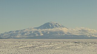
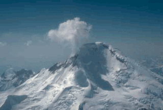
Mount Erebus is the second-highest volcano in Antarctica, the highest active volcano in Antarctica, and the southernmost active volcano on Earth. It is the sixth-highest highest point of an island, and the second most prominent mountain in Antarctica after Mount Vinson. It has a summit elevation of 3,794 metres (12,448 ft). It is located in the Ross Dependency on Ross Island, which is also home to three inactive volcanoes: Mount Terror, Mount Bird, and Mount Terra Nova. The mountain was named by Captain James Clark Ross in 1841 for his ship, the Erebus.

<span class="mw-page-title-main">Brown Peak (Sturge Island)</span> Mountain in Ross Dependency, Antarctica

Brown Peak is a stratovolcano and the highest point of the Balleny Islands. It is situated on the northern part of Sturge Island.

<span class="mw-page-title-main">Mount Terror (Antarctica)</span> Shield volcano in Antarctica

Mount Terror is an extinct volcano about 3,230 metres (10,600 ft) high on Ross Island, Antarctica, about 20 nautical miles eastward of Mount Erebus. Mount Terror was named in 1841 by Sir James Clark Ross for his second ship, HMS Terror. The captain of Terror was Francis Crozier, a close friend of Ross for whom the nearby Cape Crozier is named.

<span class="mw-page-title-main">Bellingshausen Island</span> Island in the Southern Thule group of the South Sandwich Islands

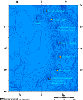
Bellingshausen Island is one of the most southerly of the South Sandwich Islands, close to Thule Island and Cook Island, and forming part of the Southern Thule group. It is named after its discoverer, Russian Antarctic explorer Fabian von Bellingshausen (1778–1852).

<span class="mw-page-title-main">Mount Discovery</span> Volcano in Victoria Land, Antarctica

Mount Discovery is a conspicuous, isolated volcanic cone, 2,680 metres (8,790 ft) high, lying at the head of McMurdo Sound and east of Koettlitz Glacier, overlooking the northwest portion of the Ross Ice Shelf. It forms the center of a three-armed mass of which Brown Peninsula is one extension to the north; Minna Bluff is a second to the east; the third is Mount Morning to the west. Mount Discovery was discovered by the British National Antarctic Expedition (1901–04) and named for their expedition ship Discovery.

<span class="mw-page-title-main">Mount Griggs</span> Stratovolcano in the state of Alaska

Mount Griggs, formerly known as Knife Peak Volcano, is a stratovolcano, which lies 10 km behind the volcanic arc defined by other Katmai group volcanoes. Although no historic eruptions have been reported from Mount Griggs, vigorously active fumaroles persist in a summit crater and along the upper southwest flank. The fumaroles on the southwest flank are the hottest, and some of the flank fumaroles can roar so loudly that they can be heard from the valley floor. The slopes of Mount Griggs are heavily mantled by fallout from the 1912 eruption of Novarupta volcano. The summit consists of three concentric craters, the lowest and largest of which contains a recent summit cone topped by two craters. The volume of the volcanic edifice is estimated at about 25 cubic kilometers (6.0 cu mi). Isotopic analysis indicates that the source of Griggs' magma is distinct from the other Katmai volcanoes.

<span class="mw-page-title-main">Mount Mageik</span>

Mount Mageik is a stratovolcano on the Alaska Peninsula. It has no confirmed historical eruptions, but its youngest eruptive products are apparently Holocene in age. A young crater lies on the northeast flank of the central summit cone, and is the site of vigorous superheated fumarolic activity with prominent sulfur deposits. The volcanic cones are composed of andesite, basaltic andesite and dacite.

<span class="mw-page-title-main">Pyre Peak</span>

Pyre Peak, also called Seguam Volcano, is an active stratovolcano on Seguam Island in the Aleutian Islands of Alaska.

<span class="mw-page-title-main">Mount Iliamna</span> Stratovolcano in United States

Iliamna Volcano, or Mount Iliamna, is a glacier-covered stratovolcano in the largely volcanic Aleutian Range in southwest Alaska. Located in the Chigmit Mountain subrange in Lake Clark National Park and Preserve, the 10,016-foot (3,053 m) volcano lies approximately 134 miles (215 km) southwest of Anchorage on the west side of lower Cook Inlet. It is the 25th most prominent peak in the United States.

<span class="mw-page-title-main">White Island (Ross Archipelago)</span>

White Island is an island in the Ross Archipelago of Antarctica. It is 15 nautical miles long, protruding through the Ross Ice Shelf immediately east of Black Island. It was discovered by the British National Antarctic Expedition (1901–04) and so named by them because of the mantle of snow which covers it.

<span class="mw-page-title-main">Lava lake</span> Molten lava contained in a volcanic crater

Lava lakes are large volumes of molten lava, usually basaltic, contained in a volcanic vent, crater, or broad depression. The term is used to describe both lava lakes that are wholly or partly molten and those that are solidified.

<span class="mw-page-title-main">Black Island (Ross Archipelago)</span> Island in the Ross Archipelago, Antarctica

Black Island, is an island in the Ross Archipelago, 12 nautical miles long, projecting through the Ross Ice Shelf to a height of 1,040 metres (3,410 ft).meters. It was discovered by the British National Antarctic Expedition and named by them for its appearance. The island is largely ice free and principally composed of black volcanic rock. The island's northernmost point is named Cape Hodgson, commemorating Thomas Vere Hodgson, one of the oldest members of the Discovery Expedition.

<span class="mw-page-title-main">Cinnamon Butte</span> Volcanic geological formation in Oregon

Cinnamon Butte is a group of cinder cone volcanoes and lava domes in the Cascade Range of Oregon. All of the vents are older than approximately 6,845 years as they are all covered in ash from the eruption of Mount Mazama.

<span class="mw-page-title-main">Davis Lake volcanic field</span>

The Davis Lake volcanic field, is a volcanic field with a group of andesitic cinder cones, lava flows and basaltic andesite shield volcano. The field is located east of the Cascade Range of Oregon, United States.

Mount Haddington is a massive 1,630 m (5,350 ft) high shield volcano comprising much of James Ross Island in Graham Land, Antarctica. It is 60 km (37 mi) wide and has had numerous subglacial eruptions throughout its history, forming many tuyas. Some of its single eruptions were bigger in volume than a whole normal-sized volcano. Old eruption shorelines are widespread on the volcano's deeply eroded flanks.

<span class="mw-page-title-main">Mount Hodson</span>

Mount Hodson is an ice-covered stratovolcano and the highest point on Visokoi Island, South Sandwich Islands. It might have erupted in 1830 and 1930, and the summit usually steams. Named after Sir Arnold Wienholt Hodson (1881–1944), Governor of the Falkland Islands and Dependencies, 1926–1930.

Mount Bursey is a broad, ice-covered mountain, 2,780 metres (9,120 ft) high, which forms the eastern end of the Flood Range in Marie Byrd Land, Antarctica.

<span class="mw-page-title-main">Mount Kauffman</span> Mountain in Marie Byrd Land, Antarctica

Mount Kauffman is a prominent mountain, 2,365 metres (7,760 ft) high, that surmounts the northwest end of the Ames Range in Marie Byrd Land, Antarctica. It was mapped by the United States Geological Survey from surveys and U.S. Navy air photos, 1959–65, and named by the Advisory Committee on Antarctic Names for Commander S.K. Kauffman, U.S. Navy, a staff civil engineering officer who supervised the planning and building of Plateau Station, 1965–66.

References

  1. van Wyk de Vries, Maximillian; Bingham, Robert G.; Hein, Andrew S. (2018). "A new volcanic province: an inventory of subglacial volcanoes in West Antarctica". Geological Society, London, Special Publications. 461 (1): 231–248. Bibcode:2018GSLSP.461..231V. doi: 10.1144/sp461.7 . hdl: 20.500.11820/53d5003b-838f-4ba0-ac03-ffafafe5efa5 .
  2. McKie, Robin (2017-08-12). "Scientists discover 91 volcanoes below Antarctic ice sheet". The Observer. ISSN   0029-7712 . Retrieved 2017-09-20.
  3. "K/Ar and Rb/Sr dating of McMurdo Volcanic Group (north of Campbell Glacier)" (PDF). Geological Society of America. p. 2.
  4. 1 2 3 "Mount Abbott". Geographic Names Information System . United States Geological Survey, United States Department of the Interior . Retrieved 2020-03-21.
  5. 1 2 3 4 "Adare Peninsula". Global Volcanism Program . Smithsonian Institution . Retrieved 2018-01-20.
  6. "Adare Peninsula". Geographic Names Information System . United States Geological Survey, United States Department of the Interior . Retrieved 2018-01-21.
  7. 1 2 3 4 "Andrus". Global Volcanism Program . Smithsonian Institution . Retrieved 2018-01-20.
  8. "Mount Andrus". Geographic Names Information System . United States Geological Survey, United States Department of the Interior . Retrieved 2018-01-21.
  9. 1 2 3 4 "Argo Point". Global Volcanism Program . Smithsonian Institution . Retrieved 2018-01-20.
  10. "Argo Point". Geographic Names Information System . United States Geological Survey, United States Department of the Interior . Retrieved 2018-01-21.
  11. 1 2 3 4 "Beaufort Island". Global Volcanism Program . Smithsonian Institution . Retrieved 2018-01-20.
  12. "Beaufort Island". Geographic Names Information System . United States Geological Survey, United States Department of the Interior . Retrieved 2018-01-21.
  13. 1 2 3 4 "Berlin". Global Volcanism Program . Smithsonian Institution . Retrieved 2018-01-20.
  14. "Mount Berlin". Geographic Names Information System . United States Geological Survey, United States Department of the Interior . Retrieved 2018-01-21.
  15. 1 2 3 "Mount Bird". Geographic Names Information System . United States Geological Survey, United States Department of the Interior . Retrieved 2018-01-21.
  16. 1 2 3 4 "Black Island". Global Volcanism Program . Smithsonian Institution . Retrieved 2018-01-20.
  17. "Black Island". Geographic Names Information System . United States Geological Survey, United States Department of the Interior . Retrieved 2018-01-21.
  18. 1 2 3 4 "Bridgeman Island". Global Volcanism Program . Smithsonian Institution . Retrieved 2018-01-20.
  19. "Bridgeman Island". Geographic Names Information System . United States Geological Survey, United States Department of the Interior . Retrieved 2018-01-21.
  20. 1 2 3 4 "Brown Bluff". Geographic Names Information System . United States Geological Survey, United States Department of the Interior . Retrieved 2021-01-29.
  21. 1 2 3 4 "Sturge Island". Global Volcanism Program . Smithsonian Institution . Retrieved 2018-01-21.
  22. "Brown Peak". Geographic Names Information System . United States Geological Survey, United States Department of the Interior . Retrieved 2018-01-21.
  23. 1 2 3 4 "Bursey". Global Volcanism Program . Smithsonian Institution . Retrieved 2018-01-20.
  24. "Mount Bursey". Geographic Names Information System . United States Geological Survey, United States Department of the Interior . Retrieved 2018-01-21.
  25. 1 2 3 4 5 6 7 8 9 Smellie, J. L.; Rocchi, S.; Armienti, P. (2011). "Late Miocene volcanic sequences in northern Victoria Land, Antarctica: products of glaciovolcanic eruptions under different thermal regimes". Bulletin of Volcanology . 73 (1). Springer: 4. Bibcode:2011BVol...73....1S. doi:10.1007/s00445-010-0399-y. ISSN   0258-8900.
  26. "Coulman Island". Geographic Names Information System . United States Geological Survey, United States Department of the Interior . Retrieved 2018-01-21.
  27. "Daniell Peninsula". Geographic Names Information System . United States Geological Survey, United States Department of the Interior . Retrieved 2020-03-21.
  28. 1 2 3 4 "Deception Island". Global Volcanism Program . Smithsonian Institution . Retrieved 2018-01-20.
  29. "Deception Island". Geographic Names Information System . United States Geological Survey, United States Department of the Interior . Retrieved 2018-01-21.
  30. 1 2 3 4 "Discovery". Global Volcanism Program . Smithsonian Institution . Retrieved 2018-01-20.
  31. "Mount Discovery". Geographic Names Information System . United States Geological Survey, United States Department of the Interior . Retrieved 2018-01-21.
  32. 1 2 3 4 "Erebus". Global Volcanism Program . Smithsonian Institution . Retrieved 2018-01-20.
  33. "Mount Erebus". Geographic Names Information System . United States Geological Survey, United States Department of the Interior . Retrieved 2018-01-21.
  34. 1 2 3 4 5 "Crary Group". Global Volcanism Program . Smithsonian Institution . Retrieved 2018-01-20.
  35. "Mount Frakes". Geographic Names Information System . United States Geological Survey, United States Department of the Interior . Retrieved 2018-01-20.
  36. 1 2 3 4 "Franklin Island". Global Volcanism Program . Smithsonian Institution . Retrieved 2018-01-20.
  37. "Franklin Island". Geographic Names Information System . United States Geological Survey, United States Department of the Interior . Retrieved 2018-01-21.
  38. 1 2 3 4 "Gaussberg". Global Volcanism Program . Smithsonian Institution . Retrieved 2018-01-20.
  39. "Gaussberg". Geographic Names Information System . United States Geological Survey, United States Department of the Interior . Retrieved 2018-01-21.
  40. 1 2 3 4 "James Ross Island". Global Volcanism Program . Smithsonian Institution . Retrieved 2018-01-20.
  41. "Mount Haddington". Geographic Names Information System . United States Geological Survey, United States Department of the Interior . Retrieved 2018-01-20.
  42. "Hallett Peninsula". Geographic Names Information System . United States Geological Survey, United States Department of the Interior . Retrieved 2020-03-21.
  43. 1 2 3 "Mount Hampton". Geographic Names Information System . United States Geological Survey, United States Department of the Interior . Retrieved 2018-01-21.
  44. 1 2 3 4 "Hudson Mountains". Global Volcanism Program . Smithsonian Institution . Retrieved 2018-01-20.
  45. "Hudson Mountains". Geographic Names Information System . United States Geological Survey, United States Department of the Interior . Retrieved 2018-01-21.
  46. 1 2 3 4 "Peter I Island". Global Volcanism Program . Smithsonian Institution . Retrieved 2018-01-20.
  47. "Lars Christensen Peak". Geographic Names Information System . United States Geological Survey, United States Department of the Interior . Retrieved 2018-01-21.
  48. 1 2 3 4 "Melbourne". Global Volcanism Program . Smithsonian Institution . Retrieved 2018-01-20.
  49. "Mount Melbourne". Geographic Names Information System . United States Geological Survey, United States Department of the Interior . Retrieved 2018-01-21.
  50. 1 2 3 4 "Melville". Global Volcanism Program . Smithsonian Institution . Retrieved 2018-01-20.
  51. "Melville Peak". Geographic Names Information System . United States Geological Survey, United States Department of the Interior . Retrieved 2018-01-21.
  52. 1 2 3 4 "Morning". Global Volcanism Program . Smithsonian Institution . Retrieved 2018-01-20.
  53. "Mount Morning". Geographic Names Information System . United States Geological Survey, United States Department of the Interior . Retrieved 2018-01-21.
  54. 1 2 3 "Mount Moulton". Geographic Names Information System . United States Geological Survey, United States Department of the Interior . Retrieved 2018-01-21.
  55. 1 2 3 4 "Murphy". Global Volcanism Program . Smithsonian Institution . Retrieved 2018-01-20.
  56. "Mount Murphy". Geographic Names Information System . United States Geological Survey, United States Department of the Interior . Retrieved 2018-01-21.
  57. 1 2 3 "Mount Overlord". Geographic Names Information System . United States Geological Survey, United States Department of the Interior . Retrieved 2018-01-21.
  58. 1 2 3 4 "Paulet". Global Volcanism Program . Smithsonian Institution . Retrieved 2018-01-20.
  59. "Paulet Island". Geographic Names Information System . United States Geological Survey, United States Department of the Interior . Retrieved 2018-01-21.
  60. 1 2 3 4 "Penguin Island". Global Volcanism Program . Smithsonian Institution . Retrieved 2018-01-20.
  61. "Penguin Island". Geographic Names Information System . United States Geological Survey, United States Department of the Interior . Retrieved 2018-01-21.
  62. 1 2 3 4 "The Pleiades". Global Volcanism Program . Smithsonian Institution . Retrieved 2018-01-20.
  63. "The Pleiades". Geographic Names Information System . United States Geological Survey, United States Department of the Interior . Retrieved 2018-01-21.
  64. 1 2 3 4 "Red Island". Geographic Names Information System . United States Geological Survey, United States Department of the Interior . Retrieved 2021-01-29.
  65. 1 2 3 "Rittmann". Global Volcanism Program . Smithsonian Institution . Retrieved 2020-03-21.
  66. Lee, Mi Jung; Kyle, Philip R.; Iverson, Nels A.; Lee, Jong Ik; Han, Yeongcheol (1 September 2019). "Rittmann volcano, Antarctica as the source of a widespread 1252 ± 2 CE tephra layer in Antarctica ice". Earth and Planetary Science Letters. 521: 169. Bibcode:2019E&PSL.521..169L. doi: 10.1016/j.epsl.2019.06.002 . ISSN   0012-821X.
  67. 1 2 3 4 "Rosamel Island". Geographic Names Information System . United States Geological Survey, United States Department of the Interior . Retrieved 2021-01-29.
  68. 1 2 3 4 "Royal Society Range". Global Volcanism Program . Smithsonian Institution . Retrieved 2018-01-20.
  69. "Royal Society Range". Geographic Names Information System . United States Geological Survey, United States Department of the Interior . Retrieved 2018-01-21.
  70. 1 2 3 4 "Seal Nunataks Group". Global Volcanism Program . Smithsonian Institution . Retrieved 2018-01-20.
  71. "Seal Nunataks". Geographic Names Information System . United States Geological Survey, United States Department of the Interior . Retrieved 2018-01-21.
  72. 1 2 3 "Mount Sidley". Geographic Names Information System . United States Geological Survey, United States Department of the Interior . Retrieved 2018-01-21.
  73. 1 2 3 4 "Siple". Global Volcanism Program . Smithsonian Institution . Retrieved 2018-01-20.
  74. "Mount Siple". Geographic Names Information System . United States Geological Survey, United States Department of the Interior . Retrieved 2018-01-21.
  75. 1 2 3 "Mount Steere". Geographic Names Information System . United States Geological Survey, United States Department of the Interior . Retrieved 2018-01-21.
  76. 1 2 3 4 "Takahe". Global Volcanism Program . Smithsonian Institution . Retrieved 2018-01-20.
  77. "Mount Takahe". Geographic Names Information System . United States Geological Survey, United States Department of the Interior . Retrieved 2018-01-21.
  78. 1 2 3 4 5 6 "Terror". Global Volcanism Program . Smithsonian Institution . Retrieved 2018-01-20.
  79. 1 2 3 "Mount Terra Nova". Geographic Names Information System . United States Geological Survey, United States Department of the Interior . Retrieved 2018-01-21.
  80. "Mount Terror". Geographic Names Information System . United States Geological Survey, United States Department of the Interior . Retrieved 2018-01-21.
  81. 1 2 3 4 "Toney Mountain". Global Volcanism Program . Smithsonian Institution . Retrieved 2018-01-20.
  82. "Toney Mountain". Geographic Names Information System . United States Geological Survey, United States Department of the Interior . Retrieved 2018-01-21.
  83. 1 2 3 "Mount Vernon Harcourt". Geographic Names Information System . United States Geological Survey, United States Department of the Interior . Retrieved 2018-01-21.
  84. 1 2 3 4 "Waesche". Global Volcanism Program . Smithsonian Institution . Retrieved 2020-05-27.
  85. "Mount Waesche". Geographic Names Information System . United States Geological Survey, United States Department of the Interior . Retrieved 2020-05-27.

Bibliography