In meteorology, a cloud is an aerosol consisting of a visible mass of miniature liquid droplets, frozen crystals, or other particles suspended in the atmosphere of a planetary body or similar space. Water or various other chemicals may compose the droplets and crystals. On Earth, clouds are formed as a result of saturation of the air when it is cooled to its dew point, or when it gains sufficient moisture from an adjacent source to raise the dew point to the ambient temperature.

Convection is single or multiphase fluid flow that occurs spontaneously due to the combined effects of material property heterogeneity and body forces on a fluid, most commonly density and gravity. When the cause of the convection is unspecified, convection due to the effects of thermal expansion and buoyancy can be assumed. Convection may also take place in soft solids or mixtures where particles can flow.

Cumulonimbus is a dense, towering vertical cloud, typically forming from water vapor condensing in the lower troposphere that builds upward carried by powerful buoyant air currents. Above the lower portions of the cumulonimbus the water vapor becomes ice crystals, such as snow and graupel, the interaction of which can lead to hail and to lightning formation, respectively. When occurring as a thunderstorm these clouds may be referred to as thunderheads. Cumulonimbus can form alone, in clusters, or along squall lines. These clouds are capable of producing lightning and other dangerous severe weather, such as tornadoes, hazardous winds, and large hailstones. Cumulonimbus progress from overdeveloped cumulus congestus clouds and may further develop as part of a supercell. Cumulonimbus is abbreviated Cb.

Cumulus clouds are clouds which have flat bases and are often described as "puffy", "cotton-like" or "fluffy" in appearance. Their name derives from the Latin cumulo-, meaning heap or pile. Cumulus clouds are low-level clouds, generally less than 2,000 m (6,600 ft) in altitude unless they are the more vertical cumulus congestus form. Cumulus clouds may appear by themselves, in lines, or in clusters.

Water vapor, water vapour or aqueous vapor is the gaseous phase of water. It is one state of water within the hydrosphere. Water vapor can be produced from the evaporation or boiling of liquid water or from the sublimation of ice. Water vapor is transparent, like most constituents of the atmosphere. Under typical atmospheric conditions, water vapor is continuously generated by evaporation and removed by condensation. It is less dense than most of the other constituents of air and triggers convection currents that can lead to clouds.

The lapse rate is the rate at which an atmospheric variable, normally temperature in Earth's atmosphere, falls with altitude. Lapse rate arises from the word lapse, in the sense of a gradual fall. In dry air, the adiabatic lapse rate is 9.8 °C/km.

In the field of fluid dynamics, a convection cell is the phenomenon that occurs when density differences exist within a body of liquid or gas. These density differences result in rising and/or falling currents, which are the key characteristics of a convection cell. When a volume of fluid is heated, it expands and becomes less dense and thus more buoyant than the surrounding fluid. The colder, denser part of the fluid descends to settle below the warmer, less-dense fluid, and this causes the warmer fluid to rise. Such movement is called convection, and the moving body of liquid is referred to as a convection cell. This particular type of convection, where a horizontal layer of fluid is heated from below, is known as Rayleigh–Bénard convection. Convection usually requires a gravitational field, but in microgravity experiments, thermal convection has been observed without gravitational effects.
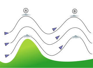
In meteorology, lee waves are atmospheric stationary waves. The most common form is mountain waves, which are atmospheric internal gravity waves. These were discovered in 1933 by two German glider pilots, Hans Deutschmann and Wolf Hirth, above the Krkonoše. They are periodic changes of atmospheric pressure, temperature and orthometric height in a current of air caused by vertical displacement, for example orographic lift when the wind blows over a mountain or mountain range. They can also be caused by the surface wind blowing over an escarpment or plateau, or even by upper winds deflected over a thermal updraft or cloud street.

Cloud physics is the study of the physical processes that lead to the formation, growth and precipitation of atmospheric clouds. These aerosols are found in the troposphere, stratosphere, and mesosphere, which collectively make up the greatest part of the homosphere. Clouds consist of microscopic droplets of liquid water, tiny crystals of ice, or both. Cloud droplets initially form by the condensation of water vapor onto condensation nuclei when the supersaturation of air exceeds a critical value according to Köhler theory. Cloud condensation nuclei are necessary for cloud droplets formation because of the Kelvin effect, which describes the change in saturation vapor pressure due to a curved surface. At small radii, the amount of supersaturation needed for condensation to occur is so large, that it does not happen naturally. Raoult's law describes how the vapor pressure is dependent on the amount of solute in a solution. At high concentrations, when the cloud droplets are small, the supersaturation required is smaller than without the presence of a nucleus.

Cumulus humilis are cumuliform clouds with little vertical extent, common in the summer, that are often referred to as "fair weather cumulus". If they develop into cumulus mediocris or cumulus congestus, thunderstorms could form later in the day.

In meteorology, convective available potential energy, is the integrated amount of work that the upward (positive) buoyancy force would perform on a given mass of air if it rose vertically through the entire atmosphere. Positive CAPE will cause the air parcel to rise, while negative CAPE will cause the air parcel to sink. Nonzero CAPE is an indicator of atmospheric instability in any given atmospheric sounding, a necessary condition for the development of cumulus and cumulonimbus clouds with attendant severe weather hazards.

Cumulus mediocris is a low to middle level cloud with some vertical extent of the genus cumulus, larger in vertical development than Cumulus humilis. It also may exhibit small protuberances from the top and may show the cauliflower form characteristic of cumulus clouds. Cumulus mediocris clouds do not generally produce precipitation of more than very light intensity, but can further advance into clouds such as Cumulus congestus or Cumulonimbus, which do produce precipitation and severe storms.
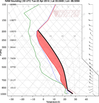
In meteorology, convective instability or stability of an air mass refers to its ability to resist vertical motion. A stable atmosphere makes vertical movement difficult, and small vertical disturbances dampen out and disappear. In an unstable atmosphere, vertical air movements tend to become larger, resulting in turbulent airflow and convective activity. Instability can lead to significant turbulence, extensive vertical clouds, and severe weather such as thunderstorms.

An air-mass thunderstorm, also called an "ordinary", "single cell", or "garden variety" thunderstorm, is a thunderstorm that is generally weak and usually not severe. These storms form in environments where at least some amount of Convective Available Potential Energy (CAPE) is present, but very low levels of wind shear and helicity. The lifting source, which is a crucial factor in thunderstorm development, is usually the result of uneven heating of the surface, though they can be induced by weather fronts and other low-level boundaries associated with wind convergence. The energy needed for these storms to form comes in the form of insolation, or solar radiation. Air-mass thunderstorms do not move quickly, last no longer than an hour, and have the threats of lightning, as well as showery light, moderate, or heavy rainfall. Heavy rainfall can interfere with microwave transmissions within the atmosphere.

Atmospheric convection is the result of a parcel-environment instability, or temperature difference layer in the atmosphere. Different lapse rates within dry and moist air masses lead to instability. Mixing of air during the day which expands the height of the planetary boundary layer leads to increased winds, cumulus cloud development, and decreased surface dew points. Moist convection leads to thunderstorm development, which is often responsible for severe weather throughout the world. Special threats from thunderstorms include hail, downbursts, and tornadoes.

Atmospheric instability is a condition where the Earth's atmosphere is generally considered to be unstable and as a result the weather is subjected to a high degree of variability through distance and time. Atmospheric stability is a measure of the atmosphere's tendency to discourage or deter vertical motion, and vertical motion is directly correlated to different types of weather systems and their severity. In unstable conditions, a lifted thing, such as a parcel of air will be warmer than the surrounding air at altitude. Because it is warmer, it is less dense and is prone to further ascent.
Lift is a meteorological phenomenon used as an energy source by soaring aircraft and soaring birds. The most common human application of lift is in sport and recreation. The three air sports that use soaring flight are: gliding, hang gliding and paragliding.

Gliding is a recreational activity and competitive air sport in which pilots fly unpowered aircraft known as gliders or sailplanes using naturally occurring currents of rising air in the atmosphere to remain airborne. The word soaring is also used for the sport.

A castellanus is a cloud that displays at least in its upper part cumuliform protuberances having the shape of turrets that give a crenellated aspect. Some of these turrets are higher than they are wide; they have a common base and seem to be arranged in a line. The castellanus characteristic is particularly obvious when the clouds are observed from the side.
This glossary of meteorology is a list of terms and concepts relevant to meteorology and atmospheric science, their sub-disciplines, and related fields.