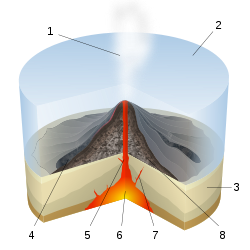
A volcano is a rupture in the crust of a planetary-mass object, such as Earth, that allows hot lava, volcanic ash, and gases to escape from a magma chamber below the surface.

A seamount is a large submarine landform that rises from the ocean floor without reaching the water surface, and thus is not an island, islet, or cliff-rock. Seamounts are typically formed from extinct volcanoes that rise abruptly and are usually found rising from the seafloor to 1,000–4,000 m (3,300–13,100 ft) in height. They are defined by oceanographers as independent features that rise to at least 1,000 m (3,281 ft) above the seafloor, characteristically of conical form. The peaks are often found hundreds to thousands of meters below the surface, and are therefore considered to be within the deep sea. During their evolution over geologic time, the largest seamounts may reach the sea surface where wave action erodes the summit to form a flat surface. After they have subsided and sunk below the sea surface such flat-top seamounts are called "guyots" or "tablemounts".
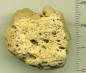
Pumice, called pumicite in its powdered or dust form, is a volcanic rock that consists of highly vesicular rough-textured volcanic glass, which may or may not contain crystals. It is typically light-colored. Scoria is another vesicular volcanic rock that differs from pumice in having larger vesicles, thicker vesicle walls, and being dark colored and denser.

The fifteen volcanoes that make up the eight principal islands of Hawaii are the youngest in a chain of more than 129 volcanoes that stretch 5,800 kilometers (3,600 mi) across the North Pacific Ocean, called the Hawaiian–Emperor seamount chain. Hawaiʻi's volcanoes rise an average of 4,600 meters (15,000 ft) to reach sea level from their base. The largest, Mauna Loa, is 4,169 meters (13,678 ft) high. As shield volcanoes, they are built by accumulated lava flows, growing a few meters or feet at a time to form a broad and gently sloping shape.
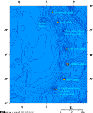
Protector Shoal is the shallowest point of the Protector Seamounts, a group of submarine volcanoes in the Southern Ocean. They are part of the South Sandwich island arc, a volcanic arc that has given rise to the South Sandwich Islands. Protector Shoal reaches a depth of 55 metres (180 ft) below sea level and is part of a larger group of seamounts that formed atop a larger ridge. Some of these seamounts bear traces of sector collapses, and one is capped by nested calderas.

The Juan de Fuca Ridge is a mid-ocean spreading center and divergent plate boundary located off the coast of the Pacific Northwest region of North America, named after Juan de Fuca. The ridge separates the Pacific Plate to the west and the Juan de Fuca Plate to the east. It runs generally northward, with a length of approximately 500 kilometres (310 mi). The ridge is a section of what remains from the larger Pacific-Farallon Ridge which used to be the primary spreading center of this region, driving the Farallon Plate underneath the North American Plate through the process of plate tectonics. Today, the Juan de Fuca Ridge pushes the Juan de Fuca Plate underneath the North American plate, forming the Cascadia Subduction Zone.

Several types of volcanic eruptions—during which lava, tephra, and assorted gases are expelled from a volcanic vent or fissure—have been distinguished by volcanologists. These are often named after famous volcanoes where that type of behavior has been observed. Some volcanoes may exhibit only one characteristic type of eruption during a period of activity, while others may display an entire sequence of types all in one eruptive series.

James Healy Seamount is a submarine volcano located among the South Kermadec Ridge Seamounts south of New Zealand's Kermadec Islands. It consists of a volcanic cone that reaches a depth of 1,150 metres (3,770 ft) below sea level, two 2–2.5 kilometres (1.2–1.6 mi) and 1.3 kilometres (0.81 mi) wide calderas and a parasitic cone that reaches a depth of 950 metres (3,120 ft) below sea level. The flanks of the volcano are covered with pumice and volcanic rocks, and hydrothermal venting occurs inside the caldera.
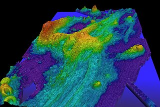
Axial Seamount is a seamount, submarine volcano, and underwater shield volcano in the Pacific Ocean, located on the Juan de Fuca Ridge, approximately 480 km (298 mi) west of Cannon Beach, Oregon. Standing 1,100 m (3,609 ft) high, Axial Seamount is the youngest volcano and current eruptive center of the Cobb–Eickelberg Seamount chain. Located at the center of both a geological hotspot and a mid-ocean ridge, the seamount is geologically complex, and its origins are still poorly understood. Axial Seamount is set on a long, low-lying plateau, with two large rift zones trending 50 km (31 mi) to the northeast and southwest of its center. The volcano features an unusual rectangular caldera, and its flanks are pockmarked by fissures, vents, sheet flows, and pit craters up to 100 m (328 ft) deep; its geology is further complicated by its intersection with several smaller seamounts surrounding it.

Bowie Seamount, or SG̱aan Ḵinghlas in the Haida language, is a large submarine volcano in the northeastern Pacific Ocean, located 180 km (110 mi) west of Haida Gwaii, British Columbia, Canada. The seamount is also known as Bowie Bank. The English name for the feature is after William Bowie of the United States Coast and Geodetic Survey.

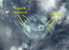
Submarine eruptions are volcano eruptions which take place beneath the surface of water. These occur at constructive margins, subduction zones and within tectonic plates due to hotspots. This eruption style is far more prevalent than subaerial activity. For example, it is believed that 70 to 80% of the Earth's magma output takes place at mid-ocean ridges.

West Mata is an active submarine volcano located in the northeastern Lau Basin, roughly 200 km (124 mi) southwest of the Samoan Islands. It is part of the Tonga-Kermadec volcanic arc, which stretches from the North Island of New Zealand to Samoa. The volcano was first discovered in 2008 by scientists aboard the R/V Thompson research vessel, using sonar mapping and a remotely operated vehicle (ROV) to explore the seafloor. At the same time West Mata was discovered, multiple neighboring volcanoes—most of them hydrothermally active—were discovered as well, including Volcano O, Tafu-Maka, Northern Matas and East Mata.

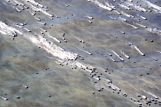
The 2012 Kermadec Islands eruption was a major undersea volcanic eruption that was produced by the previously little-known Havre Seamount near the L'Esperance and L'Havre Rocks in the Kermadec Islands of New Zealand. The large volume of low density pumice produced by the eruption accumulated as a large area of floating pumice, a pumice raft, that was originally covering a surface of 400 square kilometres, spread to a continuous float of between 19,000 and 26,000 square kilometres and within three months dispersed to an area of more than twice the size of New Zealand.
Macdonald seamount is a seamount in Polynesia, southeast of the Austral Islands and in the neighbourhood of a system of seamounts that include the Ngatemato seamounts and the Taukina seamounts. It rises 4,200 metres (13,800 ft) from the seafloor to a depth of about 40 metres (130 ft) and has a flat top, but the height of its top appears to vary with volcanic activity. There are some subsidiary cones such as Macdocald seamount. The seamount was discovered in 1967 and has been periodically active with gas release and seismic activity since then. There is hydrothermal activity on Macdonald, and the vents are populated by hyperthermophilic bacteria.
A lava balloon is a gas-filled bubble of lava that floats on the sea surface. It can be up to several metres in size. When it emerges from the sea, it is usually hot and often steaming. After floating for some time it fills with water and sinks again.
Monowai Seamount is a volcanic seamount to the north of New Zealand. It is formed by a large caldera and a volcanic cone just south-southeast from the caldera. The volcanic cone rises to depths of up to 100 metres (330 ft) but its depth varies with ongoing volcanic activity, including sector collapses and the growth of lava domes. The seamount and its volcanism were discovered after 1877, but only in 1980 was it named "Monowai" after a research ship of the same name.
South Arch volcanic field is an underwater volcanic field south of Hawaiʻi Island. It was active during the last 10,000 years, and covers an area of 35 by 50 kilometres at a depth of 4,950 metres (16,240 ft).

NW Rota-1 is a seamount in the Mariana Islands, northwest of Rota, which was discovered through its hydrothermal activity in 2003. The volcano has been observed to be erupting underwater, the first time that submarine explosive eruptions have been directly witnessed.

Daikoku Seamount is a submarine volcano located in the Northern Mariana Islands, in the western Pacific Ocean. It is part of a chain of volcanoes and seamounts that includes the more known Ahyi Seamount and NW Rota-1 seamounts and is situated about 690 km (429 mi) north of the island of Saipan. Daikoku Seamount rises over 2,500 m (8,202 ft) meters from the seafloor, with its summit about 323 m (1,060 ft) below sea level. Since its discovery, the seamount has been studied by several expeditions, including expeditions made by NOAA, using various scientific tools, such as sonar mapping and remotely operated vehicles (ROVs). Daikoku Seamount is known for its active hydrothermal vent system, which hosts diverse communities of deep-sea organisms, including tube worms, crabs, and snails. The seamount is also one of the only volcanoes along with Nikkō Seamount to have had a partially molten sulfur lake, which is usually a feature seen on Io than on Earth.

Ahyi Seamount is an active shallow submarine volcano in the Northern Mariana Islands, in the Northwestern Pacific Ocean. It has erupted 3 times since the year 2000; in 2001, 2014 and 2022–23. Since 2009, it has been a part of Marianas Trench Marine National Monument of the United States.