A caldera is a large cauldron-like hollow that forms shortly after the emptying of a magma chamber in a volcano eruption. When large volumes of magma are erupted over a short time, structural support for the rock above the magma chamber is gone. The ground surface then collapses into the emptied or partially emptied magma chamber, leaving a large depression at the surface. Although sometimes described as a crater, the feature is actually a type of sinkhole, as it is formed through subsidence and collapse rather than an explosion or impact. Compared to the thousands of volcanic eruptions that occur each century, the formation of a caldera is a rare event, occurring only a few times per century. Only seven caldera-forming collapses are known to have occurred between 1911 and 2016. More recently, a caldera collapse occurred at Kīlauea, Hawaii in 2018.

Mount Vesuvius is a somma-stratovolcano located on the Gulf of Naples in Campania, Italy, about 9 km (5.6 mi) east of Naples and a short distance from the shore. It is one of several volcanoes forming the Campanian volcanic arc. Vesuvius consists of a large cone partially encircled by the steep rim of a summit caldera, resulting from the collapse of an earlier, much higher structure.

The Ring of Fire is a tectonic belt, about 40,000 km (25,000 mi) long and up to about 500 km (310 mi) wide, which circumscribes the Pacific Ocean. It contains between 750 and 915 volcanoes, around two-thirds of the world total, and 90% of the world's earthquakes, including 81% of its largest, take place within the belt.

Atlasov Island, known in Russian as Ostrov Atlasova (Остров Атласова), or in Japanese as Araido (阿頼度島), is the northernmost island and volcano and also the highest volcano of the Kuril islands, part of the Sakhalin Oblast in Russia. The Russian name is sometimes rendered in English as Atlasova Island. Other names for the island include Uyakhuzhach, Oyakoba (Ainu) and Alaid, the name of the volcano on the island.

An active volcano is a volcano that has erupted during the Holocene, is currently erupting, or has the potential to erupt in the future. A volcano that is not currently erupting but could erupt in the future is known as a dormant volcano. Volcanoes that will not erupt again are known as extinct volcanoes.
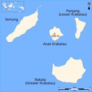
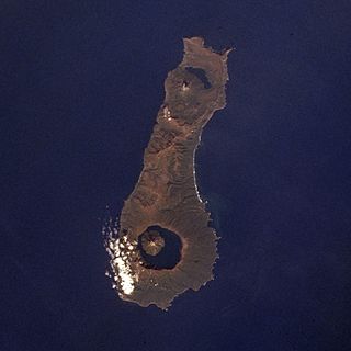
Rakata, also called Greater Krakatau, is a partially collapsed and uninhabited stratovolcano on the Indonesian island of Krakatoa in the Sunda Strait between the islands of Sumatra and Java. Standing 813 m (2,667 ft) tall, it was the largest and southernmost of three volcanoes that formed the island Krakatoa and the only one not totally destroyed in the 1883 eruption. Rakata is the last remnant of the original island prior to its destruction. However, Rakata did lose its northern half in that eruption, leaving just its southern half. The exposed cliff is quite striking visually, partially of a large exposed dike terminating in a large lenticular extrusion at the middle of the almost vertical cliff. The feature has been called "the Eye of Krakatoa."

Anak Krakatoa is a volcanic island in Indonesia. On 29 December 1927, Anak Krakatoa first emerged from the caldera formed in 1883 by the explosive volcanic eruption that destroyed the island of Krakatoa. There has been sporadic eruptive activity at the site since the late 20th century, culminating with a large underwater collapse of the volcano that caused a deadly tsunami in December 2018. There has been subsequent activity since. Due to its young age, the island is one of several in the area that are of interest to, and the subject of extensive study by, volcanologists.

Mount Somma is a mountain located in the Province of Naples, in the Campania region of southern Italy. It is 1,132 metres (3,714 ft) high. It is an integral part of the Somma–Vesuvius volcanic complex and of the larger Campanian volcanic arc, which is known for its high levels of seismic and volcanic activity.

A complex volcano, also called a compound volcano or a volcanic complex, is a mixed landform consisting of related volcanic centers and their associated lava flows and pyroclastic rock. They may form due to changes in eruptive habit or in the location of the principal vent area on a particular volcano. Stratovolcanoes can also form a large caldera that gets filled in by a lava dome, or else multiple small cinder cones, lava domes and craters may develop on the caldera's rim.

Simushir, meaning Large Island in Ainu, is an uninhabited volcanic island near the center of the Kuril Islands chain in the Sea of Okhotsk in the northwest Pacific Ocean. It was formerly known as Marikan.

Kambalny is a stratovolcano located in the southern part of the Kamchatka Peninsula, Russia. It is the southernmost active volcano of Kamchatka. It has erupted mafic rocks. It has a summit crater as well as five cinder cones on its flanks which are the source of lava flows.

Taunshits is a stratovolcano located in the eastern part of the Kamchatka Peninsula, Russia.
Nemo Peak is a stratovolcano located at the northern end of Onekotan Island, Kuril Islands, Russia. It is truncated by two nested calderas, with the cone of Nemo Peak itself rising in the southwest end of the youngest caldera and a crater lake partially filling the northeast part, named Ozero Chernoye.
Tao-Rusyr Caldera is a stratovolcano located at the southern end of Onekotan Island, Kuril Islands, Russia. It has 7.5 km wide caldera formed during a catastrophic eruption less than 10,000 years ago. The waters of Kol'tsevoe Lake fill the caldera, along with a large symmetrical andesitic cone, Krenitsyn Peak, that rises as an island within the lake. This volcano was named after Captain Pyotr Krenitsyn of the Imperial Russian Navy.
Uratman is a somma volcano located at the northern end of Simushir Island, Kuril Islands, Russia. It overlooks the Brouton Bay which is contained within the crater. The volcano consists of a Pleistocene caldera which contains an andesite cone of Holocene age.

Tyatya is a volcano located in the northeastern part of Kunashir Island, Kuril Islands, Russia. It is the highest peak on the island with an elevation of 1,819 metres (5,968 ft). Tyatya is one of the finest examples anywhere in the world of a somma volcano, a stratovolcano whose summit has collapsed to form a caldera which has then been mostly refilled by a new, younger volcanic cone which rises above the caldera rim.

The Kamchatka Volcanic Eruption Response Team (KVERT) is a Russian national institution dedicated to provide information of any volcanic activity taking place on the Kamchatka Peninsula and the Kuril Islands of Russia that could become a threat to local communities and aviation. It was established in 1993 by the Far Eastern Branch of the Russian Academy of Sciences, Institute of Volcanic Geology and Seismology under cooperation with the Kamchatkan Branch of Geophysical Survey. The Alaska Volcano Observatory (AVO), United States Geological Survey (USGS) and its affiliates also provide joint efforts to the program. The KVERT website, posted in both Russian and English, allows users to view information on volcanoes in the region and monitor reports of active volcanoes. A section also provides webcameras at select locations that update regularly. Currently, around 66 active volcanoes are routinely monitored. The majority of the volcanoes on the Kuril Islands are monitored by the Sakhalin Volcanic Eruption Response Team (SVERT), which is located in Yuzhno-Sakhalinsk, but all reports of volcanic activity in the island chain are posted in joint effort on the KVERT website.

