Forensic geophysics

Last updated

Forensic geophysics is a branch of forensic science and is the study, the search, the localization and the mapping of buried objects or elements beneath the soil or the water, using geophysics tools for legal purposes. [1] There are various geophysical techniques for forensic investigations in which the targets are buried and have different dimensions (from weapons or metallic barrels to human burials and bunkers). Geophysical methods have the potential to aid the search and the recovery of these targets because they can non-destructively and rapidly investigate large areas where a suspect, illegal burial or, in general, a forensic target is hidden in the subsoil. When in the subsurface there is a contrast of physical properties between a target and the material in which it is buried, it is possible to individuate and define precisely the concealing place of the searched target. It is also possible to recognize evidences of human soil occupation or excavation, both recent and older. Forensic geophysics is an evolving technique that is gaining popularity and prestige in law enforcement. [2]

Contents

Searched for objects obviously include clandestine graves of murder victims, but also include unmarked burials in graveyards and cemeteries, weapons used in criminal activities and environmental crime illegally dumping material.

There are various near-surface geophysical techniques that can be utilised to detect a near-surface buried object, which should be site and case-specific. A thorough desk study (including historical maps), utility survey, site reconnaissance and control studies should be undertaken before trial geophysical surveys and then full geophysical surveys are undertaken in phased investigations. Note also other search techniques should be used to first to prioritise suspect areas, for example cadaver dogs or forensic geomorphologists. [3]

Techniques

For large-scale buried objects, seismic surveys may be appropriate but these have, at best, 2m vertical resolution so may not be ideal for certain targets, more typically they are used to detect bedrock below the surface. [4]

For relatively quick site surveys, bulk ground electrical conductivity surveys can be collected which identifies areas of disturbance of different ground but these can suffer from a lack of resolution. This recent Black Death investigation in central London [5] shows an example. [6] shows a successful woodland search for a cold case in woodland in New Zealand.

Ground-penetrating radar (or GPR) has a typical maximum depth below ground level (bgl) of 10 m, depending upon the antennae frequencies used, typically 50 MHz to 1.2 Gz. The higher the frequency the smaller the object that can be resolved but also penetration depths decrease, so operators need to think carefully when choosing antennae frequencies and, ideally, undertake trial surveys using different antennae over a target at a known depth onsite. GPR is the most popularly used technique in forensic search, but is not suitable in certain soil types and environments, e.g. coastal (i.e. salt-rich) and clay-rich soils (lack of penetration). 2D profiles can be relatively quickly collected and, if time permits, successive profiles can be used to generate 3D datasets which may resolve more subtle targets. [4] Recent studies have used GPR to locate mass graves from the Spanish Civil War in mountainous [7] and urban [8] environments.

Electrical resistivity methods can also detect objects, especially in clay-rich soil which would preclude the use of GPR. There are different equipment configurations, the dipole-dipole (fixed-offset) method is the most common which can traverse across an area, measuring resistivity variations at a set depth (typically 1-2x probe separations) which have been used in forensic searches. More slower methods are putting out many probes and collecting both spatially horizontally and vertically, called Electrical resistivity imaging (ERI). Multiple 2D profiles is termed electrical resistivity tomography (ERT). [9]

Magnetometry can detect buried metal (or indeed fired objects such as bricks or even where surface fires were) using simple total field magnetometers, through to fluxgate gradiometers and high-end alkali vapour gradiometers, depending upon accuracy (and cost) required. [4] Surface magnetic susceptibility has also shown recent promise for forensic search.

Water-based searches are also becoming more common, [10] with specialist marine magnetometers, side-scan sonar [11] and other acoustic methods and even water-penetrating radar [12] methods used to rapidly scan bottoms of ponds, lakes, rivers and near-shore depositional environments.

Controlled research

There has been recent efforts to undertake research over known buried and below-water surface simulated forensic targets in order to gain an insight into optimum search technique(s) and/or equipment configuration(s). Most commonly, this involved the burial porcine cadavers and long-term monitoring for soilwater, [13] seasonal effects on electrical resistivity surveys, burial in walls and beneath concrete, [14] and Long-Term monitoring in the UK, [15] the US [16] and Latin America. [17] Finally there has been surveys in graveyards over graves of known ages to determine the geophysical responses of multi-geophysical techniques with increasing burial ages [18]

See also

Related Research Articles

<span class="mw-page-title-main">Forensic science</span> Application of science to criminal and civil laws

Forensic science, also known as criminalistics, is the application of science principles and methods to support legal decision-making in matters of criminal and civil law.

<span class="mw-page-title-main">Geophysics</span> Physics of the Earth and its vicinity

Geophysics is a subject of natural science concerned with the physical processes and physical properties of the Earth and its surrounding space environment, and the use of quantitative methods for their analysis. Geophysicists, who usually study geophysics, physics, or one of the Earth sciences at the graduate level, complete investigations across a wide range of scientific disciplines. The term geophysics classically refers to solid earth applications: Earth's shape; its gravitational, magnetic fields, and electromagnetic fields ; its internal structure and composition; its dynamics and their surface expression in plate tectonics, the generation of magmas, volcanism and rock formation. However, modern geophysics organizations and pure scientists use a broader definition that includes the water cycle including snow and ice; fluid dynamics of the oceans and the atmosphere; electricity and magnetism in the ionosphere and magnetosphere and solar-terrestrial physics; and analogous problems associated with the Moon and other planets.

<span class="mw-page-title-main">Forensic palynology</span> Forensic application of the study of particulate matter

Forensic palynology is a subdiscipline of palynology, that aims to prove or disprove a relationship among objects, people, and places that may pertain to both criminal and civil cases. Pollen can reveal where a person or object has been, because regions of the world, countries, and even different parts of a single garden will have a distinctive pollen assemblage. Pollen evidence can also reveal the season in which a particular object picked up the pollen. Recent research into forensic palynology has seen advancements in DNA barcoding from pollen, to the level of singular pollen molecules, allowing DNA profiles to be created from singular palynomorphs, streamlining the efficiency and accuracy of taxonomic identification.

<span class="mw-page-title-main">Geophysical survey (archaeology)</span> Non-invasive physical sensing techniques used for archaeological imaging or mapping

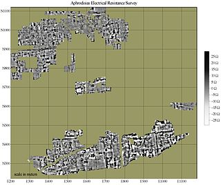
In archaeology, geophysical survey is ground-based physical sensing techniques used for archaeological imaging or mapping. Remote sensing and marine surveys are also used in archaeology, but are generally considered separate disciplines. Other terms, such as "geophysical prospection" and "archaeological geophysics" are generally synonymous.

<span class="mw-page-title-main">Post-mortem interval</span> Time that has elapsed since a person has died

The post-mortem interval (PMI) is the time that has elapsed since an individual's death. When the time of death is not known, the interval may be estimated, and so an approximate time of death established. Postmortem interval estimations can range from hours, to days or even years depending on the type of evidence present. There are standard medical and scientific techniques supporting such an estimation.

<span class="mw-page-title-main">Ground-penetrating radar</span> Geophysical method that uses radar pulses to image the subsurface

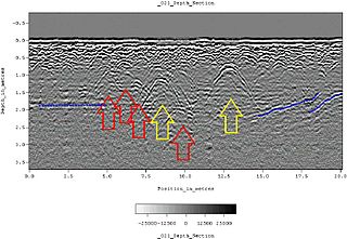
Ground-penetrating radar (GPR) is a geophysical method that uses radar pulses to image the subsurface. It is a non-intrusive method of surveying the sub-surface to investigate underground utilities such as concrete, asphalt, metals, pipes, cables or masonry. This nondestructive method uses electromagnetic radiation in the microwave band of the radio spectrum, and detects the reflected signals from subsurface structures. GPR can have applications in a variety of media, including rock, soil, ice, fresh water, pavements and structures. In the right conditions, practitioners can use GPR to detect subsurface objects, changes in material properties, and voids and cracks.

Exploration geophysics is an applied branch of geophysics and economic geology, which uses physical methods at the surface of the Earth, such as seismic, gravitational, magnetic, electrical and electromagnetic, to measure the physical properties of the subsurface, along with the anomalies in those properties. It is most often used to detect or infer the presence and position of economically useful geological deposits, such as ore minerals; fossil fuels and other hydrocarbons; geothermal reservoirs; and groundwater reservoirs. It can also be used to detect the presence of unexploded ordnance.

<span class="mw-page-title-main">International Union of Geodesy and Geophysics</span> International non-governmental organization

The International Union of Geodesy and Geophysics is an international non-governmental organization dedicated to the scientific study of Earth and its space environment using geophysical and geodetic techniques.

Radioglaciology is the study of glaciers, ice sheets, ice caps and icy moons using ice penetrating radar. It employs a geophysical method similar to ground-penetrating radar and typically operates at frequencies in the MF, HF, VHF and UHF portions of the radio spectrum. This technique is also commonly referred to as "Ice Penetrating Radar (IPR)" or "Radio Echo Sounding (RES)".

<span class="mw-page-title-main">Interferometric synthetic-aperture radar</span> Geodesy and remote sensing technique

Interferometric synthetic aperture radar, abbreviated InSAR, is a radar technique used in geodesy and remote sensing. This geodetic method uses two or more synthetic aperture radar (SAR) images to generate maps of surface deformation or digital elevation, using differences in the phase of the waves returning to the satellite or aircraft. The technique can potentially measure millimetre-scale changes in deformation over spans of days to years. It has applications for geophysical monitoring of natural hazards, for example earthquakes, volcanoes and landslides, and in structural engineering, in particular monitoring of subsidence and structural stability.

<span class="mw-page-title-main">Forensic geology</span>

Forensic geology is the study of evidence relating to materials found in the Earth used to answer questions raised by the legal system.

<span class="mw-page-title-main">Geophysical imaging</span>

Geophysical imaging is a minimally destructive geophysical technique that investigates the subsurface of a terrestrial planet. Geophysical imaging is a noninvasive imaging technique with a high parametrical and spatio-temporal resolution. It can be used to model a surface or object understudy in 2D or 3D as well as monitor changes.

Carmen Gaina is the Director of the Centre for Earth Evolution and Dynamics (CEED) a Norwegian Centre of Excellence hosted at the Department of Geosciences, University of Oslo, Norway.

<span class="mw-page-title-main">Near-surface geophysics</span> Geophysics of first tens of meters below surface

Near-surface geophysics is the use of geophysical methods to investigate small-scale features in the shallow subsurface. It is closely related to applied geophysics or exploration geophysics. Methods used include seismic refraction and reflection, gravity, magnetic, electric, and electromagnetic methods. Many of these methods were developed for oil and mineral exploration but are now used for a great variety of applications, including archaeology, environmental science, forensic science, military intelligence, geotechnical investigation, treasure hunting, and hydrogeology. In addition to the practical applications, near-surface geophysics includes the study of biogeochemical cycles.

Anya Marie Reading is a professor of Geophysics and Associate Head of Research in the School of Natural Sciences, University of Tasmania.

<span class="mw-page-title-main">Kamini Singha</span> American hydrogeologist

Kamini Singha is a Professor in the department of Geology and Geological Engineering at the Colorado School of Mines, where she works on questions related to hydrogeology.

Alexander Peter Annan is an engineer whose research focuses on near-surface geophysics. He has made significant contributions to the development of ground-penetrating radar (GPR) technology. Annan is the CEO of Sensors & Software, a company he founded to commercialize GPR technology. He has been working on the development of GPR since the 1970s and was one of the lead researchers on the surface electrical properties experiment conducted on the Moon during the Apollo 17 mission.

<span class="mw-page-title-main">Forensic colorimetry</span> Color analysis technique

Forensic colorimetry, or forensic color analysis, is the examination of specimen color for purposes of forensic investigation. Typical specimens involved in color analyses include pigments, dyes, or other objects that are distinguishable by their intrinsic color. Analyses may be conducted by-eye or by computational methods, both by matching specimen colors to a standardised chart or database.

<span class="mw-page-title-main">Irina Artemieva</span> Earth scientist and academic

Irina M. Artemieva is Professor of Geophysics at the GEOMAR Helmholtz Centre for Ocean Research in Kiel (Germany), Distinguished Professor at the China University of Geosciences (Wuhan), and Distinguished Professor at SinoProbe at the Chinese Academy of Geological Sciences (Beijing).

Subir Kumar Banerjee is an Indian-American geophysicist, known for research on rock magnetism, palaeomagnetism, and environmental magnetism.

References

  1. Pringle, JK; Ruffell, A; Jervis, JR; Donnelly, L; McKinley, J; Hansen, J; Morgan, R; Pirrie, D; Harrison, M (2012). "The use of geoscience methods for terrestrial forensic searches". Earth-Science Reviews. 114 (1–2): 108–123. Bibcode:2012ESRv..114..108P. doi:10.1016/j.earscirev.2012.05.006.
  2. Larson, DO; Vass, AA; Wise, M (2011). "Advanced Scientific Methods and Procedures in the Forensic Investigation of Clandestine Graves". Journal of Contemporary Criminal Justice. 27 (2): 149–182. doi:10.1177/1043986211405885. S2CID   110373603.
  3. Ruffell, A; McKinley, J (2014). "Forensic geomorphology" (PDF). Geomorphology. 206: 14–22. Bibcode:2014Geomo.206...14R. doi:10.1016/j.geomorph.2013.12.020.
  4. 1 2 3 Reynolds, JR (2011). An Introduction to Applied and Environmental Geophysics, 2nd Edition. Wiley. ISBN   978-0-471-48535-3.
  5. Dick, HC; Pringle, JK; Sloane, B; Carver, J; Wisneiwski, KD; Haffenden, A; Porter, S; Roberts, D; Cassidy, NJ (2015). "Detection and characterisation of Black Death burials by multi-proxy geophysical methods" (PDF). Journal of Archaeological Science. 59: 132–141. Bibcode:2015JArSc..59..132D. doi:10.1016/j.jas.2015.04.010.
  6. Nobes, D (2000). "The Search for "Yvonne": A Case Example of the Delineation of a Grave Using Near-Surface Geophysical Methods". Journal of Forensic Sciences. 45 (3): 715–721. doi:10.1520/JFS14756J. PMID   10855986.
  7. Fernandez-Alvarez, J-P (2016). "Discovery of a mass grave from the Spanish Civil War using Ground Penetrating Radar and forensic archaeology". Forensic Science International. 267 (10): e10–e17. doi:10.1016/j.forsciint.2016.05.040. PMID   27318840.
  8. Fernandez-Alvarez, J-P (2018). "GPR and ERT detection and characterization of a mass burial, Spanish Civil War, Northern Spain" (PDF). Forensic Science International. 287: e1–e9. doi:10.1016/j.forsciint.2018.03.034. PMID   29636200.
  9. Pye, Kenneth; D.J. Croft (2004). Forensic geoscience: principles, techniques and applications. Geological Society of London. ISBN   978-1-86239-161-1.
  10. Ruffell, A; Pringle, JK; Cassella, JP; Morgan, RM; Ferguson, M; Heaton, V; Hope, C; McKinley, J (2017). "The use of geoscience methods for aquatic forensic searches" (PDF). Earth-Science Reviews. 171: 323–337. Bibcode:2017ESRv..171..323R. doi:10.1016/j.earscirev.2017.04.012.
  11. Schultz, JJ; Healy, CA; Parker, K; Lowers, B (2013). "Detecting submerged objects: The application of side scan sonar to forensic contexts". Forensic Science International. 231 (1–3): 306–316. doi:10.1016/j.forsciint.2013.05.032. PMID   23890654.
  12. Ruffell, A (2009). "Under-water Scene Investigation Using Ground Penetrating Radar (GPR) in the Search for a Sunken Jet ski, Northern Ireland". Science & Justice. 46 (4): 221–230. doi:10.1016/S1355-0306(06)71602-1. PMID   17500424.
  13. Pringle, Jamie K.; Cassella, John P.; Jervis, John R.; Williams, Anna; Cross, Peter; Cassidy, Nigel J. (2015-07-01). "Soilwater Conductivity Analysis to Date and Locate Clandestine Graves of Homicide Victims" (PDF). Journal of Forensic Sciences. 60 (4): 1052–1060. doi:10.1111/1556-4029.12802. ISSN   1556-4029. PMID   26190264. S2CID   12082791.
  14. Ruffell, A; Pringle, JK; Forbes, S (2014-01-05). "Search protocols for hidden forensic objects beneath floors and within walls" (PDF). Forensic Science International. 237: 237–245. doi:10.1016/j.forsciint.2013.12.036. PMID   24582079.
  15. Pringle, Jamie K.; Stimpson, Ian G.; Wisniewski, Kris D.; Heaton, Vivienne; Davenward, Ben; Mirosch, Natalie; Spencer, Francesca; Jervis, Jon (2020-05-05). "Geophysical monitoring of simulated homicide burials for forensic investigations". Scientific Reports. 61 (2): 309–321. Bibcode:2020NatSR..10.7544P. doi: 10.1038/s41598-020-64262-3 . PMC   7200741 . PMID   32371989.
  16. Schultz, John J.; Walter, Brittany S.; Healy, Carrie (2016-09-01). "Long-term sequential monitoring of controlled graves representing common burial scenarios with ground penetrating radar: Years 2 and 3". Journal of Applied Geophysics. 132: 60–74. Bibcode:2016JAG...132...60S. doi:10.1016/j.jappgeo.2016.06.015.
  17. Molina, Carlos Martin; Pringle, Jamie K.; Saumett, Miguel; Evans, Gethin T. (2016-12-01). "Geophysical and botanical monitoring of simulated graves in a tropical rainforest, Colombia, South America" (PDF). Journal of Applied Geophysics. 135: 232–242. Bibcode:2016JAG...135..232M. doi:10.1016/j.jappgeo.2016.10.002.
  18. Dick, H; Pringle, JK; Wisniewski, KD; Goodwin, J; van der Putten, R; Evans, GT; Francis, JD; Cassella, JP; Hansen, JD (2017). "Determining geophysical responses from burials in graveyards and cemeteries" (PDF). Geophysics. x (6): x. Bibcode:2017Geop...82B.245D. doi:10.1190/geo2016-0440.1.

Further reading