This article needs additional citations for verification .(September 2011) |
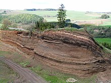
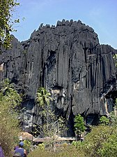
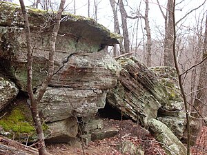
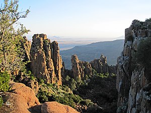
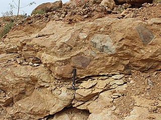
An outcrop or rocky outcrop is a visible exposure of bedrock or ancient superficial deposits on the surface of the Earth. [1]
This article needs additional citations for verification .(September 2011) |
An outcrop or rocky outcrop is a visible exposure of bedrock or ancient superficial deposits on the surface of the Earth. [1]
Outcrops do not cover the majority of the Earth's land surface because in most places the bedrock or superficial deposits are covered by soil and vegetation and cannot be seen or examined closely. However, in places where the overlying cover is removed through erosion or tectonic uplift, the rock may be exposed, or crop out. Such exposure will happen most frequently in areas where erosion is rapid and exceeds the weathering rate such as on steep hillsides, mountain ridges and tops, river banks, and tectonically active areas. In Finland, glacial erosion during the last glacial maximum (ca. 11000 BC), followed by scouring by sea waves, followed by isostatic uplift has produced many smooth coastal and littoral outcrops.
Bedrock and superficial deposits may also be exposed at the Earth's surface due to human excavations such as quarrying and building of transport routes.
Outcrops allow direct observation and sampling of the bedrock in situ for geologic analysis and creating geologic maps. In situ measurements are critical for proper analysis of geological history and outcrops are therefore extremely important for understanding the geologic time scale of earth history. Some of the types of information that cannot be obtained except from bedrock outcrops or by precise drilling and coring operations, are structural geology features orientations (e.g. bedding planes, fold axes, foliation), depositional features orientations (e.g. paleo-current directions, grading, facies changes), paleomagnetic orientations. Outcrops are also very important for understanding fossil assemblages, and paleo-environment, and evolution as they provide a record of relative changes within geologic strata.
Accurate description, mapping, and sampling for laboratory analysis of outcrops made possible all of the geologic sciences and the development of fundamental geologic laws such as the law of superposition, the principle of original horizontality, principle of lateral continuity, and the principle of faunal succession.
On Ordnance Survey maps in Great Britain, cliffs are distinguished from outcrops: cliffs have a continuous line along the top edge with lines protruding down; outcrops have a continuous line around each area of bare rock. An outcrop example in California is the Vasquez Rocks, familiar from location shooting use in many films, composed of uplifted sandstone. [2] [3] Yana is another example of outcrops, located in Uttara Kannada district in Karnataka, India.


Erosion is the action of surface processes that removes soil, rock, or dissolved material from one location on the Earth's crust and then transports it to another location where it is deposited. Erosion is distinct from weathering which involves no movement. Removal of rock or soil as clastic sediment is referred to as physical or mechanical erosion; this contrasts with chemical erosion, where soil or rock material is removed from an area by dissolution. Eroded sediment or solutes may be transported just a few millimetres, or for thousands of kilometres.

Till or glacial till is unsorted glacial sediment.

Geomorphology is the scientific study of the origin and evolution of topographic and bathymetric features generated by physical, chemical or biological processes operating at or near Earth's surface. Geomorphologists seek to understand why landscapes look the way they do, to understand landform and terrain history and dynamics and to predict changes through a combination of field observations, physical experiments and numerical modeling. Geomorphologists work within disciplines such as physical geography, geology, geodesy, engineering geology, archaeology, climatology, and geotechnical engineering. This broad base of interests contributes to many research styles and interests within the field.
Landforms are categorized by characteristic physical attributes such as their creating process, shape, elevation, slope, orientation, rock exposure, and soil type.
The Llano Uplift is a geologically ancient, low geologic dome that is about 90 miles (140 km) in diameter and located mostly in Llano, Mason, San Saba, Gillespie, and Blanco counties, Texas. It consists of an island-like exposure of Precambrian igneous and metamorphic rocks surrounded by outcrops of Paleozoic and Cretaceous sedimentary strata. At their widest, the exposed Precambrian rocks extend about 65 miles (105 km) westward from the valley of the Colorado River and beneath a broad, gentle topographic basin drained by the Llano River. The subdued topographic basin is underlain by Precambrian rocks and bordered by a discontinuous rim of flat-topped hills. These hills are the dissected edge of the Edwards Plateau, which consist of overlying Cretaceous sedimentary strata. Within this basin and along its margin are down-faulted blocks and erosional remnants of Paleozoic strata which form prominent hills.

The Baltic Shield is a segment of the Earth's crust belonging to the East European Craton, representing a large part of Fennoscandia, northwestern Russia and the northern Baltic Sea. It is composed mostly of Archean and Proterozoic gneisses and greenstone which have undergone numerous deformations through tectonic activity. It contains the oldest rocks of the European continent with a thickness of 250–300 km.
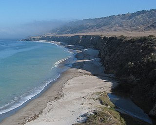
A raised beach, coastal terrace, or perched coastline is a relatively flat, horizontal or gently inclined surface of marine origin, mostly an old abrasion platform which has been lifted out of the sphere of wave activity. Thus, it lies above or under the current sea level, depending on the time of its formation. It is bounded by a steeper ascending slope on the landward side and a steeper descending slope on the seaward side. Due to its generally flat shape, it is often used for anthropogenic structures such as settlements and infrastructure.

The geology of Great Britain is renowned for its diversity. As a result of its eventful geological history, Great Britain shows a rich variety of landscapes across the constituent countries of England, Wales and Scotland. Rocks of almost all geological ages are represented at outcrop, from the Archaean onwards.

The geology of the Grand Teton area consists of some of the oldest rocks and one of the youngest mountain ranges in North America. The Teton Range, partly located in Grand Teton National Park, started to grow some 9 million years ago. An older feature, Jackson Hole, is a basin that sits aside the range.
Tectonic uplift is the geologic uplift of Earth's surface that is attributed to plate tectonics. While isostatic response is important, an increase in the mean elevation of a region can only occur in response to tectonic processes of crustal thickening, changes in the density distribution of the crust and underlying mantle, and flexural support due to the bending of rigid lithosphere.

Glacial landforms are landforms created by the action of glaciers. Most of today's glacial landforms were created by the movement of large ice sheets during the Quaternary glaciations. Some areas, like Fennoscandia and the southern Andes, have extensive occurrences of glacial landforms; other areas, such as the Sahara, display rare and very old fossil glacial landforms.

A joint is a break (fracture) of natural origin in a layer or body of rock that lacks visible or measurable movement parallel to the surface (plane) of the fracture. Although joints can occur singly, they most frequently appear as joint sets and systems. A joint set is a family of parallel, evenly spaced joints that can be identified through mapping and analysis of their orientations, spacing, and physical properties. A joint system consists of two or more intersecting joint sets.

The geology of England is mainly sedimentary. The youngest rocks are in the south east around London, progressing in age in a north westerly direction. The Tees–Exe line marks the division between younger, softer and low-lying rocks in the south east and the generally older and harder rocks of the north and west which give rise to higher relief in those regions. The geology of England is recognisable in the landscape of its counties, the building materials of its towns and its regional extractive industries.

The geology of Kansas encompasses the geologic history and the presently exposed rock and soil. Rock that crops out in the US state of Kansas was formed during the Phanerozoic eon, which consists of three geologic eras: the Paleozoic, Mesozoic and Cenozoic. Paleozoic rocks at the surface in Kansas are primarily from the Mississippian, Pennsylvanian, and Permian periods.

The interaction between erosion and tectonics has been a topic of debate since the early 1990s. While the tectonic effects on surface processes such as erosion have long been recognized, the opposite has only recently been addressed. The primary questions surrounding this topic are what types of interactions exist between erosion and tectonics and what are the implications of these interactions. While this is still a matter of debate, one thing is clear, Earth's landscape is a product of two factors: tectonics, which can create topography and maintain relief through surface and rock uplift, and climate, which mediates the erosional processes that wear away upland areas over time. The interaction of these processes can form, modify, or destroy geomorphic features on Earth's surface.

New England is a region in the North Eastern United States consisting of the states Rhode Island, Connecticut, Massachusetts, New Hampshire, Vermont, and Maine. Most of New England consists geologically of volcanic island arcs that accreted onto the eastern edge of the Laurentian Craton in prehistoric times. Much of the bedrock found in New England is heavily metamorphosed due to the numerous mountain building events that occurred in the region. These events culminated in the formation of Pangaea; the coastline as it exists today was created by rifting during the Jurassic and Cretaceous periods. The most recent rock layers are glacial conglomerates.

The geology of Germany is heavily influenced by several phases of orogeny in the Paleozoic and the Cenozoic, by sedimentation in shelf seas and epicontinental seas and on plains in the Permian and Mesozoic as well as by the Quaternary glaciations.
The Edaga Arbi Glacials are a Palaeozoic geological formation in Tigray and in Eritrea. The matrix is composed of grey, black and purple clays, that contains rock fragments up to 6 metres across. Pollen dating yields a Late Carboniferous to Early Permian age.
The geology of national parks in Britain strongly influences the landscape character of each of the fifteen such areas which have been designated. There are ten national parks in England, three in Wales and two in Scotland. Ten of these were established in England and Wales in the 1950s under the provisions of the National Parks and Access to the Countryside Act 1949. With one exception, all of these first ten, together with the two Scottish parks were centred on upland or coastal areas formed from Palaeozoic rocks. The exception is the North York Moors National Park which is formed from sedimentary rocks of Jurassic age.
The geology of the Gower Peninsula in South Wales is central to the area's character and to its appeal to visitors. The peninsula is formed almost entirely from a faulted and folded sequence of Carboniferous rocks though both the earlier Old Red Sandstone and later New Red Sandstone are also present. Gower lay on the southern margin of the last ice sheet and has been a focus of interest for researchers and students in that respect too. Cave development and the use of some for early human occupation is a further significant aspect of the peninsula's scientific and cultural interest.
| Authority control databases: National |
|---|