Sandstone is a clastic sedimentary rock composed mainly of sand-sized silicate grains. Sandstones comprise about 20–25% of all sedimentary rocks.

Sedimentary rocks are types of rock that are formed by the accumulation or deposition of mineral or organic particles at the Earth's surface, followed by cementation. Sedimentation is the collective name for processes that cause these particles to settle in place. The particles that form a sedimentary rock are called sediment, and may be composed of geological detritus (minerals) or biological detritus. The geological detritus originated from weathering and erosion of existing rocks, or from the solidification of molten lava blobs erupted by volcanoes. The geological detritus is transported to the place of deposition by water, wind, ice or mass movement, which are called agents of denudation. Biological detritus was formed by bodies and parts of dead aquatic organisms, as well as their fecal mass, suspended in water and slowly piling up on the floor of water bodies. Sedimentation may also occur as dissolved minerals precipitate from water solution.

Sediment is a naturally occurring material that is broken down by processes of weathering and erosion, and is subsequently transported by the action of wind, water, or ice or by the force of gravity acting on the particles. For example, sand and silt can be carried in suspension in river water and on reaching the sea bed deposited by sedimentation; if buried, they may eventually become sandstone and siltstone through lithification.
Sedimentology encompasses the study of modern sediments such as sand, silt, and clay, and the processes that result in their formation, transport, deposition and diagenesis. Sedimentologists apply their understanding of modern processes to interpret geologic history through observations of sedimentary rocks and sedimentary structures.

Stratigraphy is a branch of geology concerned with the study of rock layers (strata) and layering (stratification). It is primarily used in the study of sedimentary and layered volcanic rocks. Stratigraphy has two related subfields: lithostratigraphy and biostratigraphy.

Conglomerate is a clastic sedimentary rock that is composed of a substantial fraction of rounded to subangular gravel-size clasts. A conglomerate typically contain a matrix of finer grained sediments, such as sand, silt, or clay, which fills the interstices between the clasts. The clasts and matrix are typically cemented by calcium carbonate, iron oxide, silica, or hardened clay.
Lithostratigraphy is a sub-discipline of stratigraphy, the geological science associated with the study of strata or rock layers. Major focuses include geochronology, comparative geology, and petrology.

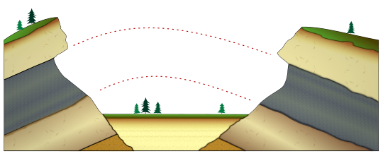
A marine transgression is a geologic event during which sea level rises relative to the land and the shoreline moves toward higher ground, which results in flooding. Transgressions can be caused by the land sinking or by the ocean basins filling with water or decreasing in capacity. Transgressions and regressions may be caused by tectonic events such as orogenies, severe climate change such as ice ages or isostatic adjustments following removal of ice or sediment load.
Relative dating is the science of determining the relative order of past events, without necessarily determining their absolute age. In geology, rock or superficial deposits, fossils and lithologies can be used to correlate one stratigraphic column with another. Prior to the discovery of radiometric dating in the early 20th century, which provided a means of absolute dating, archaeologists and geologists used relative dating to determine ages of materials. Though relative dating can only determine the sequential order in which a series of events occurred, not when they occurred, it remains a useful technique. Relative dating by biostratigraphy is the preferred method in paleontology and is, in some respects, more accurate. The Law of Superposition, which states that older layers will be deeper in a site than more recent layers, was the summary outcome of 'relative dating' as observed in geology from the 17th century to the early 20th century.

Mudrocks are a class of fine-grained siliciclastic sedimentary rocks. The varying types of mudrocks include siltstone, claystone, mudstone, slate, and shale. Most of the particles of which the stone is composed are less than 1⁄16 mm and are too small to study readily in the field. At first sight, the rock types appear quite similar; however, there are important differences in composition and nomenclature.
In geology, the term Torridonian is the informal name for the Torridonian Group, a series of Mesoproterozoic to Neoproterozoic arenaceous and argillaceous sedimentary rocks, which occur extensively in the Northwest Highlands of Scotland. The strata of the Torridonian Group are particularly well exposed in the district of upper Loch Torridon, a circumstance which suggested the name Torridon Sandstone, first applied to these rocks by James Nicol. Stratigraphically, they lie unconformably on gneisses of the Lewisian complex and their outcrop extent is restricted to the Hebridean Terrane.

The Bouma Sequence describes a classic set of sedimentary structures in turbidite beds deposited by turbidity currents at the bottoms of lakes, oceans and rivers.

Clastic rocks are composed of fragments, or clasts, of pre-existing minerals and rock. A clast is a fragment of geological detritus, chunks and smaller grains of rock broken off other rocks by physical weathering. Geologists use the term clastic with reference to sedimentary rocks as well as to particles in sediment transport whether in suspension or as bed load, and in sediment deposits.

In geology, a graded bed is one characterized by a systematic change in grain or clast size from one side of the bed to the other. Most commonly this takes the form of normal grading, with coarser sediments at the base, which grade upward into progressively finer ones. Normally graded beds generally represent depositional environments which decrease in transport energy as time passes, but these beds can also form during rapid depositional events. They are perhaps best represented in turbidite strata, where they indicate a sudden strong current that deposits heavy, coarse sediments first, with finer ones following as the current weakens. They can also form in terrestrial stream deposits.

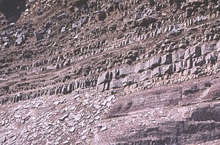
Beds are the layers of sedimentary rocks that are distinctly different from overlying and underlying subsequent beds of different sedimentary rocks. Layers of beds are called strata. They are formed from sedimentary rocks being deposited on the Earth's solid surface over long periods of time. The strata are layered in the same order that they were deposited, permitting discrimination as to which beds are younger and which ones are older. The structure of a bed is determined by its bedding plane, the surface that separates two layers. Beds can be differentiated in various ways, such as by particle size or rock or mineral type. The term is generally applied to sedimentary strata, but may also be used for volcanic flows or ash layers.
Cyclic sediments are sequences of sedimentary rocks that are characterised by repetitive patterns of different rock types (strata) or facies within the sequence. Processes that generate sedimentary cyclicity can be either autocyclic or allocyclic, and can result in piles of sedimentary cycles hundreds or even thousands of metres thick. The study of sequence stratigraphy was developed from controversies over the causes of cyclic sedimentation.
This glossary of geology is a list of definitions of terms and concepts relevant to geology, its sub-disciplines, and related fields. For other terms related to the Earth sciences, see Glossary of geography terms.
A dish structure is a type of sedimentary structure formed by liquefaction and fluidization of water-charged soft sediment either during or immediately following deposition. Dish structures are most commonly found in turbidites and other types of clastic deposits that result from subaqueous sediment gravity flows.
Iron-rich sedimentary rocks are sedimentary rocks which contain 15 wt.% or more iron. However, most sedimentary rocks contain iron in varying degrees. The majority of these rocks were deposited during specific geologic time periods: The Precambrian, the early Paleozoic, and the middle to late Mesozoic. Overall, they make up a very small portion of the total sedimentary record.

The Southern Oklahoma Aulacogen(ah-lah-coh-jin) (help·info) is a failed rift, or failed rift arm (aulacogen), of the triple junction that became the Iapetus Ocean spreading ridges. It is a significant geological feature in the Western and Southern United States. It formed sometime in the early to mid Cambrian Period and spans the Wichita Mountains, Taovayan Valley, Anadarko Basin, and Hardeman Basin in Southwestern Oklahoma. The Southern Oklahoma Aulacogen is primarily composed of basaltic dikes, gabbros, and units of granitic rock.