Geology is a branch of natural science concerned with Earth and other astronomical objects, the features or rocks of which it is composed, and the processes by which they change over time. Modern geology significantly overlaps all other Earth sciences, including hydrology, and so is treated as one major aspect of integrated Earth system science and planetary science.

Sedimentary rocks are types of rock that are formed by the accumulation or deposition of mineral or organic particles at Earth's surface, followed by cementation. Sedimentation is the collective name for processes that cause these particles to settle in place. The particles that form a sedimentary rock are called sediment, and may be composed of geological detritus (minerals) or biological detritus. The geological detritus originated from weathering and erosion of existing rocks, or from the solidification of molten lava blobs erupted by volcanoes. The geological detritus is transported to the place of deposition by water, wind, ice or mass movement, which are called agents of denudation. Biological detritus was formed by bodies and parts of dead aquatic organisms, as well as their fecal mass, suspended in water and slowly piling up on the floor of water bodies. Sedimentation may also occur as dissolved minerals precipitate from water solution.
Sedimentology encompasses the study of modern sediments such as sand, silt, and clay, and the processes that result in their formation, transport, deposition and diagenesis. Sedimentologists apply their understanding of modern processes to interpret geologic history through observations of sedimentary rocks and sedimentary structures.

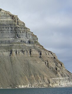
Stratigraphy is a branch of geology concerned with the study of rock layers (strata) and layering (stratification). It is primarily used in the study of sedimentary and layered volcanic rocks. Stratigraphy has three related subfields: lithostratigraphy, biostratigraphy, and chronostratigraphy.
Historical geology or palaeogeology is a discipline that uses the principles and methods of geology to reconstruct the geological history of Earth. Historical geology examines the vastness of geologic time, measured in billions of years, and investigates changes in the Earth, gradual and sudden, over this deep time. It focuses on geological processes, such as plate tectonics, that have changed the Earth's surface and subsurface over time and the use of methods including stratigraphy, structural geology, paleontology, and sedimentology to tell the sequence of these events. It also focuses on the evolution of life during different time periods in the geologic time scale.

An unconformity is a buried erosional or non-depositional surface separating two rock masses or strata of different ages, indicating that sediment deposition was not continuous. In general, the older layer was exposed to erosion for an interval of time before deposition of the younger layer, but the term is used to describe any break in the sedimentary geologic record. The significance of angular unconformity was shown by James Hutton, who found examples of Hutton's Unconformity at Jedburgh in 1787 and at Siccar Point in 1788.
The law of superposition is an axiom that forms one of the bases of the sciences of geology, archaeology, and other fields pertaining to geological stratigraphy. In its plainest form, it states that in undeformed stratigraphic sequences, the oldest strata will lie at the bottom of the sequence, while newer material stacks upon the surface to form new deposits over time. This is paramount to stratigraphic dating, which requires a set of assumptions, including that the law of superposition holds true and that an object cannot be older than the materials of which it is composed. To illustrate the practical applications of superposition in scientific inquiry, sedimentary rock that has not been deformed by more than 90° will exhibit the oldest layers on the bottom, thus enabling paleontologists and paleobotanists to identify the relative ages of any fossils found within the strata, with the remains of the most archaic lifeforms confined to the lowest. These findings can inform the community on the fossil record covering the relevant strata, to determine which species coexisted temporally and which species existed successively in perhaps an evolutionarily or phylogenetically relevant way.

In structural geology, a fold is a stack of originally planar surfaces, such as sedimentary strata, that are bent or curved during permanent deformation. Folds in rocks vary in size from microscopic crinkles to mountain-sized folds. They occur as single isolated folds or in periodic sets. Synsedimentary folds are those formed during sedimentary deposition.

Stratigraphy is a key concept to modern archaeological theory and practice. Modern excavation techniques are based on stratigraphic principles. The concept derives from the geological use of the idea that sedimentation takes place according to uniform principles. When archaeological finds are below the surface of the ground, the identification of the context of each find is vital in enabling the archaeologist to draw conclusions about the site and about the nature and date of its occupation. It is the archaeologist's role to attempt to discover what contexts exist and how they came to be created. Archaeological stratification or sequence is the dynamic superimposition of single units of stratigraphy, or contexts.
Lithostratigraphy is a sub-discipline of stratigraphy, the geological science associated with the study of strata or rock layers. Major focuses include geochronology, comparative geology, and petrology.
Relative dating is the science of determining the relative order of past events, without necessarily determining their absolute age. In geology, rock or superficial deposits, fossils and lithologies can be used to correlate one stratigraphic column with another. Prior to the discovery of radiometric dating in the early 20th century, which provided a means of absolute dating, archaeologists and geologists used relative dating to determine ages of materials. Though relative dating can only determine the sequential order in which a series of events occurred, not when they occurred, it remains a useful technique. Relative dating by biostratigraphy is the preferred method in paleontology and is, in some respects, more accurate. The Law of Superposition, which states that older layers will be deeper in a site than more recent layers, was the summary outcome of 'relative dating' as observed in geology from the 17th century to the early 20th century.

Cross-cutting relationships is a principle of geology that states that the geologic feature which cuts another is the younger of the two features. It is a relative dating technique in geology. It was first developed by Danish geological pioneer Nicholas Steno in Dissertationis prodromus (1669) and later formulated by James Hutton in Theory of the Earth (1795) and embellished upon by Charles Lyell in Principles of Geology (1830).

In geology, cross-bedding, also known as cross-stratification, is layering within a stratum and at an angle to the main bedding plane. The sedimentary structures which result are roughly horizontal units composed of inclined layers. The original depositional layering is tilted, such tilting not being the result of post-depositional deformation. Cross-beds or "sets" are the groups of inclined layers, which are known as cross-strata.

In geology, a graded bed is one characterized by a systematic change in grain or clast size from one side of the bed to the other. Most commonly this takes the form of normal grading, with coarser sediments at the base, which grade upward into progressively finer ones. Such a bed is also described as fining upward. Normally graded beds generally represent depositional environments which decrease in transport energy as time passes, but these beds can also form during rapid depositional events. They are perhaps best represented in turbidite strata, where they indicate a sudden strong current that deposits heavy, coarse sediments first, with finer ones following as the current weakens. They can also form in terrestrial stream deposits.

In geology, a bed is a layer of sediment, sedimentary rock, or pyroclastic material "bounded above and below by more or less well-defined bedding surfaces". Specifically in sedimentology, a bed can be defined in one of two major ways. First, Campbell and Reineck and Singh use the term bed to refer to a thickness-independent layer comprising a coherent layer of sedimentary rock, sediment, or pyroclastic material bounded above and below by surfaces known as bedding planes. By this definition of bed, laminae are small beds that constitute the smallest (visible) layers of a hierarchical succession and often, but not always, internally comprise a bed.
This glossary of geology is a list of definitions of terms and concepts relevant to geology, its sub-disciplines, and related fields. For other terms related to the Earth sciences, see Glossary of geography terms.
Sedimentary structures include all kinds of features in sediments and sedimentary rocks, formed at the time of deposition.

The geologic record in stratigraphy, paleontology and other natural sciences refers to the entirety of the layers of rock strata. That is, deposits laid down by volcanism or by deposition of sediment derived from weathering detritus. This includes all its fossil content and the information it yields about the history of the Earth: its past climate, geography, geology and the evolution of life on its surface. According to the law of superposition, sedimentary and volcanic rock layers are deposited on top of each other. They harden over time to become a solidified (competent) rock column, that may be intruded by igneous rocks and disrupted by tectonic events.

A stratigraphic column is a representation used in geology and its subfield of stratigraphy to describe the vertical location of rock units in a particular area. A typical stratigraphic column shows a sequence of sedimentary rocks, with the oldest rocks on the bottom and the youngest on top.
Geological perspective correlation is a theory in geology describing geometrical regularities in the layering of sediments. Seventy percent of the Earth's surface are occupied by sedimentary basins – volumes consisted of sediments accumulated during million years, and alternated by long interruptions in sedimentation (hiatuses). The most noticeable feature of the rocks, which filled the basins, is layering (stratification). Stratigraphy is a part of Geology that investigates the phenomenon of layering. It describes the sequence of layers in the basin as consisted of stratigraphic units. Units are defined on the basis of their lithology and have no clear definition. Geological Perspective Correlation (GPC) is a theory that divided the geological cross-section in units according strong mathematical rule: all borders of layers in this unit obey the law of perspective geometry.
Sedimentation layers are mainly created in shallow waters of oceans, seas, and lakes. As new layers are deposited the old ones are sinking deeper due to the weight of accumulating sediments. The content of sedimentary layers, their order in the sequence, and geometrical characteristics keep records of the history of the Earth, of past climate, sea-level and environment. Most knowledge about the sedimentary basins came from exploration drilling when searching for oil and gas. The essential feature of this information is that each layer is penetrated by the wells in a number of scattered locations. This raises the problem of identifying each layer in all wells – the geological correlation problem The identification is based on comparison of 1) physical and mineralogical characteristics of the particular layer (lithostratigraphy), or 2) petrified remnants in this layer (biostratigraphy). The similarity of layers is decreasing as the distance between the cross-sections increases that leads to ambiguity of the correlation scheme that indicates which layers penetrated at different locations belong to the same body. To improve the results geologists take in consideration the spatial relations between layers, which restricted the number of acceptable correlations. The first restriction was formulated in XVII century: the sequence of layers is the same in any cross-section. The second one was discovered by Haites in 1963: In an undisturbed sequence of layers (strata) the thicknesses of any layer observed in two different locations obey the law of perspective geometry, i.e. the perspective ratio K = H1/H2 is the same for all layers in this succession. This theory attracted attention around the world., and particularly in Russia The theory is also a basis of the method of graphical correlation in biostratigraphy widely used in oil and coal industries.