Military geology

Last updated
Geologists with the USGS Military Geology Unit working on maps during World War II. Ruth A. M. Schmidt is in the center. Women USGS geologists working with maps during WWII.jpg
Geologists with the USGS Military Geology Unit working on maps during World War II. Ruth A. M. Schmidt is in the center.

Military geology is the application of geological theory to warfare and the peacetime practices of the military. The formal practice of military geology began during the Napoleonic Wars; however, geotechnical knowledge has been applied since the earliest days of siege warfare. [1] [2] [3] In modern warfare military geologists are used for terrain analysis, engineering, and the identification of resources. Military geologists have included both specially trained military personnel and civilians incorporated into the military. The peacetime application of military geology includes the building of infrastructure, typically during local emergencies or foreign peacekeeping deployments. [1]

Contents

Warfare can change the physical geology. Examples of this include artillery shattering the bedrock on the Western Front during World War I [4] and the detonation of nuclear weapons creating new rock types. [5] Military research has also led to many important geological discoveries.

Terrain analysis

Brancaster beach in England was used for amphibious tank practice as its sand was similar to that of Normandy. Brancaster beach - geograph.org.uk - 852227.jpg
Brancaster beach in England was used for amphibious tank practice as its sand was similar to that of Normandy.
The U.S. Army Corps of Engineers drilling a well in Cameroon as part of the "Civic Action" project US Army drilling well in Cameroon 2.jpg
The U.S. Army Corps of Engineers drilling a well in Cameroon as part of the "Civic Action" project
Trinitite (in green) produced by the Trinity Nuclear Test Trinitite on site.jpg
Trinitite (in green) produced by the Trinity Nuclear Test

Geologists have been employed since the Napoleonic Wars to provide an analysis of terrain which was expected to become a war theater, both in case of an upcoming battle and to assess the difficulty of logistical supply. [3] [7] [8] Academically, it has been found that battles are likely to occur on rocks of Permian, Triassic, or Upper Carboniferous age, possibly due to their typical relief and drainage. [9] More practically, geology has been used in identifying the best Allied invasion sites during World War II, including those in North Africa, Italy, and France. [9] This included studying the properties of the sand of Normandy beaches, the tolerance of the soil in the hinterland to bombardment, the sediment of the English Channel sea floor, [10] and the occurrence of landslides in Sicily. [9] Likewise, German geologists created maps of southern England for Operation Sea Lion, identifying quarry locations and the suitability of rock types to excavate trenchers, etc. [11]

In the Demilitarized Zone between North and South Korea, very rugged terrain is due to the structure of metamorphic rocks, while the best flat land is underlain by granite. During the Korean War, these flat areas were used as military staging grounds by the North Koreans. It has been suggested that an understanding of the fracture and foliation patterns of the metamorphic rocks could help a field commander. [12]

This field partially overlaps with military geography. For this reason the British Army employed geographers in this role until the end of 1941, when it joined international common practice and started using geologists. [9]

Geotechnical engineering

Geologists have been involved in the construction of forts, tunnels, and bunkers both during military conflicts and in peacetime. [1] [13] This included digging tunnels in northeastern Italy and Austria during the so-called mine war in World War I. The rocks of the Dolomites are different from those in other theaters and specialists were required in order to design the tunnels. Explosives were then put in the tunnels and detonated, to cause rock falls and undercut enemy troops. [13] [14]

Geology is also used in determining the likely resistance of enemy defenses to shelling and bombing. [15] In World War II, this task was performed by the Allies as they advanced across German-occupied Europe, assessing the likely effect of bombing bridges and shelling defenses in light of the local geology. [9] During peacetime, similar methods have been used, such as the decision to locate the American Strategic Petroleum Reserve in the salt domes of the Gulf Coast. [16]

Resource acquisition

Geologists are used to determine both the location and accessibility of strategic and tactical resources during war. [1] [17] In the case of the D Day landings and the 2003 invasion of Iraq, ground water and aggregate were the two most important geological resources to identify for the campaign. The aggregate was required both for roading metal and for the construction of airfields. [17] [18] Since 1966, the German Army has also been using geologists to mitigate and predict the environmental effects of civilian resource extraction. [19]

Forensics

Simplification of GeoRef citations of military geology papers. Note the increase for the two world wars. [1]

Geology has been used in many military intelligence investigations. During World War II, the American Military Geology Unit discovered the origin of balloon bombs which had been dispatched towards North America from Japan. They accomplished this by determining from which beach the sand in the balloon's ballast originated. [20] Knowledge of rock types and seismic propagation also allows geologists to distinguish between natural and nuclear test initiated earthquakes. [3]

Effect of warfare on rocks

Military activity affects the physical geology. This was first noted through the intensive shelling on the Western Front during World War I, which caused the shattering of the bedrock and changed the rocks' permeability. [4] New minerals, rocks, and land-forms are also a byproduct of nuclear testing. [5]

Discoveries by military

Military research has led to many geological discoveries; however, secrecy has often delayed some of the possible progress. [21] The Austrian Army of World War I included geologists called Kriegsgeologen who were allowed to carry out non-military scientific investigation during the war. [13] [14] Discoveries have included new natural resource deposits [22] and the mapping of magnetic stripes on the ocean floor, leading to the idea of plate tectonics. [21]

See also

Related Research Articles

<span class="mw-page-title-main">Geology</span> Scientific study of the composition, structure, and history of Earth

Geology is a branch of natural science concerned with the Earth and other astronomical objects, the rocks of which they are composed, and the processes by which they change over time. Modern geology significantly overlaps all other Earth sciences, including hydrology. It is integrated with Earth system science and planetary science.

<span class="mw-page-title-main">Schist</span> Easily split medium-grained metamorphic rock

Schist is a medium-grained metamorphic rock showing pronounced schistosity. This means that the rock is composed of mineral grains easily seen with a low-power hand lens, oriented in such a way that the rock is easily split into thin flakes or plates. This texture reflects a high content of platy minerals, such as mica, talc, chlorite, or graphite. These are often interleaved with more granular minerals, such as feldspar or quartz.

<span class="mw-page-title-main">Taconic orogeny</span> Mountain-building period that affected most of New England

The Taconic orogeny was a mountain building period that ended 440 million years ago (Ma) and affected most of modern-day New England. A great mountain chain formed from eastern Canada down through what is now the Piedmont of the east coast of the United States. As the mountain chain eroded in the Silurian and Devonian periods, sediment spread throughout the present-day Appalachians and midcontinental North America.

The Military Geology Unit was a unit in the United States military during World War II. It was established on June 24, 1942, six months after Pearl Harbor. People in the US Geological Survey wanted to get involved in the war effort, either for patriotism or prestige or both, and provided a geological intelligence report for a randomly chosen country, Sierra Leone.

<span class="mw-page-title-main">Great Unconformity</span> Gap in geological strata

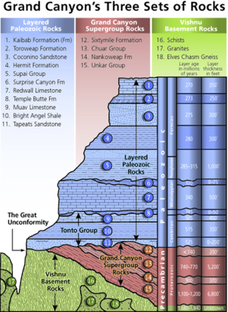
Of the many unconformities (gaps) observed in geological strata, the term Great Unconformity is frequently applied to either the unconformity observed by James Hutton in 1787 at Siccar Point in Scotland, or that observed by John Wesley Powell in the Grand Canyon in 1869. Both instances are exceptional examples of where the contacts between sedimentary strata and either sedimentary or crystalline strata of greatly different ages, origins, and structure represent periods of geologic time sufficiently long to raise great mountains and then erode them away.

<span class="mw-page-title-main">Hans Cloos</span> German geologist

Hans Cloos was a prominent German structural geologist.

Marland Pratt Billings was an American structural geologist who was considered one of the greatest authorities on North American geology. Billings was Professor of Geology at Harvard University for almost his entire career, having joined the faculty in 1930 and retired to emeritus status in 1972. He also taught for a brief time at Bryn Mawr College.

<span class="mw-page-title-main">Franciscan Complex</span> Late Mesozoic terrane of heterogeneous rocks in the California Coast Ranges

The Franciscan Complex or Franciscan Assemblage is a geologic term for a late Mesozoic terrane of heterogeneous rocks found throughout the California Coast Ranges, and particularly on the San Francisco Peninsula. It was named by geologist Andrew Lawson, who also named the San Andreas fault that defines the western extent of the assemblage.

<span class="mw-page-title-main">Fissility (geology)</span> Tendency of a rock to split along flat planes of weakness

In geology, fissility is the ability or tendency of a rock to split along flat planes of weakness. These planes of weakness are oriented parallel to stratification in sedimentary rocks. Fissility is differentiated from scaly fabric in hand sample by the parting surfaces’ continuously parallel orientations to each other and to stratification. Fissility is distinguished from scaly fabric in thin section by the well-developed orientation of platy minerals such as mica. Fissility is the result of sedimentary or metamorphic processes.

<span class="mw-page-title-main">Francis Birch (geophysicist)</span> American geophysicist

Albert Francis Birch was an American geophysicist. He is considered one of the founders of solid Earth geophysics. He is also known for his part in the atomic bombing of Hiroshima and Nagasaki.

<span class="mw-page-title-main">Wilmot Hyde Bradley</span> American geologist (1899–1979)

Wilmot Hyde Bradley was an American geologist who served as Chief Geologist of the U.S. Geological Survey from 1944 to 1959, and as President of the Geological Society of America in 1965. He was the tenth Chief Geologist, and his tenure was the longest of any Chief Geologist at the time.

Ragged Staff Cave is a cave bordering the harbour in the British Overseas Territory of Gibraltar. The cave was converted into Ragged Staff Magazine in 1901.

David Samuel Tucker is a geologist, author, and union organizer in Washington state. He is a research associate at Western Washington University. He was an instructor at North Cascades Institute, and the director of the Mount Baker Volcano Research Center. He writes the blog Northwest Geology Field Trips, a blog aimed at laypeople detailing where to find interesting geology in the Pacific Northwest. In 2015, he published a popular book on Washington geology, Geology Underfoot in Western Washington. He resides in Bellingham, Washington. In the 1980s he worked as a mountaineering guide in the Cascades, Mexico, and South America.

<span class="mw-page-title-main">Mount Luyendyk</span> Mountain in Marie Byrd Land, Antarctica

Mount Luyendyk is a summit in the western Fosdick Mountains of the Ford Ranges of Marie Byrd Land, West Antarctica. It forms a prominent exposure in the northwestern Iphigene massif. The peak is named in recognition of Bruce P. Luyendyk, professor (emeritus), University of California, Santa Barbara, who was active in ground- and ocean-based Antarctic research from 1989 to 2015, significantly advancing the scientific knowledge of the Ross Embayment region of Antarctica. Luyendyk led two on-land expeditions in the Ford Ranges, and was principal investigator for five marine geophysical expeditions in the Ross Sea.

<span class="mw-page-title-main">Geologists Seamounts</span> Group of seamounts in the Pacific Ocean mainly south of Hawaii

Geologists Seamounts are a cluster of seamounts in the Pacific Ocean, located mainly 100 miles (160 km) south of Oahu, Hawaii and 100–200 kilometres (62–124 mi) south-west from Big Island (Hawaiʻi). Clockwise from north they are named Perret, Jaggar, McCall, Pensacola, Daly, Swordfish, Cross, Washington and Ellis. The Kauluakalana seamount to the north of Oahu on the far side of the Hawaiian chain to the other seamounts of the cluster, and south-east of the Musicians Seamounts has reason to be regarded as part of the Geologists Seamounts, but would not so be grouped logically by the former name for the cluster.

<span class="mw-page-title-main">Siemon Muller</span> American paleontologist

Siemon William Muller was an American paleontologist and geologist, known for his studies on Triassic paleontology and stratigraphy, and for his work on permafrost.

Meers Fault is a fault in Oklahoma that extends from Kiowa County to Comanche County. It is marked by a 22–26 kilometers (14–16 mi) long conspicuous fault scarp but the fault extends beyond the ends of this scarp. The Meers fault is part of a group of faults that lie between the Anadarko Basin and the Wichita Mountains.

<span class="mw-page-title-main">Brevard Fault</span> Geological feature in the eastern United States

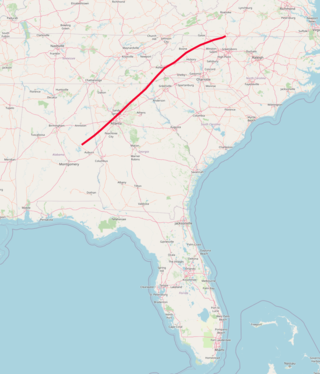
The Brevard Fault Zone is a 700-km long and several km-wide thrust fault that extends from the North Carolina-Virginia border, runs through the north metro Atlanta area, and ends near Montgomery, Alabama. It is an important Paleozoic era feature in the uplift of the Appalachian Mountains.

<span class="mw-page-title-main">Concord Gabbro-Syenite Complex</span> Geologic formation in North Carolina

The Concord Gabbro-Syenite Complex is a paleozoic pluton located in North Carolina.

<span class="mw-page-title-main">Leopoldo Pilla</span> Italian geologist, veterinarian, physician

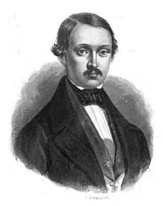
Leopoldo Pilla was an Italian geologist, veterinarian, and physician. He contributed to studies on volcanoes. He died in the Risorgimento while leading a student regiment during the Battle of Curtatone.

References

  1. 1 2 3 4 5 James R. Underwood, Jr. Peter L. Guth (1998). "Military Geology in War and Peace". Geological Society of America. 13. ISSN   0080-2018.
  2. Erdmann, C. E. (1943). "Application of geology to the principles of war". Geological Society of America Bulletin. 54 (8): 1169–1194. Bibcode:1943GSAB...54.1169E. doi:10.1130/GSAB-54-1169. ISSN   0016-7606.
  3. 1 2 3 Kiersch, George A.; Underwood, James R. (1998). "Geology and military operations, 1800–1960: An overview". Military Geology in War and Peace. Reviews in Engineering Geology. Vol. 13. pp. 5–28. doi:10.1130/REG13-p5. ISBN   0-8137-4113-0. ISSN   0080-2018.
  4. 1 2 Bressan, David (2014). "Battlefield Earth – the Geological Legacy of War". blogs.scientificamerican.com.
  5. 1 2 Eby, Nelson; Hermes, Robert; Charnley, Norman; Smoliga, John A. (2010). "Trinitite—the atomic rock". Geology Today. 26 (5): 180–185. Bibcode:2010GeolT..26..180E. doi: 10.1111/j.1365-2451.2010.00767.x . ISSN   1365-2451.
  6. "BRANCASTER BEACH - WWII Heritage". www.worldwar2heritage.com. Retrieved 2019-04-26.
  7. Rose, Edward P. F.; Nathanail, C. Paul (2000). Geology and Warfare: Examples of the Influence of Terrain and Geologists on Military Operations. Geological Society of London. ISBN   9781862390652.
  8. Kiersch, George A. (1998). "Engineering geosciences and military operations". Engineering Geology. 49 (2): 123–176. Bibcode:1998EngGe..49..123K. doi: 10.1016/S0013-7952(97)00080-X . ISSN   0013-7952.
  9. 1 2 3 4 5 Andrews, Robin. "Meet The Covert Geologists That Helped The Allies Win The Second World War". Forbes. Retrieved 2019-04-23.
  10. Rose, Edward P. F.; Pareyn, Claude (1998). British applications of military geology for 'Operation Overlord' and the battle in Normandy, France, 1944. Reviews in Engineering Geology. Vol. 13. pp. 55–66. doi:10.1130/REG13-p55. ISBN   0-8137-4113-0. ISSN   0080-2018.
  11. Rose, Edward P. F.; Ehlen, Judy; Lawrence, Ursula L. (2019). "Military use of geologists and geology: a historical overview and introduction". Geological Society, London, Special Publications. 473 (1): 1–29. Bibcode:2019GSLSP.473....1R. doi: 10.1144/SP473.15 . ISSN   0305-8719. S2CID   135118323.
  12. Cameron, C. P. (1998). "Dearly bought ridges, steep access valleys, and staging grounds: The military geology of the eastern DMZ, central Korean Peninsula". Military Geology in War and Peace. Reviews in Engineering Geology. Vol. 13. pp. 83–98. doi:10.1130/REG13-p83. ISBN   0-8137-4113-0. ISSN   0080-2018.
  13. 1 2 3 Bressan, David. "War Geology" . Retrieved 2019-04-22.
  14. 1 2 Macleod, Roy (2009). "' Kriegsgeologen and practical men': military geology and modern memory, 1914–18". The British Journal for the History of Science. 28 (4): 427. doi:10.1017/S0007087400033483. ISSN   0007-0874. S2CID   131282816.
  15. Eastler, Thomas E.; Percious, Donald J.; Fisher, Paul R. (1998). "Role of geology in assessing vulnerability of underground fortifications to conventional weapons attack". Military Geology in War and Peace. Reviews in Engineering Geology. Vol. 13. pp. 173–188. doi:10.1130/REG13-p173. ISBN   0-8137-4113-0. ISSN   0080-2018.
  16. Neal, James T. (1998). "Swords into plowshares: Military geology and national security projects" (PDF). Military Geology in War and Peace. Reviews in Engineering Geology. Vol. 13. pp. 111–116. doi:10.1130/REG13-p111. ISBN   0-8137-4113-0. ISSN   0080-2018.
  17. 1 2 Knowles, Robert B.; Wedge, William K. (1998). "Military geology and the Gulf War". Military Geology in War and Peace. Reviews in Engineering Geology. Vol. 13. pp. 117–124. doi:10.1130/REG13-p117. ISBN   0-8137-4113-0. ISSN   0080-2018. S2CID   5341529.
  18. Rose, Edward P. F.; Pareyn, Claude (1998). British applications of military geology for 'Operation Overlord' and the battle in Normandy, France, 1944. Reviews in Engineering Geology. Vol. 13. pp. 55–66. doi:10.1130/REG13-p55. ISBN   0-8137-4113-0. ISSN   0080-2018.
  19. Rose, Edward P. F.; Nathanail, C. Paul (2000). Geology and Warfare: Examples of the Influence of Terrain and Geologists on Military Operations. Geological Society of London. ISBN   9781862390652.
  20. "Japanese Vengeance Balloon Bombs of World War II - J. David Rogers". web.mst.edu. Retrieved 2019-04-25.
  21. 1 2 Weisberger, Mindy; December 13, Senior Writer; ET, 2018 08:15am (13 December 2018). "US Navy's Secrecy Likely Stalled Ocean Science Progress for Decades". Live Science. Retrieved 2019-04-23.{{cite web}}: CS1 maint: numeric names: authors list (link)
  22. Neal, James T. (1998). "Swords into plowshares: Military geology and national security projects" (PDF). Military Geology in War and Peace. Reviews in Engineering Geology. Vol. 13. pp. 111–116. doi:10.1130/REG13-p111. ISBN   0-8137-4113-0. ISSN   0080-2018.