Uttara Kannada

Last updated

Uttara Kannada/North Canara District
Kanur, Karnataka 581337, India - panoramio (11).jpg
A pic in Murudeswara.jpeg
Banavasi1.jpg
Bridge, Sadashivghad (1496158).jpg
Om Beach, Gokarna (Sunset).jpg
Clockwise from top-left:Sathodi Falls in Kanur, Murudeshwar Temple, Kali River Bridge at Karwar, Om Beach at Gokarna, Madhukesvara Temple at Banavasi
Nickname: 
Kashmir of Karnataka
Karnataka UK locator map.svg
Uttara Kannada
Coordinates: 14°36′N74°42′E / 14.6°N 74.7°E / 14.6; 74.7
CountryFlag of India.svg  India
State Karnataka
Division Kitturu Karnataka
Region Malenadu & Karavali
Established1 November 1956
Talukas Karwar, Ankola, Kumta, Honnavar, Bhatkal, Sirsi, Siddapur, Yellapur, Mundgod, Haliyal, Joida, Dandeli
Government
  District MinisterShrinivas poojari
  Zilla Panchayat PresidentJayashri M
   MP Ananth Kumar Hegde
  DCGangu Bai Ramesh Manakar, IAS
Area
  Total10,291 km2 (3,973 sq mi)
  Rank5th
Elevation
Average
600 m (2,000 ft)
Population
 (2011) [1]
  Total1,437,169
  Rank 20th
  Density140/km2 (400/sq mi)
Languages
  Spoken Kannada, Konkani, Marathi
Time zone UTC+5:30 (IST)
PIN
581xxx
Telephone code+91 0(838x)
ISO 3166 code IN-KA
Vehicle registration
Coastline142 kilometres (88 mi)
Literacy84.06%
Lok Sabha constituency Uttara Kannada Lok Sabha constituency
Climate Monsoon (Köppen)
Precipitation 2,835 millimetres (111.6 in)
Avg. summer temperature33 °C (91 °F)
Avg. winter temperature20 °C (68 °F)
Website uttarakannada.nic.in

Uttara Kannada is a district in the Indian state of Karnataka. It is a major coastal district of Karnataka, and is the third largest district in Karnataka. It is bordered by the state of Goa and Belagavi districts to the north, Dharwad District and Haveri District to the east, Shivamogga District, and Udupi District to the south, and the Laccadive Sea to the west.

Contents

Karwar is the district headquarters, Kumta and Sirsi are the major commercial centers in the district.

The district's agroclimatic divisions include the coastal plain (consisting of Karwar, Ankola, Kumta, Honnavar and Bhatkal taluks) and Malenadu (consisting of Sirsi, Siddapur, Yellapur, Haliyal, Joida, and Mundgod taluks).

History

Chaturmukha Basadi, Gerusoppa constructed by Rani Chennabhairadevi,considered to be longest reigning Pepper queen. Chaturmukha basadi, Gerusoppa (cropped).jpg
Chaturmukha Basadi, Gerusoppa constructed by Rani Chennabhairadevi,considered to be longest reigning Pepper queen.
Kodlamane Shree Vishnumurthy Temple Kodlamane Vishnumurthy Temple.jpg
Kodlamane Shree Vishnumurthy Temple
Kali River & Sadashivgad Fort as seen from Nandangadda Village. Sadashivgad Fort & Kali Bridge as seen from Nandangadda Village.jpg
Kali River & Sadashivgad Fort as seen from Nandangadda Village.

The first known dynasty from Uttara Kannada District are Chutus of Banavasi. Uttara Kannada was the home of the Kadamba kingdom from the 350 to 525. They ruled from Banavasi. After the subjugation of the Kadambas by the Chalukyas, the district came under successive rule of empires like Chalukyas, Rashtrakutas, Hoysalas and Vijayanagar empire. Moroccan traveler Ibn Battuta is said to have stayed for a time in the district under the protection of Nawayath Sultan Jamal Al-Din at Hunnur. [3] This place is presently known as Hosapattana and is located in the town of Honnavar. Ruins of an old mosque and its minaret can still be seen in the village. The district came under the rule of Maratha Empire in the 1750s and later part of Mysore Kingdom, who ceded it to the British at the conclusion of the Fourth Mysore War in 1799. It was initially part of Kanara district in Madras Presidency. The district was divided to North and South Kanara districts in 1859. The British finally transferred Uttara Kannada district to Bombay Presidency in 1862.

After India's independence in 1947, Bombay Presidency was reconstituted as Bombay State. In 1956, the southern portion of Bombay State was added to Mysore State, which was renamed Karnataka in 1972.

Significant and picturesque, the Sadashivgad fort of historical importance is now a tourist destination located by the Kali river bridge, which has been built at the confluence of the river and the Arabian Sea. The renowned Bengali poet and Nobel laureate Rabindranath Tagore, who visited Uttara Kannada in 1882, dedicated an entire chapter of his memoirs to this town. [4] The 22-year-old Rabindranath Tagore stayed with his brother, Satyendranath Tagore, who was the district judge in Uttara Kannada. There is a substantial amount of Chardo families in this area as they had migrated due to the persecution of the Portuguese in Goa.

Portuguese

Cintacora, also known as Chittakula, and Sindpur, were Portuguese and Chittakula was known to them as a very old port. When the fort of Sadashivgad was built in this area, the village also came to be known by that name. Pir fort, named for the Dargah of Shah Karamuddin, was captured and burnt by the Portuguese in 1510. The creek at the mouth of the Kali River was a trading center which came into great prominence after Sadashivgad was built and the Portuguese realized the advantages of its sheltered harbour.

British

In 1638, a rival English trading body, the Courteen Association, established a factory at Uttara Kannada (actually the village named Kadwad, situated 6 kilometres (3.7 mi) eastwards on the banks of the Kali river). It was a trade port frequented by traders from Arabia and Africa. Baitkhol port (the current civil port of Uttara Kannada) was known for its natural harbour. The name Baithkhol is Arabic term, Bait-e-kol, meaning bay of safety. Muslin was the chief commodity purchased but Uttara Kannada was also a source for pepper, cardamom, cassia and coarse blue cotton cloth. Situated on India's west coast, 50 miles south-east of Goa, Uttara Kannada was noted for its safe harbour. In 1649, the Courteen Association united with the British East India Company and Uttara Kannada became a company factory.

North Kanara, 1896 North Kanara 1896.jpg
North Kanara, 1896

Kingdom of Mysore

In the Treaty of Mangalore signed in 1784, between Tipu Sultan and the East India Company, one finds reference to Uttara Kannada and Sadashivgad written as Karwar and Sadasewgude respectively. [5]

Bhatkal and Honnavar were the chief ports of Tippu Sultan in the district.

The British Empire

The British made Carwar the district headquarters of North Canara in 1862. Since 1862, the time from which it came under Bombay presidency, Uttara Kannada was described as a first rate harbour between Bombay and Colombo.

Maratha Empire

It became a part of Maratha territory. It was a part of the Bombay Presidency until 1950.

Geography and climate

Karwar evening Karwar Evening.jpg
Karwar evening

The main geographic feature of the district is the Western Ghats or Sahyadri range, which runs from north to south through the district. Between the Sahyadris and the sea is a narrow coastal strip, known as the Payanghat, which varies from 8 to 24 kilometres (5.0 to 14.9 mi) in width. Behind the coastal plain are flat-topped hills from 60 to 100 meters in height, and behind the hills are the ridges and peaks of the Sahyadris. East of the Sahyadris is the Balaghat upland, part of the vast Deccan plateau. Moisture-bearing winds come from the west, and yearly rainfall averages 3,000 millimetres (120 in) on the coast, and as high as 5,000 millimetres (200 in) on the west-facing slopes of the Sahyadris. East of the crest is the rain shadow of the Sahyadris, which receive as little as 1,000 millimetres (39 in) annually. Much of the rain falls in the June–September monsoon. Four major rivers drain westwards from the crest of the Sahyadris to the sea; from north to south, they are the Kali, Gangawali, Aghanashini, Sharavati. These rivers form numerous waterfalls, The river Aghanashini drops 116 meters, Magod Falls, where the Bedti river plunges 180 meters in two leaps, Shivganga falls, where the river Sonda (Shalmali) drops 74 meters, and Lalguli falls and Mailmane falls on the river Kali. In the lowlands, these rivers form wide estuaries, extending several kilometers inland from the coast.

Ecology

Candy corn plant in the Anshi National Park Wagatea spicata.jpg
Candy corn plant in the Anshi National Park

The district's high rainfall supports lush forests, which cover approximately 70% of the district. The Malabar Coast moist forests ecoregion lies in a narrow strip between the Arabian Sea and the foothills of the Western Ghats up to 250 meters elevation. These forests have been almost completely converted to agriculture and teak plantations. The North Western Ghats moist deciduous forests cover the Sahyadris from 250 to 1000 meters elevation. Many trees shed leaves in the drier months. Above 1000 meters elevation lie the evergreen North Western Ghats montane rain forests. Anshi National Park near Dandeli, preserves approximately 250 square kilometres (97 sq mi) of semi-evergreen forest, which is home to the tiger, black panther, leopard cat, gaur, Asian elephant, sambar and a range of birds and reptiles. Dandeli Wildlife Sanctuary protects 834 square kilometres (322 sq mi) of semi-evergreen and bamboo forest in the watershed of the Kali river and its tributaries, the Kaneri and Nagajhari. Wroughton's free-tailed bat (Otomops wroughtoni) is endemic to the forests of Bhimgad Wildlife Sanctuary.

The district is also home to patches of savanna and degraded scrub jungles, which are often the result of overuse for logging or grazing. Much of the lowland has been cleared for agriculture. Mangrove forests can be found in the river estuaries, and the sandy beaches are home to groves of Calophyllum inophyllum , coconut and screw pine ( Pandanus ). The rocky beaches at Binaga, Arga, Belekeri, Tadadi, Gokarna, Ankola, Kumta, Dhareshwar, Kasarkod, Murdeshwara, Bhatkal and Belke of the district are rich with marine fauna diversity. The beaches at Bhatkal include American Jali Beach, Bahrain Jali Beach, NaStar Beach, Nakhuda Beach, Lighthouse Beach and the rocky Udmudey Beach. The rocky beaches of Uttara Kannada District harbor the invertebrates belonging to the phyla Porifera, Coelenterata, Annelida, Arthropoda, Mollusca and Echinodermata. Attiveri bird sanctuary is home to 79 species of birds including migratory birds from 22 countries.

Dandeli Wildlife Sanctuary is famous for the elusive black panther among other animals like gaur, tiger and leopards. The Kavala caves with their 5 feet (1.5 m). High natural Shiva linga, Synthery rocks is a 500 feet (150 m) high rock flanked by natural caves and waterfalls, Vincholi rapids, Sykes point which offers a view of Kali river, and a suspension bridge are places worth visiting in this sanctuary. Yana is an enchanting place that can be reached by trekking about 10 kilometres (6.2 mi) through lush forest. There is also a shrine of Bhairaveshvara here. Anshi National Park located some distance from Dandeli is undisturbed. Burude Falls is about 20 kilometres (12 mi) from Siddapur, Unchalli Falls, Shivagangae, BeeneHolae Fall is about 25 kilometres (16 mi) from Sirsi, Magod Falls and Sathodi Falls near Yellapura are some of the best natural falls in Uttara Kannada District. There are many dams in this district namely Supa Dam, Kodasalli Dam and Kadra Dam. The atomic energy station at Kaiga is on the banks of Kali River (Karnataka).

Economy

Uttara Kannada has a Gross Domestic District Product of 530297 Lakh Crores with Karwar and Sirsi being major contributors.sirsi has the highest per capita income in the district at 54850 followed by karwar at 44326, while Bhatkal and Haliyal have the lowest. [6]

Agriculture

The chief crops of the district are rice and areca nut, along with a great diversity of other crops. Tree crops include coconut, sugarcane, cocoa, cashew, mango, banana, pineapple, garcinia, jack fruit, and sapota; vegetables include onion, radish, cucumber, cauliflower, sweet potato, eggplant (brinjal), and amaranth; spices include pepper, cardamom, ginger and nutmeg. Millet and cotton are grown in the drier portion of the district east of the Western Ghats.

Bhatkal is known for its imported goods markets,[ citation needed ] which existed even before India's liberalisation.

Commerce and industry

Demographics

Historical population
YearPop.±% p.a.
1901454,722    
1911430,755−0.54%
1921401,928−0.69%
1931418,048+0.39%
1941441,388+0.54%
1951518,062+1.61%
1961689,862+2.91%
1971849,453+2.10%
19811,073,561+2.37%
19911,220,260+1.29%
20011,353,644+1.04%
20111,437,169+0.60%
source: [7]

According to the 2011 census, Uttara Kannada has a population of 1,437,169, [8] roughly equal to the nation of Eswatini [9] or the US state of Hawaii. [10] This gives it a ranking of 346th in India (out of a total of 640). [8] The district has a population density of 140 inhabitants per square kilometre (360/sq mi). Its population growth rate over the decade 2001–2011 was 6.15%. Uttara Kannada has a sex ratio of 975 females for every 1000 males. 29.15% of the population lives in urban areas. Scheduled Castes and Scheduled Tribes make up 8.10% and 2.39% of the population respectively. [8]

Religion

Religion in Uttara Kannada district (2011) [11]
ReligionPercent
Hinduism
82.61%
Islam
13.08%
Christianity
3.10%
Buddhism
0.89%
Other or not stated
0.32%

The population is predominantly Hindu, although a Catholic community has existed here since the 1500s. Muslims are a sizeable minority in Bhatkal Taluk and are majority in Bhatkal City. A small community of Tibetan refugees lives in Mundgod.

Language

Languages in Uttara Kannada district (2011). [12]

   Kannada (55.34%)
   Konkani (18.21%)
   Urdu (11.83%)
   Marathi (9.52%)
   Telugu (1.36%)
  Others (3.88%)

The main language spoken in this district is Kannada, spoken by 55.34%. Other major languages include Konkani at 18.21%, 11.83% Urdu, 9.52% Marathi and 1.36% Telugu. Marathi speakers are mostly located in Joida and Haliyal taluks in the north and Konkani is in majority in Karwar taluk, although it is spoken throughout the district in lesser numbers. Nawayathi is a Konkani dialect spoken by Nawayath Muslims in Bhatkal and surrounding areas. [12]

Kannada is understood by a vast majority of the population of Uttara Kannada, even by the Konkani speaking people; exceptions are the villages in the extreme north of the Karwar taluka such as Sadashivgad, Baval, Majali etc. where the native people do not understand Kannada as Konkani is dominant due to the close proximity of Goa. Kannada dialects spoken in the district include Achchagannada or Halakki Kannada spoken by Halakki Gowdas and Havigannada spoken by the Havyakas.

Literacy

Total about 10.8 lakh people in the district are literate, among them about 5.8 lakh are male and about 5 lakh are female. Literacy rate (children under 6 are excluded) of Uttara Kannada is 84%. 90% of male and 78% of female population are literate here. Overall literacy rate in the district has increased by 7%. Male literacy has gone up by 5% and female literacy rate has gone up by 10%.

RankTalukLiteracy
1 Sirsi 94%
2 Karwar 89%
3 Kumta 87%
4 Ankola 85%
5 Siddapur 85%
6 Honnavar 84%
7 Dandeli 83%
8 Bhatkal 83%
9 Yellapur 81%
10 Mundgod 80%
11 Joida 76%
12 Haliyal 74%

Culture

Costume of yakshaghana FullPagadeYakshagana.jpg
Costume of yakshaghana

Yakshagana is a classical dance drama popular in the state of Karnataka in India mostly popular in the districts of Uttara Kannada. Shimoga, Udupi, Dakshina Kannada and Kasaragod district of Kerala. This theater art involves music, songs, dance, acting, dialogue, story and unique costumes. While songs and dance adhere to well established talas very similar to Indian classical dance forms, acting and dialogues are created spontaneously on stage depending on ability of artists. This combination of classical and folk elements makes yakshagana unique from any other Indian art. This would be considered to be a form of opera in western eyes. Traditionally, yakshaganas use to start late in the night and run entire night. Bagavatha, the background singer is also the directory of the story and controls the entire proceedings on stage. Bagavatha along with background musicians who play chande and maddale forms himmela. The actors who wear colorful costumes and enact various roles in the story forms mummela. There are many professional troops in Karnataka. In spite of competition from modern movie industry and TV, these troops are arranging ticketed shows and making profit. Apart from this individuals arrange shows in their village inviting well known professional artists like Sri Chittani Ramachandra Hegde, Kondadakuli Ramachandra Hegde, Gopal Achari Theerthahalli and Ramesh Bhandari Murur, providing an opportunity for local talents to act with legends. Yakshagana is sometimes simply called as aataā in both Kannada and Khela (Karwari Konkani) Konkani (meaning play). [13] Yaksha-gana literally means the song (gana) of a yaksha. Yakshas were an exotic tribe mentioned in the Sanskrit literature of ancient India. [14] The Nawayath men wears lungis unique to them.

Cuisine

Batata Vada Batata Vada.jpg
Batata Vada

Uttara Kannada is famous for a variety of seafood delicacies. Fish curry and rice is the staple diet of the locals. Cashews and coconut are also extensively used.

The staple diet includes a portion of steamed rice with a vegetable and/or seafood accompaniment. Seafood is immensely popular due to its ease of availability, and is prepared with a lot of local spices. Tea is the most popular beverage and is sometimes supplemented with cardamom or mint to give a distinct flavour.

Transport

Public transport

North West Karnataka Transport Corporation (NWKRTC) is the state transport agency in the district. The NWKRTC covers all towns & villages of the district. There is a good network of public transport which connects the villages to the towns of the district. There are regular intra state services to major cities & towns of the state like Bangalore, Mangalore, Shimoga, Mysore, Hubli-Dharwad & Belgaum. The Kadama Transport buses of neighboring Goa state provides regular service from Karwar to Mangalore and all part of Goa state. Kumta, Bhatkal and Sirsi are the main hubs for public transport which provides services to intra-district & intrastate round the clock.

Many private transport buses also provide services for inter / intra state from the district. Bhatkal is the main sector for private transport in the district. The NH-66 which passes through the district which connects Panvel near Mumbai to Kerala state, many private buses are plying on this Highway which provides inter-intra state services to places like Bombay, Poona, Kolhapore, Belgaum, Panaji, Margao, Udupi, Mangalore, Bangalore, Mysore, Bhatkal, Kasaragod, Cannanore, Calicut etc.

Railways

The following Railways pass through the district:

Ports

Uttara Kannada being one of the coastal district of the Karnataka state has a coast of 120 kilometres (75 mi) has many ports which are used for sea trade, naval base, fishing and other maritime activities.

The Proposed Hubli-Ankola railway line can be feasible venture for the future developments of the ports in the district, for movement of the cargo, at present roads are only major mode of cargo movement which leads to congestion of the National Highways of the district.

Nearby airports

Tourist places

Uttara Kannada (North Kanara) has many tourist places which cater to different likes of the people. There are many religious places like Gokarna, Murudeshwar, Idagunji and Ulavi. The district (Jilla) has many beaches at Karwar, Gokarna, Bhavikeri near Ankola, Murdeshwar, Harawada, Kadle beach near Kumta, Handigon. Anshi National Park (Kali Tiger Reserve) is located in Uttara Kannada Jille. The backwaters of dams built across river Kali at Kadra, Thattihalla, Kodasalli, Supa and Bommanahalli provide splendid views in rainy season. There are many waterfalls in Uttar Kannada district Sathodi, Devkar, Emme shirle, Arebail, Benne Hole, U nchalli, Burude, Balepatte to name a few.

Notable personalities

Related Research Articles

<span class="mw-page-title-main">Konkan</span> Region of Southwest India

The Konkan is a stretch of land by the western coast of India, bound by the river Daman Ganga at Damaon in the north, to Anjediva Island next to Karwar town in the south; with the Arabian Sea to the west and the Deccan plateau to the east. The hinterland east of the coast has numerous river valleys, riverine islands and the hilly slopes known as the Western Ghats; that lead up into the tablelands of the Deccan. The region has been recognised by name, since at least the time of Strabo in the third century CE. It had a thriving mercantile port with Arab tradesmen from the 10th century. The best-known islands of Konkan are Ilhas de Goa, the site of the Goa state's capital at Panjim and the Seven Islands of Bombay, on which lies Mumbai, the capital of Maharashtra and the headquarters of Konkan Division.

<span class="mw-page-title-main">Kanara</span> Region in Karnataka, India

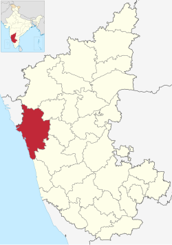
Kanara or Canara, also known as Karavali is the historically significant stretch of land situated by the southwestern coast of India, alongside the Arabian Sea in the present-day Indian state of Karnataka. The subregion comprises three civil districts, namely: Uttara Kannada, Udupi, and Dakshina Kannada. Kassergode was included prior to the States Reorganisation Act.

<span class="mw-page-title-main">Karwar</span> City in Karnataka, India

Karwar is a seaside city, taluka, and administrative headquarters of Uttara Kannada district lying at the mouth of the Kali river on the Kanara coast of Karnataka state, India.

Ankola is a Town Municipal Council and a taluka in Uttara Kannada district of the Indian state of Karnataka. The name of the place is derived from a forest shrub Ankola grown on the coastal hill side and worshiped by the Halakki Vokkaligas as a totem. The town is around 33 km (21 mi) from Karwar and 86 km (53 mi) from Sirsi.

<span class="mw-page-title-main">Kumta</span> Town in Karnataka

Kumta is a town and taluk in the Uttara Kannada district of Karnataka, India. It is one of the important stations along the Konkan Railway line running between Mumbai and Mangalore.

<span class="mw-page-title-main">Sirsi, Karnataka</span> City in Karnataka, India

Sirsi is a city and a taluk headquarter in Uttara Kannada district of Karnataka state in India. It was also known as Kalyana Pattana during the Sonda Dynasty. It is a tourist destination with evergreen forest and waterfalls and is also a commercial centre. The main businesses around the city are mostly subsistence and agriculture-based. Areca nut or betel nut, locally known as Adike, is the primary crop grown in the nearby villages, making it one of the major trading centres for areca nut. The region is also known for spices such as cardamom, pepper, betel leaves, and vanilla. The major food crop is paddy.

<span class="mw-page-title-main">Siddapur taluk</span> Taluk in Karnataka, India

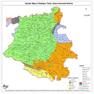
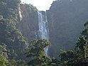
Siddapur Taluk is the destination of world famous Jog Falls. It is a part of Uttara Kannada district, Karnataka, India and is located in the midst of forest areas of Western Ghats and it is also a part of Malenadu. The taluk is full of greenery, hills and arecanut gardens developed in the valleys’. The taluk headquarters is Siddapur. Sirsi is the nearest city,

<span class="mw-page-title-main">Tourism in Karnataka</span> Overview of tourism in Karnataka, India

Karnataka, the sixth largest state in India, has been ranked as the third most popular state in the country for tourism in 2014. It is home to 507 of the 3600 centrally protected monuments in India, second only to Uttar Pradesh. The State Directorate of Archaeology and Museums protects an additional 752 monuments and another 25,000 monuments are yet to receive protection.

Karnataka's coastline called Karavali stretches 300 km between Mangalore in Dakshina Kannada district and Karwar in Uttara Kannada district. The coastline of Karnataka has been along the eastern shore of Arabian Sea. Karnataka has one major and ten minor ports in this coastal belt. Kali, Belekeri, Gangavali, Aghanashini Sharavathi, Sharabi, Kollur, Gangolli, Sitanadi, Gurpur and Netravati are the important rivers in this belt which empty into the Arabian sea. Sea erosion, migration of river mouths, siltation of ports and harbours are some of the problems common to this belt.

Joida is a town located in the Uttara Kannada district in the Indian state of Karnataka. The town is the headquarters of the eponymous taluk. Earlier it was known as Supa taluka but as Supa village got submerged due to dam built across river Kali, Joida taluka came into existence. Joida town has a Post office, branch of nationalised banks and a Police station.

<span class="mw-page-title-main">Kali River (Karnataka)</span> River in Karnataka, India

The Kali River or Kaali Nadi is a river flowing through Uttara Kannada district of Karnataka state in India. The river rises near Kushavali, a small village in Uttar Kannada district. The river is the lifeline to some 400,000 people in the Uttara Kannada district and supports the livelihoods of tens of thousands of people including fishermen on the coast of Karwar. There are many dams built across this river for the generation of electricity. One of the important dams build across Kali river is the Supa Dam at Ganeshgudi. The river runs 184 kilometers before joining Arabian Sea.

Bankikodla and Hanehalli are the twin neighbouring villages in a valley in Uttara Kannada district in the Indian state of Karnataka.

Majali is a hamlet in the Uttar Kannada district of Karnataka, India. It is situated in a coastal region called Kanara at the Goa-Karnataka border. The language spoken there are Konkani and Kannada.

<span class="mw-page-title-main">Tadadi</span> Village in Karnataka, India

Tadadi (Tadari) is one of the ports in Uttara Kannada, Karnataka, India. It is near Gokarna in Kumta taluk.

<span class="mw-page-title-main">Sadashivgad</span> Village located in Karwar District

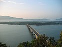
Sadashivgad is a village located in Karwar, Uttara Kannada district, in the state of Karnataka in India. Significant and picturesque, it is now a popular tourist destination located by the Kali river bridge, which has been built at the confluence of the river and the Arabian Sea.

Asnoti is a village in Karwar Taluka, Uttara Kannada district, Karnataka, India. It is close to the historic fort of Sadashivgad located on Kali river. Konkani is spoken as a local language.

<span class="mw-page-title-main">Outline of Karnataka</span> Overview of and topical guide to Karnataka

The following outline is provided as an overview of and topical guide to Karnataka:

Mudgeri is a village in Karwar Taluka, Uttara Kannada district, Karnataka, India. It is close to the historic fort of Sadashivgad located on Kali river. Konkani is spoken as a local language.

<span class="mw-page-title-main">Karwar railway station</span> Railway station in Karnataka, India

Karwar railway station is one of the main railway station in Uttara Kannada, Karnataka. Its code is KAWR. It is the headquarters of the Karwar Division of Konkan Railway(Pernem-Thokur). It serves Karwar city. The station consists of two platforms. Karwar has three nearby railway stations: Karwar, Asnoti and Harwada. A 1.69 km (1.05 mi) railway bridge on Kali River falls before Karwar Railway Station while travelling from the side of Goa. The town of Karwar is situated beside Kali River.

Chendia-Todur is a twin village in the Karwar Taluk of Uttar Kannada District of Karnataka. It lies 13 km south of the city of Karwar, 257 km north of the chief port city Mangalore and 489 km from the state capital Bangalore.

References

  1. "District Census 2011: Uttara Kannada" (PDF). Registrar General and Census Commissioner of India . Retrieved 17 February 2012.
  2. Chandra, Subhash (6 December 2020). "A new page: Reviving a piece of history". The New Indian Express .
  3. Ross E. Dunn; University Ross E Dunn (2005). The Adventures of Ibn Battuta: A Muslim Traveler of the Fourteenth Century. University of California Press. pp. 221–222. ISBN   978-0-520-24385-9.
  4. "My Reminiscences by Rabindranath Tagore: Ch. 37: Nature's Revenge – Uttara Kannada in Tagore's memoirs". online-literature.com. Retrieved 16 November 2022.
  5. "Project South Asia". Archived from the original on 20 July 2008. Retrieved 11 August 2009.
  6. Karnataka Directorate of Economics and Statistics https://des.kar.nic.in/sites/Conference%20Files/3%20Consolidated%20-%20All%20Articles%20-%20GDDP.pdf
  7. "Decadal Variation In Population Since 1901". censusindia.gov.in. Retrieved 16 November 2022.
  8. 1 2 3 "District Census Handbook: Uttara Kannada" (PDF). censusindia.gov.in. Registrar General and Census Commissioner of India. 2011.
  9. US Directorate of Intelligence. "Country Comparison:Population". Archived from the original on 13 June 2007. Retrieved 1 October 2011. Swaziland 1,436,847
  10. "2011 Resident Population Data". U. S. Census Bureau. Retrieved 30 September 2011. Hawaii 1,436,847
  11. "Table C-01 Population by Religion: Karnataka". censusindia.gov.in. Registrar General and Census Commissioner of India. 2011.
  12. 1 2 "Table C-16 Population by Mother Tongue: Karnataka". www.censusindia.gov.in. Registrar General and Census Commissioner of India.
  13. "Enduring art". The Hindu . Chennai, India. 10 June 2004. Archived from the original on 30 August 2004. Retrieved 6 September 2007.
  14. "yaksha". Encyclopædia Britannica. Retrieved 6 September 2007.