
Uttara Kannada is a district in the Indian state of Karnataka. It is a major coastal district of Karnataka, and is the third largest district in Karnataka. It is bordered by the state of Goa and Belagavi districts to the north, Dharwad District and Haveri District to the east, Shivamogga District, and Udupi District to the south, and the Arabian Sea to the west.

Mangalore, officially known as Mangaluru, is a major industrial port city in the Indian state of Karnataka and on the west coast of India. It is located between the Arabian Sea and the Western Ghats about 352 km (219 mi) west of Bangalore, the state capital, 14 km north of Karnataka–Kerala border and 297 km south of Goa. Mangalore is the state's only city to have all four modes of transport—air, road, rail and sea. The population of the urban agglomeration was 619,664 according to the 2011 national census of India. It is known for being one of the locations of the Indian strategic petroleum reserves.

The Konkan is a stretch of land by the western coast of India, bound by the Daman Ganga at Damaon in the north, to Anjediva Island next to Karwar town in the south; with the Arabian Sea to the west and the Deccan plateau in the east. The hinterland east of the coast has numerous river valleys and riverine islands among the hilly slopes leading up into the tablelands of the Deccan. The region has been recognised by name, since at least the time of Strabo in the third century C.E.. It had a thriving mercantile port with Arab tradesmen from the 10th century. The best-known islands of Konkan are Ilhas de Goa, the site of the Goa State's capital at Panjim, and the seven islands of Mumbai. Mumbai is the headquarters of the Konkan division, the capital of the State of Maharashtra, as well as India's financial centre.

Kanara or Canara, also known as Karavali is the historically significant stretch of land situated by the southwestern coast of India, alongside the Arabian Sea in the present-day Indian state of Karnataka. The subregion comprises three civil districts, namely: Uttara Kannada, Udupi, and Dakshina Kannada. Kassergode was included prior to the States Reorganisation Act.
Dakshina Kannada district is a district of Karnataka state in India, with its headquarters in the coastal city of Mangalore. It is part of the larger Tulu Nadu region. The district covers an area nestled in between the Western Ghats to its east and the Arabian Sea to its west. Dakshina Kannada receives abundant rainfall during the Indian monsoon. It is bordered by Udupi district to the north, Chikmagalur district to the northeast, Hassan district to the east, Kodagu to the southeast and Kasaragod district of Kerala to the south. According to the 2011 census of India, Dakshina Kannada district had a population of 2,083,625. It is the only district in Karnataka state to have all modes of transport like road, rail, water and air due to the presence of a major hub, Mangalore. This financial district is also known as the Cradle of Indian banking.
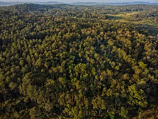
Malnad is a region in the state of Karnataka in India. Malenadu covers the western and eastern slopes of the Western Ghats or Sahyadri mountain range, and is roughly 100 kilometers in width. The region experiences heavy annual rainfall of 1000 to 3800 mm; it includes Agumbe, which receives the highest annual rainfall in Karnataka.

Yakshagana is a traditional theatre, developed in Dakshina Kannada, Udupi, Uttara Kannada, Shimoga and western parts of Chikmagalur districts, in the state of Karnataka and in Kasaragod district in Kerala that combines dance, music, dialogue, costume, make-up, and stage techniques with a unique style and form. It is believed to have evolved from pre-classical music and theatre during the period of the Bhakti movement. It is sometimes simply called "Aata" or āṭa. This theatre style is mainly found in coastal regions of Karnataka in various forms. Towards the south from Dakshina Kannada to Kasaragod of Tulu Nadu region, the form of Yakshagana is called Thenku thittu and towards the north from Udupi up to Uttara Kannada it is called Badaga thittu. Both of these forms are equally played all over the region.(Not sure about this one but) Yakshagana is traditionally presented from dusk to dawn. Its stories are drawn from Ramayana, Mahabharata, Bhagavata and other epics from both Hindu and Jain and other ancient Indic traditions.
Arebhashe or Aregannada or Gowda Kannada is a dialect of Kannada mainly by Gowda communities in the region Madikeri, Somwarpet, and Kushalnagar taluks of Kodagu district, Sullia, taluks of Dakshina Kannada district; Bangalore and Mysore districts in the Indian state of Karnataka. As well as Bandadka, Kasaragod District in the Indian state of Kerala, Arebhashe is also called Gowda Kannada. The language was recognized by the Karnataka State government and formed an academy in 2011 to preserve the culture and literature of the Arebhahse Region which is named as Karnataka Arebhashe Samskruthi mathu Sahitya Academy supported by then Chief Minister D. V. Sadananda Gowda.

Karwar is a seaside city, taluka, and administrative headquarters of Uttara Kannada district lying at the mouth of the Kali river on the Kanara coast of Karnataka state, India.

Karnataka, the sixth largest state in India, has been ranked as the third most popular state in the country for tourism in 2014. It is home to 507 of the 3600 centrally protected monuments in India, second only to Uttar Pradesh. The State Directorate of Archaeology and Museums protects an additional 752 monuments and another 25,000 monuments are yet to receive protection.
Karnataka's coastline called Karavali stretches 300 km between Mangalore in Dakshina Kannada district and Karwar in Uttara Kannada district. The coastline of Karnataka has been along the eastern shore of Arabian Sea. Karnataka has one major and ten minor ports in this coastal belt. Kali, Belekeri, Gangavali, Aghanashini Sharavathi, Sharabi, Kollur, Gangolli, Sitanadi, Gurpur and Netravati are the important rivers in this belt which empty into the Arabian sea. Sea erosion, migration of river mouths, siltation of ports and harbours are some of the problems common to this belt.
Joida is a town located in the Uttara Kannada district in the Indian state of Karnataka. The town is the headquarters of the eponymous taluk. Earlier it was known as Supa taluka but as Supa village got submerged due to dam built across river Kali, Joida taluka came into existence. Joida town has a Post office, branch of nationalised banks and a Police station.
Majali is a hamlet in the Uttar Kannada district of Karnataka, India. It is situated in a coastal region called Kanara at the Goa-Karnataka border. The language spoken there are Konkani and Kannada.
Amadalli is a village in the southern state of Karnataka, India. It is located in the Karwar taluk of Uttara Kannada district in Karnataka.

Kasarkod is a village in the southern state of Karnataka, India. It is located in the Honavar taluk of Uttara Kannada district in Karnataka.
The Komarpanth are a social group centred in and around Karwar Goa, komarpants used to primarily speak their own language, known as Halegannada along with Marathi and Konkani.
Karnataka is a state in the southern part of India. It was created on 1 November 1956, with the passing of the States Reorganisation Act. Karnataka is bordered by the Arabian Sea to the west, Goa to the north-west, Maharashtra to the north, Telangana and Andhra Pradesh to the east, Tamil Nadu to the south-east, and Kerala to the south-west. The state covers an area of 74,122 sq mi (191,976 km2), or 5.83% of the total geographical area of India. It comprises 30 districts. Kannada is the official language of Karnataka and as per the 2011 census is the mother tongue of 66.5% of the population. Various ethnic groups with origins in other parts of India have unique customs and use languages at home other than Kannada, adding to the cultural diversity of the state. Significant linguistic minorities in the state in 2011 included speakers of Urdu (10.8%), Telugu (5.8%), Tamil (3.5%), Marathi (3.4%), Hindi (3.2%), Tulu (2.6%), Konkani (1.3%) and Malayalam (1.3%).
Nandangadda is a coastal village located in Karwar Taluka of Uttara Kannada district, in the Indian state of Karnataka.

Apsarkonda is an emerging tourist village near Honnavar, in the district of Uttara Kannada, Karnataka, India. It is situated 8 km from the Honnavar bus stand.

Karwar Assembly constituency is one of the 224 Legislative Assembly constituencies of Karnataka state in India.


