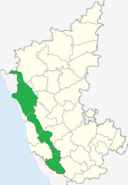
Uttara Kannada is a district in the Indian state of Karnataka. It is a major coastal district of Karnataka, and is the third largest district in Karnataka. It is bordered by the state of Goa and Belagavi districts to the north, Dharwad District and Haveri District to the east, Shivamogga District, and Udupi District to the south, and the Laccadive Sea to the west.

Shimoga, officially Shivamogga, is a city and the district headquarters of Shimoga district in the central part of the state of Karnataka, India. The city lies on the banks of the Tunga River. Being the gateway for the hilly region of the Western Ghats, the city is popularly nicknamed the "Gateway of Malnad". The population of Shimoga city is 322,650 as per 2011 census. The city has been selected for the Smart Cities project, standing in the fourth position in the state and 25th in the country as of November 2020.

Talakaveri or Talacauvery is the place that is generally considered to be the source of the river Kaveri and a holy place for many Hindus. It is located on Brahmagiri hills near Bhagamandala in Kodagu district (Coorg), in the South Indian state of Karnataka. It is located close to the border with Kasaragod district, Kerala. Talakaveri stands at a height of 1,276 meters above sea level. Despite its traditional status as the source of the Kaveri, there is no permanent visible flow from this place to the main rivercourse, except during the monsoon rains.

Chikmagalur, officially Chikkamagaluru is an administrative district in the Malnad subregion of Karnataka, India. Coffee was first cultivated in India in Chikmagalur. The hills of Chikmagalur are parts of the Western Ghats and the source of Tunga and Bhadra rivers. Mullayanagiri, the highest peak in Karnataka is located in the district. The area is well known for the Sringeri Mutt that houses the Dakshina Peeta established by Adi Shankaracharya.

Sharavati is a river which originates and flows entirely within the state of Karnataka in India. It is one of the few westward flowing rivers of India and a major part of the river basin lies in the Western Ghats. The famous Jog Falls, located about 25 km from Siddapura, is formed by this river. The river itself and the regions around it are rich in biodiversity and are home to many rare species of flora and fauna.

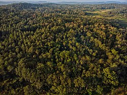
Agumbe is a village situated in the Thirthahalli taluka of Shivamogga district, Karnataka, India. It is nestled in the thickly forested Malenadu region of the Western Ghats mountain range. Owing to its high rainfall, it has received the epithet of "The Cherrapunji of South India", after Cherrapunji, one of the rainiest places in India.

Chikmagalur is a city and the headquarters of Chikmagalur district in the Indian state of Karnataka. Located on the foothills of the Mullayanagiri peak of the Western Ghats, the city attracts tourists from around the world for its pleasant and favourable hill station climate, tropical rainforest and coffee estates. The pristine Baba Budangiri lies to the north of Chikmagalur where it's believed Baba Budan first introduced coffee to India.

Hassan is one of the 31 districts of Karnataka, India. The district headquarter is Hassan. It was part of Manjarabad Faujdari a.k.a Patnada Rayada between 1832-81. In 1882, it was reduced into a sub-division under erstwhile Kadur district. But in 1886, the Hassan district was restored to its current form.

Shimoga district, officially known as Shivamogga district, is a district in the Karnataka state of India. A major part of Shimoga district lies in the Malnad region or the Sahyadri. Shimoga city is its administrative centre. Jog Falls view point is a major tourist attraction. As of 2011 Shimoga district has a population of 17,52,753. There are seven taluks: Soraba, Sagara, Hosanagar, Shimoga, Shikaripura, Thirthahalli, and Bhadravathi. Channagiri and Honnali were part of Shimoga district until 1997 when they became part of the newly formed Davanagere district.
Hosanagara is a panchayat town in Shimoga district in the Indian state of Karnataka. It is nested in western ghats of India. The World Cattle Conference with main emphasis on cow was held in month of April 2007 in Hosanagar. The different uses of cow were exhibited. Near Hosanagar there is a mutt named Sri Ramachandrapura Math, 6 km from the town.
Tarikere is a town, a taluk and is one of the two Subdivisional headquarter in the Chikmagalur district of Karnataka state, India. It is popularly known as gateway of Malnad because the Malnad area starts from here. The town's name is derived from the number of water tanks which surround it.

Karnataka, the sixth largest state in India, has been ranked as the third most popular state in the country for tourism in 2014. It is home to 507 of the 3600 centrally protected monuments in India, second only to Uttar Pradesh. The State Directorate of Archaeology and Museums protects an additional 752 monuments and another 25,000 monuments are yet to receive protection.

The Indian State of Karnataka is located between 11°30' North and 18°30' North latitudes and between 74° East and 78°30' East longitude.It is situated on a tableland where the Western Ghats and Eastern Ghats converge into the complex, in the western part of the Deccan Peninsular region of India. The State is bounded by Maharashtra and Goa States in the north and northwest; by the Lakshadweep Sea in the west; by Kerala in the south-west and Tamil Nadu in the south and south-east, Andhra Pradesh in the south-east and east and Telangana in the north-east. Karnataka extends to about 850 km (530 mi) from north to south and about 450 km (280 mi) from east to west.

Ghat Roads are access routes into the mountainous Western and Eastern Ghats, mountain ranges of the Indian subcontinent. These roads are remarkable feats of engineering, and most were constructed during the British Raj. Ghat Roads were built to connect to the hill stations established in the mountains for residents to avoid summer heat. They generally served to connect coastal areas with the upper Deccan Plateau.

The state of Karnataka in India experiences diverse rainfall quantities across its regions. While Malnad and Coastal Karnataka receive copious amount of rainfall; its north Bayaluseemae region in the Deccan Plateau is one of the most arid regions in the country. Most of the rains received in the state is during the monsoon season. Being an agrarian economy with a large percentage of its citizens engaged in agriculture, the failure of rains can have a crippling effect on the economy of the state. Apart from the benefits in agriculture, the Government of Karnataka has tried to avail other benefits of rainfall using scientific methods. An example of this is the project, Rainwater Harvesting in Rural Karnataka which is initiated by the Karnataka State Council for Science and Technology and is one of the largest rainwater harvesting projects in the world. Agumbe in the Shimoga district, Amagaon in Belgaum District, Hulikal again in Shimoga district and Talakaveri in Madikeri are some of the known places with the highest annual rainfall in South India. Of this Amagaon has received over 10000 mm rain fall twice in 10 years.
The Agumbe Rainforest Research Station (ARRS) is a field based conservation and research organisation situated inside the Agumbe Reserved Forest at Agumbe in the central Western Ghats of southern India. The Agumbe Reserved Forests receives an annual rainfall in excess of 7,000 mm (280 in) and is at an elevation of about 823 m (2,700 ft) above sea level. It forms a part of the Malnad-Kodagu corridor, which also includes the Someshwara, Mookambika, Bhadra, and Sharavati Wildlife Sanctuaries, Kudremukh National Park, and various other forest tracts and reserve forests around Kundapur, Shankaranarayana, Hosanagara, Sringeri, and Thirthahalli.
Amagaon is a village in Belagavi district bordered by Goa in west in the southern state of Karnataka, India. Amagaon nestles in the dense forests of the Western Ghats in and is known for its heavy rainfall. It is known to get over 10,000 mm annual rainfall occasionally and the average annual rainfall is around 9,000 mm. It is also called as Cherrapunji of South India

Hulikal is a village located in the Hosanagara taluk of the Shimoga district in the Indian state of Karnataka and is known for its heavy rainfall. The Hulikal village lies in western ghat region of Karnataka state. The range of ghat is known by the name Hulikal ghat or Balebare ghat. The road running between Hosangadi and Mastikatte through Hulikal ghati connects coastal district of Udupi with Shivamogga district. The Mani dam reservoir and Savehoklu reservoir are nearby. KPCL has its colony at Mastikatte near to Hulikal. The nearest airport is at Mangalore, situated 123 km south-west of Hulikal. It has an elevation of 600m.

Malnad Gidda or Malenadu Gidda is a dwarf breed of cattle native to the hilly, rainy and densely forested Malenadu region of the Western Ghats in the state of Karnataka in India. It is also known as Uradana (Kannada:ಊರದನ) and Varshagandhi (Kannada:ವರ್ಷಗಂಧಿ). They are of short stature and known for their adaptability, disease resistance. The milk and urine is of medicinal value. The cattle can also be sustained solely on grazing the forests and rural terrains. They are found to be of Black to brown complexions and are very active in temperament and are highly intelligent, also able to jump 5 feet fence. The breed which was once a non descript variety has now been declared officially as a distinct breed by the authorities. this cow commonly visible mainly in Shimoga, Chikkamangalore, Mangalore, hassan districts.
Ripponpeté is a small town located in Hosanagara Taluk, Shivamogga district, Karnataka, India.and it is center point of four taluks they are Shimoga sagara thirtahalli and hosanagra, the town is a gateway to the Malenadu (Malnad) region of India. Lord Ripon named as well the town of Riponpet in the Shivamogga district in the state of Karnataka. ,