
Ponmudi also known as Ooty of South Kerala, Kashmir of Kerala is a hill station in the Peringamala gramapanchayath of Trivandrum District of Kerala in India. It is located 22km west of Vithura town, 53 km north-east of Trivandrum City, 78 km south-east of Varkala town and 69 km north-east of Kovalam Beach at an altitude of 1,100 m (3,600 ft). Ponmudi (Varayadumotta) peak is a part of the Western Ghats mountain range that runs parallel to the Arabian Sea. Ponmudi is a popular honeymoon destination in South India. The normal temperature of Ponmudi is between 18 and 25 °C.

Kodachadri is a mountain peak with dense forests in the Western Ghats in South India, 78 km from Shimoga. Kodachadri is the highest peak in Shivamogga district. It is declared as natural heritage site by the Karnataka Government. and it is 13th highest peak of Karnataka.
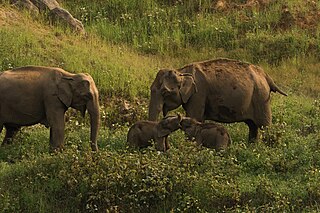
Anaimalai Tiger Reserve, earlier known as Indira Gandhi Wildlife Sanctuary and National Park and as Anaimalai Wildlife Sanctuary, is a protected area in the Anaimalai Hills of Pollachi and Valparai taluks of Coimbatore District and Udumalaipettai taluk in Tiruppur District, Tamil Nadu, India. The Tamil Nadu Environment and Forests Department by a notification dated 27 June 2007, declared an extent of 958.59 km2 that encompassed the erstwhile IGWLS&NP or Anaimalai Wildlife Sanctuary, as Anaimalai Tiger Reserve under the Wildlife Protection Act, 1972. According to the National Tiger Conservation Authority, the Reserve presently includes a core area of 958.59 km2 and buffer/peripheral area of 521.28 km2 forming a total area of 1479.87 km2.

Dudhsagar Falls is a four-tiered waterfall located on the Mandovi River in the Indian state of Goa. It is 60 km from Panaji by road and is located on the Belgaum–Vasco Da Gama rail route about 46 km east of Madgaon and 80 km south of Belgaum. Dudhsagar Falls is amongst India's tallest waterfalls with a height of 310 m (1017 feet) and an average width of 30 metres (100 feet).

Coimbatore district is one of the 38 districts in the state of Tamil Nadu in India. Coimbatore is the administrative headquarters of the district. It is one of the most industrialized districts and a major textile, industrial, commercial, educational, information technology, healthcare and manufacturing hub of Tamil Nadu. The region is bounded by Tiruppur district in the east, Nilgiris district in the north, Erode district in the north-east, Palakkad district, Idukki district and small parts of Thrissur district and Ernakulam district of neighboring state of Kerala in the west and south respectively. As of 2011, Coimbatore district had a population of 3,458,045 with a sex-ratio of 1,000 and literacy rate of 84%.
Pollachi is a town and a taluk headquarters in Coimbatore district, Tamil Nadu state, India. Located about 40 km (25 mi) to the south of Coimbatore, it is the second largest town in the district after Coimbatore. Pollachi is a popular Marketplace for jaggery, vegetables and cattle. As of 2011, the town had a population of 90,180.

Bhandardara is a holiday resort village near Igatpuri, in the western ghats of India. The village is located in the Akole tehsil, Ahmednagar district of the state of Maharashtra, about 185 kilometers (115 mi) from Mumbai and 155 kilometers (96 mi) from Ahmednagar.

Udumalai, also known as Udumalaipettai and Udumalpet, is a town in Tiruppur district in the Indian state of Tamil Nadu. Udumalaipettai is located 535 km south west from the state capital, Chennai and 72 km away from Coimbatore, the second largest city in the state.

Valparai is a Taluk and hill station in the Coimbatore district of Tamil Nadu, India. It consists of Anamalai Tiger Reserve. It is located 3,474 feet (1,059 m) above sea level on the Anaimalai Hills range of the Western Ghats. There are a total of 56 estates here. The game of football is very popular here. State level competitions are held every year. The foothill starts exactly from Monkey Falls which is at a distance of 38 kilometres (24 mi) to Valparai. The route to Valparai from the foothills consists of 40 hairpin bends. The Kerala state border town of Malakkappara is at a distance of 27 kilometres from Valparai. While major portions of the land are owned by private tea companies, large forest areas continue to be out of bounds.
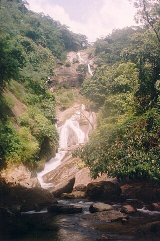
Siruvani Waterfalls and the dam named after them have located 36 km (22 mi) west of Coimbatore in the Western Ghats. The reservoir at Siruvani was built for Tamil Nadu by the Kerala government with funds collected by the Tamil Nadu government to meet the drinking water requirements of Coimbatore. The gateways on either side of the road across the dam are typical of the Kerala and Tamil architectural styles. Siruvani is also home to certain tribes like the Mudugars and Irulas. The view from the falls and the dam is a tourist attraction.

Thirumoorthy Temple is situated at the foot of the Thirumoorthy hills or Thirumoorthi hills adjoining the Thirumoorthy dam. The scenic beauty of the Anamalai hill range of Western Ghats, includes the cascading water to the Thirumoorthy reservoir from the Panchalingam Falls. A perennial stream flows by the side of the Sri Amanalingeswarar temple. The presiding deity is called Amanalingeswara.
Kottur-Malayandipattinam or Kottur is the biggest panchayat town in Anaimalai_taluk of Coimbatore rural district in the Indian state of Tamil Nadu. Its short name is KM Pattinam. The name Kottur-Malayandipattinam is used to distinguish it from other places of the same name in south India, with Malayandipattinam (malai-yandi-pattanam) being the name of the southern part of the town and named after being surrounded by western ghats. It is famous for buying elephant ivory 100 years before, kottur Tamil meaning of kottu is elephant ivory and it also means the end of town.
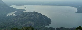
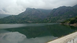
Aliyar ( Reservoir is a 6.48 km2 reservoir located in Aliyar village near Pollachi town in Coimbatore District, Tamil Nadu, South India. The dam is located in the foothills of Valparai, in the Anaimalai Hills of the Western Ghats. It is about 65 kilometres from Coimbatore. The dam offers some ideal getaways including a park, garden, aquarium, play area and a mini Theme-Park maintained by Tamil Nadu Fisheries Corporation for visitors enjoyment. The scenery is beautiful, with mountains surrounding three quarters of the reservoir. Boating is also available.
Ukkadam is a part of Townhall locality in the core part of the city of Coimbatore, Tamilnadu, India. Ukkadam Bus Terminal, which is one of the seven major bus stands in the city, is located in this neighborhood. Ukkadam is famous for its Fish Market, Jackfruit Market.
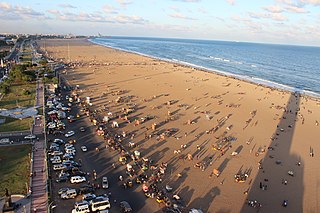
Tamil Nadu has the largest tourism industry in India with a percentage share of 21.31% and 21.86% of domestic and foreign tourist visits in the country. According to the 2020 Ministry of Tourism report, the number of domestic arrivals was at 494.8 million making the state the second most popular tourist destination in the country, and foreign arrivals numbered 6.86 million, the highest in the country, making it the most popular state for tourism in the country.

State Highway 21 or Chalakkudy-Malakkappara Road is a State Highway in Kerala, India that starts in Chalakudy and ends at the state boundary with Tamil Nadu at Malakkappara. The road where its majority of portion passes through Sholayar reservoir is 86.0 kilometres (53.4 mi) long. It passes through one of the most picturesque rainforests and is often described as one of the best scenic routes in India. The Athirappilly falls and Vazhachal falls are located on this route. It connects with Valparai-Pollachi Road in Tamil Nadu.

Bataan National Park is a protected area of the Philippines located in the mountainous interior of Bataan province in the Central Luzon Region. The park straddles the northern half of Bataan Peninsula near its border with Subic Bay Freeport Zone. The park was first established in 1945 under Proclamation No. 24 with an initial area of 31,000 hectares and included portions of the fenced area of Subic Bay Freeport Zone. The park was reduced in 1987 to its present size of 23,688 hectares and is now wholly located in Bataan province. The park encompasses the Bataan towns and cities of Hermosa, Orani, Samal, Abucay, Balanga, Bagac and Morong.
Aliyar is a village located near Pollachi Town in Coimbatore district in Tamil Nadu, India.
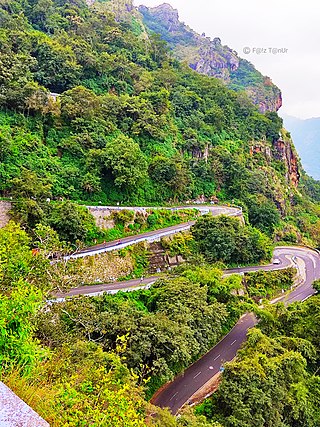
State Highway 78 or Valparai-Pollachi Road is a State Highway in Tamil Nadu, India that starts from Valparai and ends at the Pollachi. The 64-kilometre (40 mi) highway is often described by many as one of the best scenic routes in South India. There are 42 hairpin bends on this road. Monkey waterfalls and Aliyar waterfalls are located on this route. It connects with Valparai-Chalakudy road, another scenic route in South India.

