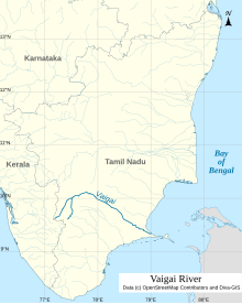
Madurai is a major city in the Indian state of Tamil Nadu. It is the cultural capital of Tamil Nadu and the administrative headquarters of Madurai District. As of the 2011 census, it was the third largest urban agglomeration in Tamil Nadu after Chennai and Coimbatore and the 33rd most populated city in India. Located on the banks of River Vaigai, Madurai has been a major settlement for two millennia and has a documented history of more than 2500 years. It is often referred to as "Thoonga Nagaram", meaning "the city that never sleeps".

Azhagar Kovil is a village in Madurai district in the South Indian state of Tamil Nadu. The history and living of the village is centered around Kallazhagar Temple. Constructed in the Dravidian style of architecture, the temple is glorified in the Nalayira Divya Prabandham, the early medieval Tamil canon of the Alvar saints from the 6th–9th centuries CE. It is one of the 108 Divya Desams dedicated to Vishnu, who is worshiped as Kallazhagar and his consort Lakshmi as Thirumamagal.

Theni is a valley town situated in the Indian state of Tamil Nadu at the foothills of Western Ghats. It is the headquarters of the Theni district, located at a distance of 70km from Madurai. It is known for the large-scale trading of garlic, cotton, cardamom, grapes, bananas, mango and chilli. It hosts the second largest weekly market in Tamil Nadu and the fourth largest in South India.

Pandya Nadu or Pandi Nadu is a geographical region comprising the southern part of the present day state of Tamil Nadu. The region is bounded on its West by the Venad/Ay Nadu, Northeast by the Chola Nadu and Northwest by the Kongu Nadu. It comprises the present-day districts of Madurai, Theni, Sivaganga, Ramanathapuram, Virudhunagar, Tirunelveli, Tenkasi, Thoothukudi, Kanniyakumari, parts of Pudukkottai and Dindigul.

The Palani Hills are a mountain range in the southern Indian states of Kerala and Tamil Nadu. The Palani Hills are an eastward extension of the Western Ghats ranges, which run parallel to the west coast of India. The Palani Hills adjoin with the high Anamalai range on the west and extend east into the plains of Tamil Nadu, covering an area of 2,068 square kilometres (798 sq mi). The highest part of the range is in the southwest, and reaches 1,800-2,500 metres elevation; the eastern extension of the range is made up of hills 1,000-1,500 m (3,281-4,921 ft) high.

Madurai district is one of the 38 districts of the state of Tamil Nadu in southeastern India. The city of Madurai serves as the district headquarters. It houses the famous Sri Meenakshi Sundareshwarar temple and is situated on the banks of the river Vaigai. Thiruparankundram is one of the major tourist place in the district. As of 2011, the district had a population of 3,038,252 with a sex-ratio of 990 females for every 1,000 males. Aside from the city of Madurai, the larger towns are Melur, Vadipatti, Thirumangalam, Thirupparankundram, Peraiyur, and Usilampatti. It is an important hub for various film shootings. Alanganallur is a popular spot in the district for Jallikattu, as are Palamedu and Avaniyapuram.

Periyar, IPA: [peɾijɐːr], is the longest river and the river with the largest discharge potential in the Indian state of Kerala. It is one of the few perennial rivers in the region and provides drinking water for several major towns. The Periyar is of utmost significance to the economy of Kerala. It generates a significant proportion of Kerala's electrical power via the Idukki Dam and flows along a region of industrial and commercial activity. The river also provides water for irrigation and domestic use throughout its course besides supporting a rich fishery. Due to these reasons, the river has been named the "Lifeline of Kerala". Kochi city, in the vicinity of the river mouth draws its water supply from Aluva, an upstream site sufficiently free of seawater intrusion. Twenty five percent of Kerala's industries are along the banks of river Periyar. These are mostly crowded within a stretch of 5 kilometres (3 mi) in the Eloor-Edayar region (Udhyogamandal), about 10 kilometres (6 mi) north of Kochi harbor.
The Paripādal is a classical Tamil poetic work and traditionally the fifth of the Eight Anthologies (Ettuthokai) in the Sangam literature. According to Tolkappiyam, Paripadal is a kind of verse dealing only with love (akapporul) and does not fall under the general classification of verses. It has a minimum of 25 lines and a maximum of 400 lines. It is an "akam genre", odd and hybrid collection which expresses love in the form of religious devotion (Bhakti) to gods and goddesses predominently to Maha Vishnu and Murugan. According to Kamil Zvelebil, a Tamil literature and history scholar. This is the only anthology in the Eight Anthologies collection that is predominantly religious, though the other seven anthologies do contain occasional mentions and allusions to gods, goddesses and legends.

Theni District is one of the 38 districts of Tamil Nadu state in India. Well protected by the scenic hill locks, the district is located besides Madurai district. The town of Theni is the district headquarters. The district is divided into two natural divisions: The hilly areas are constituted by parts of the five taluk's Theni, Bodinayakanur, Periyakulam, Uthamapalayam and Andipatti with thick vegetation and perennial streams from the hills on the western side and Cumbum valley which lies in Uthamapalayam taluk. As of 2011, Theni district had a population of 1,245,899 with a sex ratio of 980 females for every 1,000 males.

Andipatti or Aundipatty is a municipal body in Theni district in Madurai Region of Tamil Nadu state in southern India. It is on the bank of Vaigai River with rich flora and fauna species. It is a valley surrounded by mountains and there is a theory saying Western Ghats starts from this place.

Batlagundu is a town in Nilakottai block in Dindigul district in the Madurai Region state of Tamil Nadu, India. The name Vetrilaikkundru later transformed and changed to Vathalagundu. The town is the major gateway to Kodaikanal. Subramaniya Siva was a writer, Indian Freedom Fighter, and activist born in Batlagundu. Batlagundu is the fifth-largest town in the Dindigul district. The town is located in such a way connecting three main districts of South Tamil Nadu. Batlagundu has most of the voters in Nilakottai Constituency.
Cumbum, natively spelt as Kambam, is a town and municipality in Theni district, an Indian state of Tamil Nadu.
Sholavandan is a panchayat town in Madurai district in the Indian state of Tamil Nadu. It is located on the left bank of the Vaigai River, sixteen miles north west of Madurai. It is one of 12 "town- panchayats" of Madurai district.
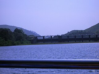
Mullaperiyar DamIPA: [mulːɐpːeɾijɐːr], is a masonry gravity dam on the Periyar River in the Indian state of Kerala It is located 881 m (2,890 ft) above the sea level, on the Cardamom Hills of the Western Ghats in Thekkady, Idukki District of Kerala, India. It was constructed between 1887 and 1895 by John Pennycuick and also reached in an agreement to divert water eastwards to the Madras Presidency area. It has a height of 53.6 m (176 ft) from the foundation, and a length of 365.7 m (1,200 ft). The Periyar National Park in Thekkady is located around the dam's reservoir. The dam is built at the confluence of Mullayar and Periyar rivers. The dam is located in Kerala on the river Periyar, but is operated and maintained by the neighbouring state of Tamil Nadu. Although the Periyar River has a total catchment area of 5398 km2 with 114 km2 downstream from the dam in Tamil Nadu, the catchment area of the Mullaperiyar Dam itself lies entirely in Kerala and thus not an inter-State river. On 21 November 2014, the water level hit 142 feet for first time in 35 years. The reservoir again hit the maximum limit of 142 feet on 15 August 2018, following incessant rains in the state of Kerala. In a UN report published in 2021, the dam was identified as one among the world's big dams which needs to be decommissioned for being 'situated in a seismically active area with significant structural flaws and poses risk to 3.5 million people if the 100+ years old dam were to fail'.

Koodal Aḻagar Temple in Madurai, a city in the South Indian state of Tamil Nadu, is dedicated to the Hindu god Vishnu. Constructed in the Dravidian style of architecture, the temple is glorified in the Naalayira Divya Prabandham, the early medieval Tamil canon of the Alvar saints from the 6th–9th centuries CE. It is one of the 108 Divya Desams dedicated to Vishnu, who is worshipped as Viyooga Sundarrajan, and his consort Lakshmi as Mathuravalli.
Meghamalai, commonly known as the High Wavy Mountains, is a mountain range located in the Western Ghats in the Theni district near Kumily, Tamil Nadu. It is dotted with cardamom plantations and tea plantations. The mountain range is 1,500 metres above sea level, and it is rich in flora and fauna. The area, now mostly planted with tea plants, includes cloudlands, high wavys, venniar, and the manalar estates belonging to the Woodbriar Group. Access is largely restricted and includes largely untouched remnants of evergreen forest.

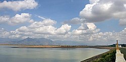
The Vaigai Dam is built across the Vaigai River near Andipatti, in the Theni district of Tamil Nadu, southern India. Near the dam, the Government of Tamil Nadu has constructed an Agricultural Research Station for researching the growing of a variety of crops, including rice, sorghum, blackgram, cowpea and cotton.

Colonel John PennycuickCSI was a British Army engineer and civil servant who served as a member of the Madras Legislative Council. He undertook several irrigation works which included the masonry dam of Mullaperiyar on the Periyar River.
Varusanadu is a village panchayat in Theni District of Tamil Nadu, which is located in the bank of Vaigai River. This village comes under Kadamalaigundu - Mayiladumparai Panchayat union and Andipatti Taluk.

KallalagarTemple is a Hindu temple dedicated to Vishnu in Alagar Koyil, a village in Madurai district in the South Indian state of Tamil Nadu. Constructed in the Dravidian style of architecture, the temple is glorified in the Naalayira Divya Prabandham, the early medieval Tamil canon of the Alvar saints from the 6th–9th centuries CE. It is one of the 108 Divya Desams dedicated to Vishnu, who is worshiped as Kallalagar, and his consort Lakshmi as Thirumagal. This temple is called as Thirumaliruncholai in Sangam literatures and Naalayira Divya Prabandham sung by Tamil Alvar saints.