Mettur Dam

Last updated

Mettur Dam
Mettur dam.jpg
Location Mettur, Salem District, Tamil Nadu, India
Coordinates 11°48′00″N77°48′00″E / 11.80000°N 77.80000°E / 11.80000; 77.80000
Opening date1934
Dam and spillways
Height120 feet (37 m)
Length1,700 metres (5,600 ft)
Reservoir
Creates Stanley Reservoir
Capacity: 93.4 billion ft³ (2.64 km³) (OR) 93.5 tmc ft (OR) 2,146,071 acre ft
Details in Tamil Detail in tamil.jpg
Details in Tamil

The Mettur Dam is one of the largest dams in India and also the largest in Tamil Nadu, located across the river Kaveri where it enters the plains. Built in 1934, it took 9 years to complete. [1] Maximum height and width of the dam are 214 and 171 feet, respectively. [2] The dam receives inflows from its own catchment area, Kabini Dam and Krishna Raja Sagara Dams located in Karnataka. There is a park at the base of the dam called Ellis Park maintained by the Tamil Nadu Public Works Department. It provides irrigation and drinking water facilities for more than 12 districts of Tamil Nadu and hence is revered as the life and livelihood-giving asset of Tamil Nadu.

Contents

History

It was constructed under the supervision of an Irish engineer, Vincent Hart, who was also the chief engineer of the project. It took nine years [2] and the effort of 17,000 men to complete the dam project. After the construction was complete, Mettur Dam over Kaveri became the largest dam in the world. [3] The funds were provided from the taxes collected in the Madras Presidency. The Board of Revenue was headed by Sir C.P. Ramaswamy Iyer who initiated the building of the dam. [4] As a result, the dam authorities evacuated the people of Nayambadi and some other villages where the dam was sited. When the water level of the reservoir recedes, even now old Christian Church of Nayamabadi and some Hindu temples from other villages emerge from it as proof. [5] Those people who migrated from Nayambadi have settled down in Martalli, Cowdalli and other nearby villages in the Kollegal taluk of Chamarajanagar district of the state of Karnataka.

Capacity

River Cauvery crossing Mettur Dam River Cauvery - Mettur DAM.jpg
River Cauvery crossing Mettur Dam

The total length of the dam is 1,700 metres (5,600 ft). The dam creates Stanley Reservoir. The Mettur Hydro Electrical power project is also quite large. The dam, the park, the major hydroelectric power stations, and hills on all sides make Mettur a tourist attraction. Upstream from the dam is Hogenakkal Falls. The maximum level of the dam is 120 ft (37 m) and the maximum capacity is 93.47 tmc ft. As of 2004, the capacity of the dam was 1994.19 MCM (million cubic meters) (70.5 tmc ft) due to sedimentation [6] . Area of reservoir is 42.5 square kilometers.

Its capacity of 93.4 billion cubic feet (2.64 km3) is nearly twice that of its Karnataka counterpart of KRS; It was built in-line with KRS Dam, which was designed by Sir M Vishveswariah [7] in 1911 and completed in 1931 near Mysore.

Water dispute

The Mettur Dam has received public attention since the latter half of the 20th century, and especially in the mid-1990s, due to the Kaveri River water dispute between the States of Tamil Nadu and Karnataka. [8] Because of subsequent dams constructed across the Cauvery and its tributaries in Karnataka, namely Harangi Dam, Hemavathi Dam, Kabini Dam, following the KRS Dam; Mettur Dam does not receive much water during lean seasons. As a result, the dam nearly goes dry during certain periods of the year, often when water is most needed by the farmers and the general public of Tamil Nadu. This has created serious dispute and tension between the neighbouring states of Karnataka and Tamil Nadu. Governments of the respective states, the Supreme Court, and the Cauvery Tribunal have so far not been successful in resolving the dispute. The tribunal has specified an annual release of 192 tmcft by Karnataka to Tamil Nadu. In the years of deficit in realisation the dispute aggravates in both the states. The major reasons for the deficit are inadequate realisation of Southwest monsoon in the primary catchment areas of the river viz., Kodagu and Wayanad and the over reliance of the river water for irrigation and drinking water schemes in both the states.

Mettur Surplus Water Scheme

Mettur Surplus Water Scheme (Also called Sarabanga Lift irrigation project) was announced in the year 2019 by then Chief Minister Edappadi K. Palaniswami at the cost of Rs. 545 crores. The scheme aimed at diverting surplus flood waters released from Mettur dam into 100 dry lakes in the region & use the water for irrigational & drinking water purposes.

When Mettur dam gets filled, the water from the dam is taken to Thimmampatti pump house via canals. Thimmampatti pump house contains two sections, one with ten 940 HP motors & other with six 1080 HP motors. These sections will pump excess water to M.Kallipatti lake & Nangavalli lake respectively via pipelines. [9] The water discharge from M.Kallipatti & Nangavalli lake is anticipated to fill multiple lakes & ponds. Another Pumping station planned near M.Kallipatti lake will pump water to 42 lakes through Vellalapuram and Kannantheri.

The scheme is expected to support agriculture in 4,238 acres of land in 40 villages & provide drinking water to 38 villages. [10] The project got inaugurated in February 2021 [11]

See also

Notes

  1. "Mettur Dam". Archived from the original on 19 August 2006. Retrieved 22 November 2006.
  2. 1 2 "File:Specification board of Mettur dam.jpg – Wikimedia Commons". commons.wikimedia.org. Retrieved 4 January 2022.
  3. Parsons, Michael (14 May 2016). "The Cork house that time forgot". The Irish Times .
  4. Jagannathan, Shakunthala (1999). Sir C. P. Remembered. Vakils, Feffer and Simmons Ltd. p. 63. ISBN   81-87111-27-5.
  5. "Nandhi statue, Lord Shiva temple and twin towers emerge as Mettur water level dips". The Times of India. 22 July 2023. ISSN   0971-8257 . Retrieved 26 July 2023.
  6. Central water commission, New Delhi, Compendium of sedimentation of Reservoirs in India (2020), List of Reservoirs in India, Sl.no 297
  7. "Mettur Dam completes 74 years. Do you know how we struggled before building the dam with Mysore Mettur Dam To Mysore on the way Reached Kolathur,..., India". Just91.com. Archived from the original on 3 January 2011. Retrieved 14 January 2011.
  8. "Inter-state Water Disputes". Water Ministry – Government of India. Archived from the original on 12 February 2007. Retrieved 23 November 2006.
  9. Staff Reporter (19 November 2019). "Mettur surplus water scheme to benefit over 4,200 acre". The Hindu. ISSN   0971-751X . Retrieved 21 July 2022.
  10. "Sarabanga irrigation scheme inaugurated by EPS". The New Indian Express. Retrieved 21 July 2022.
  11. Staff Reporter (26 February 2021). "TN CM inaugurates ₹565 crore Mettur surplus water scheme". The Hindu. ISSN   0971-751X . Retrieved 21 July 2022.

Related Research Articles

<span class="mw-page-title-main">Kaveri</span> River in southern India

The Kaveri is one of the major Indian rivers flowing through the states of Karnataka and Tamil Nadu. The Kaveri River rises at Talakaveri in the Brahmagiri range in the Western Ghats, Kodagu district of the state of Karnataka, at an elevation of 1,341 m above mean sea level and flows for about 800 km before its outfall into the Bay of Bengal. It reaches the sea in Poompuhar, in Mayiladuthurai district. It is the third largest river – after Godavari and Krishna – in southern India, and the largest in the state of Tamil Nadu, which, on its course, bisects the state into north and south. In ancient Tamil literature, the river was also called Ponni.

<span class="mw-page-title-main">Vani Vilasa Sagara</span> Dam in Chitradurga district, Karnataka

Vani Vilasa Sagara, popularly known as Mari Kanive is a dam in Hiriyur Taluk, Chitradurga District, in the Indian state of Karnataka. It is located about 21 km west of Hiriyur, 55 km south of Chitradurga, and 180 km north-west of Bengaluru.

<span class="mw-page-title-main">Krishna Raja Sagara</span> Dam in Mandya, Karnataka

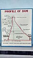
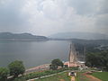
Krishna Raja Sagara, also popularly known as KRS, is a lake and the dam that creates it. They are close to the settlement of Krishna Raja Sagara in the Indian State of Karnataka. The gravity dam made of surki mortar is below the confluence of river Kaveri with its tributaries Hemavati and Lakshmana Tirtha, in the district of Mandya.

<span class="mw-page-title-main">Mettur</span> Town in Tamil Nadu, India

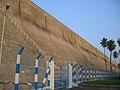
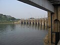
Mettur is an industrial and tourist town located in the Salem district in the state of Tamil Nadu, India. It is best known for the Mettur Dam which is the largest dam in south India.

<span class="mw-page-title-main">Palar River</span> River in southern India

Palar is a river of southern India. It rises in the Nandi Hills in Chikkaballapura district of Karnataka state, and flows 93 kilometres (58 mi) in Karnataka, 33 kilometres (21 mi) in Andhra Pradesh and 222 kilometres (138 mi) in Tamil Nadu before reaching its confluence into the Bay of Bengal at Vayalur about 75 kilometres (47 mi) south of Chennai. It flows as an underground river for a long distance only to emerge near Bethamangala town, from where, gathering water and speed, it flows eastward down the Deccan Plateau. The Towns of Bethamangala, Santhipuram, Kuppam,Mottur, Ramanaickenpet, Vaniyambadi, Ambur, Melpatti, Gudiyatham, Pallikonda, Anpoondi, Melmonavoor, Vellore, Katpadi, Melvisharam, Arcot, Ranipet, Walajapet, Kanchipuram, Walajabad, Chengalpattu, Kalpakkam, and Lattur are located on the banks of the Palar River. Of the seven tributaries, the chief tributary is the Cheyyar River.

<span class="mw-page-title-main">Stanley Reservoir</span> Reservoir in South India

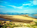
Stanley Reservoir located in Salem District of Tamil Nadu is one of largest fishing reservoirs in South India. It was completed in 1934 and was named after Lieutenant Colonel Sir George Frederick Stanley GCSI GCIE CMG, who served as the Governor of Madras from 1929 to 1934. Its main source of water is the River Kaveri (Cauvery). Three minor tributaries – Palar, Chennar and Thoppar – enter the Kaveri on its course above Stanley Reservoir. The water is retained by the Mettur Dam, Tamil Nadu.

<span class="mw-page-title-main">Kabini River</span> River in South India, tributary of Kaveri

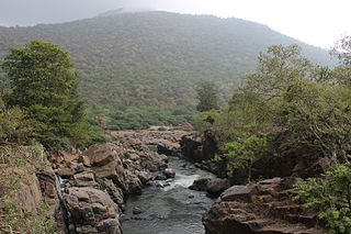
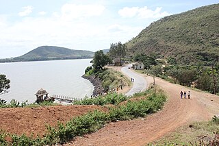
The Kabini River is one of the major tributaries of the river Cauvery in southern India. It originates near Kavilumpara in Kozhikode district of Kerala state by the confluence of the Panamaram River and the Mananthavady River. It flows eastward through Wayanad district, entering Mysore district of Karnataka, to join the Kaveri River in Mysore district of Karnataka

<span class="mw-page-title-main">Hogenakkal Falls</span> Waterfall on Karnataka-Tamil Nadu border

<span class="mw-page-title-main">Kaveri River water dispute</span> Water conflict in India

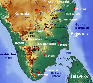
The sharing of waters of the Kaveri River has been the source of a serious conflict between the two Indian states of Tamil Nadu and Karnataka. The genesis of this conflict rests in two agreements in 1892 and 1924 between the Madras Presidency and Kingdom of Mysore. The 802 kilometres (498 mi) Kaveri river has 44,000 km2 basin area in Tamil Nadu and 32,000 km2 basin area in Karnataka. The inflow from Karnataka is 425 TMCft whereas that from Tamil Nadu is 252 TMCft.

<span class="mw-page-title-main">Sargur</span> Town in Karnataka, India

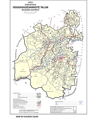
Sargur, is a small town located about 80 km from the town of Chamarajanagar And a Taluk of Mysore district of Karnataka, India. H D Kote (Heggadadevanakote) is about 12 km north of Sargur. It is 55 km from the city of Mysore. Bangalore International Airport is 200 km away. To be more elaborate, Sargur is 33.8 km from Nanjangud town (Karnataka), 35.1 km from Gundlupet town (Karnataka), 137.8 km from Udagamandalam town (Ooty) Valley and 38.8 km from Hunsur town (Karnataka).

<span class="mw-page-title-main">Hogenakkal Integrated Drinking Water Project</span> Fluorosis mitigation project in Tamil Nadu, India

Hogenakkal Integrated Drinking Water Project is a fluorosis mitigation drinking water project being undertaken at Hogenakkal, Dharmapuri district, state of Tamil Nadu, India. It is scheduled to be executed by Tamil Nadu Water Supply and Drainage Board (TWAD), with funding from Japan Bank for International Cooperation (JBIC) using Tamil Nadu's share of Cauvery river water. The project aims to supply safe drinking water to drought prone & fluorosis affected Dharmapuri and Krishnagiri districts of Tamil Nadu.

The Hogenakkal Water Dispute is a conflict between the Indian states of Tamil Nadu and Karnataka over the implementation of Hogenakkal Integrated Drinking Water Project, whose foundation stone was laid in February 2008. The Rs. 13.34 billion project envisages water supply to 4040,000 people in the fluorosis affected Dharmapuri and Krishnagiri districts of Tamil Nadu.

<span class="mw-page-title-main">Tmcft</span> Unit of volume abbreviation

Tmcft, (Tmc ft), (TMC), (tmc), is the abbreviation of thousand million cubic feet (1,000,000,000 = 109 = 1 billion), commonly used in India in reference to volume of water in a reservoir or river flow.

The Sarabanga River is a river flowing in the Salem district of the Indian state of Tamil Nadu. The origin of the river is traditionally placed at the Servarayan hills in Tamil Nadu. The river fulfills demands for agricultural irrigation in Danishpet village. The Sarabanga flows through the towns of Danishpet, Omalur, Thoppur, Tharamangalam, Dhadhapuram, Idappadi, Chettipatti, Peramachipalayam, and Thevur, and joins the Kaveri River near Annamar Kovil before flowing into the Bay of Bengal. Dams on the river are located at Peramachipalayam.

Upparu River is a river flowing in the Tirupur district of the Indian state of Tamil Nadu.

<span class="mw-page-title-main">Shanti Sagara</span> Lake in Karnataka, South India

Shanthi Sagara, also called Sulekere, is the second largest built lake in Asia. It is located at Sulekere of Channagiri taluka of Davanagere District in Karnataka state of India.

<span class="mw-page-title-main">Poondi reservoir</span> Reservoir in Tamil Nadu, India

Poondi Reservoir or Sathyamoorthy reservoir is the reservoir across Kotralai River in Tiruvallur district of Tamil Nadu State. It acts as the important water source for Chennai city which is 60 km away.

<span class="mw-page-title-main">2018 Tamil Nadu protests for Kaveri water sharing</span> Dispute on Cauvery river water sharing

The 2018 Kaveri River water sharing protests are a series of ongoing protests on the issue of water sharing problems from the River Kaveri between Tamil Nadu and Karnataka which are two states in India. The Kaveri water dispute has been a major controversial issue between Tamil Nadu and Karnataka over the years and the issue has been raised further with protests have been conducted across the state of Tamil Nadu by several groups including from the large pile of actors and directors who have temporarily stopped working on their projects, films over the Karnataka's sharing the Kaveri water to Tamil Nadu. The delay in establishing a Cauvery Management Board in order to share equal river share award has sparked off protests in Tamil Nadu against the Karnataka state government.

<span class="mw-page-title-main">Palar River (Kaveri basin)</span> River

Palar is a river in the Indian states of Karnataka and Tamil Nadu. It originates near Guthiyalathur in Bhavani Taluk of Erode district in Tamil Nadu and forms border between Karnataka and Tamil Nadu. Later, it flows into the Kaveri River near Palar in Karnataka and Tamil Nadu.

Jogulamba Barrage is a proposed barrage across Krishna River with full pond level (FPL) 274m. It would be located at Veltoor village, Peddamandadi mandal, Wanaparthy district, Telangana, India. This barrage is proposed to divert 3 TMC of water via lift to Yedula Reservoir being built as part of Palamuru-Rangareddy Lift Irrigation Scheme. This would also provide water for Dindi Lift Irrigation Project and Mahatma Gandhi Kalwakurthy Lift Irrigation Scheme.