Mahabaleshwar is a small town and a municipal council in Satara district, Maharashtra, India. It is a place of pilgrimage for Hindus because the Krishna river has its origin here. The British colonial rulers developed the town as a hill station, and served as the summer capital of Bombay Presidency during the British Raj.
Satara is a city located in the Satara District of Maharashtra state of India, near the confluence of the river Krishna and its tributary, the Venna. The city was established in the 16th century and was the seat of the Chhatrapati of Maratha Empire, Shahu I.

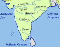
The Koyna River is a tributary of the Krishna River which originates in Mahableshwar, Satara district, western Maharashtra, India. It rises near Mahabaleshwar, a famous hill station in the Western Ghats. Unlike most of the other rivers in Maharashtra which flow East-West direction, the Koyna river flows in North-South direction. The Koyna River is famous for the Koyna Dam and the Koyna Hydroelectric Project. Koyna Hydroelectric Project is the 2nd largest completed hydroelectric project in India. The reservoir – Shivasagar Lake, is a huge lake of 50 km in length.

Panchgani, called Paachgani (in Marathi), is a hill station and municipal council in Satara district in Maharashtra, India. Panchgani attracts tourists throughout the year. It is also known for having many boarding schools.

The Bhima River is a major river in Western India and South India. It flows southeast for 861 kilometres (535 mi) through Maharashtra, Karnataka, and Telangana states, before joining the Krishna River. After the first sixty-five kilometers in a narrow valley through rugged terrain, the banks open up and form a fertile agricultural area which is densely populated.

Pratapgad is a mountain fort located in Satara district, in the Western Indian state of Maharashtra. The fort is situated 24 kilometres from the Mahabaleshwar hill station. The fort is now a popular tourist destination.
Wai is a town in Satara district of Maharashtra state in India. Located on the Krishna River, Wai was a prominent town during the Peshwa era. Two important Marathi Brahmin from ruling families had their origins here: Rani Lakshmibai of Jhansi and Gopikabai, wife of Nanasaheb Peshwa.

Satara district is a district of Maharashtra state in western India with an area of 10,480 km2 (4,050 sq mi) and a population of 3,003,741 of which 14.17% were urban. Satara is the capital of the district and other major towns include Medha, Wai, Karad, Malkapur, Koregaon, Rahimatpur, Dahiwadi, Koynanagar, Phaltan, Lonand, Mahabaleshwar, Panchgani, Vaduj and Mhaswad. This district comes under Pune Administrative Division along with Pune, Sangli, Solapur and Kolhapur. The district of Pune bounds it to the north, Raigad bounds it to the north-west, Solapur the east, Sangli to the south, and Ratnagiri to the west.

Maharashtra attracts tourists from other Indian states and foreign countries. It was the second most visited Indian state by foreigners and fifth most visited state by domestic tourists in the country in 2021. Aurangabad is the tourism capital of Maharashtra.
Khandala is a town and taluka in the Satara district in the Indian state of Maharashtra.
Kudal is a village in the Satara district, Maharashtra, India. It is surrounded by a river called Niranjana or Kudali. There is a big temple of 'Pimpleshwar & Wakadeshwar' at the river coast. Agriculture is the main land use in the village, with more than 75% of the total area being used for agricultural activities. The village has a close view to the historic Vairatgad Fort. It is central for 15 villages situated nearby Kudal Village.

Padali is a census village in the Satara district, in the Indian state of Maharashtra. It is surrounded by a Mountains on its three sides. There is a big temple of Heljaidevi Mandir at Village. Agriculture is the main occupation in the village with more than 75% of the total area being used for agricultural activities.
Kondhawali, also written Kondhavale or Kondhavali, is a village in the Satara District of Maharashtra, India.

Ninam is a census village in Satara district, in the Indian state of Maharashtra. It is a village surrounded by greenery and farms but also mountains. Agriculture is the main land use in the village with more than 75% of the total area being used for agricultural activities. The village close to historic Ajinkyatara fort, which is to the north. The large Jyotirlinga temple is in the center of the village.
Khambatki Ghat is a mountain pass on Pune-Kolhapur section of National Highway 48 in Maharashtra, India. This ghat lies in the Sahyadri mountain ranges and has picturesque mountain-scapes and a pleasant climate.
Garavadi (Ramnagar) is a census village in the Satara district, which is located in the India state of Maharashtra. There are a total of approximately 240 families residing within its borders. The village is located in the Khatav Tehsil of Satara district in Maharashtra, India. It is 32 km away from the sub-district headquarters of Vaduj, and 54 km away from the district headquarters of Satara. Research from 2009 shows that Garavadi village is also classified as a gram panchayat. According to the India Census in 2011, the village was recorded to have a population of 997, 478 of which were males, and the other 519 females.

Vele is a village in the Western region of Maharashtra state in India. It is located in Satara district of Maharashtra. Before it was a part of Bombay State and Princely state of Satara. It is located adjacent to Kanher Dam built on Venna River. There is a big temple of Bhairava at the village entrance. Also there are number of temples in closed vicinity of village. Surrounded by greenery and farms, agriculture is the main occupation in the village with more than 80% of the total area being used for agricultural activities. Though agriculture constitutes a mainstay of the economy of this village, besides a sizeable population working at various plum government positions does bolster the financial position.
Lonand is a city and municipal council in Satara district, Maharashtra. It is 227km from Mumbai, 81km from Pune, 47km from Wai & Satara,179km from Sangli and 30km from Phaltan.

Lalgun is a village in Khatav taluka of Satara district in the Indian state of Maharashtra. It is located on Pusegaon-Phaltan State Highway (SH-147) and comes under Koregaon Assembly constituency and Satara Lok Sabha constituency. Lalgun has a population of about 2930.

Wathar also known as Wathar Station is a town in Koregaon taluka of Satara district in the Indian state of Maharashtra. It is located on NH-965D and Pune-Miraj-Londa Railway Line. This town comes under Phaltan Assembly constituency and Madha Lok Sabha constituency. Wathar has a population of about 5393.