Bhakra Nangal Dam is a concrete gravity dam on the Satluj River in Bhakra Village near Bilaspur in Bilaspur district, Himachal Pradesh in northern India. The dam forms the Gobind Sagar reservoir.

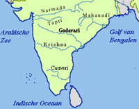
The Godavari River has its catchment area in seven states of India: Maharashtra, Telangana, Chhattisgarh, Madhya Pradesh, Andhra Pradesh, Karnataka and Odisha. The number of dams constructed in Godavari basin is the highest among all the river basins in India. Nearly 350 major and medium dams and barrages had been constructed in the river basin by the year 2012.

The Sriram Sagar Project is also known as the Pochampadu Project is an Indian flood-flow project on the Godavari. The Project is located in Nizamabad district, 3 km away from National Highway 44. It has been described by The Hindu as a "lifeline for a large part of Telangana".

Nagarjuna Sagar Dam is a masonry dam across the Krishna River at Nagarjuna Sagar which straddles the border between Palnadu district in Andhra Pradesh and Nalgonda district in Telangana. The dam provides irrigation water to the districts of Palnadu, Guntur, Nalgonda, Prakasam, Khammam, Krishna, and parts of West Godavari. It is also a source of electricity generation for the national grid.

The River Nagavali also known as Langulya is one of the main rivers of Southern Odisha and North Andhra States in India, between Rushikulya and Godavari basins.

Jayakwadi dam is an earthen dam located on Godavari river at the site of Jayakwadi village in Paithan taluka of Sambhajinagar district in Maharashtra, India. It is a multipurpose project. The water is mainly used to irrigate agricultural land in the drought-prone Marathwada region of the state. It also provides water for drinking and industrial usage to nearby towns and villages and to the municipalities and industrial areas of Sambhajinagar and Jalna districts. The surrounding area of the dam has a garden and a bird sanctuary.

The Polavaram Project is an under construction multi-purpose irrigation project on the Godavari River in the Eluru District and East Godavari District in Andhra Pradesh. The project has been accorded National project status by the Central Government of India. Its reservoir back water spreads up to the Dummugudem Anicut and approx 115 km on Sabari River side. Thus back water spreads into parts of Chhattisgarh and Odisha States. It gives major boost to tourism sector in Godavari Districts as the reservoir covers the famous Papikonda National Park, Polavaram hydro electric project (HEP) and National Waterway 4 are under construction on left side of the river. It is located 40 km to the upstream of Sir Arthur Cotton Barrage in Rajamahendravaram City and 25 km from Rajahmundry Airport.
The Pranahita Chevella Lift Irrigation Project is a lift irrigation project to harness the water of Pranahita tributary of Godavari river for use in the Telangana state of India. The river water diversion barrage across the Pranahita river is located at Thammidihatti village in Komaram Bheem district of Telangana. This lift canal is an inter river basin transfer link by feeding Godavari river water to Krishna river basin. The chief ministers of Telangana and Maharashtra states reached an agreement in 2016 to limit the full reservoir level (FRL) of the barrage at 148 m msl with 1.85 tmcft storage capacity. In the year 2016, this project is divided into two parts. The scheme with diversion canal from the Thammmidihatti barrage to connect to existing Yellampalli reservoir across the Godavari river is presently called Pranahita barrage lift irrigation project. This scheme is confined to providing irrigation facility to nearly 2,00,000 acres in Adilabad district using 44 tmcft water.
The Pulichintala Project is a multi-purpose water management project for irrigation, hydropower generation, and flood control in the state of Andhra Pradesh, India. It is a crucial irrigation facility for farmers in four coastal districts: West Godavari, Krishna, Guntur, Palanadu, and Prakasam, covering over 13 lakh acres. It has 24 gates and a balancing reservoir with a capacity of 46 Tmcft at 175 feet (53 m) MSL full reservoir level (FRL).
Sripada Yellampalli Project is an Irrigation project located at Yellampalli Village of Ramagundam rural Mandal, between Peddapalli district - Mancherial District of Telangana State, India. The project is fourth largest on the Godavari River in Telangana State. It is named after late legislator, D. Sripada Rao.
Rajiv Dummugudem Lift Irrigation Scheme is a lift irrigation scheme under execution which are located near Dummugudem, Khammam district in Telangana, India. There are three lift irrigation schemes by names Rajiv Dummugudem lift irrigation scheme, Indirasagar Rudrammakota Dummugudem lift irrigation scheme and Dummugudem to Sagar tail pond canal project. Rajiv Dummugudem lift irrigation scheme starting at 17°54′05″N80°52′45″E is planned to supply irrigation water for 200,000 acres in Khammam and Warangal districts drawing Godavari River water from the Dummugudem pond. Indira Dummugudem lift irrigation scheme starting at 17°33′49″N81°14′49″E is planned to supply irrigation water for 200,000 acres in Khammam, Krishna and West Godavari districts drawing Godavari River water from the back waters of Polavaram reservoir.
Lower Manair Dam also known as LMD was constructed across the Manair River, at Alugunur village, Thimmapur mandal, Karimnagar District, in the Indian state of Telangana during 1974 to 1985. It provides irrigation to a gross command area of 163,000 hectares.
The Upper Manair Dam is a dam on the Manair River, at Narmal Village, Gambhiraopet mandal, Rajanna Sircilla district, Telangana by Nizam.
The Kadem Project is a reservoir on the river Kadem, a tributary river of Godavari near Kademm Mandal, Nirmal District, Telangana. This project covers localised ayacut under Nirmal and Mancherial Districts.
Mid Manair Dam is a major irrigation project across the Manair River, at Manwada Village, Boinpalli Mandal, Rajanna Sircilla district, Telangana. It has a capacity of 25.87 tmcft with 25 radial gates. It has a capacity to irrigate 2,00,000 acres. It is part of the prestigious Kaleshwaram project from which 2-3 tmcft water will be lifted and router to Mid Manair Dam. The project was completed in April 2018.
SRSP Flood Flow Canal also known as Sriram Sagar Flood Flow Canal, is a 130 km long gravity canal from Sriram Sagar Project, Village & Mandal Mupkal, Nizamabad District to Mid Manair Dam, Manwada Village, Karimnagar District, Telangana.
Shanigaram Reservoir also known as Shanigaram Cheruvu is a medium irrigation project constructed across the Shanigaram River, at Shanigaram Village, Siddipet District, Telangana.
Taliperu Project also known as Taliperu Reservoir is a medium irrigation project constructed across the Taliperu River, a tributary of Godavari River, located at Cherla Village and Mandal, Bhadradri District, Telangana. This project utilizes about 5.0 TMC of water and creates 24,500 acres (9,900 ha) of Ayacut in both Cherla and Dummugudem Mandals, Bhadradri District.
The Kaleshwaram Lift Irrigation Project (KLIP) is a multi-purpose irrigation project on the Godavari River in Kaleshwaram, Bhupalpally, Telangana, India. Currently the world's largest multi-stage lift irrigation project, its farthest upstream influence is at the confluence of the Pranahita and Godavari rivers. The Pranahita River is itself a confluence of various smaller tributaries including the Wardha, Painganga, and Wainganga rivers which combine to form the seventh-largest drainage basin on the subcontinent, with an estimated annual discharge of more than 6,427,900 acre-feet (7,930 cubic hectometres) or 280 TMC. It remains untapped as its course is principally through dense forests and other ecologically sensitive zones such as wildlife sanctuaries.

The Wyra River is one of the tributaries of Munneru River, which is itself a major tributary of Krishna river. It originates at Wyra Reservoir near Wyra village, which was named after the reservoir.