Tungabhadra Dam

Last updated

Tungabhadra Dam
Tungabhadra Dam.jpg
India Karnataka relief map.svg
Red pog.svg
Location of Tungabhadra Dam in Karnataka
India relief location map.jpg
Red pog.svg
Tungabhadra Dam (India)
Official nameTungabhadra Dam
Location Hospet, Vijayanagara district, Karnataka, Munirabad, Koppal district, Karnataka,
India
Construction began1949
Opening date1953
Construction cost1,066,342 Dollars
Owner(s) Karnataka State
Operator(s)Tungabhadra Board
Dam and spillways
Type of dam Composite, Spillway length (701 m)
Impounds Tungabhadra River
Height49.50 m (162 ft) from the deepest foundation.
Length2,449 m (8,035 ft)
Spillway capacity650,000 cusecs
Reservoir
CreatesTungabhadra Reservoir
Total capacity3.73 cubic kms (132 tmcft)
Active capacity3.31 cubic kms (116.86 tmcft)
Inactive capacity2.3 tmcft (below 477.01 m msl)
Catchment area 28,180 km2 (10,880 sq mi)
Surface area350 km2 (140 sq mi)
Power Station
Operator(s)Karnataka Govt
Turbines Near toe of the dam and canal drops
Installed capacity 127MW
Website
www.tbboard.gov.in

The Tungabhadra Dam, also known as Pampa Sagar, is a water reservoir constructed across the Tungabhadra River in the city of Hosapete in Vijayanagara district, Karnataka, India. It is a multipurpose dam serving irrigation, electricity generation, flood control, etc. for the state. It is one of the only two non-cement dams in India, the other being the Mullaperiyar Dam in Kerala. The dam is built of surki mortar, a combination of mud and limestone, commonly used at the time of its construction.

Contents

The dam was a joint project undertaken in 1949 by the erstwhile Kingdom of Hyderabad and Madras Presidency when the construction began; [1] later, after India's constitution into a republic in 1950, it became a joint project between the governments of Mysore State (now Karnataka) and Hyderabad State (now Telangana). The construction was completed in 1953. The Tungabhadra Dam has withstood the test of time for over 70 years and is expected to well cross many more decades.

The chief architects who envisioned India's largest stone masonry dam were Vepa Krishnamurthy and Mr Pallimalli Papaiah. Shri Pallimalli Papaiah was chief engineer from Hyderabad state and Shri Tirumal Iyengar was chief engineer from Madras state. They envisioned it as being built with a large contingent of material and manual labour, as best suited to Indian labour availability and employment at that time. The chief contractor for the dam was Venkat Reddy Mulamalla from Konour, a village in Mahabubnagar, Telangana. The Canal on the Hyderabad side (now Telangana), The Northern canal takes off from the combined irrigation and power sluices. The first 19 miles of the canal is in a rugged terrain cutting through three ranges of hills and is held up by three reservoirs at miles 8, 14 and 16 respectively. The canal negotiates the last range of hills by means of a tunnel, named as PAPAIAH TUNNEL, and enters open country.

History

Tungabhadra dam with all of its gates open. Tungabhadra dam all gates open.jpg
Tungabhadra dam with all of its gates open.

The famine-ridden region of Rayalseema, then comprising the districts of Bellary, Anantapur, Kurnool and Cuddapah, attracted the attention of British engineers as early as 1860. To relieve the intensity of famines in these districts, proposals were made in 1860 to utilise the waters of the Tungabhadra through a storage reservoir and a system of canals to provide irrigation for the lands. Several agreements were reached for harvesting and imposing restrictions on utilising the Tungabhadra waters. Protracted negotiations and investigations lasted for about eighty years.

Proposals and plan agreements

In 1860, Sir Arthur Cotton of Madras Presidency originally conceived the Tungabhadra project. His proposals were further modified and developed subsequently, evolving it into a joint scheme with the Kingdom of Hyderabad. N. Paramseswaran Pillai accordingly revised the scheme in 1933. In 1940, Madras ordered a detailed investigation of the scheme. Based on the agreements made, an examination of a number of alternatives was conducted by L. Venkata Krishna Iyer, the then Superintending Engineer, Bellary, and F. M. Dowley, Chief Engineer, both from the kingdom, Between 1942-1947 further detailed investigations of the project were done by Mr. Pallimalli Papaiah (Chief Engineer- Hyderabad state) and M. S. Thirumal Iyengar (Chief Engineer) from the Madras presidency. The report thus submitted was accepted by the Government of Madras with certain modifications fixing the sill level at RL 1550 ft. The June 1944 agreement between Madras and Hyderabad enabled the two governments to finally begin the construction of the Tungabhadra project.

Foundation

The Tungabhadra Project was formally inaugurated by laying foundation stones on 28 February 1945 by Nawab Azam Jah, the Prince of Berar, on the left side of the dam and by the Baron Sir Arthur Hope, Governor of Madras, on the right. However, owing to India's freedom in 1947, the explosive political unrest in Hyderabad in 1948, and due to differences of opinion in certain technical matters, much headway could not be made until January 1949. Madras and Hyderabad engineers were sharply divided on:

  1. The nature of mortar to be used in the construction of the dam,
  2. The design of spillway,
  3. The design of overflow and non-overflow sections of the dam, and
  4. The contraction joints

These differences were referred to a board of engineers chaired by Sir M. Visveswaraya, the former prime minister of the Kingdom of Mysore and the chief architect of the Krishnaraja Sagar Dam in Mysore.

Construction

Excavation of the riverbed started in 1947 and masonry construction on 15 April 1949. With the help of a cofferdam constructed earlier, the foundation excavation was continued even during the floods season. The riverbed portion was tackled during the summer of 1950 (1949–50). Masonry in the riverbed blocks started in the 1951, followed by vigorous progress.

By 1952, the canals reached an advance and decisive stage of the construction. On 30 January 1952, the Government of Madras ordered (GO 382) an investigation of the high-level canal. On 15 November 1952, detailed estimates were prepared up to Mile 79/2 covering the reach just before Chinna-Hagari.

A major portion of the construction of the dam was over by the middle of 1953. The low-level canal excavation up to Mile 173 was completed by 1953. The water was led down into the canal on 1 July 1953 to derive partial benefits. Acquisition of lands and villages and rehabilitation of the displaced population from the water spread area of up to 1630 ft contour were completed by September 1953. About 90 villages and 54,452 people were affected. By October 1953, the structures were completed, substantially enabling the storage of water in the reservoir up to +1613.00 ft.

In 1954, an investigation of the remaining portion of canal from Mile 79/2 to Mile116/0 was completed and a project report was submitted to the Government of India for approval. The proposals were further reviewed and a final project report was submitted to the Planning Commission for clearance, estimating the costs at Rs. 21.90 crores.

Power canal works started in June 1954 and were completed by May 1957. The reservoir circle was entrusted with the construction of canal works in 1956. The balance portion of the low-level canal from Mile 173 to 203 that had to be excavated by the Government of Andhra Pradesh was completed by the end of March 1957. The balance of the works, namely the spillway, bridge road on the top of the dam, construction of utility tower, manufacture of crest grates for storing water up to 1633 level were completed in all respects by the end of June 1958. In 1958, water was let out up to and inclusive of Distributory 42 to serve an area of about 1.80 lakh acres. The cost of dam and appurtenant works was Rs. 16.96 crores.

A timeline of the construction of the dam
Foundation excavationCompleted by June 1952
MasonryCompleted by October 1953
Drilling and GroutingCompleted by August 1955
Crest Gates, embedded partCompleted by February 1955
Spillway shuttersCompleted by June 1955
Operation bridgesCompleted by February 1956
Counterweight erectionCompleted by January 195
HoistsCompleted by January 1957
Gate HouseCompleted by June 1957
Utility TowerCompleted by June 1958

Technical details

The dam forms the biggest reservoir across the Tungabhadra River with 101 tmcft of gross storage capacity at full reservoir level (FRL) 498 m MSL, and a water spread area of 378 square kilometres. [2] The dam is 49.39 meters high above its deepest foundation. [3] The left canals emanating from the reservoir supply water for irrigation to the entirety of Karnataka. The two right bank canals—one at low level and the other at high level—serve irrigation for Karnataka and the Rayalaseema region of Andhra Pradesh. Hydropower units are installed on canal drops. The reservoir water is used to supply water to downstream the barrages Rajolibanda and Sunkesula located on the Tungabhadra River. The identified water use from the project is 220 tmcft by the Krishna Water Disputes Tribunal. Karnataka and Andhra Pradesh got 151 tmcft and 79 tmcft water use entitlement respectively. [4]

Harness

Water commission

In 1954, the Central Water Commission advised the participating states to execute the water harness project in two stages. The first stage included an unlined canal with a head discharge of 2300 cusecs and the second stage a lined canal with 4000 cusecs head discharge.

The first stage scheme was inaugurated by Sir Chandulal Madhavlal Trivedi , Governor of Andhra Pradesh, on 2 October 1956 under the presidency of K. Manjappa, Chief Minister of Mysore. The first stage was almost completed by June 1966 at a cost of Rs. 920 lakhs: the canal was commissioned by releasing water for irrigation on 27 July 1966.

The second stage was approved in June 1967 for Rs. 385 lakhs. The works were completed by June 1970 at an estimated cost of Rs. 487 lakhs.

Powerplants

The Tungabhadra Hydroelectric Scheme was undertaken in the composite Madras State in the post-war period under the first five-year plan in the year 1950. The work on the project was taken up in 1951 but no appreciable progress was achieved till the end of 1953. The powerplant commission was then divided into two stages.

During 1957, two units of 9 MW each at the dam's powerhouse were installed and, in 1958, two units of 9MW each were installed at the powerhouse in Hampi. With this, the first stage of the scheme was completed in 1958. Power generation of this stage was commissioned during 1960–61. [5]

The second stage under this scheme was taken up in 1959. The plant erection started in the dam's powerhouse in November 1962 and in the powerhouse in Hampi in February 1963. Units 3 and 4 of both powerhouses started functioning by June 1964. The left side the powerhouses are designed to accommodate 4 units of 9MW each.

Sharing disputes

Disputes of sharing of waters of the Tungabhadra has its genesis in 1861 when the Kurnool-Cuddapah Canal (KC Canal) was proposed by the Government of Madras. Despite the agreement on the construction of the canal, there was no general agreement between the governments of Mysore and Madras on the sharing of Tungabhadra waters. In 1930, the Government of Madras proposed a joint project on the Tungabhadra. Subsequently, a number of conferences between the governments of Madras, Mysore, Hyderabad, and Bombay took place, but all were inconclusive. In 1936, there was an agreement between the governments of Madras and Mysore, followed by an agreement between Madras and Hyderabad in 1938. However, due to some differences in interpretation of the agreement between Madras and Hyderabad, no substantial progress was made in implementing the project. It was in a conference between the governments of Madras and Hyderabad held on 26 June 1944 that a final decision was arrived at on the allocation of waters as well as on taking up the project jointly and sharing the cost equally between the two states. [6]

Future potential for the dam

On the right side of the dam, the tall Sanduru hill ranges extending up to 800 m MSL are close to the periphery of the Tungabhadra reservoir. These hill ranges form the Sanduru valley located above 600 m MSL. This reservoir is an ideal place to install pumped storage hydropower plants and lift irrigation projects. A moderate high level storage reservoir of capacity 20 tmcft at FRL 620 m MSL, can be constructed by damming the Sanduru valley. This reservoir will serve as upper pond and existing Tungabhadra reservoir as tail pond for installing pumped-storage hydroelectricity units. The water pumped during the monsoon months into the upper pond can be diverted by gravity to irrigate an extensive area in the uplands up to 600 m MSL in Rayalaseema and Karnataka. This water can be pumped further to meet the drinking water requirements of Bengaluru city.[ citation needed ]

However, the available water resources at Tungabhadra dam are over-used, and water shortages are frequent. Water availability in the reservoir could be augmented by transferring water from the Krishna River, if a link canal were constructed from the Almatti reservoir to the Tungabhadra reservoir. [7] Envisaging small balancing reservoirs where this link canal is intercepting the tributaries of Tungabhadra River would facilitate water diversion to Tungabhadra reservoir for augmenting further water availability. Once the Almatti reservoir FRL is raised to 524 m MSL, this canals full supply level (FSL) can also be increased to 516 m MSL from 510 m MSL to reduce its construction cost and serve more area for irrigation in Karnataka. [8]

Flooding Tungabhadra dam Tunga Bhadhra Dam, HosaPete.jpg
Flooding Tungabhadra dam

Nearly 180 tmcft out of 230 tmcft water presently supplied from Tungabhadra reservoir to various canals can be replaced by reliable Krishna river water from the Narayanpur reservoir. [9] These are water supply to mid and lower reaches of Tungabhadra left bank canal, water assistance to Rajolibanda canal, water assistance to KC canal and mid and lower reaches of Tungabhadra right bank low level canal. This is achieved with a 20 km long tunnel from Narayanpur reservoir to the Maski nala reservoir / tank situated at 475 m MSL for drawing nearly 250 tmcft Krishna river water. [10] From this tank, north canal would supply Krishna river water by gravity flow to the lower reaches of Tungabhadra left bank canal in addition to bringing substantial uplands under irrigation in Karnataka and Telangana. From this tank, south canal would supply Krishna river water by gravity flow to the middle portion of Tungabhadra left bank canal in addition to bringing substantial uplands under irrigation in Karnataka and also connected to the Tungabhadra right bank low level canal at 425 m MSL near 15°22′09″N76°32′55″E / 15.36917°N 76.54861°E / 15.36917; 76.54861 (Tungabhadra RB LLC) through a 1.5 km long aqueduct over Tungabhadra main river. Water is also released from the Maski nala in to downstream Tungabhadra main river to meet continuous water needs of downstream Rajolibanda canal and KC canal. 180 tmcft water in addition to the water diverted from the Almatti reservoir to Tunghbadra reservoir can be utilised for uplands irrigation in Tungabhadra basin and Rayalaseema region of Andhra Pradesh. When these joint projects of Karnataka and Andhra Pradesh are constructed, nearly 400 tmcft water additionally will be available for irrigation and drinking purposes in the high drought risk uplands of Rayalaseema and Karnataka.[ citation needed ]

See also

Related Research Articles

<span class="mw-page-title-main">Krishna River</span> River in southern India

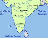
The Krishna River is a river in the Deccan plateau and is the third-longest river in India, after the Ganges and Godavari. It is also the fourth-largest in terms of water inflows and river basin area in India, after the Ganges, Indus and Godavari. The river, also called Krishnaveni, is 1,400 kilometres (870 mi) long and its length in Maharashtra is 282 kilometres. It is a major source of irrigation in the Indian states of Maharashtra, Karnataka, Telangana and Andhra Pradesh.

<span class="mw-page-title-main">Tungabhadra River</span> River in southern India

The Tungabhadra River is a river in India that starts and flows through the state of Karnataka during most of its course, Andhra Pradesh and ultimately joining the Krishna River near Murvakonda in Andhra Pradesh

<span class="mw-page-title-main">Sriram Sagar Project</span> Dam in Telangana, India

The Sriram Sagar Project is also known as the Pochampadu Project is an Indian flood-flow project on the Godavari. The Project is located in Nizamabad district, 3 km away from National Highway 44. It has been described by The Hindu as a "lifeline for a large part of Telangana".

<span class="mw-page-title-main">Nagarjuna Sagar Dam</span> Dam in Andhra Pradesh & Nalgonda district, Telangana

Nagarjuna Sagar Dam is a masonry dam across the Krishna River at Nagarjuna Sagar which straddles the border between Palnadu district in Andhra Pradesh and Nalgonda district in Telangana. The dam provides irrigation water to the districts of Palnadu, Guntur, Nalgonda, Prakasam, Khammam, Krishna, and parts of West Godavari. It is also a source of electricity generation for the national grid.

The Upper Krishna Project (UKP) is an irrigation project across the Krishna River to provide irrigation to the drought-prone areas of Vijayapura district, Karnataka, Bagalkot, Kalburgi, Yadgir and Raichur districts in the state of Karnataka in south India. The project had been designed by the Government of Karnataka to irrigate 1,536,000 acres of land (6,220 km2).

<span class="mw-page-title-main">Krishna Water Disputes Tribunal</span> Indian tribunal

Government of India constituted a common tribunal on 10 April 1969 to adjudicate the river water utilization disputes among the river basin states of Krishna and Godavari rivers under the provisions of Interstate River Water Disputes Act – 1956. The common tribunal was headed by Sri RS Bachawat as its chairman with Sri DM Bhandari and Sri DM Sen as its members. Krishna river basin states Maharashtra, Karnataka and old Andhra Pradesh insisted on the quicker verdict as it had become more expedient for the construction of irrigation projects in Krishna basin. So the proceedings of Krishna Water Disputes Tribunal (KWDT) were taken up first separately and its final verdict was submitted to GoI on 27 May 1976.

<span class="mw-page-title-main">Srisailam Dam</span> Dam in Andhra Pradesh and Telangana, India

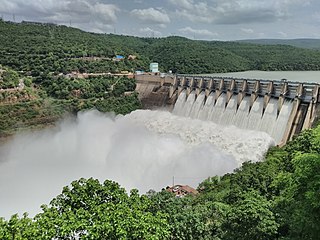
The Srisailam Dam is constructed across the Krishna River in Nandyal district, Andhra Pradesh and Nagarkurnool district, Telangana near Srisailam temple town and is the 2nd largest capacity working hydroelectric station in India.

<span class="mw-page-title-main">Almatti Dam</span> Dam in North Karnataka, India

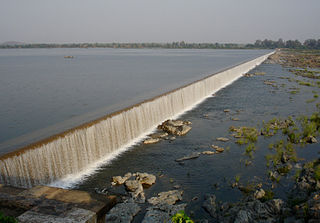
The Lal Bahadur Shastri Dam is also known as Almatti Dam is a hydroelectric project on the Krishna River in North Karnataka, India which was completed in July 2005. The target annual electric output of the dam is 560 MU.

<span class="mw-page-title-main">Polavaram Project</span> Dam in Eluru district, Andhra Pradesh

The Polavaram Project is an under construction multi-purpose irrigation project on the Godavari River in the Eluru District and East Godavari District in Andhra Pradesh. The project has been accorded National project status by the Central Government of India. Its reservoir back water spreads up to the Dummugudem Anicut and approx 115 km on Sabari River side. Thus back water spreads into parts of Chhattisgarh and Odisha States. It gives major boost to tourism sector in Godavari Districts as the reservoir covers the famous Papikonda National Park, Polavaram hydro electric project (HEP) and National Waterway 4 are under construction on left side of the river. It is located 40 km to the upstream of Sir Arthur Cotton Barrage in Rajamahendravaram City and 25 km from Rajahmundry Airport.

The Pranahita Chevella Lift Irrigation Project is a lift irrigation project to harness the water of Pranahita tributary of Godavari river for use in the Telangana state of India. The river water diversion barrage across the Pranahita river is located at Thammidihatti village in Komaram Bheem district of Telangana. This lift canal is an inter river basin transfer link by feeding Godavari river water to Krishna river basin. The chief ministers of Telangana and Maharashtra states reached an agreement in 2016 to limit the full reservoir level (FRL) of the barrage at 148 m msl with 1.85 tmcft storage capacity. In the year 2016, this project is divided into two parts. The scheme with diversion canal from the Thammmidihatti barrage to connect to existing Yellampalli reservoir across the Godavari river is presently called Pranahita barrage lift irrigation project. This scheme is confined to providing irrigation facility to nearly 2,00,000 acres in Adilabad district using 44 tmcft water.

The Pulichintala Project is a multi-purpose water management project for irrigation, hydropower generation, and flood control in the state of Andhra Pradesh, India. It is a crucial irrigation facility for farmers in four coastal districts: West Godavari, Krishna, Guntur, Palanadu, and Prakasam, covering over 13 lakh acres. It has 24 gates and a balancing reservoir with a capacity of 46 Tmcft at 175 feet (53 m) MSL full reservoir level (FRL).

<span class="mw-page-title-main">Rajiv Dummugudem Lift Irrigation Scheme</span>

Rajiv Dummugudem Lift Irrigation Scheme is a lift irrigation scheme under execution which are located near Dummugudem, Khammam district in Telangana, India. There are three lift irrigation schemes by names Rajiv Dummugudem lift irrigation scheme, Indirasagar Rudrammakota Dummugudem lift irrigation scheme and Dummugudem to Sagar tail pond canal project. Rajiv Dummugudem lift irrigation scheme starting at 17°54′05″N80°52′45″E is planned to supply irrigation water for 200,000 acres in Khammam and Warangal districts drawing Godavari River water from the Dummugudem pond. Indira Dummugudem lift irrigation scheme starting at 17°33′49″N81°14′49″E is planned to supply irrigation water for 200,000 acres in Khammam, Krishna and West Godavari districts drawing Godavari River water from the back waters of Polavaram reservoir.

"Rajaolibanda Diversion Scheme" or "RDS" is an irrigation project located across River Tungabhadra in Jogulamba Gadwal district of Telangana, Kurnool district of Andhra pradesh and Raichur district of Karnataka. It is an inter-state barrage on the Tungabhadra river to supply water to Karnataka, Telangana and Andhra Pradesh states. The full reservoir level of this project is 332.32 m MSL.

Handri-Neeva Sujala Sravanthi project is the longest water canal project in the region of Rayalaseema, Andhra Pradesh, India. The project was conceived to provide a reliable irrigation and drinking water supply for the region through drawing flood waters from the Srisailam reservoir.

<span class="mw-page-title-main">K. C. Canal</span>

Kurnool Cuddappah Canal popularly known as K.C. Canal is an irrigation canal located in Kurnool and Kadapa districts in Andhra Pradesh, India.

Jeedipalli Reservoir is an irrigation project located in Anantapur district in Andhra Pradesh, India. It receives water from Handri-Neeva canal which draws water from Srisailam reservoir. It is located in Jeedipalli village of Beluguppa mandal.

<span class="mw-page-title-main">Basava Sagara</span> Dam in Karnataka, India

Basava Sagar Dam, previously known as Narayanpura Dam, is a dam constructed across the Krishna River at Yadgir District, Karnataka State, India. The reservoir that it impounds is known as Basava Sagar, and has a total storage capacity of 37.965 tmcft (1.075 km³), with 30.5 tmcft (0.85 km³) live storage. The full reservoir level is 492.25 m MSL and the minimum draw down level is 481.6 m MSL. It was a single purpose project meant only for irrigation, but downstream electrical generation and drinking water considerations enter into its management. The dam is 29 meters high and over 10.637 kilometres (6.610 mi) long, and has 30 gates for water release. 22 Spillway Gates are present in the Dam It took Rs. 50.48 crore to complete.

<span class="mw-page-title-main">Nagarjuna Sagar tail pond</span> Reservoir in India

Nagarjuna Sagar tail pond is a multipurpose reservoir located 21 km downstream from the Nagarjuna Sagar Dam across the Krishna River near Satrasala in Nalgonda district, India. Its gross water storage capacity is 6 Tmcft. The reservoir water spread area extends up to the toe of the Nagarjuna Sagar dam. The project was completed by July 2014.

Pattiseema Lift Irrigation Project is a river interlinking project which connects Godavari River to Krishna River. This project has thereby become the first of such irrigation type projects in the country to be completed in time without any budget enhancements. It also holds a record in Limca Book of Records. The project was Inaugurated by the Chief Minister of Andhra Pradesh Nara Chandrababu Naidu in March 2016 while the project was completed in one year record of time.

Jogulamba Barrage is a proposed barrage across Krishna River with full pond level (FPL) 274m. It would be located at Veltoor village, Peddamandadi mandal, Wanaparthy district, Telangana, India. This barrage is proposed to divert 3 TMC of water via lift to Yedula Reservoir being built as part of Palamuru-Rangareddy Lift Irrigation Scheme. This would also provide water for Dindi Lift Irrigation Project and Mahatma Gandhi Kalwakurthy Lift Irrigation Scheme.

References

  1. "The Secret History of Hyderabad State of the Nizam (South India; 1724 – 1948)". 28 June 2016.
  2. "Salient data of Tungabhadra dam" . Retrieved 23 July 2013.
  3. "Tungabhadra Dam D05483". Archived from the original on 6 January 2014. Retrieved 23 July 2016.
  4. "Page 97, Further report of KWDT 1, Volume IV". 1976. Retrieved 17 August 2016.
  5. "History of Tungabhadra Project | TUNGABHADRA BOARD". tbboard.gov.in. Retrieved 18 August 2018.
  6. "Agreements for Harnessing Tungabhadra Water | TUNGABHADRA BOARD". tbboard.gov.in. Retrieved 18 August 2018.
  7. NWDA. "Feasibility Report of Krishna (Almatti) Pennar Link" . Retrieved 15 January 2015.
  8. NWDA. "Section 6.5.4 of Chapter 6, Feasibility Report of Krishna (Almatti) Pennar Link" (PDF). Retrieved 15 August 2016.
  9. "Narayanapura Dam D04315". Archived from the original on 23 March 2018. Retrieved 15 August 2015.
  10. "Maskinala D05465" . Retrieved 15 August 2015.[ permanent dead link ]

15°18′N76°20′E / 15.300°N 76.333°E / 15.300; 76.333