Wayanad, is an Indian district in the north-east of Kerala state with administrative headquarters at the municipality of Kalpetta. It is the only plateau in Kerala. The Wayanad Plateau forms a continuation of the Mysore Plateau, the southern portion of Deccan Plateau. It is set high in the Western Ghats with altitudes ranging from 700 to 2100 meters. Vellari Mala, a 2,240 m (7,349 ft) high peak situated on the trijunction of Wayanad, Malappuram, and Kozhikode districts, is the highest point in Wayanad district. The district was formed on 1 November 1980 as the 12th district in Kerala, by carving out areas from Kozhikode and Kannur districts. An area of 885.92 km2 of the district is forested. Wayanad has three municipal towns—Kalpetta, Mananthavady and Sulthan Bathery. There are many indigenous tribes in this area. The Kabini River, a tributary of Kaveri River, originates at Wayanad. Wayanad district, along with the Chaliyar valley in neighbouring Nilambur in Malappuram district, is known for natural gold fields, which are also seen in other parts of the Nilgiri Biosphere Reserve. Chaliyar river, which is the fourth longest river of Kerala, originates on the Wayanad plateau. The historically important Edakkal Caves are located in Wayanad district.

Mananthavady is a municipality and taluk in the Wayanad district of Kerala, India.
Kurichiya or Kurichiyar also known as Hill Brahmins or Malai Brahmins are a matrilineal tribe of Kerala distributed mainly in Wayanad and Kannur districts of Kerala, India. Kurichiyans are one of the Scheduled Tribes of Kerala practicing agriculture.

Brahmagiri, is a mountain range in the Western Ghats of south India. It is situated on the border between Kodagu district in Karnataka state in the north and Wayanad district of Kerala state on the south. Brahmagiri Hill, at 1608 m height, is a scenic tourist attraction. The top of Brahmagiri Hill is well forested and has much wildlife.

Kalpetta is the largest town and municipality in the Wayanad district, state of Kerala, India. Kalpetta is the headquarters of Wayanad district as well as the headquarters of Vythiri taluk. It is a bustling town surrounded by dense coffee and tea plantations and mountains. It lies on the Kozhikode-Mysore National Highway NH 766 at an altitude of about 780 m above sea level. Kalpetta is 72 km from Kozhikode and 140 km from Mysore.

Sultan Bathery, formerly known as Ganapathyvattam is a town and municipality in Wayanad district of Kerala, India, near the borders with Tamil Nadu and Karnataka states. It is The largest town in Wayanad district, it is the headquarters of Sultan Bathery taluk.

The Kabini River is one of the major tributaries of the river Cauvery in southern India. It originates near Kavilumpara in Kozhikode district of Kerala state by the confluence of the Panamaram River and the Mananthavady River. It flows eastward through Wayanad district, entering Mysore district of Karnataka, to join the Kaveri River in Mysore district of Karnataka

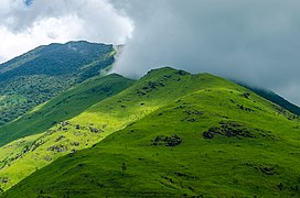
Chembra Peak is a mountain in the state of Kerala, India, with an elevation of 2,100 m (6,890 ft) above sea level. The highest peak in the Wayanad hills and one of the highest peaks in the Western Ghats, adjoining the Nilgiri Hills and Vellarimala, it is located in the Wayanad district of Kerala, near the town of Meppadi and 8 km (5 mi) south of Kalpetta.

Peravoor is a small town in Kannur district of Kerala state in India. It is east of Kannur (54 km) and Thalassery (44 km). And Iritty, the nearest municipality, is 15 km to the north of Peravoor. Peravoor is situated in the Western Ghats mountain range.

Pulpally is a mid-sized town in Wayanad District of Kerala, India.Pulpally also known as 'The land of black gold'. Pulpally is also famous for its pure wild Wayanad honey. The only Seetha devi temple in Kerala is situated on Pulpally. Geographically a small town in Sultan Bathery Taluk and a "Grama Panchayath" under the local self governance system. It is about 24 km from Sultan Bathery, and is almost surrounded by forest. The main source of income is agriculture.

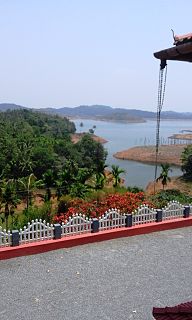
Banasura Sagar Dam, which impounds the Karamanathodu tributary of the Kabini River, is part of the Indian Banasurasagar Project consisting of a dam and a canal project started in 1979. The goal of the project is to support the Kakkayam Hydro electric power project and satisfy the demand for irrigation and drinking water in a region known to have water shortages in seasonal dry periods. The dam is also known as Kuttiyadi Augmentation Main Earthen Dam. The dam has a height of 38.5 metres (126 ft) and length of 685 metres (2,247 ft).

Chempanoda/Chempanod is a village towards the north east of Kozhikode district of Kerala in India. This place lies adjacent to the tourist spot Peruvannamuzhi.
Padinharathara is a village and important junction in Wayanad district in the state of Kerala, India. The biggest earth dam in Asia is situated in this Village.
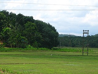
Payyampally is a village in Wayanad district in the state of Kerala, India.

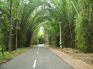
Kallody is a village in the Edavaka Grama panchayath of the Wayanad district, Kerala, India. This village falls under the Mananthavady Taluk. The Hill Highway (Kerala) SH-59 passes through this village town.
Kuttiady is one of the villages situated in the north-eastern part of Kozhikode district in the North Malabar of Kerala, India. It is located 24 km (15 mi) from Vadakara and 50 km (31 mi) from Kozhikode. Kuttiady is situated in the slopes of the Western Ghats. The four-sided junction of Kuttiady helps the travellers to reach different destinations, The east of Kuttiady is Wayanad district and the state highway to the north from the junction of Kuttiady allows travellers to enter Kannur International Airport and Thalassery. The state highway to the south from the junction of Kuttiady helps travellers to reach Calicut. The one and only hydro-electric station of Malabar is situated in Kuttiady River, which is flowing through the heart of Kuttiady semi-urban city.

Banasura Hill Resort is a nature resort in Wayanad District of North Kerala, India; located 37 kilometres (23 mi) away from Kalpetta, the district headquarters. It stands at an altitude of 3,200 feet (980 m) above sea level on a 35 acres (14 ha) plot amidst the mountains of the Western Ghats declared as one of the traditionally preserved sites in the world by UNESCO.

The district capital of Wayanad is Kalpetta town. Kalpetta has very good road connectivity with the rest of Kerala and neighboring South Indian cities. National Highway 766 (India) NH766 connects Kalpetta with Kozhikode and Mysore. State Highways connect Kalpetta with Ooty in Tamil Nadu and Madikeri in Karnataka.
The Wayanad District of Kerala, India has a wide variety of tourist attractions ranging from religious sites to natural, and historical sites. This district is divided into three towns, Kalpetta, Sultan Bathery and Mananthavady. All Major Tourism destinations in the district are maintained by the District Tourism Promotion Council.