Kollam, also known by its former name Quilonpronunciation (help·info)(sometimes referred to by its historical name Desinganadu), is an ancient seaport and city on the Malabar Coast of India bordering the Laccadive Sea, which is a part of the Arabian Sea. It is 71 km (44 mi) north of the state capital Thiruvananthapuram. The city is on the banks of Ashtamudi Lake and the Kallada river. It is the headquarters of the Kollam district. Kollam is the fourth largest city in Kerala and is known for cashew processing and coir manufacturing. It is the southern gateway to the Backwaters of Kerala and is a prominent tourist destination.
Fort Kochi, Fort Cochin in English, Cochim de Baixo in Cochin Portuguese creole, is a neighbourhood of Cochin (Kochi) city in Kerala, India. Fort Kochi takes its name from the Fort Manuel of Cochin, the first European fort on Indian soil, controlled by the Portuguese East Indies. This is part of a handful of water-bound islands and islets toward the south-west of the mainland Kochi, and collectively known as Old Cochin or West Cochin. Adjacent to this is the locality of Mattancherry. In 1967, these three municipalities along with a few adjoining areas, were amalgamated to form the Kochi Municipal Corporation.

Malabar District, also known as Malayalam District, was an administrative district on the southwestern Malabar Coast of Bombay Presidency (1792-1800) and Madras Presidency (1800-1947) in British India, and independent India's Madras State (1947-1956). It was the most populous and the third-largest district in the erstwhile Madras State. The British district included the present-day districts of Kannur, Kozhikode, Wayanad, Malappuram, Palakkad, Chavakad Taluk and parts of Kodungallur Taluk of Thrissur district, and Fort Kochi area of Ernakulam district in the northern and central parts of present Kerala state, the Lakshadweep Islands, and a major portion of the Nilgiris district in Tamil Nadu. The detached settlements of Tangasseri and Anchuthengu, which were British colonies within the kingdom of Travancore in southern Kerala, also formed part of Malabar District until 1927. Malayalam was the administrative as well as the most spoken lingua franca of Malabar District during British Rule. Jeseri, a distinct dialect of Malayalam, was spoken in the Laccadive Islands. Malabar District merged with the erstwhile state of Travancore-Cochin (1950-1956) to form Kerala according to the States Reorganisation Act, 1956. On the same day, the present Kasaragod district of South Canara District was also attached to Malabar, and the Laccadive & Minicoy Islands of Malabar were reorganised to form a new Union Territory. Malabar was trifurcated to form the districts of Kannur, Kozhikode, and Palakkad, on 1 January 1957.
The term Kerala was first epigraphically recorded as Cheras (Keralaputra) in a 3rd-century BCE rock inscription by the Mauryan emperor Ashoka of Magadha. It was mentioned as one of four independent kingdoms in southern India during Ashoka's time, the others being the Cholas, Pandyas and Satyaputras. The Cheras transformed Kerala into an international trade centre by establishing trade relations across the Arabian Sea with all major Mediterranean and Red Sea ports as well those of Eastern Africa and the Far East. The dominion of Cheras was located in one of the key routes of the ancient Indian Ocean trade. The early Cheras collapsed after repeated attacks from the neighboring Cholas and Rashtrakutas.

Mount Carmel Convent Anglo-Indian Girls High School is an English-medium all-through school in Tangasseri, Kollam District in Kerala, India. Located on the shores of the Arabian Sea, it consists of a day school, and a boarding house located within the convent. The school was founded on 22 July 1885 by Mother Veronica of the Passion. It was one of the first English-medium schools in the Kollam District, and is one of its two originally Anglo-Indian schools. The school awards qualifications based on the ICSE/ISC syllabus.
Hinduism, Islam and Christianity are the prominent religions in Kollam district. As per the Census 2011, out of the total population of 2,635,375 persons, 64.42% follow Hinduism, 19.30% follow Islam and 16.00% follow Christianity. Other religions comprise 0.04%, while 0.25% did not state any religion.

Kollam Beach, also known as Mahatma Gandhi Beach, is a beach at Kollam city in the Indian state of Kerala. Kollam Beach is the first 'Beach Wedding Destination' in Kerala.

Fort Thomas or St. Thomas Fort or Fortaleza da São Tomé, also known as Tangasseri Fort, is a ruined fort located in the beach town of Tangasseri on the shores of the Arabian Sea in the city of Kollam, Kerala, India. It is located around 5 kilometres (3.1 mi) from the city center of Kollam and 71 kilometres (44 mi) from the state capital Thiruvananthapuram.

Kollam Port is one of the historic ports situated 4 kilometres (2.5 mi) away from Downtown Kollam ,14 km north of Paravur and 24 km north of Varkala Town It is the second largest port in Kerala by volume of cargo handled and facilities. Located on the south-west coast of India, under the name of Quilon Port it became one of the country's most important trade hubs from the ninth to the seventeenth centuries. Kollam was one of the five Indian ports visited by Ibn Battuta.

Kovilthottam Lighthouse is situated at Kovilthottam in Kollam district of Kerala. The 18-meter tall lighthouse tower is painted with black and white alternating bands. The lighthouse has been provided to serve the Port of Neendakara situated at the entrance to Ashtamudi Backwaters.

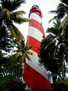
Tangasseri Lighthouse or Thangassery Lighthouse is situated at Tangasseri in Kollam city of the Indian state of Kerala. It is one of the two lighthouses in the Kollam Metropolitan Area and is maintained by the Cochin Directorate General of Lighthouses and Lightships. In operation since 1902, the cylindrical lighthouse tower painted with white and red oblique bands has a height of 41 metres (135 ft), making it the second tallest lighthouse in Kerala coast. Tangasseri Lighthouse is one of the most visited lighthouses in Kerala.
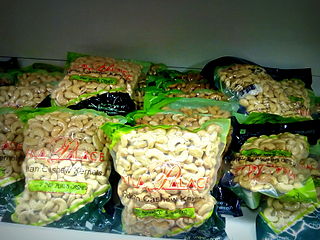
The Cashew business in Kollam is based in the eponymous city, which is known as the Cashew Capital of the World. Kollam is the largest processed cashew exporter in the world. As of 2011 there were more than 600 cashew processing units in the city. About 800,000 tonnes of raw cashews are imported to the city for processing every year. 80% of India's export quality cashew kernels were prepared in Kollam. Kollam has remained the cashew capital of the world since 1930s.
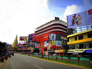
Kollam or Quilon is an old seaport and a city on the Laccadive Sea coast in Kerala, India, on Ashtamudi Lake. The city remains notable as the ancient commercial capital of Kerala and the southwestern Indian coast, in addition to its fame as the "Cashew Capital of the World". The Kollam Municipal Corporation has the second largest budget in Kerala in terms of revenue and expenditure.

The Infant Jesus Cathedral is a historic Roman Catholic church established by Portuguese during 1614, situated at Tangasseri in the city of Quilon (Kollam), India. It is now the cathedral i.e the Seat of the Bishop of Roman Catholic Diocese of Quilon, the ancient and first catholic diocese of India. The Church remains as a memento of the Portuguese rule of old Quilon city.

Kollam KSWTD Boat Jetty or Kollam KSWTD Ferry Station is an transport hub in the city of Kollam in Kerala, India, one of 14 ferry stations owned by the Kerala State Water Transport Department.
The Portuguese Cemetery of Tangasseri in Kollam city, India, was constructed around 1519 as part of the Portuguese invasion of the city. Buckingham Canal, a small canal between Tangasseri Lighthouse and the cemetery, is situated very close to the Portuguese Cemetery. A group of pirates known as the Pirates of Tangasseri formerly lived at the Cemetery. The remnants of St. Thomas Fort and Portuguese Cemetery still exist at Tangasseri.
Buckingham Canal in Kollam is a 450-year-old Portuguese built heritage landmark at Tangasseri. It is one of the rare existing ancient remnants in city of Kollam (Quilon) - Commercial Capital of ancient Malabar coast. The Canal is believed to be a key conduit built by the Portuguese some 450 years ago inside their strategic territory, the Fort Thomas. Quilon along with Tangasseri was one among the ancient Portuguese settlements in Asia.

Quilon or Coulãopronunciation (help·info), officially Kollampronunciation (help·info) is one of the ancient civilizations in India.It is one of the oldest port cities in the Malabar Coast and was the capital city of historic Venad Kingdom and Travancore Kingdom. Quilon was once an important trading port in India. It was also known as Desinganadu. It is now known as the "Cashew Capital of the World".

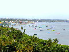
City of Kollam or Quilon is a Port city in South India and was the commercial capital of erstwhile Kingdom of Travancore. It is situated on the Laccadive Sea coast of South Kerala. The city is known as the "Gateway to the backwaters of Kerala". The city lies on the banks of Ashtamudi Lake, Kerala's second largest lake, on the Arabian sea coast. Major parts of Kollam city are covered by Ashtamudi Lake.