Marayur

Last updated

Marayur
Marayoor
Town
Kovilkadavu.jpg
Marayoor
India Kerala location map.svg
Red pog.svg
Marayur
Location in Kerala, India
India location map.svg
Red pog.svg
Marayur
Marayur (India)
Coordinates: 10°16′34″N77°09′41″E / 10.2762°N 77.1615°E / 10.2762; 77.1615
CountryFlag of India.svg  India
State Kerala
District Idukki
Government
  TypeGrama Panchayat
Area
  Total224.99 km2 (86.87 sq mi)
Population
 (2011)
  Total12,399
  Density55/km2 (140/sq mi)
Languages
  Official Malayalam, English [1]
  Regional Tamil, [2] Malayalam
Time zone UTC+5:30 (IST)
PIN
685620
Telephone code 04865
Vehicle registration KL-68

Marayur or Marayoor is a town in Devikulam taluk of Idukki district in the southwestern India n state of Kerala. It is located 42 kilometers north of Munnar on SH 17 connecting Munnar with Udumalpet, Tamil Nadu. Marayur is situated at around 990 metres above mean sea level and is the only place in Kerala that has natural sandalwood forests. Ancient dolmens and rock paintings in Marayur date back to the Stone Age. In 1991 Marayur had a population of 9,590. [3]

Contents

Demographics

As per 2011 census report, Marayoor grama panchayat had population of 12,399 of which 6,192 are males and 6,207 are females. Total number of households in panchayat is 3,307. Marayoor is the only village in Marayoor panchayat. [4]

History

Marayur claims to be a part of a Stone Age civilization that is as old as 10,000 B.C. [5] [6] It is also home to a later period of large-scale dolmen-building. [7] People migrated from Tamil Nadu to this area when the Madurai king Bangaru Thirumala Nayak was defeated by Chanda Saheb, in the eighteenth century CE. The migrants created five villages, being Kanthalloor, Keezhanthur, Karayur, Marayur and Kottakudi. These villages were called the "Anju nadu", literally meaning "five lands".[ citation needed ]

Megalithic Dolmens

Dolmens of Marayur Muniyara.jpg
Dolmens of Marayur

Also called Muniyaras, these dolmens belong to the Iron Age. These dolmenoids were burial chambers made of four stones placed on edge and covered by a fifth stone called the cap stone. Some of these Dolmenoids contain several burial chambers, while others have a quadrangle scooped out in laterite and lined on the sides with granite slabs. These are also covered with cap stones. Dozens of Dolmens around the area of old Siva temple (Thenkasinathan Temple) at Kovilkadavu on the banks of the River Pambar and also around the area called Pius nagar, and rock paintings on the south-western slope of the plateau overlooking the river have attracted visitors.[ citation needed ]

Apart from the dolmens of Stone Age, several dolmens of Iron Age exist in this region especially on the left side of river Pambar as is evident from the usage of neatly dressed granite slabs for the dolmens. At least one of them has a perfectly circular hole of 28 cm diameter inside the underground chamber. This region has several types of dolmens. Large number of them are overground with about 70–90 cm height. Another type has a height 140–170 cm. There is an overground dolmen with double length up to 350 cm. Fragments of burial urns are also available in the region near the dolmens. This indicates that the dolmens with 70–90 cm height were used for burial of the remains of people of high social status. Burial urns were used for the burial of the remains of commoners. The dolmens with raised roofs might have been used for habitation of people. Why some people lived in the cemeteries has not been satisfactorily explained.[ citation needed ]

Rock paintings

A rock painting at Marayoor Marayoor Rock paintings 01.JPG
A rock painting at Marayoor

Ancient rock paintings are part of Marayur heritage at Attala, Ezhuthu Guha (literally means "cave of writing"), Kovilkadavu and Manala in Marayur panchayat. Attala is situated in the west part of Marayur Township and more than 90 painted motifs can be seen here. The rock paintings of Attala are situated in a colossal east facing rock shelter 1500 meters above mean sea level. Most of the paintings at Attala are abstract designs except for a few human and animal figures.[ citation needed ]

Ezhuthu Guha rock paintings are sited in the Koodakavu Sandalwood Reserve Forest at Marayur in the Marayur Panchayat at an elevation of 1000 meters above mean sea level. More or less 90 painted motifs can be seen here. However, as the place is the most famous rock art site in Kerala, it attracts a large number of visitors and has been extensively vandalized since it was brought to wide public attention.[ citation needed ]

Kovilkadavu is less than five kilometers from Marayur town and the place is famous for Neolithic dolmens and rock paintings. Ten 10 painted motifs are located on the south-western slope of the plateau overlooking the Pambar river. There is a rock painting at Manala in Chinnar Wildlife Sanctuary of Marayur near the Alampetty tribal settlement. Here, a picture of a deer and a man can be seen. In close proximity to this art site, a new rock painting has been newly discovered.[ citation needed ]

Topography and Climate

Karimutty waterfalls near Marayoor Karimutty falls-marayoor.jpg
Karimutty waterfalls near Marayoor

The terrain is highly undulating with altitudes ranging from 500 m at Chinnar to over 2300 m at Nandala malai, and the same varying topography of Marayur can be observed in Marayur with mountains, rain forests, deciduous forests, riparian forests, scrub forests, brooks, Paddy Fields, river, waterfalls, rocky hills, sholas and hamlets. Natural vegetation includes tropical evergreen forests and grasslands. Soil type is forest loam with a high organic matter content. The climate in Marayur is characterized by mild wet winters and hot dry summers. Temperature in winter (November to January) may go down to 20 degrees Celsius and in summer it may go up to 36.2 degrees Celsius. Marayur winter is not frigid cold as considerable sunshine is also characteristic to this region even during rainy winter. Summer is humid and hot with blazing sun. Generally Marayur experience a moderate climate, temperatures varying 21 °C to 27 °C with minimum seasonal variation except in winter. The plains are generally warm but the higher altitudes are cool. The annual rainfall in Idukki district varies from 250 to 425 cm. However, it is also recorded that the annual rainfall had gone up to 700 cm in certain years. The Eastern and North-Eastern regions of the district get very low rainfall in contrast to other areas. This may go up to 150 cm at Marayur, Kanthalloor, Vattavada and Thalayar regions. Marayur and Kanthalloor are virtually rain shadow areas, lying in the eastern side of the Western Ghats.

Flora and fauna

Walkway through the sandalwood forest Sandalforest.jpg
Walkway through the sandalwood forest

Marayur has more than 1000 species of flowering plants and is a well known repository of medicinal plants. There are 114 endemic species and the sighting of Aibizia lathamii, a critically endangered tree, was recently reported from the dry forests. Chinnar - the wildlife sanctuary in Marayur - has recorded the largest number of reptilian species, including the mugger crocodile, in Kerala. With 225 recorded species of birds, it is one of the richest areas of south India in avian diversity. The forests in Marayur preserve a population of the endangered Grizzled Giant Squirrel. The rare white bison has been recently reported in Chinnar wildlife sanctuary. Other important mammals found are elephant, tiger, leopard, guar, sambar, spotted deer, Nilgiri thar, common langur, bonnet macaque etc. The phenomenon of butterfly migration occurs in between the monsoons.

Maryoor contains a number of sandalwood forests, and is the only [ citation needed ] place in Kerala where natural sandalwood forest is present. Processing of sandalwood and its associated oil forms part of local economy, a depot near Marayur town supporting this industry. Sandal wood or Santalum album is a parasitic tree having a fragrant and close-grained yellowish heartwood. Sandalwood oil, also known as 'liquid gold,’ is extracted from the roots and wood of sandalwood. This oil is a costly item marketed at a few choosy outlets all over the state. A climate with low rainfall is suitable for the growth of choice sandalwood trees from which good quality oil can be extracted. The 93 km2 Marayur reserve forest is believed to have about sixty thousand naturally grown sandalwood trees, of which nearly 2,000 trees had been allegedly plundered in just one year since January 2004, when the last survey was conducted. The auction rate for first quality Marayur sandal is quoted at ₹1,100 per kg, according to forest department sources (2004).

Related Research Articles

<span class="mw-page-title-main">Munnar</span> Town in Kerala, India

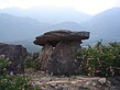
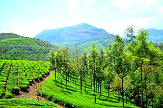
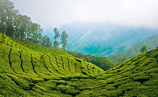
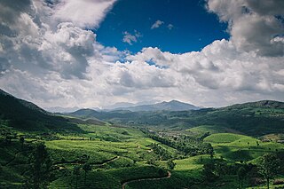
Munnar is a town and hill station located in the Idukki district of the southwestern Indian state of Kerala. Munnar is situated at around 1,600 metres (5,200 ft) above mean sea level, in the Western Ghats mountain range. Munnar is also called the "Kashmir of South India" and is a popular honeymoon destination.

<span class="mw-page-title-main">Idukki district</span> District in Kerala, India

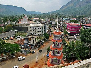
Idukki is one of the 14 districts in the Indian state of Kerala in the southwest of the country. It is the largest district in Kerala and lies amid the Cardamom Hills of Western Ghats in Kerala. Idukki district contains two municipal towns – Kattappana and Thodupuzha, and five taluks.

<span class="mw-page-title-main">Muvattupuzha</span> Municipality in Kerala, India

Muvattupuzha is a municipality in the Ernakulam district of Kerala, India. Muvattpuzha is located about 36 km (22.4 mi) east of Kochi and 189 km (117.4 mi) north of the state capital Thiruvananthapuram.

<span class="mw-page-title-main">Cardamom Hills</span> Mountain range in Kerala, India

The Cardamom Hills or Yela Mala are mountain range of southern India and part of the southern Western Ghats located in Idukki district, Kerala, India. Their name comes from the cardamom spice grown in much of the hills' cool elevation, which also supports pepper and coffee. The Western Ghats and Periyar Sub-Cluster including the Cardamom Hills are UNESCO World Heritage Sites.

<span class="mw-page-title-main">Anaimalai Hills</span> Mountain range in India

The Anamala or Anaimalai, also known as the Elephant Mountains, are a range of mountains in the southern Western Ghats of central Kerala and span the border of western Tamil Nadu in Southern India. The name anamala is derived from the Malayalam word aana and the Tamil word yaanai, meaning elephant, or from tribal languages. Mala or Malai means 'mountain', and thus literally translatable as 'Elephant mountain'.

<span class="mw-page-title-main">Manjampatti Valley</span>

Manjampatti Valley is a 110.9 km2 (42.8 sq mi) protected area in the eastern end of Indira Gandhi Wildlife Sanctuary and National Park (IGWS&NP) in Tirupur District, Tamil Nadu, South India. It is a pristine drainage basin of shola and montane rainforest with high biodiversity recently threatened by illegal land clearing and cultivation.

<span class="mw-page-title-main">Chinnar Wildlife Sanctuary</span> Wildlife sanctuary in South India

Chinnar Wildlife Sanctuary is located 18 km north of Marayoor on State Highway 17 in the Marayoor and Kanthalloor panchayats of Devikulam taluk in the Idukki district of India's Kerala state. It is one of 18 wildlife sanctuaries among the protected areas of Kerala.

<span class="mw-page-title-main">Anamudi Shola National Park</span> Protected area in Idukki district, Kerala, India

Anamudi Shola National Park is a protected area located along the Western Ghats of Idukki district in Kerala state, India. It is composed of Mannavan shola, Idivara shola and Pullardi shola, covering a total area of around 7.5 km². Draft notification of this new park was issued on 21 November 2003.

<span class="mw-page-title-main">Pambar River (Kerala)</span> River in Idukki district of Kerala, India

Pambar River originates near Anamudi in Idukki district of Kerala state in South India.

<span class="mw-page-title-main">Ramakkalmedu</span> Hill Station in Kerala, India

Ramakkalmedu is a hill station and a hamlet in Idukki district in the Indian state of Kerala. The place is noted for its panoramic beauty and numerous windmills.

<span class="mw-page-title-main">Pampadum Shola National Park</span> National park in India

Pampadum Shola National Park is the smallest national park in Idukki district of Kerala in India. It is on the border with Kodaikanal, Dindigul district of Tamil Nadu. The park is administered by the Kerala Department of Forests and Wildlife, Munnar Wildlife Division, together with the nearby Mathikettan Shola National Park, Eravikulam National Park, Anamudi Shola National Park, Chinnar Wildlife Sanctuary and the Kurinjimala Sanctuary. The park adjoins the Allinagaram Reserved Forest within the proposed Palani Hills Wildlife Sanctuary and National Park.It is a part of Palani hills stretched up to Vandaravu peak. The Westerns Ghats, Anamalai Sub-Cluster, including these parks, is under consideration by the UNESCO World Heritage Committee for selection as a World Heritage Site.

<span class="mw-page-title-main">Chinnar River</span> River in South India

The Chinnar River originates in the Annaimalai Hills below a grassy pass between the hills Kumarikkal Mala (8,275 ft) and Kaladekatti Malai In Idukki District, Kerala state South India. The 18 km long Chinnar river defines the East-West Tamil Nadu/Kerala state boundary along the northern edge of the Chinnar Wildlife Sanctuary and the southern edge of the Indira Gandhi Wildlife Sanctuary. Several adult crocodiles were reported in the Chinnar river in 1992.

<span class="mw-page-title-main">Neriamangalam</span> Village in Kerala, India

Neriamangalam is a village in Ernakulam district in the Indian state of Kerala. Neriamangalam is on the banks of Periyar River. It is on the border of Ernakulam and Idukki districts. Agriculture is the predominant occupation in this area. The Neriamangalam Bridge, Ranikallu etc. are of historical importance. The Neriamangalam Bridge, built across the Periyar river, is often referred as 'The Gateway to the Highranges' as it is on the way to the higher regions of Idukki district, especially Munnar. The bridge was made by the Maharaja of Travancore in 1935. Now the bridge is a part of National Highway 85 which leads to Dhanushkodi in Tamil Nadu. The St Joseph's church, Neriamangalam is a major place of worship for Syro-Malabar Christians of this region. The Jawahar Navodaya Vidyalaya, Neriamangalam is an important educational institution in this region.The nearest town is Kothamangalam, Neriamangalam gets one of the highest average rainfall in the state of Kerala. So this place is aptly hailed as 'The Cherrapunjee of Kerala'. The nearest town is Kothamangalam, which is about 17.6 km (11 mi) from Neriamangalam.

<span class="mw-page-title-main">Vattavada</span> Village in Kerala, India

Vattavada is a village in Idukki district in the state of Kerala, bordering Tamil Nadu, India. The village is located along Palani Hills in Western Ghats. It is an agricultural village known for growing a wide range of vegetables and fruits in the terrace farmlands.

<span class="mw-page-title-main">Adimali</span> Town in Kerala, India

Adimali is a town in the Idukki district of Kerala, in southwesternIndia. National Highway 185 is a highway in India running from Adimali to Kumily through Kattappana and ends in Adoor in Kerala. Adimaly is located on the National Highway 49, now NH 85, known as Kochi-Dhanushkodi National Highway, earlier known as the Kochi Madhura Highway (India) connecting Kochi and Madurai, India. From Adimaly, it is only 27 kilometers to Munnar, which is a famous hill station. The waterfalls Cheeyappara, Adimali waterfalls and Valara are located nearby. Pepper and cocoa cultivation is the main agricultural activity of this place. The Ponmudi Dam was constructed in 1963 across the Panniar river, nearly 15 km southeast of Adimali, on the way to Rajakkad.Thopramkudy is the nearest town. Adimali is known for its proximity to Munnar and natural environment. Adimali has almost all the basic facilities like roads, super markets, markets, educational institutions and hospitals.

<span class="mw-page-title-main">Suryanelli</span> Resort in Kerala, India

Suryanelli is a resort settlement in the Chinnakanal village in Idukki district, Kerala, India. Situated 40 km southeast of Munnar. It is surrounded by tea plantations and several resorts.

<span class="mw-page-title-main">Thopramkudy</span> Village in Kerala, India

Thopramkudy is a village in Vathikudy Gram panchayat, in Idukki Taluk located in Idukki district in the State of Kerala in South India. Spread over an area of 27.94 km2 (10.79 sq mi), it is one of the spices market in the state of Kerala. The town has a tropical climate with temperatures ranging from highs of 34.4 °C (93.9 °F) in the summer to a low of 18.5 °C (65.3 °F) in the winter, with a healthy rainfall of 3,040 mm (120 in). State Highway 40 (Kerala) and State Highway 42 (Kerala) and a new highway Kalvary Mount-Munnar is passing through Thopramkudy. The hamlet is mentioned in the 2009 Malayalam movie Loudspeaker

<span class="mw-page-title-main">Kolukkumalai</span> Village in Tamil Nadu, India

Kolukkumalai is a small village/hamlet in Bodinayakanur Taluk in the Theni district of the Indian state of Tamil Nadu. It is home to the highest tea plantation in the world with the tea grown here possessing a special flavour and freshness because of the high altitude. It is located near Munnar in Idukki district of Kerala.

<span class="mw-page-title-main">Edamalakkudy</span> Village in Kerala, India

Edamalakkudy, or Idamalakkudy, is a remote tribal village and gram panchayat between the Idamalayar Reserve Forest and Mankulam Forest Division of the Anaimalai Hills in the Idukki district of the Indian state of Kerala.

<span class="mw-page-title-main">Thoovanam Waterfalls</span> Waterfalls in Kerala, India

Thoovanam Falls is a waterfall located near Munnar, Idukki district, Kerala, India. It is located in within the Pambar river of Chinnar Wildlife Sanctuary at a distance of eight kilometers from the Marayur-Udumalai state highway. The waterfall falls from a height of 84 feet.

References

  1. "The Kerala Official Language (Legislation) Act, 1969" (PDF).
  2. "Table C-16 Population by Mother Tongue: Kerala". www.censusindia.gov.in. Registrar General and Census Commissioner of India.
  3. Government of Kerala, Panchayat statistics, 1991 Archived 2009-02-06 at the Wayback Machine
  4. https://censusindia.gov.in  › 3...PDF Web results Idukki - DISTRICT CENSUS HANDBOOK
  5. "Welcome to Marayoor Online". Marayoor.com. Retrieved 18 July 2016.
  6. "Unlocking the secrets of history". The Hindu . 6 December 2004. Archived from the original on 26 January 2005. Retrieved 18 July 2016.
  7. "News Archives". The Hindu . 13 September 2013. Archived from the original on 1 June 2011. Retrieved 18 July 2016.