Varkala is a major coastal municipality situated in the northern suburb of Thiruvananthapuram, capital city of the Indian state of Kerala.

Kollam, also known by its former name Quilon, is an ancient seaport and city on the Malabar Coast of India bordering the Laccadive Sea, which is a part of the Arabian Sea. It is 71 km (44 mi) north of the state capital Thiruvananthapuram. The city is on the banks of Ashtamudi Lake and the Kallada river. Kollam is the fourth largest city in Kerala and is known for cashew processing and coir manufacturing. It is the southern gateway to the Backwaters of Kerala and is a prominent tourist destination. Kollam is one of the most historic cities with continuous settlements in India. Geographically, Quilon formation seen around coastal cliffs of Ashtamudi Lake, represent sediments laid down in the Kerala basin that existed during Mio-Pliocene times.

The Kerala backwaters are a network of brackish lagoons and canals lying parallel to the Arabian Sea of the Malabar coast of Kerala state in south-western India. It also includes interconnected lakes, rivers, and inlets, a labyrinthine system formed by more than 900 km (560 mi) of waterways, and sometimes compared to bayous. The network includes five large lakes linked by canals, both man made and natural, fed by 38 rivers, and extending virtually half the length of Kerala state. The backwaters were formed by the action of waves and shore currents creating low barrier islands across the mouths of the many rivers flowing down from the Western Ghats range. In the midst of this landscape there are a number of towns and cities, which serve as the starting and end points of backwater cruises. There are 34 backwaters in Kerala. Out of it, 27 are located either closer to Arabian Sea or parallel to the sea. The remaining 7 are inland navigation routes.

Ashtamudi Lake, in the Kollam District of the Indian state of Kerala. It possesses a unique wetland ecosystem and a large palm-shaped water body, second only in size to the Vembanad estuary ecosystem of the state. Ashtamudi means 'eight hills or peaks' in the local Malayalam language. The name is indicative of the lake's topography with its multiple branches. The lake is also called the gateway to the backwaters of Kerala and is well known for its houseboat and backwater resorts. Ashtamudi Wetland was included in the list of wetlands of international importance, as defined by the Ramsar Convention for the conservation and sustainable utilization of wetlands.
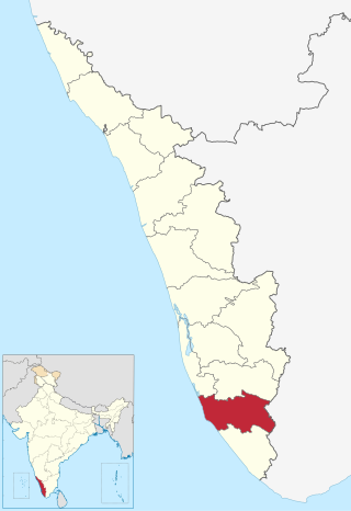
Kollam district, is one of 14 districts of the state of Kerala, India. The district has a cross-section of Kerala's natural attributes; it is endowed with a long coastline, a major Laccadive Sea seaport and an inland lake. The district has many water bodies. Kallada River is one among them, and land on the east bank of the river is East Kallada and that on the west bank is West Kallada.

Munroe Island or Mundrothuruthu is an inland island group located at the confluence of Ashtamudi Lake and the Kallada River, in Kollam district, Kerala, South India. It is a group of eight small islets comprising a total area of about 13.4 km2. The island, accessible by road, rail and inland water navigation, is about 25 kilometres (16 mi) from Kollam by road, 38 kilometres (24 mi) north from Paravur, 12 kilometres (7.5 mi) west from Kundara and about 25 kilometres (16 mi) from Karunagapally. As of the 2011 Indian census, the administrative village of Mundrothuruth has a total population of 9599, consisting of 4636 males and 4963 females. This island is also known as "Sinking Island of Kerala"

Kerala, a state situated on the tropical Malabar Coast of southwestern India, is one of the most popular tourist destinations in the country. Named as one of the ten paradises of the world by National Geographic Traveler, Kerala is famous especially for its ecotourism initiatives and beautiful backwaters. Its unique culture and traditions, coupled with its varied demography, have made Kerala one of the most popular tourist destinations in the world. Several international agencies ranging from UNESCO to National Geographic have recognised the state's tourism potential. Kerala was named by TIME magazine in 2022 among the 50 extraordinary destinations to explore in its list of the World's Greatest Places. In 2023, Kerala was listed at the 13th spot in The New York Times' annual list of places to visit and was the only tourist destination listed from India.
Karunagappally is a municipality in the Kollam district of Kerala, India. It is 24 km north of Kollam and 60 km (37 mi) south of Alappuzha. Karunagappally taluk consists of Alappad, Ochira, Adinad, Karunagappally, Thazhava, Pavumba, Thodiyoor, Kallalibhagom, Thevalakkara, Chavara, Neendakara, Clappana, Kulasekharapuram, Thekkumbhagam, Ayanivelikulangara, Panmana, Ponmana and Vadakumthala. The taluk is bound on the north by Kayamkulam, on the east by Kunnathur taluk, on the south by Kollam and on the west by the Arabian Sea. It is one of the fastest developing towns in Kerala and is part of Kollam metropolitan area.
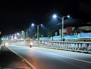
Kundara is a census town in Kerala and is part of the Kollam Metropolitan Area, India. Kundara is situated 13 km east of Kollam city, 14 km west of Kottarakkara, and 24 km north of Paravur. Kundara is significant for its historic involvement in the Indian independence movement.

The President's Trophy Boat Race is a popular boat race held on the Ashtamudi lake in Kollam city on 1 November every year. The day marks the birth of the Indian state of Kerala, known as Kerala Piravi. This is the most popular of the races to be held during the season of the harvest festival, Onam, in Autumn on Ashtamudi Lake in Kollam. There would be races in five categories, namely Chundan Vallam (snake-boats), two grades of Veppu Vallam, and two grades of Iruttukuthi Vallam. Sixteen snake-boats would compete in four heats. The trophy had been instituted in the name of the President of India. President of India will be present to witness the race and would also give away the trophy and cash prize to the winning team. The race will become a part of Kerala's IPL-model boat race league from 2019 onward. The Government of Kerala is planning to make President's Trophy Boat Race as the finishing event of Champions’ Boat League.

Kollam Beach, also known as Mahatma Gandhi Beach, is a beach at Kollam city in the Indian state of Kerala. Kollam Beach is the first 'Beach Wedding Destination' in Kerala.
Sakthikulangara is a zone and neighbourhood situated at the coastal area of the city of Kollam in Kerala India. It is one among the 6 zonal headquarters of Kollam Municipal Corporation.

Chettuva Backwater or Lanchi Velayudhan's Chettuva is located in between Engandiyur Panchayat and Kadappuram Panchayat of Thrissur District in Kerala. The backwaters start at Enamakkal Lake and empties to Arabian Sea. The destination is blessed with mangroves, Chinese fishing nets, islands, migratory birds, estuary and a fort. The mangroves at Chettuva backwaters are famous around the world, it is also knows as Lanchi Velayudhan backwater, He have helped many to reach in Dubai in 90's with his boat. In 2010, Government of Kerala has declared Chettuva as heritage village.

Thekkumbhagam or Thekkumbhagom is the southern border town of Paravur municipality in the Kollam district of Kerala, India. It is located at the Southern tip of Kollam's coastal area. It is in the Arabian Sea coast. Thekkumbhagam-Kappil estuary point in the Kollam-Thiruvananthapuram coastal border is one of the emerging tourism spots in the state. On 1936, during formation, Thekkumbhagam was one of the nine territories of Paravur Panchayath. Thekkumbhagam estuary is one among the twin estuary points in Paravur. The other one is Pozhikara estuary.

Asramam Adventure Park is an urban park in the core Kollam city of Kerala state. It was opened after 1980, on 48 acres (19 ha) of city-owned land. Located beside the Kerala's pride, backwaters of Ashtamudi, this place popularly known as Asramam Picnic Village. It is the main centre of recreational activities in Kollam city. The Kollam District Tourism Promotion Council conducts regular backwater cruises in houseboats, luxury boats and speedboats from the Boat Club. The mangroves near this park is very famous in all over India. So many endangered species of trees are surviving in the park.
Kollam or Quilon is an old seaport and a city on the Laccadive Sea coast in Kerala, India, on Ashtamudi Lake. The city remains notable as the ancient commercial capital of Kerala and the southwestern Indian coast, in addition to its fame as the "Cashew Capital of the World". The Kollam Municipal Corporation has the second largest budget in Kerala in terms of revenue and expenditure.

Kollam KSWTD Boat Jetty or Kollam KSWTD Ferry Station is an transport hub in the city of Kollam in Kerala, India, one of 14 ferry stations owned by the Kerala State Water Transport Department.

City of Kollam or Quilon is known as Prince of Arabian Sea, situated on the banks of Arabian Sea and Ashtamudi Lake. A major portion of Kollam Municipal Corporation area is occupied by Ashtamudi Lake. It is the most visited backwater and lake of Kerala, with a unique wetland ecosystem, a palm-shaped large water body, next only to the Vembanad estuary ecosystem of the state. Ashtamudi means 'eight coned'(Ashta = 'eight'; mudi = 'coned') in the local language of Malayalam. This name is indicative of the lake's topography: a lake with multiple branches. The lake is also called the gateway to the backwaters of Kerala. This lake is extremely famous for House Boat and Backwater Resorts.

The Paravur Estuaries are a group of estuaries in Paravur, India, near the South-Western coast of Kollam district, Kerala. Paravur is one among the 4 municipal towns in Kollam district, Kerala state. The place is known for its natural beauties, backwater locations, white-sand beaches and concentration of temples.
Sambranikodi Island is a landmass situated in the Ashtamudi backwaters of Kollam district, Kerala, India. The island is situated approximately 10 kilometers away from the main city of Kollam. The village falls in the area of ward 13 of Thrikkaruva grama panchayat and is at the southern tip of Prakkulam. The island in the lake can be accessed from Sambranikodi in mainland via boats services.


