
Kochi, also known by its former name Cochin, is a major port city along the Malabar Coast of India bordering the Laccadive Sea. It is part of the district of Ernakulam in the state of Kerala. The city is also commonly referred to as Ernakulam. As of 2011, the Kochi Municipal Corporation had a population of 677,381 over an area of 94.88 km2, and the larger Kochi urban agglomeration had over 2.1 million inhabitants within an area of 440 km2, making it the largest and the most populous metropolitan area in Kerala. Kochi city is also part of the Greater Cochin development region and is classified as a Tier-II city by the Government of India. The civic body that governs the city is the Kochi Municipal Corporation, which was constituted in the year 1967, and the statutory bodies that oversee its development are the Greater Cochin Development Authority (GCDA) and the Goshree Islands Development Authority (GIDA).
Ernakulam is one of the 14 districts in the Indian state of Kerala, and takes its name from the eponymous city division in Kochi. It is situated in the central part of the state, spans an area of about 2,924 square kilometres (1,129 sq mi), and is home to over 9% of Kerala's population. Its headquarters are located at Kakkanad. The district includes Kochi, also known as the commercial capital of Kerala, which is famous for its ancient churches, Hindu temples, synagogues and mosques.

Kollam, also known by its former name Quilon, is an ancient seaport and city on the Malabar Coast of India bordering the Laccadive Sea, which is a part of the Arabian Sea. It is 71 km (44 mi) north of the state capital Thiruvananthapuram. The city is on the banks of Ashtamudi Lake and the Kallada river. Kollam is the fourth largest city in Kerala and is known for cashew processing and coir manufacturing. It is the southern gateway to the Backwaters of Kerala and is a prominent tourist destination. Kollam is one of the most historic cities with continuous settlements in India. Geographically, Quilon formation seen around coastal cliffs of Ashtamudi Lake, represent sediments laid down in the Kerala basin that existed during Mio-Pliocene times.

Periyar, IPA:[peɾijɐːr], is the longest river and the river with the largest discharge potential in the Indian state of Kerala. It is one of the few perennial rivers in the region and provides drinking water for several major towns. The Periyar is of utmost significance to the economy of Kerala. It generates a significant proportion of Kerala's electrical power via the Idukki Dam and flows along a region of industrial and commercial activity. The river also provides water for irrigation and domestic use throughout its course besides supporting a rich fishery. Due to these reasons, the river has been named the "Lifeline of Kerala". Kochi city, in the vicinity of the river mouth, draws its water supply from Aluva, an upstream site sufficiently free of seawater intrusion. Twenty five percent of Kerala's industries are along the banks of the Periyar. These are mostly crowded within a stretch of 5 kilometres (3 mi) in the Eloor-Edayar region (Udhyogamandal), about 10 kilometres (6 mi) north of Kochi harbor.
Pothundi Dam is an irrigation dam near Pothundi village in the Palakkad district of Kerala state, India. Constructed in the 19th century, it is considered one of the oldest dams in India. It provides irrigation to an area of 5,470 hectares in the Palakkad district and drinking water supply to the Nemmara, Ayalur, Melarcode Panchayat. An unusual feature of the earth dam is the core wall, which is built with a mixture of jaggery and quick lime.

Chalakudy River or Chalakudy Puzha is the fifth longest river in Kerala, India. The river flows through Thrissur district, Palakkad district and Ernakulam district of Kerala. The total drainage area of the river is 1704 km2. Out of this,1404 km2 lies in Kerala and the rest in Tamil Nadu. The length of the river is 145.5 km. Though Chalakudy River in strict geological sense is a tributary of the Periyar river, for all practical purposes it is treated as a separate river by Government and other agencies. The river has gained its name since it flows along the banks of the Chalakudy Town, the major settlement along the course of the river. It is perhaps the most unpolluted and pristine river in the state and even in India due to the limited amount of industries and wastage disposal around it. Chalakudy River and its basin area were one of the most affected rivers during the 2018 Kerala floods.

Ernakulam is the central business district of the city of Kochi, Kerala, India. It is the namesake of Ernakulam district. The eastern part of Kochi city is mainly known as Ernakulam, while the western part of it after the Venduruthy Bridge is called as Western Kochi. Many major establishments, including the Kerala High Court, the office of the Kochi Municipal Corporation and the Cochin Shipyard are situated in Ernakulam. It is also the most urbanized area in the city of Kochi.

The Kochi Municipal Corporation is the municipal corporation that manages the Indian city of Kochi in the state of Kerala. The Corporation manages 94.88 km2 of Kochi city and has a population of 677,381 within that area. It is the most densely populated city corporation in the state. Kochi Municipal Corporation has been formed with functions to improve the infrastructure of town.
The Central Marine Fisheries Research Institute was established in the government of India on 3 February 1947 under the Ministry of Agriculture and Farmers Welfare and later, in 1967, it joined the Indian Council of Agricultural Research (ICAR) family and emerged as a leading tropical marine fisheries research institute in the world. The Headquarters of the ICAR-CMFRI is located in Kochi, Kerala. Initially the institute focused its research efforts on creating a strong database on marine fisheries sector by developing scientific methodologies for estimating the marine fish landings and effort inputs, taxonomy of marine organisms and the biological aspects of the exploited stocks of finfish and shellfish on which fisheries management were to be based. This focus contributed significantly to development of the marine fisheries sector from a predominantly artisanal, sustenance fishery till the early sixties to that of a complex, multi-gear, multi-species fisheries.
Kochi is a major port city in the Indian state of Kerala. The city is widely known as the commercial or economic capital of the state of Kerala.

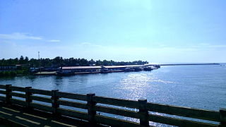
The West Coast Canal or National Waterway No 3 is a 205 km (127 mi) long inland navigational route located in Kerala, India, which runs from Kollam to Kottapuram. It was declared a National Waterway in 1993. In addition to the main stretch, Champakara and Udyogmandal canals are navigable and connect the industrial centers of Kochi to Kochi port Inland Waterways Authority of India (IWAI) under the Ministry of Shipping is coordinating the task for developing, monitoring and administering national waterways. It is the first National Waterway in the country with 24-hour navigation facilities along the entire stretch. It has been extended to Kozhikode by the National Waterways Act, 2016. The National Waterway 3 mainly passes through the previous Thiruvananthapuram–Shoranur canal.
Neendakara is a suburb of Kollam city in Kerala, India .The twin harbours, Neendakara and Shakthikulangara are located here. |url=https://www.tourmyindia.com/states/kerala/neendakara-port-kollam.html Trawling ban and withdrawal of the state official start from Neendakara harbour. It is about 10km away from the city center.

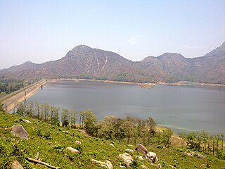
Idamalayar Dam is a multipurpose concrete gravity dam located at Ennakkal between Ayyampuzha and Bhoothathankettu in Ernakulam district of Kerala on the Idamalayar, a tributary of the Periyar River in Kerala, South India. The dam however extends east as far as Malakkappara. Completed in 1985, with a length of 373 metres (1,224 ft) and a height of 102.8 metres (337 ft), the dam created a multipurpose reservoir covering 28.3 km2 (10.9 sq mi) in the scenic hills of the Anamalais.

Angamaly for Kalady is an NSG–4 category Amruth Bharat Railway Station Amrit Bharat Station Scheme Indian railway station in Thiruvananthapuram railway division of Southern Railway zone. It is a railway station Located at Angamaly in Ernakulam district of Kerala state in India operated by Southern Railway Network. It lies in the Shoranur–Cochin Harbour section of Trivandrum division. Angamaly is the halting point for 48 trains including Express and all Passenger trains passing through this station. The railway station is located about 26 km from Ernakulam Town and 10 km from Aluva stations. It Is the nearest railway station of Cochin International Airport, 5 KM apart, where above 10 million passengers traveling every year.

K. Babu is an Indian politician and the former Minister for Fisheries, Ports and Excise, Government of Kerala. He is the representative of Thripunithura constituency in Kerala from 1991 to 2016 and again from 2021.
Sakthikulangara is a zone and neighbourhood situated at the coastal area of the city of Kollam in Kerala India. It is one among the 6 zonal headquarters of Kollam Municipal Corporation.
Pallithode is a village in the Alappuzha district, in the state of Kerala, India, on the shores of the Arabian Sea. Pallithode is within the Gram Panchayat of Kuthiathode, Pattanakad Block, of Cherthala Taluk. During the 20th century, more than half of its width was eroded away by the action of river backwaters and the sea. The village is very densely populated and has a wet, maritime tropical climate. It has an important role in the fishing industry.

Pizhala is an island village, one among the fourteen islands of Kadamakkudy archipelago, located near to the main land of the city Ernakulam. The island is surrounded by tributaries of river Periyar. Pizhala island is part of Kadamakkudy village of Kanayannur taluk in Ernakulam district in the state of Kerala, India.

Prof. (Dr) B. Madhusoodana Kurup is an Indian fisheries researcher, academic and administrator. He is the Founder Vice-Chancellor of Kerala University of Fisheries and Ocean Studies (KUFOS), Cochin and also served as the third Vice Chancellor of Shri Venkateshwara University, Gajraula, Uttar Pradesh. He has established and successfully developed the first Fisheries and Ocean Sciences University in the country. He did his postdoc from Fish Culture and Fisheries division, Wageningen University & Research, The Netherlands. He served as UGC Professor (Fisheries) at Cochin University of Science and Technology (CUSAT) for over eighteen years.
Narayana Balakrishnan Nair (1927–2010) was a marine biologist, ecologist and the founder president of Kerala Science Congress. He was known for his advocacy of trawling ban during monsoon seasons which was later accepted and imposed by the Government of Kerala. A Jawaharlal Nehru fellow, Nair was an elected fellow of all the major Indian science academies as well as the Zoological Society of London. The Council of Scientific and Industrial Research, the apex agency of the Government of India for scientific research, awarded him the Shanti Swarup Bhatnagar Prize for Science and Technology, one of the highest Indian science awards, in 1971, for his contributions to biological sciences. He received the fourth highest Indian civilian honor of the Padma Shri in 1984.

