Kochi, also known as Cochin is a major port city on the Malabar Coast of India bordering the Laccadive Sea, which is a part of the Arabian Sea. It is part of the district of Ernakulam in the state of Kerala and is commonly referred to as Ernakulam. Kochi is the most densely populated city in Kerala. As of 2011, it has a corporation limit population of 677,381 within an area of 94.88 km2 and a total urban population of more than of 2.1 million within an area of 440 km2, making it the largest and the most populous metropolitan area in Kerala. Kochi city is also part of the Greater Cochin region and is classified as a Tier-II city by the Government of India. The civic body that governs the city is the Kochi Municipal Corporation, which was constituted in the year 1967, and the statutory bodies that oversee its development are the Greater Cochin Development Authority (GCDA) and the Goshree Islands Development Authority (GIDA).

Ernakulam, IPA: [erɐɳɐːguɭɐm]; ISO: Eṟaṇākuḷaṁ, in Malayalam: എറണാകുളം), is one of the 14 districts in the Indian state of Kerala, that takes its name from the eponymous city division in Kochi. It is situated in the central part of the state, spans an area of about 3,000 square kilometres (1,200 sq mi), and is home to over 9% of Kerala's population. Its headquarters are located at Kakkanad. The district includes Kochi, also known as the commercial capital of Kerala, which is famous for its ancient Churches, Hindu temples, synagogues and mosques. The district includes the largest metropolitan region of the state: Greater Cochin. Ernakulam is the district that yields the most revenue and the largest number of industries in the state. Ernakulam is the third most populous district in Kerala, after Malappuram and Thiruvananthapuram. The district also hosts the highest number of international and domestic tourists in Kerala state.

Kollam, also known by its former name Quilonpronunciation (help·info), is an ancient seaport and city on the Malabar Coast of India bordering the Laccadive Sea, which is a part of the Arabian Sea. It is 71 km (44 mi) north of the state capital Thiruvananthapuram. The city is on the banks of Ashtamudi Lake and the Kallada river. It is the headquarters of the Kollam district. Kollam is the fourth largest city in Kerala and is known for cashew processing and coir manufacturing. It is the southern gateway to the Backwaters of Kerala and is a prominent tourist destination.

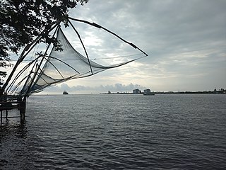
The Kerala backwaters are a network of brackish lagoons and lakes lying parallel to the Arabian Sea coast of Kerala state in southern India, as well as interconnected canals, rivers, and inlets, a labyrinthine system formed by more than 900 kilometres (560 mi) of waterways, and sometimes compared to American bayous. The network includes five large lakes linked by canals, both man made and natural, fed by 38 rivers, and extending virtually half the length of Kerala state. The backwaters were formed by the action of waves and shore currents creating low barrier islands across the mouths of the many rivers flowing down from the Western Ghats range. In the midst of this landscape there are a number of towns and cities, which serve as the starting and end points of backwater cruises. There are 34 backwaters in Kerala. Out of it, 27 are located either closer to Arabian Sea or parallel to the sea. The remaining 7 are inland navigation routes.
Kollam district, is one of 14 districts of the state of Kerala, India. The district has a cross-section of Kerala's natural attributes; it is endowed with a long coastline, a major Laccadive Sea seaport and an inland lake. The district has many water bodies. Kallada River is one among them, and the east side land of river is East Kallada and the west side land is West Kallada.

Munroe Island or Mundrothuruthu is an inland island group located at the confluence of Ashtamudi Lake and the Kallada River, in Kollam district, Kerala, South India. It is a group of eight small islets comprising a total area of about 13.4 km2. The island, accessible by road, rail and inland water navigation, is about 25 kilometres (16 mi) from Kollam by road, 38 kilometres (24 mi) north from Paravur, 12 kilometres (7.5 mi) west from Kundara and about 25 kilometres (16 mi) from Karunagapally. As of the 2011 Indian census, the administrative village of Mundrothuruth has a total population of 9599, consisting of 4636 males and 4963 females. This island is also known as "Sinking Island of Kerala"
Fort Kochi, Fort Cochin in English, Cochim de Baixo in Cochin Portuguese creole, is a neighbourhood of Cochin (Kochi) city in Kerala, India. Fort Kochi takes its name from the Fort Manuel of Cochin, the first European fort on Indian soil, controlled by the Portuguese East Indies. This is part of a handful of water-bound islands and islets toward the south-west of the mainland Kochi, and collectively known as Old Cochin or West Cochin. Adjacent to this is the locality of Mattancherry. In 1967, these three municipalities along with a few adjoining areas, were amalgamated to form the Corporation of Cochin.

Kerala is a state on the Malabar Coast of India. It was formed on 1 November 1956, following the passage of the States Reorganisation Act, by combining Malayalam-speaking regions of the erstwhile regions of Cochin, Malabar, South Canara, and Travancore. Spread over 38,863 km2 (15,005 sq mi), Kerala is the 21st largest Indian state by area. It is bordered by Karnataka to the north and northeast, Tamil Nadu to the east and south, and the Lakshadweep Sea to the west. With 33 million inhabitants as per the 2011 census, Kerala is the 13th-largest Indian state by population. It is divided into 14 districts with the capital being Thiruvananthapuram. Malayalam is the most widely spoken language and is also the official language of the state.

Kallada River/Kulathupuzha " Puzha "means River.Its's the longest river in Kollam District, Kerala, India.The river originates in Kulathupuzha,a part of Western Ghats and flows west reaching Arabian Sea after travelling a distance of 120km.
Koduvila is a village near Ashtamudi Lake in East-Kallada, Kollam district, Kerala, India. It shares a boundary with Sinkarappally and Munroe Island, and is near Chittumala.

Kerala has a reputation of being, communally, one of the most religiously diverse states in India. According to 2011 Census of India figures, 54.73% of Kerala's population are Hindus, 26.56% are Muslims, 18.38% are Christians, and the remaining 0.33% follow other religions or have no religion. Hindus represent the biggest religious group in all districts except Malappuram, where they are outnumbered by Muslims. Various tribal people in Kerala have retained the religious beliefs of their ancestors. In comparison with the rest of India, Kerala experiences relatively little sectarianism.
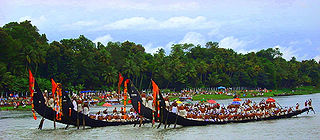
The Kallada Jalotsavam is a popular Vallam Kali held on the Kallada River at Munroe Thuruthu on 28 days after Onam in Indian state of Kerala. The boat race is conducted along the straight portion (nettayam) of Kallada River. Famous achievers in various fields are honoured during the event.

Pizhala is an island near Kochi surrounded by river Periyar. It is the central part and Capital of Kadamakkudy Grama Panchyath, Kanayannur Taluk, Ernakulam District in the Indian state of Kerala. The name Pizhala is derived from the Portuguese words paz na ilha, which mean 'peace on island'. Pizhala island was formed naturally due to the great floods of Periyar in 1341 AD, which choked the Muziris Port, one of the greatest ports in Ancient World.

Munroturuttu railway station or Mundrothuruthu railway station(Code:MQO) is an 'HG 2 Category' halt railway station, situated between Perinad and Sasthamkotta railway stations of Kollam district in Kerala state, India. The station is coming under the Southern Railway zone of Indian Railways. The nearest major rail head of Munrothuruthu railway station is Kollam Junction railway station.

Kollam KSWTD Boat Jetty or Kollam KSWTD Ferry Station is an transport hub in the city of Kollam in Kerala, India, one of 14 ferry stations owned by the Kerala State Water Transport Department.

City of Kollam or Quilon is known as Prince of Arabian Sea, situated on the banks of Arabian Sea and Ashtamudi Lake. A major portion of Kollam Municipal Corporation area is occupied by Ashtamudi Lake. It is the most visited backwater and lake of Kerala, with a unique wetland ecosystem, a palm-shaped large water body, next only to the Vembanad estuary ecosystem of the state. Ashtamudi means 'eight coned'(Ashta = 'eight'; mudi = 'coned') in the local language of Malayalam. This name is indicative of the lake's topography: a lake with multiple branches. The lake is also called the gateway to the backwaters of Kerala. This lake is extremely famous for House Boat and Backwater Resorts.
Quilon or Coulãopronunciation (help·info), officially Kollampronunciation (help·info) is one of the ancient civilizations in India.It is one of the oldest port cities in the Malabar Coast and was the capital city of historic Venad Kingdom and Travancore Kingdom. Quilon was once an important trading port in India. It was also known as Desinganadu. It is now known as the "Cashew Capital of the World".

City of Kollam or Quilon is a Port city in South India and was the commercial capital of erstwhile Kingdom of Travancore. It is situated on the Laccadive Sea coast of South Kerala. The city is known as the "Gateway to the backwaters of Kerala". The city lies on the banks of Ashtamudi Lake, Kerala's second largest lake, on the Arabian sea coast. Major parts of Kollam city are covered by Ashtamudi Lake.

The Kannur Corporation, also known as Corporation of Cannanore, is the municipal corporation that administers the city of Kannur (Cannanore), Kerala. Established in 2015, the Corporation's first mayor was E. P. Latha. Kannur Corporation has two assembly constituencies – Kannur and Azhikode – both of which are part of the Kannur parliamentary constituency. The Corporation is headed by a Mayor and council, and manages 78.35 km2 of Kannur city, with a population of about 232,486 within that area. Kannur Municipal Corporation has been formed with functions to improve the infrastructure of town.