
Pathanamthitta District, is one of the 14 districts in the Indian state of Kerala. The district headquarters is in the town of Pathanamthitta. There are four municipalities in Pathanamthitta: Adoor, Pandalam, Pathanamthitta and Thiruvalla.

Kanjirappally is a taluk and a town in Kottayam district situated about 38 km (24 mi) away from the district capital, in the state of Kerala, in southwestern India.
Mundakayam, is a town in Kanjirappally Taluk in the Kottayam District of Kerala. It is the doorway to the high ranges of southern Kerala, and is at the border of Kottayam and Idukki districts. The next nearest town, Kanjirappally, is 14 km (8.7 mi) & Erumely is 12 km from Mundakayam. Mundakayam has rubber plantations, and greenery. The Manimala River runs through Mundakayam. It is located 48 km east of the district headquarters at Kottayam and 148 km from the state capital, Thiruvananthapuram. The name Mundakayam is said to be derived from the Mundi cranes that used to be seen along the Manimala River banks.
Adoor is a municipality in the Pathanamthitta district of Kerala, India. It is the headquarters of the Adoor Taluk and Adoor Revenue Division. Adoor is located 13.2 km (8.2 mi) southwest of the district headquarters Pathanamthitta and 78.1 km (48.5 mi) north of the state capital Thiruvananthapuram.
The Main Central Road popularly known as MC Road is the arterial State Highway starting from Kesavadasapuram in Trivandrum city and ends at Angamaly, a suburb of Kochi city in Ernakulam District, in the state of Kerala, India. It is designated as State Highway 1 by the Kerala Public Works Department. The highway was built by Raja Kesavadas, Dewan of Travancore, in the 1790s. Plan for a new highway called Thiruvananthapuram–Angamaly Greenfield Highway, which runs parallel to the MC Road is proposed and is under early stage of development.

Kottarakkara, also transliterated as Kottarakara, is a town and municipality in the Kollam district of the Kerala, India. The town is close to Kollam Port, which has a rich history linked to the early medieval period as well as the reputation as an important commercial, industrial and trading center. Kottarakkara lies 27 kilometres (17 mi) to the east of Kollam city centre.

Ponkunnam is a census town in Kerala, India, part of Kottayam district under Kanjirappally taluk. Ponkunnam literally means golden mountain (ponn = gold, kunn = mountain). Nearby towns are Kanjirappalli, Manimala and Pala. This part of Kerala is famous for its fertile land and rubber plantations. It is at an altitude of 495 ft (151 m) above mean sea level. The town is at the junction of two major roads in Kerala: NH 183 and Main Eastern Highway. The climate is moderate with timely cold breezes and the town is the gateway to the Western Ghats. The town is famous for its volleyball traditions and customs. Almost every year there is an ever-rolling volleyball tournament happening in Ponkunnam Mahatma Gandhi Mini Stadium.

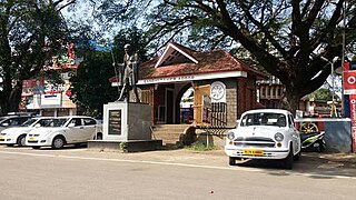
Pathanamthitta, is a municipality situated in the Southern Kerala, India, spread over an area of 23.50 km2. It is the administrative capital of Pathanamthitta district. The town has a population of 37,538. The Hindu pilgrim centre Sabarimala is situated in the Pathanamthitta district; as the main transport hub to Sabarimala, the town is known as the 'Pilgrim Capital of Kerala'. Pathanamthitta District, the thirteenth revenue district of the State of Kerala, was formed with effect from 1 November 1982, with headquarters at Pathanamthitta. Forest covers more than half of the total area of the District. Pathanamthitta District ranks the 7th in area in the State. The district has its borders with Allepey, Kottayam, Kollam and Idukki districts of Kerala and Tamil Nadu. Nearest city Is Thiruvalla, located at a distance of 30 km. Thiruvalla railway station Is 30 km via Thiruvalla-Kumbazha highway. Buses ply every 5 Minutes from Thiruvalla To Pathanamthitta & vice versa.

Kumily, also spelt as Kumaly is a revenue village and Gram Panchayat in the Idukki district of the state of Kerala. It is a town in Cardamom Hills near Thekkady and Periyar Tiger Reserve. Kumily is a gateway town into Kerala from Tamil Nadu.

The Main Eastern Highway is the lifeline of the high range townships of the Travancore region of Kerala state, India. It is also known as Punalur-Muvattupuzha Highway. Main Eastern Highway is categorized as State Highway - 08 of Kerala. It is the second longest State Highway of Kerala covering a distance of 153.6 km. The districts it passes through are Kollam, Pathanamthitta, Kottayam, Idukki and Ernakulam.

Yendayar is a village in Kottayam district, Kerala, India that is totally surrounded by hills. According to local tradition, Mr. J.J. Murphy named the place, which was to be his home until death in 1957, after his mother and the local river. Yendayar is a combination of 'yen' (my) 'thai' (mother) and 'ar' (river). Murphy had come in 1904 to the place which was a thick forest and had no name or people then. He had traveled a long way to reach there. There he established India's first successful rubber plantation. He brought workers from near and far – Kerala, Tamil Nadu, and Karnataka.
Kaipattoor is a small town in Vallicode panchayat of Pathanamthitta district in Kerala, India. Kaipattoor is located in the western part of Pathanamthitta district. It is 6 kilometers from the district headquarters Pathanamthitta at south east direction. It is watered by the Achenkovil river. The village is under Vallicode Panchayat.

The SH-07 / T.K.Road is the life line of the Central Travancore.
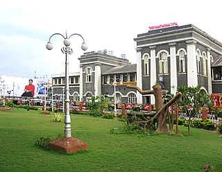
Thiruvananthapuram Railway Division (TVC) or Trivandrum Railway Division(TVC) is one of the six administrative divisions of the Southern Railway, Indian Railways. It has its headquarters at Thiruvananthapuram, the capital city of the state of Kerala, India. Thiruvananthapuram Division was formed on 2 October 1979which serves the eight districts of southern part of the Kerala, Kanniyakumari district and some parts of Tirunelveli District in Tamil Nadu. With 104 stations in its territorial jurisdiction, it is the fourth largest out of six divisions in Southern Railway. It is the southernmost railway division of India and manages 625 km of route track and 108 railway stations in the states of Kerala and Tamil Nadu. The major stations of the division are Thiruvananthapuram Central, Ernakulam Junction, Kollam Junction, Thrissur, Kottayam, Ernakulam Town, Chengannur, Kayamkulam, Aluva, Nagercoil Junction, Kanniyakumari,Changanasseri, Tiruvalla, Kochuveli, Varkala,Mavelikara,Karunagappally.

This article gives a list of the territories of the dioceses of the Catholic Church in India.
National Highway 183A, also known as NH 183A, is a National Highway in the Indian state of Kerala that runs from Chavara Titanium Junction, Kollam, to Vandiperiyar via Adoor and Pathanamthitta. It is the 4th National Highway passing through the Kollam district.

Transport in Kollam includes various modes of road, rail and water transportation in the city and its suburbs. State-owned Kerala State Road Transport Corporation buses, private buses, Indian Railways, state-owned Kerala State Water Transport Department boats & ferry, taxis and auto rickshaws are serving the city of Kollam. The city had a strong commercial reputation since the days of the Phoenicians and Romans. Ibn Battuta mentioned Kollam Port as one of the five Indian ports he had seen during the course of his twenty-four year travels.
Koruthodu is a village/town in Kanjirappally Taluk, Kottayam District of Kerala state, India. It is situated on the Highway connecting Mundakayam to Sabarimala temple, Kerala, and is at the border of Pathanamthitta, Kottayam and Idukki districts. The nearest town Mundakayam is 13 Kilometers from Koruthodu. The river Azhutha runs through the borders of this village. Nearby locations include Kanamala, Vandanpathal, Mundakkayam and Panakkachira.

National Highway 83 is a primary national highway in India. NH-83 runs in an east-west direction, entirely within the state of Tamil Nadu in India. 4-laning of Pollachi to Dindigul stretch was approved in 2018.

The Ernakulam–Kottayam–Kayamkulam line is a railway line which runs through the districts of Ernakulam, Kottayam, Pathanamthitta and Alappuzha in Kerala state of India. This railway line starts as a branch line from Ernakulam Town railway station towards Kottayam and joins with the Ernakulam–Kayamkulam coastal line route via Alappuzha at Kayamkulam Junction. This line comes under the Thiruvananthapuram railway division of Southern Railway Zone of Indian Railways. The line has a total distance of 118 km (73 mi). The Ernakulam Town/Ernakulam Junction - Kottayam section opened in 1956-57 and Kottayam - Kollam section in 1957.


