
India lies on the Indian Plate, the northern part of the Indo-Australian Plate, whose continental crust forms the Indian subcontinent. The country is situated north of the equator between 8°4' north to 37°6' north latitude and 68°7' east to 97°25' east longitude. It is the seventh-largest country in the world, with a total area of 3,287,263 square kilometres (1,269,219 sq mi). India measures 3,214 km (1,997 mi) from north to south and 2,933 km (1,822 mi) from east to west. It has a land frontier of 15,200 km (9,445 mi) and a coastline of 7,516.6 km (4,671 mi).
Kalsubai is a mountain in the Western Ghats, located in the Indian state of Maharashtra. Its summit situated at an elevation of 1646 metres is the highest point in Maharashtra.

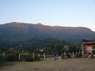
Igatpuri is a town and a Hill Station municipal council in Nashik District in the Indian state of Maharashtra. It is located in the Western Ghats. Igatpuri railway station lies in Nashik District between Mumbai and Nashik Road on the Central Railway. Igatpuri is known for Vipassana International Academy, where ancient technique of meditation is taught called Vipassana. The place is one of the best places to visit in Maharashtra in monsoon. It is a hill station on busy Mumbai-Agra NH-3 only 45 km from Nashik and 130 km from Mumbai.
Nashik division is one of the six divisions of India's Maharashtra state and is also known as North Maharashtra. The historic Khandesh region covers the northern part of the division, in the valley of the Tapti River. Nashik Division is bound by Konkan Division and the state of Gujarat to the west, Madhya Pradesh state to the north, Amravati Division and Marathwada to the east, and Pune Division to the south. The city of Nashik is the largest city of this division.

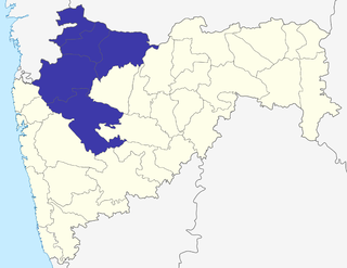
Nashik district, also known as Nasik district, is a district in Maharashtra, India. The city of Nashik is the administrative headquarters of the district. Nashik is well known for the production of wine. Nashik is also known as Mini Maharashtra, because the climate and soil conditions of Surgana, Peth, Igatpuri resembles with Konkan. Niphad, Sinnar, Dindori, Baglan blocks are like Western Maharashtra and Yeola, Nandgaon, Chandwad blocks are like Vidarbha Region. Nashik, Malegaon, Manmad, Igatpuri are some of the big cities situated in the Nashik District.

Bhandardara is a holiday resort village near Igatpuri, in the western ghats of India. The village is located in the Tehsil Akole Ahmednagar district of the state of Maharashtra, about 185 kilometers (115 mi) from Mumbai.

Mangi-Tungi is a prominent twin-pinnacled peak with plateau in between, located near Tahrabad about 125 km from Nashik, Maharashtra, India. Mangi, 4,343 ft (1,324 m) high above sea level, is the western pinnacle and Tungi, 4,366 ft (1,331 m) high, the eastern. Mangi-Tungi is only 100 km away from Dhule, a well known city and district place in North Maharashtra (Khandesh).

Maharashtra attracts tourists from different states and foreign countries. It was the second most visited Indian state by foreigners and fourth most visited state by domestic tourists in the country in 2014. Aurangabad is the tourism capital of Maharashtra. Major urban cities include : Mumbai, Pune, Nashik, Aurangabad and Nagpur.
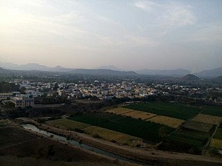
Baglan is a taluka (tehsil) in Nashik District in the Indian state of Maharashtra. Sometimes Baglan Taluka is unofficially referred to as Satana, because of that city's dominance within the taluka.
Dhodap, is one of the hill forts in Maharashtra state in India. Situated in Chandwad taluka in the Nashik district. the fort is 4829 ft above sea level. It is the site of the second highest fort in the Sahyadri mountains after Salher. Dhodap hill is the third highest hill peak in Maharashtra after Kalsubai and Salher and the 29th highest peak in Western Ghats.

Brahmagiri is a mountain range in the Western Ghats of Maharashtra. It is situated in Nashik District in the Indian state of Maharashtra. Trimbakeshwar Shiva Temple is located near this place. The origin of the sacred Godavari river is near Trimbak. It flows for 1,465 kilometres (910 mi), first eastwards across the Deccan Plateau then turns southeast, entering the West Godavari district and East Godavari district of Andhra Pradesh, until it splits into two watercourses that widen into a large river delta and flow into the Bay of Bengal.
Abhona is a village in Kalwan tehsil of Nashik district in the Indian state of Maharashtra. It belongs to the North Maharashtra region.

Satmala is a mountain range which runs across Nashik District, Maharashtra. They are an integral part of the Sahyadris range within Nashik. These peaks are visible from a greater part of the district and form prominent landmarks. The highest of them is Dhodap. Dhodap hill is the third highest hill peak in Maharashtra after Kalsubai and Salher and 29th highest peak in the Western Ghats. At the eastern side of this range lies the Chanvad range. There is a range with the same name Satmala in Telangana.
Nashik District, a district in Maharashtra, India, is noted for the mountains and hills occupying the north and north-east of its territory.These hill ranges are eastward spurs of the Western Ghats and form prominent landmarks in the district, some noted for the shrines they harbor while others for the trekking adventures which can be undertaken while ascending the peaks. Broadly categorized, the hills can be segregated into 3 noteworthy ranges:
Trimbakeshwar Range is a mountain range in the Western Ghats of Maharashtra entirely situated in Nashik District. The range lies 30 km southwest to the district headquarters Nashik. The saddle shaped depression of the Brahmagiri mountain protects Trimbak, a town considered holy by Hindus Devotees throng to this town to pay visit to the sacred Trimbakeshwar Shiva Temple. The northern face of the range is the birthplace of India's 2nd longest river Godavari.The southern face of these hills are covered with dense forests and thus form a catchment area for the Upper Vaitarna Reservoir, the most important and reliable source of potable water supply to the metropolitan city of Mumbai. Trimbakeshwar range also contain the Anjaneri hills though a minority of authors consider the latter to be a distinct range and often prefer to use the synonym Trimbak-Anjaneri to avoid disambiguation.

The Statue of Ahimsa is located at Mangi-Tungi, in Nashik, in the Indian state of Maharashtra. It is the tallest Jain statue in the world. The statue depicts the first Jain Tirthankara, Rishabhanatha. The statue is 108 feet tall – 121 feet including pedestal. The statue has been carved out of the Mangi-Tungi hills, which are considered to be sacred by the Jains. This statue holds the Guinness world record for the tallest Jain Idol. The certificate was awarded to Ganini Gyanmati Mataji, Chandnamati Mataji and Swami Ravindrakirtiji on 6 March 2016.

Mora fort is located in the Baglan area of Nashik district. There are two main hill ranges in Baglan area, the Selbari range is south of the Dolbari hill range. These two ranges run parallel to each other in east-west direction. Moragad is located on Selbari hill range. All these forts were maintained to keep watch on the Burhanpur-Surat ancient commercial road. The road passes between the two hill ranges. Mora fort is a small fort, close to Mulher fort.

The culture of the city of Nashik, in northwestern Maharashtra, is centred around Hindu customs and festivals, and the Jain Statue of Ahimsa.

Hargad fort is located in the Baglan area of Nashik district. There are two main hill ranges in Baglan area, the Selbari range is south of the Dolbari hill range. These two ranges run parallel to each other in east-west direction. Hargad is located on Selbari hill range.All these forts were maintained to keep watch on the Burhanpur-Surat ancient commercial road. The road passes between the two hill ranges.Hargad fort is a small fort, close to Mulher fort. These are key forts situated between fertile lands of Khandesh and port city of Surat.
Bhupatgad Fort(Marathi: बितनगड, बिटका) is a fort in Nashik district in the Igatpuri taluka in Maharashtra state of India.


