
Kurla is a suburb of East Mumbai, India. It is the headquarters of the Kurla taluka of Mumbai Suburban district. The neighbourhood is named after the eponymous East Indian village that it grew out of. It falls under Zone 5, Ward 'L' of the Bombay Municipal Corporation. Its railway station, spelt as Coorla until 1890, is one of the busiest on the Mumbai suburban railway on the central and harbour railway lines of Mumbai as is the Lokmanya Tilak Terminus (LTT) for out-station passenger/express trains.

Santacruz or Santa Cruz is a suburb of Mumbai. The Santacruz railway station on the Mumbai Suburban Railway, the domestic terminal (T1) of the Chhatrapati Shivaji Maharaj International Airport, and one campus of the University of Mumbai, are all located in Santacruz (East).

The Mumbai Metro is a rapid transit (MRT) system serving the city of Mumbai and the wider Mumbai Metropolitan Region in Maharashtra, India.

Sanjay Gandhi National Park (SGNP), is an 87 km2 (34 sq mi) protected area in Mumbai, Maharashtra. It was established in 1969 with its headquarters situated at Borivali.

Dharavi is a residential area in Mumbai, Maharashtra, India. It has often been considered to be one of the world's largest slums. Dharavi has an area of just over 2.39 square kilometres and a population of about 1,000,000. With a population density of over 277,136/km2 (717,780/sq mi), Dharavi is one of the most densely populated areas in the world.

Aarey Milk Colony is within Sanjay Gandhi National Park (SGNP). It is classified as mixed moist deciduous type forest. It acts as a buffer between SGNP and the city, being one of the few green spaces left in Mumbai. On 3 September 2020, the Maharashtra government declared one fifth of the Aarey Colony, an area of approximately 600 acres, as a reserved forest.
The 2005 Maharashtra floods impacted many parts of the Indian state of Maharashtra including large areas of the metropolis Mumbai, a city located on the coast of the Arabian Sea, on the Western coast of India, in which approximately 1,094 people died. It occurred just one month after the June 2005 Gujarat floods. The term 26 July, is used to refer to the day when the city of Mumbai came to a standstill due to flooding.

Mumbai Suburban district is the second most populous district of Maharashtra in the Konkan Division. With its administrative headquarters in Bandra, the district consists of three subdivisions or tehsils (townships): Kurla, Andheri, and Borivali. The district along with Mumbai City district and other suburban localities make up Greater Mumbai. The district occupies an area of 446 km2.

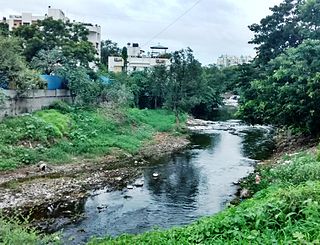
Oshiwara River is a river in Mumbai, India. It begins in the Aarey Milk Colony, cuts through the Goregaon hills, across the Aarey Milk Colony before emptying into the Malad Creek. On the way it is joined by another creek near Swami Vivekanand Road, before picking up industrial effluents and sewage while crossing the Oshiwara industrial estates and slums of Andheri. Most of the call centres in Malad have been built on reclaimed ground at the mouth of the river.
Ramnadi is a river in Pune District and is a tributary of Mula. It originates in the Sahyadris near Kathpewadi, north-west of Pune city. The river flows through the Bhugaon, Bhukum, Bavdhan, Pashan, Baner and Aundh areas of Pune city. It is defined as a brook by the Pune Municipal Corporation (PMC).
Mankhurd Shivaji Nagar Assembly constituency is one of the 288 Vidhan Sabha constituencies of Maharashtra state in western India.

The Nag River is a river flowing through the city of Nagpur in Maharashtra, India. It is known for providing the etymology for the name Nagpur.

Dahisar is a railway station on the Western line of the Mumbai Suburban Railway network. Dahisar station is the last station within the Brihanmumbai Municipal Corporation limits. The area around the station has heavy traffic and is congested.
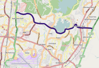
The Jogeshwari–Vikhroli Link Road (JVLR), is a 10.6-kilometre-long (6.6 mi) 6-lane road with a central median in Mumbai which connects the Western Express Highway and Eastern Express Highway providing speedier access from Jogeshwari in the Western Suburbs to Vikhroli in the Eastern Suburbs. It was opened to traffic in 1994, and widened from two to six lanes in 2012 at a cost of ₹221.45 crore. The under-construction Line 6 of the Mumbai Metro is being constructed on this link road.
Kherwadi is a middle class, developing neighborhood, situated on the eastern side of Bandra railway station, Mumbai. Its name is derived from the first chief minister of Bombay State, B. G. Kher. It is surrounded by the CBD of BKC to the east, Mahim to the south, Khar to the north and S.V. Road to the west. It is well connected to all the parts of Mumbai, Navi Mumbai and Thane. Western Expressway passes through Kherwadi junction, a signal intersection situated in Kherwadi.
![<span class="mw-page-title-main">Vanashakti</span> Non-profit environmental organization [VANASHAKTI]](https://upload.wikimedia.org/wikipedia/en/0/0a/Vanashakti_Logo.jpg)
Vanashakti is a non-profit environmental NGO based in Mumbai, Maharashtra. It was formed in 2006, by Meenakshi Menon, Namita Roy Ghose, and Peter Armand Menon. Vanashakti aims to conserve the forests, wetlands, wildlife corridors, habitats, through education and litigation to achieve its objectives of creating awareness about environmental topics, protecting and reviving rivers and preventing opencast mining in areas that are well-endowed with biodiversity. It also directs its efforts in involving local forest-dwelling communities to protect the biodiversity of the region and provides sustainable livelihood options for forest dependent and coastal communities. Vanashakti's thrust areas are forest, mangrove and wetland protection, environmental education for both urban and rural schools, livelihoods for forest based communities and scientific investigation into local environmental degradation.
Line 2 (Yellow Line) of the Mumbai Metro is a rapid transit metro line in the city of Mumbai, Maharashtra, India. The line connects Dahisar in the northwest with Mandale in Mankhurd via Andheri, BKC and Chembur in the east. Phase One of Line 2A was partially opened on 2 April 2022 from Dahisar East to Dahanukarwadi.

Red Line 9 (extension) of the Mumbai Metro is part of the metro system for the city of Mumbai, India. Metro Line 9 is an extension of the Red Line from Andheri to CSMIA and Dahisar to Mira Road. This line will be unique from the other metro lines because it will run on a double-decker bridge. There will be a flyover on the first deck and the metro will run on the second deck. The flyover will start near the proposed Shivaji Chowk metro station and will end in Bhayander (West) via Mira Bhayander Road. It shall provide interconnectivity among the Western Express Highway, the Western Line, and the Mumbai Metro.
Mumbai Climate Action Plan, a state-government initiative was established in 2021 to tackle and solve the increasing challenges of climate change. This Planning process was unveiled by the former Environment Minister of Maharashtra, Aaditya Thackeray in September 2021 after Mumbai joined the C40 Cities Network in December 2020. This climate action plan is being drafted by the Brihanmumbai Municipal Corporation (MCGM) in assistance with World Resources Institute (WRI), a knowledge partner. This plan will serve as a 30-year roadmap and systematic framework to guide the city, Mumbai, and look climate resilience with mitigation and adaptation strategies through low-carbon, resilient, and inclusive development pathways. Being India's first climate action plan, it is aiming to set net-zero greenhouse gas emissions and green targets for 2050, twenty years before the target set by the Central Government of India at the Glasgow COP summit in 2021. The six key action areas and strategies laid out in this plan are: Sustainable Waste Management, Urban greening & biodiversity, Urban flooding & water resource management, Energy & buildings, Air quality and Sustainable Mobility.

