South Mumbai

Last updated

South Mumbai
South Bombay
Old Mumbai / Mumbai City District
Precinct of Mumbai
SBML9878-140422-BackBay skyline.jpg
View of Southern Mumbai Skyline (Worli)
South Mumbai as at 2013.png
South Mumbai precinct highlighted in yellow
Mumbai area locator map.svg
Red pog.svg
South Mumbai
South Mumbai
India Maharashtra location map.svg
Red pog.svg
South Mumbai
South Mumbai (Maharashtra)
India location map 3.png
Red pog.svg
South Mumbai
South Mumbai (India)
Coordinates(Malabar Hill): 18°57′00″N72°47′42″E / 18.95°N 72.795°E / 18.95; 72.795
CountryFlag of India.svg  India
State Flag of Maharashtra.svg Maharashtra
District MCGM Seal.jpg Mumbai City
City Mumbai
Wards A, B, C, D, E,
FS, FN, GS, GN
Government
  Body BMC
Area
  Total67.7 km2 (26.1 sq mi)
Population
 (2011)
  Total3,145,966
  Density46,000/km2 (120,000/sq mi)
Demonym(s) Mumbaikar, Soboite
Time zone UTC+5:30 (IST)
Historical population
YearPop.±%
1971 3,070,380    
1981 3,285,040+7.0%
1991 3,174,910−3.4%
2001 3,326,840+4.8%
2011 (est) 3,145,966−5.4%
Data is based on Government of India Census.
Source: MMRDA [1]
Aerial view of Malabar Hill to the left and Girgaon Chowpatty to a little right. Malabar Hill (aerial view).jpg
Aerial view of Malabar Hill to the left and Girgaon Chowpatty to a little right.
Settlements of South Mumbai South Mumbai.jpg
Settlements of South Mumbai

South Mumbai, colloquially SoBo from South Bombay in Indian English, [2] [3] administratively the Mumbai City District, is the city centre and the southernmost precinct of Greater Bombay. It extends from Colaba to Mahim and Sion neighbourhoods, and comprises the city's main business localities, making it the wealthiest urban precinct in India. Property prices in South Mumbai are by far the highest in India and among the highest in the world.[ citation needed ]

Contents

Taj Mahal Hotel, Gateway of India, Victoria Terminus, Ballard Estate, and the Bombay Harbour are some of the most iconic landmarks of South Bombay. Billionaire Mukesh Ambani's $1.5 billion home Antilia is located here and is now a part of the iconic skyline. Most residents of South Mumbai belong to old money business, law, trade and fashion families. Geographically, South Mumbai lies at the southern most extent of Salsette Island. Most city residents use the term to refer to the stretch extending from Colaba to Mahim and Sion as South Mumbai. The area is delimited on the east by Mumbai harbour and on the west by the Arabian Sea.

South Mumbai is also home to many educational institutions; namely Cathedral and John Connon School, St. Anne's High School, Fort, JB Petit, Campion, Bombay International School, St. Mary's School, Mumbai, etc; exclusive sports clubs: CCI, The Willingdon Sports Club, as well as the Bombay Gymkhana; and hospitals such as Breach Candy Hospital, Bombay Hospital, Jaslok Hospital, and Hurkisondas Hospital.

Significance

South Mumbai hosts the Reserve Bank of India, Bombay Stock Exchange and one of the oldest YMCA buildings. Its primary business districts are the Fort, Nariman Point, Ballard Estate and more recently Lower Parel, Mumbai Central. Many leading Indian and multi-national companies are headquartered here. Chhatrapati Shivaji Maharaj Terminus (CSMT) and Churchgate serve as headquarters and starting point for country's Central Railway and Western Railway lines respectively.

The headquarters of the Brihanmumbai Municipal Corporation, the governing civic body of Greater Mumbai is located in South Mumbai. The Bombay High Court is also in South Mumbai.

The terrorist attacks of 2008 included many prominent South Mumbai locations including Taj Mahal Palace Hotel in Colaba, Leopold Cafe and Chhatrapati Shivaji Maharaj Terminus. [4]

The area houses a significant proportion of prime upmarket residential neighbourhoods of Mumbai including: Pedder Road, Nepean Sea Road, Kemps Corner, Altamount Road, Carmichael Road, Breach Candy and Walkeshwar Road, forming a sort of golden quadrilateral and includes some of the most expensive residential areas in the world, such as the Hanging Gardens, Kemps Corner, Cuffe Parade and Malabar Hill.

South Mumbai is home to two UNESCO World Heritage Sites: Chhatrapati Shivaji Maharaj Terminus and the city's distinctive ensemble of Victorian and Art Deco buildings. South Mumbai boasts a large number of Art Deco buildings, second only to Miami. [5] South Mumbai's architecture also comprises historical monuments from the colonial era which attract tourists throughout the year.

South Mumbai has many educational institutions such as Jamnalal Bajaj Institute of Management Studies, St. Xavier's College, Government Law College, Jai Hind College, Wilson College, Grant Medical College, Sydenham Institute of Management Studies, Research and Entrepreneurship Education, among others.

Many distinctive sporting clubs have been an integral part of South Mumbai landscape like the Willingdon Sports Club, the Turf Club at Mahalaxmi Racecourse, the Bombay Gymkhana, the Breach Candy Club, the N.S.C.I., and the Malabar Hill Club (Formerly W.I.A.A. Club). The Cricket Club of India (CCI) and Mumbai Cricket Association (MCA) are located at Mumbai's two cricket stadiums, namely Brabourne Stadium and Wankhede Stadium respectively.

Although land reclamation has allowed the southernmost tip of the district to double in size since the 1970s, the business districts face an acute shortage of real estate. As a result, the real-estate prices are among the top ten worldwide. As a ratio to average per capita income, real-estate prices in the business districts remain the most expensive in the world. [6]

South Mumbai is also home to such sporting grounds as Brabourne Stadium, Wankhede Stadium, Shivaji Park, Azad Maidan, Oval Maidan, and Cooperage Ground.

Mumbai's most popular beach, Girgaon Chowpatty is located at the beginning of a 3.6 km esplanade known as the Marine Drive which is a popular hangout spot among the citizens. Another popular esplanade in South Mumbai is the Worli Seaface.

South Mumbai has popular art galleries and museums like Chhatrapati Shivaji Maharaj Vastu Sangrahalaya, Jehangir Art Gallery, Nehru Centre Art Gallery. Sobo Films, an independent film producer, has been named after the area but is itself based in Andheri in the west. [7]

South Mumbai has become less congested with the creation of the Bandra Worli Sea Link. Auto rickshaws are strictly banned here. This facilitates quicker transport between people residing in the suburbs and the corporate offices in South Mumbai. Traffic is a major concern in most parts.

Division

The city of Mumbai lies on Salsette Island. Administratively it has two official divisions: Mumbai City district and Mumbai Suburban district. Mumbai City district consists of the Southern part of Salsette Island - the area is called South Mumbai. Mumbai Suburban district consists the Western, Eastern, Central and Northern parts of the city. The northernmost portion of the island - outside Mumbai city limits - lies in Thane district.

Old Bombay

Bombay in 1909 Bombay 1909.jpg
Bombay in 1909

Old Bombay was used to refer to the area which was formed by the merging of the seven original islands of Mumbai, India. The term was used from the 19th century until the 1980s and is now considered archaic, however still widely used.

See also

Notes

Related Research Articles

<span class="mw-page-title-main">Mumbai</span> Capital of Maharashtra, India

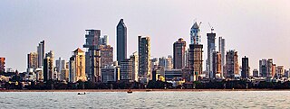
Mumbai is the capital city of the Indian state of Maharashtra. Mumbai is the financial capital and the most populous city of India with an estimated population of 12.5 million (1.25 crore). Mumbai is the centre of the Mumbai Metropolitan Region, the sixth-most populous metropolitan area in the world with a population of over 23 million living within the Mumbai Metropolitan Region. Mumbai lies on the Konkan coast on the west coast of India and has a deep natural harbour. In 2008, Mumbai was named an alpha world city. Mumbai has the highest number of billionaires out of any city in India as well as in Asia.

<span class="mw-page-title-main">Chhatrapati Shivaji Terminus</span> Historic terminal train station in Mumbai, India

Chhatrapati Shivaji Terminus (officially Chhatrapati Shivaji Maharaj Terminus since 2017, formerly Victoria Terminus (VT), Bombay station code: CSMT (mainline)/ST (suburban)), is a historic railway terminus and UNESCO World Heritage Site in Mumbai, Maharashtra, India.

<span class="mw-page-title-main">Mahim</span> Neighbourhood in Mumbai City, Maharashtra, India

Mahim (Marathi: माहिम) is a neighbourhood in Mumbai, Maharashtra, India. The Mahim Junction railway station on the Western Railway and Harbour Railway of the Mumbai Suburban Railway network is the last station of the city, as neighboring Bandra comes in Mumbai Suburb. Mahim is an ethnically and religiously diverse town and has a Hindu temple, church, mosque and Parsi fire-temple existing within a few meters of each other. The town has a large Rich and Upper Middle class Marathi population.

<span class="mw-page-title-main">Colaba</span> Neighbourhood in Mumbai City, Maharashtra, India

Colaba is a part of the city of Mumbai, India. It is one of the four peninsulas of Mumbai while the other three are Worli, Bandra and Malabar Hill. During Portuguese rule in the 16th century, the island was known as Kolbhat. After the British took over the island in the late 17th century, it was known as Kolio.

<span class="mw-page-title-main">Churchgate</span> Neighbourhood in Mumbai City, Maharashtra, India

Churchgate is an area in the southern part of Mumbai, close to the Arabian Sea. The area is known for its unique architecture consisting of art deco style residential buildings, access to sporting venues, and the business district of Nariman Point.

<span class="mw-page-title-main">Seven Islands of Bombay</span> 16th century Portuguese colony

The Seven Islands of Bombay were 16th-century Portuguese colonial possessions lying off the Konkan region by the mid-west coast of India.

<span class="mw-page-title-main">Geography of Mumbai</span> Overview of Mumbais geography

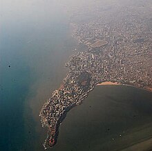
Mumbai (Bombay) is India's most populous city with a population of 20 Million. It is located on Salsette Island off the coast of Maharashtra. The original Seven Islands of Bombay were merged by the British in the 18th century, to form one large island.

<span class="mw-page-title-main">Mumbai culture</span>

A resident of Mumbai is called a Mumbaikar. People prefer to stay close to a railway station for easy access to the metropolis. Many city-dwellers lead a fast-paced life with very little time for other activities owing to a significant amount of time spent on daily commuting.

<span class="mw-page-title-main">Fort (Mumbai precinct)</span> Neighborhood in Mumbai City, Maharashtra, India

Fort is a business and art district in the city of Mumbai, Maharashtra, India. The area gets its name from the defensive fort, Fort George, built by the British East India Company around Bombay Castle.

<span class="mw-page-title-main">Fort Vasai</span> Fort in Vasai, Maharashtra, India

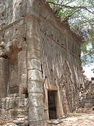
Fort Vasai is a ruined fort of the town of Vasai (Bassein), Konkan Division, Maharashtra, Indian Union. The structure was formally christened as the Fort of St Sebastian in the Indo-Portuguese era. The fort is a monument of national importance and is protected by the Archaeological Survey of India.

<span class="mw-page-title-main">Mahim Causeway</span>

The Mahim Causeway is a vital link road connecting Mumbai City district/South Mumbai with its Northern and Western Suburbs. The causeway links the neighbourhoods of Mahim to the south with Bandra to the north.

Colaba Causeway, officially known as Shahid Bhagat Singh Road, is a commercial street, and a major causeway or land link between Colaba and the Old Woman's Island in the city of Mumbai, India.

Indigenous tribals have inhabited Mumbai (Bombay) since the Stone Age. The Kolis and Aagri were the earliest known settlers of the islands. Between the 2nd century BCE and 10th century CE, the islands came under the control of successive indigenous dynasties: the Satavahanas, Abhiras, Vakatakas, Kalachuris, Konkan Mauryas, Chalukyas, Rashtrakutas, Silharas & Chollas.

<span class="mw-page-title-main">Shivaji Park Residential Zone</span> Neighbourhood in Mumbai City, Maharashtra, India

The Chatrapati Shivaji Maharaj Park Residential Zone is a precinct consisting of 187 residential buildings that were built as part of the Chatrapati Shivaji Maharaj Park scheme in Dadar, Mumbai. Most of the buildings in this residential locality were constructed in the early 1900s during British colonial rule in India, as a result of which many buildings here exhibit aspects of British architecture.

<span class="mw-page-title-main">History of Bombay under Portuguese rule (1534–1661)</span>

Bombay, also called Bom Bahia or Bom Baim in Indo-Portuguese creole, Mumbai in the local language; is the financial and commercial capital of India and one of the most populous cities in the world. It's also the cosmopolitan city centre of the Greater Bombay Metropolitan Area, and the cultural base of the Bollywood film industry. At the time of arrival of the Portuguese Armadas, Bombay was an archipelago of seven islands. Between the third century BCE and 1348, the islands came under the control of successive Hindu dynasties. The Delhi Sultanate had been ruling the area along with Chaul, New Bombay (Thana) & Damaon, with the administrative centre in Bassein (Vasai) since the raids of Malik Kafur in the Konkan region and across the Indian subcontinent. This territory in North Konkan along with the Bombay islands were later taken over by the Sultan of Guzerat from 1391 to 1534, when he had declared the end of the suzerainty to Delhi, after the Timurid invasion of it. Growing apprehensive of the power of the Moghal emperor Humayun, Sultan Bahadur Shah of Gujarat was obliged to sign the Treaty of Bassein on 23 December 1534; according to which, the seven islands of Bombay, Fort San Sebastian of Bassein in strategic town of Bassein (Vasai), and its dependencies were offered to the Portuguese East Indies. The places were only later officially surrendered on 25 October 1535, by the Sultan of Guzerat.

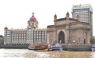
The architecture of Mumbai blends Gothic, Victorian, Art Deco, Indo-Saracenic & Contemporary architectural styles. Many buildings, structures and historical monuments remain from the colonial era. Mumbai, after Miami, has the second largest number of Art Deco buildings in the world.

<span class="mw-page-title-main">Western Suburbs (Mumbai)</span> Precinct of Greater Mumbai in Maharashtra, India

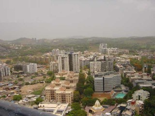
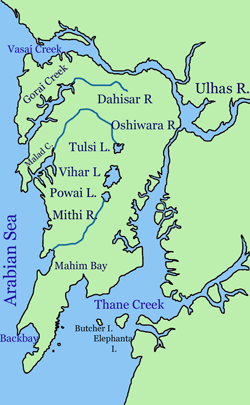
The Western Suburbs is the western precinct of the city of Mumbai, India. The Western Suburbs consist of Andheri, Bandra, Bhayander, Borivali, Dahisar, Goregaon, Jogeshwari, Juhu, Kandivali, Khar, Malad, Mira Road, Santacruz and Vile Parle. Geographically, the Western Suburbs lie at the western part of Salsette Island, is a continuous urban sprawl spanning the areas from Bandra to Bhayander, which is separated by the Vasai Creek from Vasai-Virar city and Mithi River from Mumbai city district.

Kherwadi is a middle class, developing neighborhood, situated on the eastern side of Bandra railway station, Mumbai. Its name is derived from the first chief minister of Bombay State, B. G. Kher. It is surrounded by the CBD of BKC to the east, Mahim to the south, Khar to the north and S.V. Road to the west. It is well connected to all the parts of Mumbai, Navi Mumbai and Thane. Western Expressway passes through Kherwadi junction, a signal intersection situated in Kherwadi.

<span class="mw-page-title-main">Heritage structures in Mumbai</span>

Many heritage structures are found in Mumbai, India.

References

  1. Population and Employment profile of Mumbai Metropolitan Region, p. 7
  2. Eyewitness, D. K. (3 October 2019). DK Eyewitness Top 10 Mumbai. Dorling Kindersley Limited. ISBN   978-0-241-43046-0.
  3. "Malavika's Mumbaistan: Mumbai's North-South Divide". Hindustan Times. 2 July 2021. Retrieved 29 November 2021.
  4. "Mumbai Terrorist Attacks Of 2008 | Events, Death Toll, & Facts | Britannica". www.britannica.com. Retrieved 16 November 2022.
  5. Chandrashekhar, Vaishnavi (21 October 2019). "Discovering Mumbai's Art Deco Treasures". The New York Times. ISSN   0362-4331 . Retrieved 16 November 2022.
  6. Sheng, Ellen. "The Five Most Expensive Cities In The World". Forbes. Retrieved 16 November 2022.
  7. Sobo Films, sobofilms.com. Accessed 1 March 2024.

18°58′N72°49′E / 18.96°N 72.82°E / 18.96; 72.82