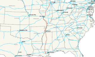
Interstate 55 (I-55) is a major Interstate Highway in the central United States. As with most interstates that end in a five, it is a major cross-country, north-south route, connecting the Gulf of Mexico to the Great Lakes. The highway travels from LaPlace, Louisiana, at I-10 to Chicago at U.S. Route 41, at McCormick Place. The major cities that I-55 connects to are New Orleans, Jackson, Mississippi, Memphis, St. Louis, and Chicago.
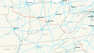
Interstate 74 (I-74) is an Interstate Highway in the midwestern and southeastern United States. Its western end is at an interchange with Interstate 80 in Davenport, Iowa ; the eastern end of its Midwest segment is at an interchange with Interstate 75 in Cincinnati, Ohio. The major cities that I-74 connects to includes Davenport, Iowa; Peoria, Illinois; Champaign, Illinois; Indianapolis, Indiana; and Cincinnati, Ohio. I-74 also exists as several disconnected sections of highways in North Carolina.

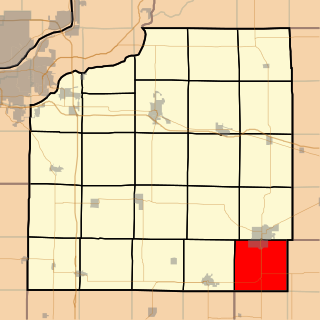
Stark County is a county located in the U.S. state of Illinois. According to the 2010 census, it had a population of 5,994. Its county seat is Toulon.

U.S. Route 14, an east–west route, is one of the original United States highways of 1926. It currently has a length of 1,398 miles (2,250 km), but it had a peak length of 1,429 miles (2,300 km). For much of its length, it runs roughly parallel to Interstate 90.

U.S. Route 40 or U.S. Highway 40 (US 40), also known as the Main Street of America, is a major east–west United States Highway traveling across the United States from the Mountain States to the Mid-Atlantic States. As with most routes whose numbers end in a zero, US 40 once traversed the entire United States. It is one of the first U.S. Highways created in 1926 and its original termini were in San Francisco, California and Atlantic City, New Jersey. In the western United States, US 40 was functionally replaced by Interstate 80 (I-80), resulting in the route being truncated multiple times. US 40 currently ends at a junction with I-80 in Silver Summit, Utah, just outside Salt Lake City.

U.S. Route 45 is a major north-south United States highway and a border-to-border route, from Lake Superior to the Gulf of Mexico. A sign at the highway's northern terminus notes the total distance as 1,297 miles (2,087 km).

U.S. Route 67 is a major north–south U.S. highway which extends 1,560-mile-long (2,511 km) in the Central United States. The southern terminus of the route is at the United States-Mexico border in Presidio, Texas, where it continues south as Mexican Federal Highway 16 upon crossing the Rio Grande. The northern terminus is at U.S. Route 52 in Sabula, Iowa.
U.S. Route 60 or U.S. Highway 60 (US 60) is a major east–west United States highway, traveling 2,655 mi (4,273 km) from southwestern Arizona to the Atlantic coast in Virginia. The highway's eastern terminus is in Virginia Beach, Virginia, where it is known as Pacific Avenue, in the city's Oceanfront resort district at the intersection of 5th Street and Winston-Salem Avenue. Its original western terminus was in Springfield, Missouri; it was then extended to Los Angeles, California; but in 1964 it was truncated to end southwest of Brenda, Arizona at an interchange with Interstate 10 (I-10) after the US 60 highway designation was removed from California. Some US 60 signs can be seen at this interchange about 5 mi (8.0 km) southwest of Brenda. I-10 replaced US 60 from Beaumont, California to Arizona, and California State Route 60 (SR 60) replaced US 60 from Los Angeles to Beaumont.

U.S. Route 34 (US 34) is an east–west United States highway that runs for 1,122 miles (1,806 km) from north-central Colorado to the western suburbs of Chicago. Through Rocky Mountain National Park it is known as the Trail Ridge Road where it reaches elevation 12,183 feet (3,713 m), making it the highest paved through highway in the United States. The highway's western terminus is Granby, Colorado at US 40. Its eastern terminus is in Berwyn, Illinois at Illinois Route 43 and Historic US 66.

U.S. Route 36 (US 36) is an east–west United States highway that travels approximately 1,414 miles (2,276 km) from Rocky Mountain National Park, Colorado to Uhrichsville, Ohio. The highway's western terminus is at Deer Ridge Junction, an intersection in Rocky Mountain National Park, Colorado, where it meets US 34. Its eastern terminus is at US 250 in Uhrichsville, Ohio.

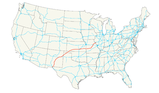
U.S. Route 51 or U.S. Highway 51 is a major south-north United States highway that extends 1,277 miles (2,055 km) from the western suburbs of New Orleans, Louisiana, to within 150 feet (46 m) of the Wisconsin–Michigan state line. As most of the United States Numbered Highways ending with "1", it is a cross-country north-south route extending from the Gulf Coast region to the Great Lakes region. Much of the highway in northern Illinois and southern Wisconsin runs parallel to or is cosigned with Interstate 39 (I-39) and much of the route in several states also parallels the Illinois Central Railroad. From LaPlace, Louisiana, Mississippi, to Memphis, Tennessee, much of that portion of US 51 runs largely parallel or is concurrent with Interstate 55 (I-55). The highway's northern terminus is between Hurley, Wisconsin, and Ironwood, Michigan, where it ends with a T interchange at US 2. Its southern terminus is in Laplace, Louisiana, ending at US 61. US 51 travels in the states of Louisiana, Mississippi, Tennessee, Kentucky, Illinois, and Wisconsin.
U.S. Route 54 is an east–west United States highway that runs northeast–southwest for 1,197 miles (2,115 km) from Griggsville, Illinois to El Paso, Texas. It enters and leaves Texas twice. The Union Pacific Railroad's Tucumcari Line runs parallel to US-54 from El Paso to Pratt, Kansas, which comprises about two-thirds of the route.
U.S. Route 319 is a spur of U.S. Route 19. It runs for 303 miles (488 km) from the foot of the John Gorrie Memorial Bridge across from downtown Apalachicola, Florida to US 1/SR 4 in Wadley, Georgia, through the Panhandle of Florida and the southern portion of Georgia.
U.S. Highway 136 is a spur of U.S. Highway 36. It runs from Edison, Nebraska, at U.S. Highway 6 and U.S. Highway 34 to the Interstate 74/Interstate 465 interchange in Speedway, Indiana. This is a distance of 804 miles (1,294 km). US 136 never meets its parent, US 36. However, it does come within 2 miles of it at its interchange with I-465/I-74 at its eastern terminus.

U.S. Route 460 (US 460) is a spur of U.S. Route 60. It currently runs for 655 miles (1,054 km) from Norfolk, Virginia, at its parent route U.S. Route 60 at Ocean View to Frankfort, Kentucky, at its parent route once again. It passes through the states of Virginia, West Virginia, and to Frankfort, Kentucky, the state capital. It goes through the cities of Norfolk, Portsmouth, Suffolk, Petersburg, Farmville, Lynchburg, Roanoke, Blacksburg, Tazewell, and Grundy, in Virginia; Princeton and Bluefield in West Virginia; and Pikeville, and Frankfort, Kentucky.
Illinois Route 72 is an east–west state road in northern Illinois. It runs from the intersection with Illinois Route 73 north of Lanark east to Illinois Route 43 in Chicago. This is a distance of 110.71 miles (178.2 km).
Illinois Route 125 (IL-125) is a major 37.10 miles (59.71 km) highway in the central portion of the U.S. state of Illinois. Illinois 125 runs east from the concurrent U.S. Route 67 and Illinois Route 100 near Beardstown to Illinois Route 97 in Farmingdale, west of Springfield.
U.S. Route 20 in the U.S. state of Illinois is a major arterial highway that runs from the Iowa state line at East Dubuque at the northwestern tip of Illinois, to the Indiana state line at Chicago south of the Chicago Skyway, a distance of 233.93 miles (376.47 km). For its entire length, US 20 is designated as the General Ulysses S. Grant Highway, often abbreviated the U.S. Grant Memorial Highway. However, this name is only commonly used west of Elgin. US 20 bypasses the city of Elgin on a freeway known as the Elgin Bypass or Dr. Martin Luther King Jr. Memorial Highway. From Elgin to Melrose Park, US 20 follows Lake Street. It then follows Mannheim Road, and further south La Grange Road. US 20 also follows 95th Street as it turns east through Chicago's southwestern suburbs. It ultimately leaves Illinois on Indianapolis Boulevard.
Wethersfield Township is one of twenty-four townships in Henry County, Illinois, USA. As of the 2010 census, its population was 3,935 and it contained 1,827 housing units.
Several special routes of U.S. Route 30 exist. In order from west to east they are as follows.


