Pacific Northwest National Laboratory (PNNL) is one of the United States Department of Energy national laboratories, managed by the Department of Energy's (DOE) Office of Science. The main campus of the laboratory is in Richland, Washington.
A GIS file format is a standard for encoding geographical information into a computer file, as a specialized type of file format for use in geographic information systems (GIS) and other geospatial applications. Since the 1970s, dozens of formats have been created based on various data models for various purposes. They have been created by government mapping agencies, GIS software vendors, standards bodies such as the Open Geospatial Consortium, informal user communities, and even individual developers.

Geomatics is defined in the ISO/TC 211 series of standards as the "discipline concerned with the collection, distribution, storage, analysis, processing, presentation of geographic data or geographic information". Under another definition, it consists of products, services and tools involved in the collection, integration and management of geographic (geospatial) data. Surveying engineering was the widely used name for geomatic(s) engineering in the past. Geomatics was placed by the UNESCO Encyclopedia of Life Support Systems under the branch of technical geography.

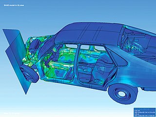
Scientific visualization is an interdisciplinary branch of science concerned with the visualization of scientific phenomena. It is also considered a subset of computer graphics, a branch of computer science. The purpose of scientific visualization is to graphically illustrate scientific data to enable scientists to understand, illustrate, and glean insight from their data. Research into how people read and misread various types of visualizations is helping to determine what types and features of visualizations are most understandable and effective in conveying information.

Visualization or visualisation is any technique for creating images, diagrams, or animations to communicate a message. Visualization through visual imagery has been an effective way to communicate both abstract and concrete ideas since the dawn of humanity. from history include cave paintings, Egyptian hieroglyphs, Greek geometry, and Leonardo da Vinci's revolutionary methods of technical drawing for engineering and scientific purposes.
An executive information system (EIS), also known as an executive support system (ESS), is a type of management support system that facilitates and supports senior executive information and decision-making needs. It provides easy access to internal and external information relevant to organizational goals. It is commonly considered a specialized form of decision support system (DSS).
In-Q-Tel (IQT), formerly Peleus and In-Q-It, is an American not-for-profit venture capital firm based in Arlington, Virginia. It invests in companies to keep the Central Intelligence Agency, and other intelligence agencies, equipped with the latest in information technology in support of United States intelligence capability. The name "In-Q-Tel" is an intentional reference to Q, the fictional inventor who supplies technology to James Bond.

Geoinformatics is a scientific field primarily within the domains of Computer Science and technical geography. It focuses on the programming of applications, spatial data structures, and the analysis of objects and space-time phenomena related to the surface and underneath of Earth and other celestial bodies. The field develops software and web services to model and analyse spatial data, serving the needs of geosciences and related scientific and engineering disciplines. The term is often used interchangeably with Geomatics, although the two have distinct focuses; Geomatics emphasizes acquiring spatial knowledge and leveraging information systems, not their development. At least one publication has claimed the discipline is pure computer science outside the realm of geography.
A GIS software program is a computer program to support the use of a geographic information system, providing the ability to create, store, manage, query, analyze, and visualize geographic data, that is, data representing phenomena for which location is important. The GIS software industry encompasses a broad range of commercial and open-source products that provide some or all of these capabilities within various information technology architectures.
MrSID is an acronym that stands for multiresolution seamless image database. It is a file format developed and patented by LizardTech for encoding of georeferenced raster graphics, such as orthophotos.

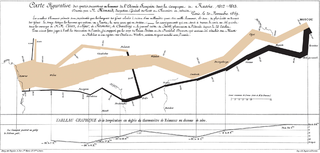
Data and information visualization is the practice of designing and creating easy-to-communicate and easy-to-understand graphic or visual representations of a large amount of complex quantitative and qualitative data and information with the help of static, dynamic or interactive visual items. Typically based on data and information collected from a certain domain of expertise, these visualizations are intended for a broader audience to help them visually explore and discover, quickly understand, interpret and gain important insights into otherwise difficult-to-identify structures, relationships, correlations, local and global patterns, trends, variations, constancy, clusters, outliers and unusual groupings within data. When intended for the general public to convey a concise version of known, specific information in a clear and engaging manner, it is typically called information graphics.

The Joint Global Change Research Institute (JGCRI) is a research institute established in 2001 through a collaboration between the University of Maryland, College Park, and the Pacific Northwest National Laboratory. The primary objective of the institute is to employ interdisciplinary approaches in climate change research.

The Environmental Molecular Sciences Laboratory is a Department of Energy, Office of Science facility at Pacific Northwest National Laboratory in Richland, Washington, United States.
NV5 Geospatial Solutions develops products for the visualization, analysis, and management of geospatial imagery and scientific data. The company develops products such as IDL, ENVI, Jagwire, and Helios which are used in a variety of industries including defense and intelligence, environmental, engineering, aerospace, medical imaging, federal and civil governments, precision agriculture and academia worldwide.
James Thomas was an American computer scientist in the field of visualization. He spent much of his career at the Pacific Northwest National Laboratory.
Geographic information systems (GIS) play a constantly evolving role in geospatial intelligence (GEOINT) and United States national security. These technologies allow a user to efficiently manage, analyze, and produce geospatial data, to combine GEOINT with other forms of intelligence collection, and to perform highly developed analysis and visual production of geospatial data. Therefore, GIS produces up-to-date and more reliable GEOINT to reduce uncertainty for a decisionmaker. Since GIS programs are Web-enabled, a user can constantly work with a decision maker to solve their GEOINT and national security related problems from anywhere in the world. There are many types of GIS software used in GEOINT and national security, such as Google Earth, ERDAS IMAGINE, GeoNetwork opensource, and Esri ArcGIS.

2d3 Sensing is an American motion imagery software company based in Irvine, California. It is a wholly owned subsidiary of UK-based OMG plc. Using structure from motion, the company’s suite of products can extract information from images or videos by recreating, manipulating, and enhancing imagery to visualize two-dimensional data into three dimensions. 2d3 follows a COTS business model and conforms to and influences emerging standards such as MISB and STANAG.
DAT/EM Systems International is an Alaska-based company that develops digital photogrammetric mapping applications to extract and edit 3D vector terrain and object features from stereo imagery and point clouds. DAT/EM Systems International develops solutions for the photogrammetry, engineering & GIS industries.


