Sultanpur, Uttar Pradesh

Last updated

Sultanpur
City
Sultanpur U.P Railway Station.JPG
Railway Station, Sultanpur
India Uttar Pradesh location map.svg
Red pog.svg
Sultanpur
India location map 3.png
Red pog.svg
Sultanpur
Coordinates: 26°15′30″N82°04′20″E / 26.25833°N 82.07222°E / 26.25833; 82.07222
CountryFlag of India.svg  India
State Uttar Pradesh
District Sultanpur
Government
  Body Government of Uttar Pradesh
Elevation
95 m (312 ft)
Population
 (2011) [1]
  Total107,640
Language
  Official Hindi [2]
  Additional official Urdu [2]
Time zone UTC+5:30 (IST)
PIN
228001
Vehicle registration UP-44
Website sultanpur.nic.in

Sultanpur is a city situated in the Indian state of Uttar Pradesh on the banks of the Gomti, which Hindus consider a holy river. The city is the administrative headquarters of Sultanpur district and is a part of Ayodhya division in Uttar Pradesh, India. [3] It is situated 135 kilometers east of state capital Lucknow.

Contents

History

According to legend, In the Sultanpur area beside the Gomti river it is said that Kush the son of Ram was born with badh(बाध) so it was the birthplace of Kusa, the son of Rama. [4] This was identified with the Kusapura mentioned by Xuanzang, who said that Gautama Buddha taught here for six months and that it had a stupa built at the time of Ashoka which was then in disrepair. [4]

The town was under Bhar rule until around 1200. It was said that when Muslims during the time of the Mamluk dynasty came to invade and loot in this area of Kusapura, the then Bhar rulers of Kusbhawanpur executed them and the horses were seized. [4] When it was heard to the Sultan Alauddin Khalji that this incident took place, he gathered an army and attacked them at once, on the opposite bank of the Gomti River from Kusbhawanpur. [4] Then Alauddin Khalji settled Muslims in the area of Mahmudpur located in Sultanpur. [4] The city of Kusbhawanpur was renamed after the Alauddin Khalji's title Sultan and a new city was founded on the site, called Sultanpur. [4]

Old Sultanpur was originally located on the left bank of the Gomti and is mentioned on several occasions by Muslim historians as the site of battles. [4] It was a prosperous town with several mohallas, or wards. [4] At some point, though, the British established a military station and cantonments on the opposite (right) bank of the Gomti, at a village then called Girghit, and this eventually took on the name Sultanpur instead while the old town declined. [4] The old town was described in 1839 as being in a state of disrepair, without commerce or industry, and with a population of just 1,500 people. [4] The only remains of the Bhar period were two brick wells on the south, "about a mile from the river", and a large mound or dih called Majhargaon in the middle of town, which was supposedly the remains of the old Bhar palace. [4] Atop Majhargaon was a fort built by the sultan, then partly ruined, and containing houses belonging to the faujdar and his followers. [4] Northwest of the fort was a mosque also built by the sultan, and there were also a couple of other mosques built by the Sayyid chaudhris of the pargana. [4] The town then had "many old brick dwelling houses and a few new ones". [4] Old Sultanpur was eventually razed to the ground by the British after the Indian Rebellion of 1857, in retaliation for the murder of two British officers in the town at the beginning of the uprising. [4]

As for the new Sultanpur, it was also called Chhaoni Sarkar by officials and Kampu, or "the camp", by locals. [4] It was built up on the site of the old cantonment, which was removed in 1861. [4] Sultanpur was made a municipality in June 1869, with a municipal committee; a municipal board was formed in September 1884. [4] In 1890 the Victoria Manzil was built for the first agricultural exhibition, and it served as the town hall and the meeting place for the municipal board under British rule. [4] At the turn of the 20th century, the town also had a police station and hospital, jail, poorhouse, leper asylum, and a dispensary which was rebuilt in 1895, at the same time as the Amethi female hospital was built in town, almost entirely funded by Raja Bhagwan Bakhsh Singh of Amethi. [4] The town also had three markets: Perkinsganj, Shawganj, and Partabganj, the last of which opened in 1895 and was named after Partab Bahadur Singh, the raja of Kurwar. [4]

Geography and climate

Sultanpur is the headquarters of the Sultanpur district, the north side of the district is bounded by Ayodhya district; the south side by Pratapgarh district; the west side by Barabanki and Amethi districts; and the east side by Azamgarh, Ambedkarnagar, and Jaunpur districts.

Sultanpur has an average elevation of 95 metres (312 ft). The geography of Sultanpur comprises plain lands, except for some regions around the Gomti River, which drains almost the whole city and district. The southern part of the city drains towards the Sai River flowing through the Pratapgarh district. The only significant minerals found in the region are in Kanker district. It joins Sharda Canal parts 16 and 17 jointly in the whole district and fulfills the requirements of water for agriculture.

Demographics

According to the 2011 Indian Census, Sultanpur had a total population of 107,640, of which 56,420 were males and 51,220 were females. The population within the age group of 0 to 6 years was 11,647. The total number of literates in Sultanpur was 84,080, which constituted 78.1% of the population with male literacy of 81.5% and female literacy of 74.4%. The effective literacy rate of the 7+ population of Sultanpur was 87.6%, of which male literacy was 91.6% and female literacy rate was 83.2%. The Scheduled Castes population was 7,706. Sultanpur had 17,954 households in 2011. [1]

Transportation

Road

Sultanpur is connected to nearby cities through the 4-lane Lucknow to Jaunpur- Saidpur NH 731 and the 2-lane Prayagraj to Ayodhya NH 330. Uttar Pradesh State Road Transport Corporation (UPSRTC) is the major public transport apart from other commercial modes run by private agencies. Sultanpur is also connected by the Purvanchal Expressway which starts from Lucknow to Ghazipur.

Train

Sultanpur Junction railway station (station code: SLN) connects Sultanpur to major cities in India.

Air

The nearest airport to Sultanpur is Ayodhya International Airport [5] (60 km) and Prayagraj Airport which is 99 kilometers away. Chaudhary Charan Singh International Airport (Lucknow) is 140 km from Sultanpur and is connected by 4-lane NH 731.

Education

Colleges

General colleges include:

Engineering and management colleges include:

Notable people

Related Research Articles

<span class="mw-page-title-main">Amethi</span> Town in Uttar Pradesh, India

Amethi is a city situated in the Indian state of Uttar Pradesh. Gauriganj is the administrative headquarters of the Amethi district. This district is a part of Ayodhya division in the Awadh region of the state. Amethi was 72nd district of Uttar Pradesh which came into existence on 1 July 2010 by merging three tehsils of the erstwhile Sultanpur district namely Amethi, Gauriganj and Musafirkhana and two tehsils of the erstwhile Raebareli district, namely, Salon and Tiloi. The town is part of the Amethi Lok Sabha constituency and Amethi Assembly constituency, which became reputed as a stronghold of the Indian National Congress party. The Congress leaders belonging to Nehru-Gandhi family won several elections from Amethi during 1980–2014. In 2019, Smriti Irani of Bhartiya Janta Party won this seat.

<span class="mw-page-title-main">Jaunpur, Uttar Pradesh</span> City in Uttar Pradesh, India

Jaunpur is a city and a municipal board in Jaunpur district in the Indian state of Uttar Pradesh. It is located 228 km southeast of state capital Lucknow. Demographically, Jaunpur resembles the rest of the Purvanchal area in which it is located.

<span class="mw-page-title-main">Raebareli</span> City in Uttar Pradesh, India

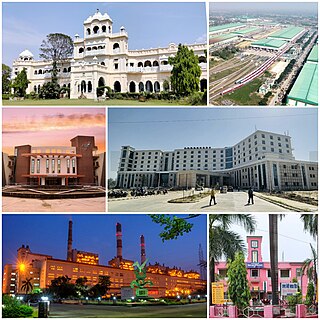
Raebareli is a city in Indian state of Uttar Pradesh. It is the administrative headquarters of Raebareli district and a part of Lucknow Division. The city is situated on the banks of the Sai river, 82 km (51 mi) southeast of Lucknow. It possesses many architectural features and sites, chief of which is a strong and spacious fort. As of 2011, Raebareli has a population of 191,316 people, in 35,197 households.

<span class="mw-page-title-main">Sultanpur district</span> District of Uttar Pradesh in India

Sultanpur district is a district in the Awadh region of the Indian state of Uttar Pradesh. This district is a part of Ayodhya division of the state. The administrative headquarters of the district is Sultanpur city. The total area of Sultanpur district is 2672.89 Sq. km.

<span class="mw-page-title-main">Ayodhya district</span> District in Uttar Pradesh, India

Ayodhya district is one of the 75 districts in the northern Indian state of Uttar Pradesh. The city of Ayodhya is its administrative headquarters. The district occupies an area of 2,522 square kilometres (974 sq mi), and had a population of 2,470,996 in the 2011 census. Ayodhya district shares its borders with 6 districts of Uttar Pradesh. It is bordered by Gonda and Basti districts on the northern side, Amethi and Sultanpur districts on the south, and Ambedkar Nagar and Barabanki districts share the border on the east and west.

<span class="mw-page-title-main">Jaunpur district</span> District in Uttar Pradesh, India

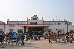
Jaunpur district is a district in the Varanasi Division of the Indian state of Uttar Pradesh. The district headquarters is the city of Jaunpur which is situated on the banks of the Gomti River. It is located 228 km southeast of the state capital Lucknow. 65 km northwest of Varanasi and 732 km southeast of New Delhi. The district has two Lok Sabha seats and nine Vidhan Sabha seats. According to the 2011 census, Jaunpur has a gender ratio of 1,018 females to 1,000 males, the highest in Uttar Pradesh. The main languages spoken in the district is Hindi and Urdu.

Bhadarsa is a town and nagar panchayat in Ayodhya district in state of Uttar Pradesh, India. Bhadarsa is 22 km south of district headquarters Ayodhya city.

<span class="mw-page-title-main">Gosainganj, Lucknow</span> Town in Uttar Pradesh, India

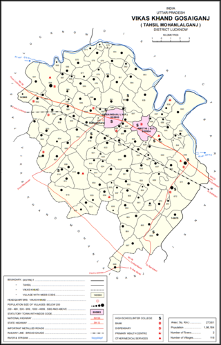
Gosainganj, also spelled Goshainganj or Gosaiganj is a town and nagar panchayat in Lucknow district of Uttar Pradesh, India. It is the seat of a community development block, which is included in the tehsil of Mohanlalganj. As of 2011, its population is 9,649, in 1,685 households. The starting point of the Purvanchal Expressway i.e. Chand Saray village is situated 2.5 km away from Gosainganj.

Jagdishpur is a town in Amethi in the Indian state of Uttar Pradesh.

<span class="mw-page-title-main">Musafirkhana</span> Town in Uttar Pradesh, India

Musafirkhana is a town and tehsil in Amethi district in Indian state of Uttar Pradesh. The word "Musafirkhana" means "Sarai," or "Dharamshala". Musafirkhana is located 32 km northwest of district headquarters Amethi.

<span class="mw-page-title-main">Akbarpur, Ambedkar Nagar</span> City in Uttar Pradesh, India

Akbarpur is a city, municipal corporation, tehsil, and the administrative headquarters of Ambedkar Nagar district in the state of Uttar Pradesh, India. It is a part of Ayodhya division.

Tanda is a town in Ambedkar Nagar district in the Indian state of Uttar Pradesh situated on the banks of Ghaghara River. It is a nagar palika parishad and is part of Ayodhya division in Uttar Pradesh. The town is situated 20 kilometres (12 mi) north east from district headquarter Akbarpur. Tanda is also a tehsil in the district. It has one of the largest handloom weaving industries for manufacturing varieties like gamchha, lungi, polyester clothing, check-shirt clothes material in state of Uttar Pradesh.

<span class="mw-page-title-main">Gauriganj, India</span> Town in Uttar Pradesh, India

Gauriganj is a city, municipal corporation, tehsil and administrative headquarters of Amethi district in Ayodhya division, Uttar Pradesh, India. It is situated about 126 km from the state capital Lucknow. Before July 2010, it was part of Sultanpur district. After that Gauriganj, Amethi, Jais, Jagdispur and Salon formed a new district Chhatrapati Sahuji Maharaj Nagar, later named Gauriganj and now Amethi. Gauriganj is connected with State Highway 34 and National Highway 128.

<span class="mw-page-title-main">Milkipur</span> Town in Uttar Pradesh, India

Milkipur is a town and tehsil in Ayodhya district in the Indian state of Uttar Pradesh. Milkipur is 32 km south of district headquarters Ayodhya city. District Ayodhya consists of 11 blocks and Milkipur is a block in Ayodhya, Uttar Pradesh.

Kurebhar is a town in Sultanpur district of the Uttar Pradesh state in India. Kurebhar is 20 km north of district headquarters Sultanpur city.

<span class="mw-page-title-main">Amethi district</span> District in Uttar Pradesh, India

Amethi is one of the 75 districts of the northern Indian state of Uttar Pradesh. This district is a part of Ayodhya division in the Awadh region of Uttar Pradesh. It covers an area of 2,329.11 km2. Gauriganj is the administrative headquarters of the district.

Adhanpur is a big village in the Amethi district of Uttar Pradesh, India. State, India. It belongs to Ayodhya Division. It is located 43 km to the west of District headquarters Sultanpur. 10 km from Musafir Khana. 107 km from State capital Lucknow

Rajesultanpur or Raje Sultanpur is a town and nagar panchayat in Ambedkar Nagar district in the Indian state of Uttar Pradesh.

Amaniganj is a town in Milkipur tehsil, Ayodhya district in the Indian state of Uttar Pradesh. Amaniganj is situated on Milkipur-Rudauli road and is 51 km away from district headquarters Ayodhya city. Amaniganj is a block in Ayodhya, Uttar Pradesh.

Haiderganj is a town in Bikapur tehsil in Ayodhya district of Uttar Pradesh state of India. Haiderganj is 40 km south of district headquarters Ayodhya city.

References

  1. 1 2 "Census of India: Sultanpur". www.censusindia.gov.in. Retrieved 20 November 2019.
  2. 1 2 "52nd Report of the Commissioner for Linguistic Minorities in India" (PDF). nclm.nic.in. Ministry of Minority Affairs. Archived from the original (PDF) on 25 May 2017. Retrieved 11 January 2019.
  3. "About District | District Sultanpur, Government of Uttar Pradesh" . Retrieved 12 August 2021.
  4. 1 2 3 4 5 6 7 8 9 10 11 12 13 14 15 16 17 18 19 20 21 Nevill, H.R. (1903). Sultanpur: A Gazetteer, Being Volume XLVI Of The District Gazetteers Of The United Provinces Of Agra And Oudh. Allahabad: Government Press. pp. 204–8. Retrieved 6 September 2021.
  5. Tyagi, Harshita (24 November 2020). "UP Cabinet clears proposal to rename Ayodhya Airport as Maryada Purushottam Sri Ram Airport". Times Now. Retrieved 22 February 2021.
  6. "-::- Welcome to RANA PRATAP POST GRADUATE COLLEGE Sultanpur". www.rppgsultanpur.org. Retrieved 11 February 2020.
  7. ":: KNIPSS Sultanpur U.P." knipss.ac.in. Retrieved 11 February 2020.
  8. ":::KNIPSS::Management Institute Sultanpur U.P." www.knmt.org.in. Retrieved 11 February 2020.
  9. "Members Profile - Khan, Shri Mohammad Tahir". loksabhaph.nic.in. Retrieved 18 February 2022.