Supercontinent cycle

Last updated
Map of Pangaea with modern continental outlines Pangaea continents.svg
Map of Pangaea with modern continental outlines

The supercontinent cycle is the quasi-periodic aggregation and dispersal of Earth's continental crust. There are varying opinions as to whether the amount of continental crust is increasing, decreasing, or staying about the same, but it is agreed that the Earth's crust is constantly being reconfigured. One complete supercontinent cycle is said to take 300 to 500 million years. Continental collision makes fewer and larger continents while rifting makes more and smaller continents.

Contents

Theory

Simplified representation of the proposed series of supercontinents to the modern day Platetechsimple.png
Simplified representation of the proposed series of supercontinents to the modern day

The most recent supercontinent, Pangaea, formed about 300 million years ago (0.3 Ga), during the Paleozoic era. There are two different views on the history of earlier supercontinents.

Series

The first theory proposes a series of supercontinents: starting with Vaalbara (3.6 to 2.8 Ga); Ur (c. 3 Ga); Kenorland (2.7 to 2.1 Ga); Columbia (1.8 to 1.5 Ga); Rodinia (1.25  to .75 Ga); and Pannotia (c. 600 Ma), whose dispersal produced the continents that ultimately collided to form Pangaea. [1] [2]

The kinds of minerals found inside ancient diamonds suggest that the cycle of supercontinental formation and breakup began roughly 3 Ga. Before 3.2 Ga, only diamonds with peridotitic compositions (commonly found in the Earth's mantle) formed, whereas after 3.0 Ga eclogitic diamonds (rocks from the Earth's crust) became prevalent. This change is thought to have come about as subduction and continental collision introduced eclogite into subcontinental diamond-forming fluids. [3]

The supercontinent cycle and the Wilson cycle produced the supercontinents Rodinia and Pangaea Wilson-cycle hg.svg
The supercontinent cycle and the Wilson cycle produced the supercontinents Rodinia and Pangaea

The hypothesized supercontinent cycle is concurrent with the shorter-term Wilson Cycle named after plate tectonics pioneer John Tuzo Wilson, which describes the periodic opening and closing of oceanic basins from a single plate rift. The oldest seafloor material found today dates to 170 Ma, whereas the oldest continental crust material found today dates to 4 Ga, showing the relative brevity of the regional Wilson cycles compared to the whole-planetary pulses seen in the arrangement of the continents.

Protopangea–Paleopangea

The second view, based on both palaeomagnetic and geological evidence, is that supercontinent cycles did not occur before about 0.6 Ga (during the Ediacaran period). Instead, the continental crust comprised a single supercontinent from about 2.7 Ga until it broke up for the first time, somewhere around 0.6 Ga. This reconstruction [4] is based on the observation that if only small peripheral modifications are made to the primary reconstruction, the data show that the palaeomagnetic poles converged to quasi-static positions for long intervals between about 2.7–2.2 Ga; 1.5–1.25 Ga; and 0.75–0.6 Ga. [5] During the intervening periods, the poles appear to have conformed to a unified apparent polar wander path.

The paleomagnetic data are adequately explained by the existence of a single Protopangea–Paleopangea supercontinent with prolonged quasi-integrity. The prolonged duration of this supercontinent could be explained by the operation of lid tectonics (comparable to the tectonics operating on Mars and Venus) during Precambrian times, as opposed to the plate tectonics seen on the contemporary Earth. [4] However, this approach is widely criticized as an incorrect application of paleomagnetic data. [6]

Effects on sea level

It is known that sea level is generally low when the continents are together and high when they are apart. For example, sea level was low at the time of formation of Pangaea (Permian) and Pannotia (latest Neoproterozoic), and rose rapidly to maxima during Ordovician and Cretaceous times, when the continents were dispersed.

Major influences on sea level during the break up of supercontinents include: oceanic crust age, lost back-arc basins, marine sediment depths, emplacement of large igneous provinces, and the effect of passive margin extension. Of these, oceanic crust age, and marine sediment depths seem to play some of the largest roles in creating a sea level model. The addition of the other controlling parameters help stabilize models when data is sparse. [7]

The age of the oceanic lithosphere provides a first order control on the depth of the ocean basins, and therefore on global sea level. Oceanic lithosphere forms at mid-ocean ridges and moves outwards, conductively cooling and shrinking, which decreases the thickness and increases the density of the oceanic lithosphere, and lowers the seafloor away from mid-ocean ridges. For oceanic lithosphere that is less than about 75 Ma, a simple cooling half-space model of conductive cooling works, in which the depth of the ocean basins d in areas in which there is no nearby subduction is a function of the age of the oceanic lithosphere t. In general,

where κ is the thermal diffusivity of the mantle lithosphere (c.8×10−7  m 2/s ), aeff is the effective thermal expansion coefficient for rock (c.5.7×10−5 °C−1), T1 is the temperature of ascending magma compared to the temperature at the upper boundary (c. 1220 °C for the Atlantic and Indian Oceans, c. 1120 °C for the eastern Pacific) and dr is the depth of the ridge below the ocean surface. [8] After plugging in rough numbers for the sea floor, the equation becomes:

for the eastern Pacific Ocean:

and for the Atlantic and Indian Oceans:

where d is in meters and t is in millions of years, so that recently-formed crust at the mid-ocean ridges lies at about 2,500 m depth, whereas 50-million-year-old seafloor lies at a depth of about 5,000 m. [9] As the mean level of the sea floor decreases, the volume of the ocean basins increases, and if other factors that can control sea level remain constant, sea level falls. The converse is also true: younger oceanic lithosphere leads to shallower oceans and higher sea levels if other factors remain constant.

The surface area of the oceans can change when continents rift (stretching the continents decreases ocean area and raises sea level) or as a result of continental collision (compressing the continents increases ocean area and lowers sea level). Increasing sea level will flood the continents, while decreasing sea level will expose continental shelves. Because the continental shelf has a very low slope, a small increase in sea level will result in a large change in the percent of continents flooded.

If the world ocean on average is young, the seafloor will be relatively shallow, and sea level will be high: more of the continents are flooded. If the world ocean is on average old, seafloor will be relatively deep, and sea level will be low: more of the continents will be exposed. There is thus a relatively simple relationship between the supercontinent cycle and the mean age of the seafloor.

There will also be a climatic effect of the supercontinent cycle that will amplify this further:

Relation to global tectonics

There is a progression of tectonic regimes that accompanies the supercontinent cycle:

During break-up of the supercontinent, rifting environments dominate. This is followed by passive margin environments, while seafloor spreading continues and the oceans grow. This in turn is followed by the development of collisional environments that become increasingly important with time. First collisions are between continents and island arcs, but lead ultimately to continent-continent collisions. This was the situation during the Paleozoic supercontinent cycle; it is being observed for the MesozoicCenozoic supercontinent cycle, still in progress.

Relation to climate

There are two types of global earth climates: icehouse and greenhouse. Icehouse is characterized by frequent continental glaciations and severe desert environments. Greenhouse is characterized by warm climates. Both reflect the supercontinent cycle. The Earth is currently in a short greenhouse phase of an icehouse climate. [10] Periods of icehouse climate include much of the Neoproterozoic, late Paleozoic, late Cenozoic, while periods of greenhouse climate include early Paleozoic, Mesozoic–early Cenozoic.

Relation to evolution

The principal mechanism for evolution is natural selection among diverse populations. Diversity, as measured by the number of families, follows the supercontinent cycle very well. [11] As genetic drift occurs more frequently in small populations, diversity is an observed consequence of geographic isolation. Less isolation, and thus less diversification, occurs when the continents are all together, producing one continent, one continuous coast, and one ocean. In late Neoproterozoic to early Paleozoic, when the tremendous proliferation of diverse metazoa occurred, isolation of marine environments resulted from the breakup of Pannotia.

A north–south arrangement of continents and oceans leads to much more diversity and isolation than east–west arrangements. North-to-south arrangements give climatically different zones along the communication routes to the north and south, which are separated by water or land from other continental or oceanic zones of similar climate. Formation of similar tracts of continents and ocean basins oriented east–west would lead to much less isolation, diversification, and slower evolution, since each continent or ocean is in fewer climatic zones. Through the Cenozoic, isolation has been maximized by a north–south arrangement.

See also

Related Research Articles

<span class="mw-page-title-main">Plate tectonics</span> Movement of Earths lithosphere

Plate tectonics is the scientific theory that Earth's lithosphere comprises a number of large tectonic plates, which have been slowly moving since about 3.4 billion years ago. The model builds on the concept of continental drift, an idea developed during the first decades of the 20th century. Plate tectonics came to be accepted by geoscientists after seafloor spreading was validated in the mid-to-late 1960s.

<span class="mw-page-title-main">Supercontinent</span> Landmass comprising more than one continental core, or craton

In geology, a supercontinent is the assembly of most or all of Earth's continental blocks or cratons to form a single large landmass. However, some geologists use a different definition, "a grouping of formerly dispersed continents", which leaves room for interpretation and is easier to apply to Precambrian times. To separate supercontinents from other groupings, a limit has been proposed in which a continent must include at least about 75% of the continental crust then in existence in order to qualify as a supercontinent.

Rodinia was a Mesoproterozoic and Neoproterozoic supercontinent that assembled 1.26–0.90 billion years ago (Ga) and broke up 750–633 million years ago (Ma). Valentine & Moores 1970 were probably the first to recognise a Precambrian supercontinent, which they named "Pangaea I." It was renamed "Rodinia" by McMenamin & McMenamin 1990 who also were the first to produce a reconstruction and propose a temporal framework for the supercontinent.

<span class="mw-page-title-main">Orogeny</span> The formation of mountain ranges

Orogeny is a mountain-building process that takes place at a convergent plate margin when plate motion compresses the margin. An orogenic belt or orogen develops as the compressed plate crumples and is uplifted to form one or more mountain ranges. This involves a series of geological processes collectively called orogenesis. These include both structural deformation of existing continental crust and the creation of new continental crust through volcanism. Magma rising in the orogen carries less dense material upwards while leaving more dense material behind, resulting in compositional differentiation of Earth's lithosphere. A synorogenic process or event is one that occurs during an orogeny.

<span class="mw-page-title-main">Seafloor spreading</span> Geological process at mid-ocean ridges

Seafloor spreading, or seafloor spread, is a process that occurs at mid-ocean ridges, where new oceanic crust is formed through volcanic activity and then gradually moves away from the ridge.

<span class="mw-page-title-main">Subduction</span> A geological process at convergent tectonic plate boundaries where one plate moves under the other

Subduction is a geological process in which the oceanic lithosphere and some continental lithosphere is recycled into the Earth's mantle at convergent boundaries. Where the oceanic lithosphere of a tectonic plate converges with the less dense lithosphere of a second plate, the heavier plate dives beneath the second plate and sinks into the mantle. A region where this process occurs is known as a subduction zone, and its surface expression is known as an arc-trench complex. The process of subduction has created most of the Earth's continental crust. Rates of subduction are typically measured in centimeters per year, with rates of convergence as high as 11 cm/year.

<span class="mw-page-title-main">Rift</span> Geological linear zone where the lithosphere is being pulled apart

In geology, a rift is a linear zone where the lithosphere is being pulled apart and is an example of extensional tectonics. Typical rift features are a central linear downfaulted depression, called a graben, or more commonly a half-graben with normal faulting and rift-flank uplifts mainly on one side. Where rifts remain above sea level they form a rift valley, which may be filled by water forming a rift lake. The axis of the rift area may contain volcanic rocks, and active volcanism is a part of many, but not all, active rift systems.

<span class="mw-page-title-main">Continental crust</span> Layer of rock that forms the continents and continental shelves

Continental crust is the layer of igneous, metamorphic, and sedimentary rocks that forms the geological continents and the areas of shallow seabed close to their shores, known as continental shelves. This layer is sometimes called sial because its bulk composition is richer in aluminium silicates (Al-Si) and has a lower density compared to the oceanic crust, called sima which is richer in magnesium silicate (Mg-Si) minerals. Changes in seismic wave velocities have shown that at a certain depth, there is a reasonably sharp contrast between the more felsic upper continental crust and the lower continental crust, which is more mafic in character.

<span class="mw-page-title-main">Kenorland</span> Hypothetical Neoarchaean supercontinent from about 2.8 billion years ago

Kenorland was one of the earliest known supercontinents on Earth. It is thought to have formed during the Neoarchaean Era c. 2.72 billion years ago by the accretion of Neoarchaean cratons and the formation of new continental crust. It comprised what later became Laurentia, Baltica, Western Australia and Kalaharia.

<span class="mw-page-title-main">Pannotia</span> Hypothesized Neoproterozoic supercontinent

Pannotia, also known as the Vendian supercontinent, Greater Gondwana, and the Pan-African supercontinent, was a relatively short-lived Neoproterozoic supercontinent that formed at the end of the Precambrian during the Pan-African orogeny, during the Cryogenian period and broke apart 560 Ma with the opening of the Iapetus Ocean, in the late Ediacaran and early Cambrian. Pannotia formed when Laurentia was located adjacent to the two major South American cratons, Amazonia and Río de la Plata. The opening of the Iapetus Ocean separated Laurentia from Baltica, Amazonia, and Río de la Plata. A 2022 paper argues that Pannotia never fully existed, reinterpreting the geochronological evidence: "the supposed landmass had begun to break up well before it was fully assembled". However, the assembly of the next supercontinent Pangaea is well established.

In hydrology, an oceanic basin (or ocean basin) is anywhere on Earth that is covered by seawater. Geologically, most of the ocean basins are large geologic basins that are below sea level.

<span class="mw-page-title-main">Continental collision</span> Phenomenon in which mountains can be produced on the boundaries of converging tectonic plates

In geology, continental collision is a phenomenon of plate tectonics that occurs at convergent boundaries. Continental collision is a variation on the fundamental process of subduction, whereby the subduction zone is destroyed, mountains produced, and two continents sutured together. Continental collision is only known to occur on Earth.

<span class="mw-page-title-main">Wilson Cycle</span> Geophysical model of the opening and closing of rifts

The Wilson Cycle is a model that describes the opening and closing of ocean basins and the subduction and divergence of tectonic plates during the assembly and disassembly of supercontinents. A classic example of the Wilson Cycle is the opening and closing of the Atlantic Ocean. It has been suggested that Wilson cycles on Earth started about 3 Ga in the Archean Eon. The Wilson Cycle model was a key development in the theory of plate tectonics during the Plate Tectonics Revolution.

<span class="mw-page-title-main">Geological history of Earth</span> The sequence of major geological events in Earths past

The geological history of the Earth follows the major geological events in Earth's past based on the geological time scale, a system of chronological measurement based on the study of the planet's rock layers (stratigraphy). Earth formed about 4.54 billion years ago by accretion from the solar nebula, a disk-shaped mass of dust and gas left over from the formation of the Sun, which also created the rest of the Solar System.

<span class="mw-page-title-main">Laurentia</span> Craton forming the geological core of North America

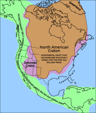
Laurentia or the North American Craton is a large continental craton that forms the ancient geological core of North America. Many times in its past, Laurentia has been a separate continent, as it is now in the form of North America, although originally it also included the cratonic areas of Greenland and also the northwestern part of Scotland, known as the Hebridean Terrane. During other times in its past, Laurentia has been part of larger continents and supercontinents and consists of many smaller terranes assembled on a network of early Proterozoic orogenic belts. Small microcontinents and oceanic islands collided with and sutured onto the ever-growing Laurentia, and together formed the stable Precambrian craton seen today.

<span class="mw-page-title-main">Pangaea</span> Supercontinent from the late Paleozoic to early Mesozoic eras

Pangaea or Pangea was a supercontinent that existed during the late Paleozoic and early Mesozoic eras. It assembled from the earlier continental units of Gondwana, Euramerica and Siberia during the Carboniferous approximately 335 million years ago, and began to break apart about 200 million years ago, at the end of the Triassic and beginning of the Jurassic. In contrast to the present Earth and its distribution of continental mass, Pangaea was C-shaped, with the bulk of its mass stretching between Earth's northern and southern polar regions and surrounded by the superocean Panthalassa and the Paleo-Tethys and subsequent Tethys Oceans. Pangaea is the most recent supercontinent to have existed and the first to be reconstructed by geologists.

This is a list of articles related to plate tectonics and tectonic plates.

<span class="mw-page-title-main">East Antarctic Shield</span> Cratonic rock body which makes up most of the continent Antarctica

The East Antarctic Shield or Craton is a cratonic rock body that covers 10.2 million square kilometers or roughly 73% of the continent of Antarctica. The shield is almost entirely buried by the East Antarctic Ice Sheet that has an average thickness of 2200 meters but reaches up to 4700 meters in some locations. East Antarctica is separated from West Antarctica by the 100–300 kilometer wide Transantarctic Mountains, which span nearly 3,500 kilometers from the Weddell Sea to the Ross Sea. The East Antarctic Shield is then divided into an extensive central craton that occupies most of the continental interior and various other marginal cratons that are exposed along the coast.

<span class="mw-page-title-main">Huangling Anticline</span>

The Huangling Anticline or Complex represents a group of rock units that appear in the middle of the Yangtze Block in South China, distributed across Yixingshan, Zigui, Huangling, and Yichang counties. The group of rock involves nonconformity that sedimentary rocks overlie the metamorphic basement. It is a 73-km long, asymmetrical dome-shaped anticline with axial plane orientating in the north-south direction. It has a steeper west flank and a gentler east flank. Basically, there are three tectonic units from the anticline core to the rim, including Archean to Paleoproterozoic metamorphic basement, Neoproterozoic to Jurassic sedimentary rocks, and Cretaceous fluvial deposit sedimentary cover. The northern part of the core is mainly tonalite-trondhjemite-gneiss (TTG) and Cretaceous sedimentary rock called the Archean Kongling Complex. The middle of the core is mainly the Neoproterozoic granitoid. The southern part of the core is the Neoproterozoic potassium granite. Two basins are situated on the western and eastern flanks of the core, respectively, including the Zigui basin and Dangyang basin. Both basins are synforms while Zigui basin has a larger extent of folding. Yuanan Graben and Jingmen Graben are found within the Dangyang Basin area. The Huangling Anticline is an important area that helps unravel the tectonic history of the South China Craton because it has well-exposed layers of rock units from Archean basement rock to Cretaceous sedimentary rock cover due to the erosion of the anticline.

<span class="mw-page-title-main">Tectonic evolution of Patagonia</span>

Patagonia comprises the southernmost region of South America, portions of which lie on either side of the Argentina-Chile border. It has traditionally been described as the region south of the Rio, Colorado, although the physiographic border has more recently been moved southward to the Huincul fault. The region's geologic border to the north is composed of the Rio de la Plata craton and several accreted terranes comprising the La Pampa province. The underlying basement rocks of the Patagonian region can be subdivided into two large massifs: the North Patagonian Massif and the Deseado Massif. These massifs are surrounded by sedimentary basins formed in the Mesozoic that underwent subsequent deformation during the Andean orogeny. Patagonia is known for its vast earthquakes and the damage they cause.

References

  1. Zhao, Guochun; Cawood, Peter A.; Wilde, Simon A.; Sun, M. (2002). "Review of global 2.1–1.8 Ga orogens: implications for a pre-Rodinia supercontinent". Earth-Science Reviews. 59 (1–4): 125–162. Bibcode:2002ESRv...59..125Z. doi:10.1016/S0012-8252(02)00073-9.
  2. Zhao, Guochun; Sun, M.; Wilde, Simon A.; Li, S. Z. (2004). "A Paleo-Mesoproterozoic supercontinent: assembly, growth and breakup". Earth-Science Reviews. 67 (1–2): 91–123. Bibcode:2004ESRv...67...91Z. doi:10.1016/j.earscirev.2004.02.003.
  3. Shirey, S. B.; Richardson, S. H. (2011). "Start of the Wilson Cycle at 3 Ga Shown by Diamonds from Subcontinental Mantle". Science. 333 (6041): 434–436. Bibcode:2011Sci...333..434S. doi:10.1126/science.1206275. PMID   21778395.
  4. 1 2 Piper, J. D. A. (2013). "A planetary perspective on Earth evolution: Lid Tectonics before Plate Tectonics". Tectonophysics. 589: 44–56. Bibcode:2013Tectp.589...44P. doi:10.1016/j.tecto.2012.12.042.
  5. Piper, J. D. A. (2013). "Continental velocity through geological time: the link to magmatism, crustal accretion and episodes of global cooling". Geoscience Frontiers. 4: 7–36. doi: 10.1016/j.gsf.2012.05.008 .
  6. Z.X, Li (October 2009). "How not to build a supercontinent: A reply to J.D.A. Piper". Precambrian Research. 174 (1–2): 208–214. doi:10.1016/j.precamres.2009.06.007.
  7. Wright, N. M., Seton, M., Williams, S., Whittaker, J. M., & Müller, R. D. (2020). Sea-level fluctuations driven by changes in global ocean basin volume following supercontinent break-up. Earth-Science Reviews. doi : 10.1016/j.earscirev.2020.103293
  8. E. E., Davis; Lister, C. R. B. (1974). "Fundamentals of Ridge Crest Topography". Earth and Planetary Science Letters. 21 (4): 405–413. Bibcode:1974E&PSL..21..405D. doi:10.1016/0012-821X(74)90180-0.
  9. Parsons, Barry; Sclater, John G. (1977). "An analysis of the variation of ocean floor bathymetry and heat flow with age". Journal of Geophysical Research. 82 (B5): 802–827. Bibcode:1977JGR....82..802P. doi:10.1029/jb082i005p00803.
  10. Read, J. Fred (2001). "Record of ancient climates can be a map to riches". Science from Virginia Tech. Retrieved 2011-05-04.
  11. Benton, Michael J. (23 September 2005). "Fossil Record: Quality". eLS. John Wiley & Sons, Ltd. doi:10.1038/npg.els.0004144. ISBN   978-0470016176.{{cite book}}: |journal= ignored (help)

Further reading

Commons-logo.svg Media related to Supercontinents at Wikimedia Commons