Apache Junction is a city in Pinal and Maricopa County, Arizona, United States. As of the 2020 census, the population was 38,499, most of whom lived in Pinal County. It is named for the junction of the Apache Trail and Old West Highway. The area where Apache Junction is located used to be known as Youngberg. Superstition Mountain, the westernmost peak of the Superstition Mountains, is to the east.

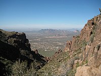
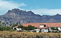
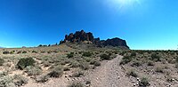
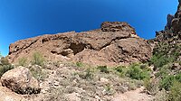
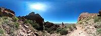
Superstition Mountain is a prominent mountain and regional landmark located in the Phoenix metropolitan area of Arizona, immediately east of Apache Junction and north of Gold Canyon. It anchors the west end of the Superstition Mountains and is a popular outdoor recreation destination, home to numerous trails for hiking and horseback riding. The legend of the Lost Dutchman's Gold Mine centers around the mountain.

The Peralta Stones are a set of engraved stones suppsedly indicating the location of the Lost Dutchman's Gold Mine, in Arizona, United States.

The Tonto National Forest, encompassing 2,873,200 acres, is the largest of the six national forests in Arizona and is the ninth largest national forest in the United States. The forest has diverse scenery, with elevations ranging from 1,400 feet in the Sonoran Desert to 7,400 feet in the ponderosa pine forests of the Mogollon Rim. The Tonto National Forest is also the most visited "urban" forest in the United States.

The Lost Dutchman's Gold Mine is, according to legend, a rich gold mine hidden in the southwestern United States. The location is generally believed to be in the Superstition Mountains, near Apache Junction, east of Phoenix, Arizona. There have been many stories about how to find the mine, and each year people search for the mine. Some have died on the search.

Mount Nebo is the southernmost and highest mountain in the Wasatch Range of Utah, in the United States, and the centerpiece of the Mount Nebo Wilderness, inside the Uinta National Forest. It is named after the biblical Mount Nebo, overlooking Israel from the east of the Jordan River, which is said to be the place of Moses' death.

Camelback Mountain is a mountain in Phoenix, Arizona, United States. The English name is derived from its shape, which resembles the hump and head of a kneeling camel. The mountain, a prominent landmark of the Phoenix metropolitan area, is located in the Camelback Mountain Echo Canyon Recreation Area between the Arcadia neighborhood of Phoenix and the town of Paradise Valley. It is a popular recreation destination for hiking and rock climbing.

Tortilla Flat is a small unincorporated community in far eastern Maricopa County, Arizona, United States. It is located in the central part of the state, northeast of Apache Junction. It is the last surviving stagecoach stop along the Apache Trail. According to the Gross Management Department of Arizona's main U.S. Post Office in Phoenix, Tortilla Flat is presumed to be Arizona's smallest official "community" having a U.S. Post Office and voting precinct. The town has a population of 6. Tortilla Flat can be reached by vehicles on the Apache Trail, via Apache Junction.
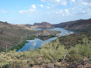
Canyon Lake is one of four reservoirs that were formed by the damming of the Salt River in the U.S. state of Arizona as part of the Salt River Project. It was formed by the Mormon Flat Dam, which was completed in 1925 after two years of construction. Canyon Lake, with a surface area of 950 acres (380 ha), is the third and smallest of the four lakes created along the river. Two others, Apache Lake and Roosevelt Lake, are upstream. The fourth, Saguaro Lake, is downstream.

Mount Wrightson is a 9,456-foot (2,882 m) peak in the Santa Rita Mountains within the Coronado National Forest, in southern Arizona, United States.

Four Peaks is a prominent landmark on the eastern skyline of Phoenix. Part of the Mazatzal Mountains, it is located in the Four Peaks Wilderness in the Tonto National Forest, 40 miles (64 km) east-northeast of Phoenix. In winter, Four Peaks offers much of the Phoenix metro area a view of snow-covered peaks. Four Peaks is the site of an amethyst mine that produces top-grade amethyst.

The following is an alphabetical list of articles related to the U.S. state of Arizona.
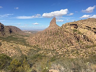
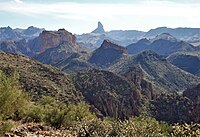
Weavers Needle is a 1,000-foot-high (300 m) column of rock that forms a distinctive peak visible for many miles around. Located in the Superstition Mountains east of Phoenix, Arizona, Weavers Needle was created when a thick layer of tuff —a volcanic plug—was heavily eroded, creating the spire as an erosional remnant with a summit elevation of 4,555 feet (1,388 m). It is set in a desert landscape of cactus and mesquite bush, with large Saguaro cacti particularly prominent. The peak was named after mountain man Pauline Weaver.
The Peralta massacre was the alleged killing of a Mexican family by Apaches in about 1848. It is generally featured as an element of the legend of the Lost Dutchman's Gold Mine.

Mount Baldy is an extinct stratovolcano in eastern Arizona in the United States. With a summit elevation of 11,409 feet (3,477 m), the peak of Mount Baldy rises above the tree line and is left largely bare of vegetation, lending the mountain its current name. The Mount Baldy Wilderness occupies the eastern slope of the mountain and is managed by the Apache-Sitgreaves National Forest.

The Huachuca Mountains are part of the Sierra Vista Ranger District of the Coronado National Forest in Cochise County in southeastern Arizona, approximately 70 miles (110 km) south-southeast of Tucson and southwest of the city of Sierra Vista. Included in this area is the highest peak in the Huachucas, Miller Peak, and the region of the Huachucas known as Canelo Hills in eastern Santa Cruz County. The mountains range in elevation from 3,934 feet (1,199 m) at the base to 9,466 feet (2,885 m) at the top of Miller Peak. The second highest peak in this range is Carr Peak, elevation 9,200 feet (2,804 m). The Huachuca Mountain area is managed principally by the United States Forest Service (41%) and the U.S. Army (20%), with much of the rest being private land (32%). Sierra Vista is the main population center.

Lost Dutchman State Park is a 320-acre (129 ha) state park located in northwestern Pinal County, Arizona on the Apache Trail north of Apache Junction, near the Superstition Mountains in central Arizona. It is named after the Lost Dutchman's Gold Mine, a famously lost gold mine legendary in the tales of the Old West. It is accessible about 40 miles (64 km) east of Phoenix via U.S. Highway 60, the Superstition Freeway.

Carr Peak is the third-highest mountain in Cochise County, Arizona and is the second-highest mountain in the Huachuca Mountains. It rises about 10 miles (16 km) south of Sierra Vista, Arizona. The summit is in the Miller Peak Wilderness on the Coronado National Forest and about 4 miles (6 km) south of the Nature Conservancy's Ramsey Canyon Preserve. The area is well known among birders because of the variety of hummingbird species seen in the area as well as the dozens of southwestern specialties such as Apache pine, Chihuahua pine, ridge-nosed rattlesnake, lesser long-nosed bat and elegant trogon.

Apache Peak, at 7,714 feet (2,351 m), is the highest peak in the Whetstone Mountains in Cochise County, Arizona. The summit, located in the Coronado National Forest, is a popular local hiking destination. It is located near the Kartchner Caverns State Park, the city of Benson, Interstate 10, and Arizona State Route 90.

Silly Mountain, also known as "Roadside Benchmark", is a mountain in Arizona, United States, located near the city of Apache Junction. It is part of the Superstition Mountain range. The elevation of the mountain is 2,139 feet (652 m), and the prominence is 358 feet (109 m).