Stormwater, also written storm water, is water that originates from precipitation (storm), including heavy rain and meltwater from hail and snow. Stormwater can soak into the soil (infiltrate) and become groundwater, be stored on depressed land surface in ponds and puddles, evaporate back into the atmosphere, or contribute to surface runoff. Most runoff is conveyed directly as surface water to nearby streams, rivers or other large water bodies without treatment.

A retention basin, sometimes called a retention pond,wet detention basin, or storm water management pond (SWMP), is an artificial pond with vegetation around the perimeter and a permanent pool of water in its design. It is used to manage stormwater runoff, for protection against flooding, for erosion control, and to serve as an artificial wetland and improve the water quality in adjacent bodies of water.

Bioswales are channels designed to concentrate and convey stormwater runoff while removing debris and pollution. Bioswales can also be beneficial in recharging groundwater.
The United States Environmental Protection Agency (EPA) Storm Water Management Model (SWMM) is a dynamic rainfall–runoff–subsurface runoff simulation model used for single-event to long-term (continuous) simulation of the surface/subsurface hydrology quantity and quality from primarily urban/suburban areas.

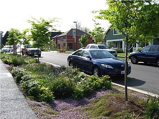
Rain gardens, also called bioretention facilities, are one of a variety of practices designed to increase rain runoff reabsorption by the soil. They can also be used to treat polluted stormwater runoff. Rain gardens are designed landscape sites that reduce the flow rate, total quantity, and pollutant load of runoff from impervious urban areas like roofs, driveways, walkways, parking lots, and compacted lawn areas. Rain gardens rely on plants and natural or engineered soil medium to retain stormwater and increase the lag time of infiltration, while remediating and filtering pollutants carried by urban runoff. Rain gardens provide a method to reuse and optimize any rain that falls, reducing or avoiding the need for additional irrigation. A benefit of planting rain gardens is the consequential decrease in ambient air and water temperature, a mitigation that is especially effective in urban areas containing an abundance of impervious surfaces that absorb heat in a phenomenon known as the heat-island effect.

First flush is the initial surface runoff of a rainstorm. During this phase, water pollution entering storm drains in areas with high proportions of impervious surfaces is typically more concentrated compared to the remainder of the storm. Consequently, these high concentrations of urban runoff result in high levels of pollutants discharged from storm sewers to surface waters.

Surface runoff is the unconfined flow of water over the ground surface, in contrast to channel runoff. It occurs when excess rainwater, stormwater, meltwater, or other sources, can no longer sufficiently rapidly infiltrate in the soil. This can occur when the soil is saturated by water to its full capacity, and the rain arrives more quickly than the soil can absorb it. Surface runoff often occurs because impervious areas do not allow water to soak into the ground. Furthermore, runoff can occur either through natural or human-made processes.

Sustainable drainage systems are a collection of water management practices that aim to align modern drainage systems with natural water processes and are part of a larger green infrastructure strategy. SuDS efforts make urban drainage systems more compatible with components of the natural water cycle such as storm surge overflows, soil percolation, and bio-filtration. These efforts hope to mitigate the effect human development has had or may have on the natural water cycle, particularly surface runoff and water pollution trends.
Green infrastructure or blue-green infrastructure refers to a network that provides the “ingredients” for solving urban and climatic challenges by building with nature. The main components of this approach include stormwater management, climate adaptation, the reduction of heat stress, increasing biodiversity, food production, better air quality, sustainable energy production, clean water, and healthy soils, as well as more anthropocentric functions, such as increased quality of life through recreation and the provision of shade and shelter in and around towns and cities. Green infrastructure also serves to provide an ecological framework for social, economic, and environmental health of the surroundings. More recently scholars and activists have also called for green infrastructure that promotes social inclusion and equity rather than reinforcing pre-existing structures of unequal access to nature-based services.
Bioretention is the process in which contaminants and sedimentation are removed from stormwater runoff. The main objective of the bioretention cell is to attenuate peak runoff as well as to remove stormwater runoff pollutants.

A buffer strip is an area of land maintained in permanent vegetation that helps to control air quality, soil quality, and water quality, along with other environmental problems, dealing primarily on land that is used in agriculture. Buffer strips trap sediment, and enhance filtration of nutrients and pesticides by slowing down surface runoff that could enter the local surface waters. The root systems of the planted vegetation in these buffers hold soil particles together which alleviate the soil of wind erosion and stabilize stream banks providing protection against substantial erosion and landslides. Farmers can also use buffer strips to square up existing crop fields to provide safety for equipment while also farming more efficiently.

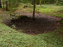
An infiltration basin is a form of engineered sump or percolation pond that is used to manage stormwater runoff, prevent flooding and downstream erosion, and improve water quality in an adjacent river, stream, lake or bay. It is essentially a shallow artificial pond that is designed to infiltrate stormwater through permeable soils into the groundwater aquifer. Infiltration basins do not release water except by infiltration, evaporation or emergency overflow during flood conditions.

A percolation trench, also called an infiltration trench, is a type of best management practice (BMP) that is used to manage stormwater runoff, prevent flooding and downstream erosion, and improve water quality in an adjacent river, stream, lake or bay. It is a shallow excavated trench filled with gravel or crushed stone that is designed to infiltrate stormwater though permeable soils into the groundwater aquifer.
Urban runoff is surface runoff of rainwater, landscape irrigation, and car washing created by urbanization. Impervious surfaces are constructed during land development. During rain, storms, and other precipitation events, these surfaces, along with rooftops, carry polluted stormwater to storm drains, instead of allowing the water to percolate through soil. This causes lowering of the water table and flooding since the amount of water that remains on the surface is greater. Most municipal storm sewer systems discharge untreated stormwater to streams, rivers, and bays. This excess water can also make its way into people's properties through basement backups and seepage through building wall and floors.

A check dam is a small, sometimes temporary, dam constructed across a swale, drainage ditch, or waterway to counteract erosion by reducing water flow velocity. Check dams themselves are not a type of new technology; rather, they are an ancient technique dating from the second century AD. Check dams are typically, though not always, implemented in a system of several dams situated at regular intervals across the area of interest.

Stormwater harvesting or Stormwater reuse is the collection, accumulation, treatment or purification, and storage of stormwater for its eventual reuse. While rainwater harvesting collects precipitation primarily from rooftops, stormwater harvesting deals with collection of runoff from creeks, gullies, ephemeral streams, underground conveyances. It can also include catchment areas from developed surfaces, such as roads or parking lots, or other urban environments such as parks, gardens and playing fields.

Water-sensitive urban design (WSUD) is a land planning and engineering design approach which integrates the urban water cycle, including stormwater, groundwater, and wastewater management and water supply, into urban design to minimise environmental degradation and improve aesthetic and recreational appeal. WSUD is a term used in the Middle East and Australia and is similar to low-impact development (LID), a term used in the United States; and Sustainable Drainage System (SuDS), a term used in the United Kingdom.

Low-impact development (LID) is a term used in Canada and the United States to describe a land planning and engineering design approach to manage stormwater runoff as part of green infrastructure. LID emphasizes conservation and use of on-site natural features to protect water quality. This approach implements engineered small-scale hydrologic controls to replicate the pre-development hydrologic regime of watersheds through infiltrating, filtering, storing, evaporating, and detaining runoff close to its source. Green infrastructure investments are one approach that often yields multiple benefits and builds city resilience.
A runoff footprint is the total surface runoff that a site produces over the course of a year. According to the United States Environmental Protection Agency (EPA) stormwater is "rainwater and melted snow that runs off streets, lawns, and other sites". Urbanized areas with high concentrations of impervious surfaces like buildings, roads, and driveways produce large volumes of runoff which can lead to flooding, sewer overflows, and poor water quality. Since soil in urban areas can be compacted and have a low infiltration rate, the surface runoff estimated in a runoff footprint is not just from impervious surfaces, but also pervious areas including yards. The total runoff is a measure of the site’s contribution to stormwater issues in an area, especially in urban areas with sewer overflows. Completing a runoff footprint for a site allows a property owner to understand what areas on his or her site are producing the most runoff and what scenarios of stormwater green solutions like rain barrels and rain gardens are most effective in mitigating this runoff and its costs to the community.
Rainwater management is a series of countermeasures to reduce runoff volume and improve water quality by replicating the natural hydrology and water balance of a site, with consideration of rainwater harvesting, urban flood management and rainwater runoff pollution control.