Related Research Articles

Hail is a form of solid precipitation. It is distinct from ice pellets, though the two are often confused. It consists of balls or irregular lumps of ice, each of which is called a hailstone. Ice pellets generally fall in cold weather, while hail growth is greatly inhibited during low surface temperatures.

A tornado is a violently rotating column of air that is in contact with both the surface of the Earth and a cumulonimbus cloud or, in rare cases, the base of a cumulus cloud. It is often referred to as a twister, whirlwind or cyclone, although the word cyclone is used in meteorology to name a weather system with a low-pressure area in the center around which, from an observer looking down toward the surface of the Earth, winds blow counterclockwise in the Northern Hemisphere and clockwise in the Southern. Tornadoes come in many shapes and sizes, and they are often visible in the form of a condensation funnel originating from the base of a cumulonimbus cloud, with a cloud of rotating debris and dust beneath it. Most tornadoes have wind speeds less than 180 kilometers per hour, are about 80 meters across, and travel several kilometers before dissipating. The most extreme tornadoes can attain wind speeds of more than 480 kilometers per hour (300 mph), are more than 3 kilometers (2 mi) in diameter, and stay on the ground for more than 100 km (62 mi).

A thunderstorm, also known as an electrical storm or a lightning storm, is a storm characterized by the presence of lightning and its acoustic effect on the Earth's atmosphere, known as thunder. Relatively weak thunderstorms are sometimes called thundershowers. Thunderstorms occur in a type of cloud known as a cumulonimbus. They are usually accompanied by strong winds and often produce heavy rain and sometimes snow, sleet, or hail, but some thunderstorms produce little precipitation or no precipitation at all. Thunderstorms may line up in a series or become a rainband, known as a squall line. Strong or severe thunderstorms include some of the most dangerous weather phenomena, including large hail, strong winds, and tornadoes. Some of the most persistent severe thunderstorms, known as supercells, rotate as do cyclones. While most thunderstorms move with the mean wind flow through the layer of the troposphere that they occupy, vertical wind shear sometimes causes a deviation in their course at a right angle to the wind shear direction.

Skywarn is a program of the National Weather Service (NWS). Its mission is to collect reports of localized severe weather in the United States. These reports are used to aid forecasters in issuing and verifying severe weather watches and warnings and to improve the forecasting and warning processes and the tools used to collect meteorological data. Reports are also used by local emergency managers and public safety organizations.
These are some notable tornadoes, tornado outbreaks, and tornado outbreak sequences that have occurred around the globe.
- Exact death and injury counts are not possible; especially for large events and events before 1955.
- Prior to 1950 in the United States, only significant tornadoes are listed for the number of tornadoes in outbreaks.
- Due to increasing detection, particularly in the U.S., numbers of counted tornadoes have increased markedly in recent decades although the number of actual tornadoes and counted significant tornadoes has not. In older events, the number of tornadoes officially counted is likely underestimated.
The National Severe Storms Laboratory (NSSL) is a National Oceanic and Atmospheric Administration (NOAA) weather research laboratory under the Office of Oceanic and Atmospheric Research. It is one of seven NOAA Research Laboratories (RLs).
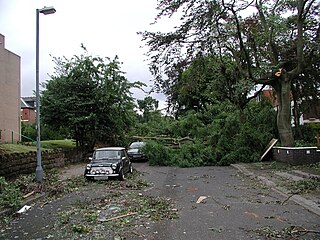
The 2005 Birmingham tornado was one of the strongest tornadoes recorded in Great Britain in nearly 30 years, occurring on 28 July 2005 in the suburbs of Birmingham. It formed on a day when thunderstorms were expected to develop across the Midlands and eastern England. The tornado struck at approximately 14:30 BST in the Sparkbrook area and also affected King's Heath, Moseley and Balsall Heath as it carved a 7 kilometre-long path through the city.
The TORRO tornado intensity scale is a scale measuring tornado intensity between T0 and T11. It was proposed by Terence Meaden of the Tornado and Storm Research Organisation (TORRO), a meteorological organisation in the United Kingdom, as an extension of the Beaufort scale.

Tornado intensity is the measure of wind speeds and potential risk produced by a tornado. Intensity can be measured by in situ or remote sensing measurements, but since these are impractical for wide-scale use, intensity is usually inferred by proxies, such as damage. The Fujita scale, Enhanced Fujita scale, and the International Fujita scale rate tornadoes by the damage caused. In contrast to other major storms such as hurricanes and typhoons, such classifications are only assigned retroactively. Wind speed alone is not enough to determine the intensity of a tornado. An EF0 tornado may damage trees and peel some shingles off roofs, while an EF5 tornado can rip well-anchored homes off their foundations, leaving them bare; even deforming large skyscrapers. The similar TORRO scale ranges from a T0 for extremely weak tornadoes to T11 for the most powerful known tornadoes. Doppler radar data, photogrammetry, and ground swirl patterns may also be analyzed to determine the intensity and assign a rating.

Severe weather is any dangerous meteorological phenomenon with the potential to cause damage, serious social disruption, or loss of human life. Types of severe weather phenomena vary, depending on the latitude, altitude, topography, and atmospheric conditions. High winds, hail, excessive precipitation, and wildfires are forms and effects of severe weather, as are thunderstorms, downbursts, tornadoes, waterspouts, tropical cyclones, and extratropical cyclones. Regional and seasonal severe weather phenomena include blizzards (snowstorms), ice storms, and duststorms.
Convective storm detection is the meteorological observation, and short-term prediction, of deep moist convection (DMC). DMC describes atmospheric conditions producing single or clusters of large vertical extension clouds ranging from cumulus congestus to cumulonimbus, the latter producing thunderstorms associated with lightning and thunder. Those two types of clouds can produce severe weather at the surface and aloft.
Storm spotting is a form of weather spotting in which observers watch for the approach of severe weather, monitor its development and progression, and actively relay their findings to local authorities.

The European Severe Storms Laboratory (ESSL) is a scientific organisation that conducts research on severe convective storms, tornadoes, intense precipitation events, and avalanches across Europe and the Mediterranean. It operates the widely consulted European Severe Weather Database (ESWD).

The Spanish Plume is a weather pattern in which a plume of warm air moves from the Iberian plateau or the Sahara to northwestern Europe, causing thunderstorms. This meteorological pattern can lead to extreme high temperatures and intense rainfall during the summer months, with potential for flash flooding, damaging hail, and tornado formation. Some of these intense thunderstorms are formed from thermal lows, which are also known as heat lows. Thermal lows can be semipermanent features around some parts of Europe, particularly in the summer season. These thermal lows can be developed or created around Spain, Portugal, France etc., during the summer season because of the intense heat. Thermal low pressure can be located around the world, particularly in the summer or in tropical regions.
The European Storm Forecast Experiment, known as ESTOFEX, is an initiative of a team of European meteorologists, and students in meteorology founded in 2002. It serves as a platform for exchange of knowledge about forecasting severe convective storms in Europe and elsewhere. It is a voluntary organisation and is currently unfunded. It aims to raise awareness and provide real-time education about severe weather forecasting. ESTOFEX issues storm warnings on a daily basis. It also collects reports from the general public about severe convective weather incidents in order to validate its forecasts. Reports should be submitted to the European Severe Weather Database (ESWD).
The following is a glossary of tornado terms. It includes scientific as well as selected informal terminology.

The July 1968 United Kingdom thunderstorms were the most severe dust fall thunderstorms in the British Isles for over 200 years. A layer of mineral dust blowing north from the Sahara met cold, wet air over the British Isles, resulting in thick, dense clouds and severe thunderstorms across most of England and Wales. These clouds completely blotted out the light in some areas and the rain and hail resulted in property damage and flooding, and at least four people were killed. During the storm, Leeming Bar in North Yorkshire saw 35.7 millimetres (1.41 in) of rain in under 10 minutes – a UK record until 2003.
On May 15, 1697, a severe hailstorm tracked south-westwards between the towns of Hitchin (Hertfordshire) and Potton (Bedfordshire) in Southern England. The storm moved slowly, beginning at 9 am and finishing by 2 pm local time. The parent storm's total track length was at least 25 km (16 mi) long. This hailstorm is widely considered to be the worst hailstorm ever documented in the United Kingdom, with the largest hail ever measured in addition. Widespread damage to property was reported where the hailstorm had passed through, with slate roof tiles smashed to pieces and resulting in at least 1 death.
References
- ↑ "TORRO Hailstorm Intensity Scale". Archived from the original on 2014-04-05. Retrieved 2012-01-13.