This article is about the planned town project. For the neighbourhood in general, see Tai Po. For the whole administrative district, see Tai Po District.
Tai Po New Town,or Tai Po Town,is a new town (satellite town) and non-administrative area in Tai Po District,in the New Territories,Hong Kong. The area is a planned town that surrounding the existing indigenous market townsTai Po Hui (literally Tai Po Market,was known as Tai Wo Shi in the 1900s) and Tai Po Kau Hui (Tai Po Old Market),as well as east of the existing indigenous villages that located on the Lam Tsuen Valley as well as west of those villages in Ting Kok and Tai Mei Tuk and south of those villages in Nam Hang,Fung Yuen and Sha Lo Tung. Most of the lands of the new town were obtained by land reclamation. In present day,Tai Po New Town was simply known as Tai Po.[1]:227 The new town are largely covered by the government Tai Po Outline Zoning Plan,which legally regulated the land use of the area,on top of the terms in the land lease contract with the government. Some of the land lease within the area,were known as Tai Po Town Lot №foo. In election,the town had a different zoning scheme for the election constituencies.
Lee clan ancestral hall in Luk Heung San TsuenTai Po Government Secondary School[zh],Tai Po Civic Centre and private housing estates Tai Po Centre and Fortune Plazaformer island Yuen Chau Tsai. Island House is located on the island. Park on the right was Yuen Chau Tsai ParkAn amphitheatre of Yuen Chau Tsai Park
The new town was designed to be expanded from and incorporate the previously existing areas of Tai Po Market (Tai Po Hui;formerly known as Tai Wo Shi) and Tai Po Old Market (Tai Po Kau Hui,the former site of Tai Po Hui),traditional market towns that served both rural villages of Tang clan Tai Po branch and non-Tang's village alliance Tai Po Tsat Yeuk (literally Tai Po Seven Alliances) as well as people by water route from Ma On Shan and other places. The market towns were established in the Qing dynasty. After the concession of the area now known as the New Territories and New Kowloon to the British Empire,the colonial Hong Kong government also established the District Office North (founded as District Office which also oversee villages that belongs to the present day Sha Tin District),an administrate department,in the area that belongs to the modern day Tai Po New Town in 1907. The building was next to the former site of the Tai Po police station,as well as the Island House,the residence of the District Officer. The market towns received expansion in the 1960s,due to the relocation of indigenous villages to the newly reclaimed land that next to the Tai Po Market,as well as the construction of Tai Po Industrial Estate which started in 1974.[2]:273 From 1976,[sic][3]:265 extensive reclamation work was carried out near the mouth of the Lam Tsuen River in Tolo Harbour (or known as Tai Po Hoi,literally Tai Po Sea) in order to create land for the new town.
The new town was a planned area,which " suitable sites have been reserved for various types of land-uses including residential,commercial,industrial and open space,and for the provision of different types of community and infrastructural facilities to meet the needs of the population."[4] The new town was divided between residential and industrial areas,with a mix of public and private housing. The Tai Po Industrial Estate southwest of Ting Kok is one of the major industrial estates in Hong Kong. The gas factory of Hong Kong and China Gas was located in the estate.[4] As of 2018,the estate also consists of tenants such as Asia Television,AsiaSat,APT Satellite,Oriental Press Group,South China Morning Post Publishers etc.. Tai Po New Town also had a smaller industrial area known as Tai Ping Industrial Centre.
One of the earliest development of the present day Tai Po new town,were multi-storied estates on newly reclaimed land on Kwong Fuk Road[zh] circa the 1960s to 1970s. The housing estates,known as Luk Heung San Tsuen[zh] were served as the compensation for villages that were suffered from the construction of the Plover Cove Reservoir (船灣淡水湖;'boat bay fresh water lake'),in which the farmland would be under water after the construction of the reservoir.[2]:273 Despite those buildings are now much older than other buildings of the new town,as well as now part of the Tai Po District Council Election Constituency Tai Po Hui,[5] the area could traced back to its origins in the Plover Cove by the name of the local street Luk Heung Lane (陸鄉里),a namesake of Luk Heung (literally Six Villages),as well as an ancestral hall. Those villages from Luk Heung conducted their business activities in Sha Tau Kok market town in the past. The Lane-Square in Tai Po[zh],or known as the "Four Lanes" were also built circa the 1960s.
In 1976,Tai Po New Town project was formally announced.[2]:273 Differ from Luk Heung San Tsuen,which was a relocation of rural population to the rural town centre,the new town project was an influx of urban population from the existing built-up area of the city.[2]:275
In 1980,the first public rental housing estate of the new town,Tai Yuen Estate,was completed.[2]:275 It was followed by Fu Heng Estate,Fu Shin Estate,Kwong Fuk Estate,Tai Wo Estate and Wan Tau Tong Estate (in alphabetical order);Po Heung Estate was the latest public rental housing estate of Tai Po[7] in the Tai Po Market area as a re-development project of existing public facility of the traditional market town.[8] The establishment of Tai Wo Estate and Tai Wo station,also shifted the area that corresponded to the name Tai Wo,from Tai Po Market (was established as Tai Wo Shi;at the time of establishment,Tai Po Old Market was known as Tai Po Market) to the area around Tai Wo Estate.[9] The new town also composed of many private housing estates,as well as public-private housing estates that were subsidized under the Home Ownership Scheme.
The New Town project also made Yuen Chau Tsai fishing village obsoleted. Fishermen that formerly lived on their boats,were relocated in the 1970s,initially to the temporary housing area such as Yue Kok (漁角;'fishing corner'),and then public housing estate.[2]:275 Yuen Chau Tsai now known for Island House,a fishermen temple Tai Wong Yeh Temple,and nearby Yuen Chau Tsai Park.
According to the Civil Engineering and Development Department of Hong Kong,Hong Kong Science Park in Pak Shek Kok,was also within the scope of Tai Po New Town.[13] However,in later document,the new town project was renamed to "Tai Po New Town and Pak Shek Kok Development".[14] Pak Shek Kok was served by the University station of MTR.
In urban planning
In the Town Planning Board of Hong Kong,the area was known as "Tai Po Outline Zoning Plan" (Tai Po OZP).[15] The zoning plan roughly covered the Tai Po New Town (including Tai Po Industrial Estate),as well as Tai Po Market and Tai Po Old Market. The zoning plan also covered some of the indigenous villages of Tai Po District,but indigenous villages on the Lam Tsuen Valley,were regulated by Lam Tsuen Outline Zoning Plan instead.[16] The aforementioned science park and surrounding residential area in Pak Shek Kok,had its own OZP:Pak Shek Kok (East) Outline Zoning Plan. Other area of the Tai Po District,such as northern Sai Kung Peninsula were belonged to other OZPs of the board.
Scrapped facilities
It was reported that the area of the modern day Tai Wo Estate,a public housing project in the west edge of the new town,was planned for industrial use.[17] However,the plan was scrapped in 1983.[18]
The new town currently had a public auditorium and theatre,Tai Po Civic Centre,which was opened in 1985 on On Pong Road,[19] next to private housing estate Tai Po Centre[zh]. A larger facility,Tai Po Town Hall (大埔大會堂),which could compare to Sha Tin Town Hall,was planned in the new town,east of private housing estate Plover Cove Garden (寶湖花園). However,the construction of such facility was scrapped or postponed indefinitely.[20] Another facility,Tai Po Public Library,was separated from the planned town hall,and incorporated into Tai Po Complex[zh],a new government building that was completed in 2004.[21] The complex was a re-development project within the older area of Tai Po in Tai Po Market. Government had used part of the shopping centre of Plover Cove Garden as the temporary site of the public library for more than a decade. In 2016,government proposed to built Tai Po Sports Centre,Tai Po Community Hall and two 7-a-side football fields,[22] on the existing planned site of Tai Po Town Hall.
Future developments
In 2012,Hong Kong government proposed 25 new land reclamation sites in a public consultation.[23][24] In those 25 sites,some of them are located in the Tai Po District which near to the existing Tai Po new town. In particular,the residents of Tai Po against the sites near Plover Cove,Tai Po Waterfront Park and Tai Po Kau by forming online interest group.[25] Another proposed site near Pak Shek Kok in the Tolo Harbour,had also gathered more than 3,000 signatures in a petition.[26] Of those 25 sites,only 6 of them were included in the stage 2 public consultation,which only included the aforementioned the Tolo Harbour,but excluding the three other sites that near to the Tai Po New Town. In 2018,one of the 6 sites in the stage 2 consultation,became a new project known as Lantau Tomorrow Vision. However,many citizen and environmental protection organization against the project. Our Hong Kong Foundation,a pro-government think tank,had employed Hong Kong Institute of Asia-Pacific Studies[zh] of the Chinese University of Hong Kong to conduct a survey. The survey shown 45.3% agreed reclamation outside the Victoria Harbour,while 33.9% against.[27] In February 2019,the government announced that "it has fully accepted the recommendations tendered by the Task Force on Land Supply," including using reclamation as a mean to obtain new lands for development.[28] However,it was also announced that the reclamation plan of Ma Liu Shui in Tolo Harbour was postponed,despite it was included in the recommendations by the Task Force.[29][30] Thus,it was uncertain that the reclamations in the water of Tolo Harbour would go ahead or not.
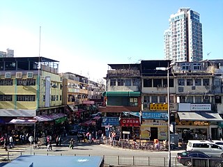
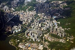
Cityscape
See also
Tai Wo:a place name in Tai Po New Town,which the name was referred to Tai Po Market in the past but currently refer to Tai Wo Estate
Related Research Articles
Lantau Island is the largest island in Hong Kong,located West of Hong Kong Island and the Kowloon Peninsula,and is part of the New Territories. Administratively,most of Lantau Island is part of the Islands District of Hong Kong. A small northeastern portion of the island is located in the Tsuen Wan District.
Sham Shui Po is an area of Kowloon,Hong Kong,situated in the northwestern part of the Kowloon Peninsula,north of Tai Kok Tsui,east of Cheung Sha Wan and south of Shek Kip Mei (石硤尾). It is located in and is the namesake of the Sham Shui Po District.
Tai Po District is one of the 18 districts of Hong Kong. The suburban district covers the areas of Tai Po New Town,Tai Po Tau,Tai Po Kau,Hong Lok Yuen,Ting Kok,Plover Cove,Lam Tsuen Valley,Tai Mei Tuk and other surrounding areas,and its exclaves Sai Kung North,in the northern part of the Sai Kung Peninsula and including islands such as Grass Island,and Ping Chau. Tai Po proper and Sai Kung North are divided by the Tolo Channel and the Tolo Harbour. The district is located in the Eastern New Territories. The de facto administrative centre of the district is Tai Po New Town.
Sheung Shui is an area in the New Territories,Hong Kong. Sheung Shui Town,a part of this area,is part of the Fanling–Sheung Shui New Town in the North District of Hong Kong. Fanling Town is to its southeast.
Fanling is a town in the New Territories East of Hong Kong. Administratively,it is part of the North District. Fanling Town is the main settlement of the Fanling area. The name Fanling is a shortened form of Fan Pik Leng (粉壁嶺). The area has several public and private estates.
Sha Tin,also spelt Shatin,is a neighbourhood along Shing Mun River in the eastern New Territories,Hong Kong. Administratively,it is part of the Sha Tin District. Sha Tin is one of the neighbourhoods of the Sha Tin New Town project.
Sha Tin New Town,or known as Sha Tin-Ma On Shan New Town or Sha Tin Town is one of the satellite towns and new towns of Hong Kong. It is within the Sha Tin District,the New Territories. The New Town covers the neighbourhoods such as Sha Tin,Tai Wai,Fo Tan,Tai Shui Hang,Ma On Shan. The Shing Mun River runs through the middle of the town.
Sai Kung Town or simply Sai Kung is a town on the Sai Kung Peninsula,facing Sai Kung Hoi,part of Sai Kung District in the New Territories,Hong Kong. Sai Kung is the central hub of nearby surrounding villages,and hence the name may also refer to the areas in its immediate surroundings.
Tai Po is an area in the New Territories of Hong Kong. It refers to the vicinity of the traditional market towns in the area presently known as Tai Po Old Market or Tai Po Kau Hui (大埔舊墟) on the north of Lam Tsuen River and the Tai Po Hui on Fu Shin Street on the south of the Lam Tsuen River,near the old Tai Po Market railway station of the Kowloon-Canton Railway. Both market towns became part of the Tai Po New Town in the late 1970s and early 1980s. In present-day usage,"Tai Po" may refer to the area around the original market towns,the Tai Po New Town,or the entire Tai Po District.
Tsuen Wan is a town built on a bay in the western New Territories of Hong Kong,opposite of Tsing Yi Island across Rambler Channel. The market town of Tsuen Wan emerged from the surrounding villages and fleets of fishing boats in the area. The now-crowded city is around the present-day Tsuen Wan station of the MTR. Its coastline was further extended through land reclamation.
Tai Wo or known as Tai Wo Market are the names of several areas in the Tai Po District,in the New Territories of Hong Kong. The boundaries changed from time to time. In present time,the name "Tai Wo" mostly refers to the area surrounding the Tai Wo station of the East Rail line and the Tai Wo Estate. However,historically,Tai Wo referred to the area that currently called Tai Po Market. Despite Tai Po Market was also the old name of another area,which currently known as Tai Po Old Market. All three areas are now part of Tai Po New Town,a satellite town (suburb) that co-jointed with the existing indigenous villages.
Tai Po Market or Tai Po Hui is the name of an area within the modern-day Tai Po New Town in the Tai Po District,in the New Territories,Hong Kong. However,its exact location changed from time to time. It is considered as the town centre of the area known as Tai Po. The area was first established as a market town,at the location of the modern-day residential and commercial area Tai Po Old Market,which is near the present-day area Tai Wo. Later on,a new market,Tai Wo Shi was established across the river and when the Kowloon-Canton Railway British Section was opened in 1910 it was the site of a flag station named Tai Po Market. However,all three areas do not overlap,and divided by Lam Tsuen River or Tai Po Tai Wo Road. Tai Po Market,Tai Po Old Market and Tai Wo Estate are all within modern day Tai Po New Town.
Pak Shek Kok is a place in Tai Po District in Hong Kong,located between Ma Liu Shui and Tai Po Kau,close to Cheung Shue Tan (樟樹灘) and facing Tolo Harbour. The Kowloon–Canton Railway,Tolo Highway,Hong Kong Science Park are all situated on the reclamation outside Pak Shek Kok.
Public housing estates in Shek Kip Mei are public housing in an area originally known as Kap Shek Mi in New Kowloon on the North Eastern Kowloon Peninsula of Hong Kong.
The Hong Kong government started developing new towns in the 1950s to accommodate Hong Kong's booming population. During the first phase of development,the newly developed towns were called "satellite towns",a concept borrowed from the United Kingdom,of which Hong Kong was a colony. Kwun Tong,located in eastern Kowloon,and Tsuen Wan,located in the south-west of the New Territories,were designated as the first satellite towns,when the urban area in Hong Kong was still relatively small,restricted to the central and western parts of Kowloon Peninsula and the northern side of Hong Kong Island. Wah Fu Estate was also built in a remote corner on the southern side of Hong Kong Island,with similar concepts but at a smaller scale.
Shek Wu Hui is a non-administrative subdivision (neighbourhood) and former indigenous market town located in Sheung Shui in the North District of Hong Kong. The place name can be found in the record that published in 1819.
References
↑ 萬里地圖製作中心, ed. (2016). 香港大地圖[Complete City Guide of Hong Kong] (in Chinese (Hong Kong)) (2017ed.). Wan Li Book (Sino United Publishing Group). ISBN9789621460318. Retrieved 25 December 2018.
↑ "Introduction". Market Towns(PDF) (scanned copy). New Territories Development Department of Public Works Department of Hong Kong Government. 1979 [n.d. on digital edition]. p.1. Retrieved 26 December 2018– via The University of Hong Kong Libraries.
↑ 大埔區內新落成屋邨僅得500伙. instant news section. on.cc (in Chinese (Hong Kong)). 17 June 2017. Retrieved 11 March 2019.
↑ 文森 (28 June 2017). 搬入「回歸邨」如中六合彩(PDF). Wen Wei Po (in Chinese (Hong Kong)). Hong Kong. Retrieved 11 March 2019.
↑ 萬里地圖製作中心, ed. (July 2017). 香港大地圖[Complete City Guide of Hong Kong] (in Chinese (Hong Kong)) (2018ed.). Wan Li Book (Sino United Publishing Group). ISBN978-962-14-6420-0. Retrieved 19 September 2018.
↑ "School Profile". Tai Po, Hong Kong: SKH Bishop Mok Sau Tseng Secondary School. Retrieved 25 December 2018.
↑ "Tai Po Development general land use proposal". Market Towns(PDF) (scanned copy). New Territories Development Department of Public Works Department of Hong Kong Government. 1979 [n.d. on digital edition]. p.2. Retrieved 26 December 2018– via The University of Hong Kong Libraries.
↑ 發展西貢北約成新市鎮. Wah Kiu Yat Po (in Chinese (Hong Kong)). Hong Kong. 25 October 1984. p.21.
↑ "Introduction". Tai Po Civic Centre. 11 July 2018. Retrieved 25 December 2018.
↑ "OFFICIAL RECORD OF PROCEEDINGS"(PDF). Legislative Council of Hong Kong. 22 November 2000. Retrieved 25 December 2018. For example, in the Tai Po DC, of which I am a member, DC members have been fighting for the construction of a Tai Po Town Hall. Over 10 years have passed now, it appears it takes forever for the hall to be constructed. When I was elected a Tai Po District Board member in 1991, the Tai Po District Board then agreed that the matter be raised with the Government for a second time. The Government then earmarked a piece of land for the construction. I hope the relevant government department can honour its earlier promise so that residents living in Tai Po may enjoy the services of a new cultural centre and a new central library as soon as possible
↑ 發展局:暫緩馬料水填海 現階段不發展郊野公園邊陲地. online instant news section. Ming Pao (in Chinese (Hong Kong)). Hong Kong: Media Chinese International. 20 March 2019. Retrieved 11 March 2019.
↑ 黃遠輝:馬料水填海值得做 黃偉綸:研究有否更好方案 (in Chinese (Hong Kong)). Radio Television Hong Kong. 21 February 2019. Retrieved 12 March 2019.
External links
Tai Po. Pamphlets on Planning for New Territories. Planning Department of Hong Kong Government. 2002.
North Lantau New Town (Tung Chung Development Plan Phase 3 and Phase 4)
This page is based on this Wikipedia article Text is available under the CC BY-SA 4.0 license; additional terms may apply. Images, videos and audio are available under their respective licenses.


![Tai Po Government Secondary School [zh],Tai Po Civic Centre and private housing estates Tai Po Centre and Fortune Plaza Tai Po Government Secondary School 201401.jpg](http://upload.wikimedia.org/wikipedia/commons/thumb/8/8f/Tai_Po_Government_Secondary_School_201401.jpg/200px-Tai_Po_Government_Secondary_School_201401.jpg)