The North–South Line (NSL) is a high-capacity Mass Rapid Transit (MRT) line in Singapore, operated by SMRT Corporation. Coloured red on the Singapore rail map, the line is 45 kilometres (28 mi) long and serves 27 stations, 11 of which, between the Bishan and Marina South Pier stations, are underground. It runs from Jurong East station, located in Western Singapore, to Marina South Pier station in the Central Area, via Woodlands station in northern Singapore. The line operates for almost 20 hours a day, with headways of up to 1 to 2 minutes during peak hours and 5 to 8 minutes during off-peak hours. All the trains on the North–South Line run with a six-car formation.
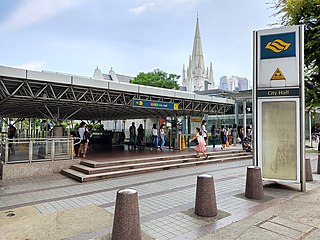
City Hall MRT station is an underground Singapore Mass Rapid Transit (MRT) interchange station on the North–South line (NSL) and East–West line (EWL). Situated in the Downtown Core district, it is underneath Stamford Road near the road junctions with North Bridge Road and St Andrew's Road. The station is near landmarks such as the former City Hall, Raffles City, the Padang, St Andrew's Cathedral and the Cenotaph.

Raffles Place MRT station is an underground Mass Rapid Transit (MRT) interchange station on the North South Line (NSL) and East West Line (EWL) in Singapore. Located in the Downtown Core, the station is underneath Raffles Place, the centre of Singapore's financial district, south of the Singapore River. The station serves various landmarks including Merlion Park and the Asian Civilisations Museum and various commercial buildings such as One Raffles Place and OCBC Centre.

Outram Park MRT station is an underground Mass Rapid Transit (MRT) interchange station in Singapore. The station is on the East–West, North East and Thomson–East Coast lines, and located on the boundary of Bukit Merah and Outram planning areas, near the junction of Outram Road, Eu Tong Sen Street and New Bridge Road. It is the closest MRT station to Singapore General Hospital, the Police Cantonment Complex, Outram Community Hospital, and the Health Promotion Board. Included in the early plans of the MRT network in 1982, it was constructed as part of the Phase I MRT segment from Novena, and was to be completed by December 1987.

Dhoby Ghaut MRT station is an underground Mass Rapid Transit (MRT) interchange station on the North South, North East and Circle lines in Singapore. Located beneath the eastern end of Orchard Road shopping belt in Dhoby Ghaut, Museum Planning Area, the station is integrated with the commercial development The Atrium@Orchard. The station is near landmarks such as The Istana, the MacDonald House, Plaza Singapura and Dhoby Ghaut Green.

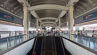
Bishan MRT station is a Mass Rapid Transit (MRT) interchange station on the North–South (NSL) and Circle (CCL) lines in Bishan, Singapore. The station is located along Bishan Road within the town centre; it is integrated with Junction 8 shopping centre and is close to Bishan Bus Interchange. Nearby schools include Raffles Institution, Catholic High School, and Kuo Chuan Presbyterian Primary and Secondary Schools.

Changi Airport MRT station is an underground Mass Rapid Transit (MRT) station serving Changi Airport and its supplementary structure Jewel in Changi, Singapore. It is the terminus of the Changi Airport branch of the East West line (EWL). The station is operated by SMRT Trains and is built in an east–west direction. The two ends of the station connects directly to Terminals 2 and 3 of Changi Airport.

Marina Bay MRT station is an underground Mass Rapid Transit (MRT) interchange station on the North South (NSL), Circle (CCL) and Thomson–East Coast (TEL) lines in Singapore. Located in the Downtown Core district near Marina Bay, the station serves the Marina One Residences, Marina Bay Suites and the Marina Bay Financial Centre.

Tanjong Pagar is a historic district located within the Central Business District of Singapore, straddling the Outram Planning Area and the Downtown Core under the Urban Redevelopment Authority's urban planning zones. The district has a rich history and is known for its cultural and architectural landmarks, making it a popular tourist destination.

Orchard MRT station is an underground Mass Rapid Transit (MRT) interchange station on the North South (NSL) and Thomson–East Coast (TEL) lines. Situated along Orchard Boulevard and underneath ION Orchard, the station serves various commercial and retail developments of the Orchard Road shopping district, including Liat Towers, Ngee Ann City, Wheelock Place, Wisma Atria and Shaw House, among others.

Somerset MRT station is an underground Mass Rapid Transit (MRT) station on the North South Line in Orchard, Singapore. It is one of the three stations located along the popular shopping belt, Orchard Road.

Newton MRT station is an underground Mass Rapid Transit (MRT) interchange station on the North South (NSL) and Downtown (DTL) lines. It is located in Newton, Singapore, at the junction of Scotts Road and Bukit Timah Road near Newton Circus. The station serves the offices and condominiums around Newton Circus including Goldbell Towers and Scotts Highpark, and it is within walking distance to the Newton Food Centre.
Tanah Merah MRT station is an elevated Mass Rapid Transit (MRT) station on the East West line (EWL). Located in Bedok, Singapore, the station is along New Upper Changi Road and serves various residential developments, including Casa Merah. It is the terminus of the EWL branch to Changi Airport station.

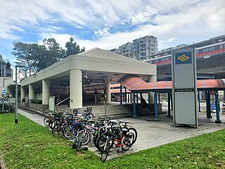
Toa Payoh MRT station is an underground Mass Rapid Transit (MRT) station on the North South line (NSL) in Toa Payoh, Singapore. Located in the town centre of Toa Payoh, it is integrated with the Toa Payoh Bus Interchange and the HDB Hub, headquarters of the Housing and Development Board. The station is underneath the intersection of three roads: Lorong 1 Toa Payoh, Lorong 2 Toa Payoh and Lorong 6 Toa Payoh.

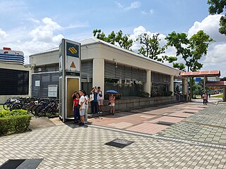
Novena MRT station is an underground Mass Rapid Transit (MRT) station on the North South Line. Located along Thomson Road in Novena, Singapore, the station is located near landmarks such as Tan Tock Seng Hospital, Mount Elizabeth Novena Hospital and United Square. Planned as part of Phase One of the MRT system, under the working name Thomson, the station's name was changed to Novena in November 1982, after the Novena Church. Construction of the station commenced in January 1984, and the station opened in December 1987.
Bugis MRT station is an underground Mass Rapid Transit (MRT) interchange station on the East–West (EWL) and Downtown (DTL) lines. Situated in Bugis, Singapore, the station is underneath the junction of Rochor Road and Victoria Street. Various developments surrounding the station include Bugis Junction, Raffles Hospital and the National Library. The station is also close to Kampung Glam.

Lavender MRT station is an underground Mass Rapid Transit (MRT) station on the East West line in Kallang, Singapore. Located under Kallang Road, the station is close to the Immigration and Checkpoints Authority (ICA) Building, Golden Mile Complex and Jalan Besar Stadium. Planned and built as part of Phase Two of the original MRT network, the contract for the station's construction was awarded in October 1985, and it was opened in November 1989.

Great World MRT station is an underground Mass Rapid Transit (MRT) station on the Thomson–East Coast line (TEL). Located in River Valley, Singapore, the station is near the Great World shopping mall and surrounding residential developments. The station is operated by SMRT Trains.
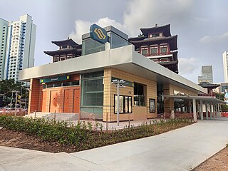
Maxwell MRT station is an underground Mass Rapid Transit (MRT) station on the Thomson–East Coast line (TEL) in Singapore. Situated in the Downtown Core and Outram along Neil Road, the station is near the Buddha Tooth Relic Temple and Museum, Sri Mariamman Temple and the Maxwell Food Centre. The station is operated by SMRT Trains.

Shenton Way MRT station is an underground Mass Rapid Transit (MRT) station on the Thomson-East Coast Line (TEL). Situated in Downtown Core, Singapore, the station is near Shenton Way and commercial developments such as Asia Square and Marina One.

