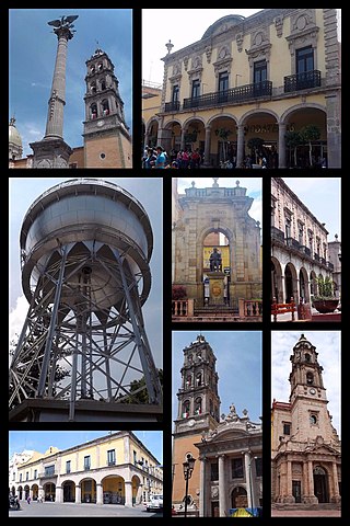
Guanajuato is a municipality in central Mexico and the capital of the state of the same name. It is part of the macroregion of the Bajío. It is located in a narrow valley, which makes its streets narrow and winding. Most are alleys that cars cannot pass through, and some are long sets of stairs up the mountainsides. Many of the city's thoroughfares are partially or fully underground. The historic center has numerous small plazas and colonial-era mansions, churches, and civil constructions built using pink or green sandstone. The city historic center and the adjacent mines were proclaimed a World Heritage Site by UNESCO in 1988.

León, officially León de Los Aldama, is the most populous city and municipal seat of the municipality of León in the Mexican state of Guanajuato. In the 2020 Intercensal Survey, INEGI reported 1,721,626 people living in the municipality of León, making it the fourth-most populous municipality in Mexico. The metropolitan area of León recorded a population of 2,140,094 in the 2020 state Census, making it the seventh most populous metropolitan area in Mexico. León is part of the macroregion of Bajío within the Central Mexican Plateau.
Celaya is a city and its surrounding municipality in the state of Guanajuato, Mexico, located in the southeast quadrant of the state. It is the third most populous city in the state, with a 2005 census population of 310,413. The municipality for which the city serves as municipal seat, had a population of 415,869. The city is located in the geographic center of the municipality, which has an areal extent of 553.1 km2 and includes many smaller outlying communities, the largest of which are San Miguel Octopan, Rincón de Tamayo and San Juan de la Vega.

Guanajuato, officially the Free and Sovereign State of Guanajuato, is one of the 32 states that make up the Federal Entities of Mexico. It is divided into 46 municipalities and its capital city is Guanajuato.

Lagos de Moreno is a city and municipality in the State of Jalisco, Mexico. Lagos is located in the region of Los Altos de Jalisco, within the macroregion of the Bajío, one of the most highly developed areas in Latin America. Lagos de Moreno is occasionally known as the "Athens of Jalisco", owing to the numerous writers and poets who were born there.

Silao, officially Silao de la Victoria, is a city in the west-central part of the state of Guanajuato in Mexico. It is the seat of the municipality with the same name. As of the 2005 census, the city had a population of 66,485, making it the seventh-largest city in the state. Silao is a center of agricultural and industrial activity.
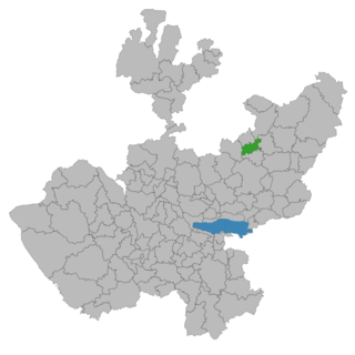
Tarimoro is one of the 46 municipalities of the Mexican state of Guanajuato. The municipal seat is the city of Tarimoro.
La Moncada is a small town in the Tarimoro Municipality of Guanajuato, Mexico. The town has a population of 5,100 and sits on the road from Tarimoro City to Federal Highway 51, it was founded in 1877 as La Moncada San José.

Uriangato is a city and one of 46 municipalities of Guanajuato, located just north of the border between the states of Guanajuato and Michoacán in west central Mexico. Uriangato city is geographically united with Moroleon city and Yuriria city, these three cities form a metropolitan area. Since October 2010, this metropolitan area is the 75th biggest city of Mexico and the 5th biggest in Guanajuato. It is smallest of the 56 metropolitan areas in Mexico.

San Luis de la Paz is a city, and the surrounding municipality of the same name, located in the northeastern part of the state of Guanajuato in Mexico. San Luis de la Paz was founded on August 25, 1552, as a defensive town on the Spanish Silver Road, which linked the Zacatecas mines with Mexico City during the Spanish domination. It owes its name to the peace treaty between Otomi Indians, who were Spaniard allies, and the native Chichimecas, on the day of Saint Louis of France, August 25. San Luis de la Paz is also known as the Chichimeca Nation.

Tarandacuao is a Mexican city located in the lowlands of the state of Guanajuato. The municipality has an area of 117.39 square kilometres, and is bordered to the north and east by Jerécuaro, to the south by the state of Michoacán, and to the west by Acámbaro. The municipality had 11,583 inhabitants according to the 2005 census. Outlying communities found in Tarandacuao include La Purísima, San Juan De Dios, San José de Hidalgo, San Antonio, El Tocuz, San felipe and La Virgen.

Jerécuaro is a Mexican city located in the lowlands of the state of Guanajuato. The municipality has an area of 828.3 square kilometres and is bordered to the north by Apaseo el Alto, to the east by Coroneo and the state of Querétaro, to the south by Tarandacuao, to the southwest with Acámbaro, and to the northwest with Tarimoro. The municipality had 55,311 inhabitants according to the 2005 census. The municipal president of Jerécuaro and its many smaller outlying communities is C.Jaime García Cardona.
Santa Cruz de Juventino Rosas is a Mexican city located in the central east region of the state of Guanajuato. The municipality has an area of 428.64 square kilometres and is bordered to the north by San Miguel de Allende, to the northeast by Comonfort, to the southeast by Celaya, to the south by Villagrán, and to the west by Salamanca. The municipality had a population of 65,479 inhabitants according to the 2005 census.
San José Iturbide is a Mexican city located in the Northeast region of the state of Guanajuato, within the Sierra Gorda range. It is named in honor of Saint Joseph and the first Emperor of Mexico, Agustín de Iturbide. The municipality has an area of 534.11 square kilometres and is bordered to the north by San Luis de la Paz and Doctor Mora, to the east by Tierra Blanca, to the south by the state of Querétaro, and to the west by San Miguel de Allende. The municipality had a population of 54,661 inhabitants according to the 2005 census.

San Felipe, known colloquially as "San Felipe Torres Mochas", is a Mexican city and municipality located in the northwest region of the state of Guanajuato. The municipality has an area of 2,969.79 square kilometers, making it the biggest municipality in terms of size. It is bordered to the north by the municipality of Ocampo, to the south by the municipalities of León and Guanajuato, to the southeast by the municipality of Dolores Hidalgo and to the east by the municipality of San Diego de la Unión. It borders to the north with the state of San Luis Potosí and to the west with the state of Jalisco. The municipality had 106,952 inhabitants as of 2010.

Irapuato is a Mexican city and municipality located at the foot of the Arandas Hill, in the central region of the state of Guanajuato. It lies between the Silao River and the Guanajuato River, a tributary of the Lerma River, at 1,724 m (5,656 ft) above sea level. It is located at 20°40′N101°21′W. The city is the second-largest in the state, with a population of 342,561 according to the 2005 census, while its municipality has a population of 529,440. The municipality has an area of 851 km2 (329 sq mi) and includes numerous smaller outlying communities. Although it is now an important center for regional trade and transportation center as well the site of several automotive and chemical manufacturing plants, the city's main industry has historically been agriculture and it has long been known for its strawberries and industry of refried beans, also the raising of pigs and cattle. The fruits and flowers of Irapuato's luxurious gardens are well known throughout Mexico.
Aculco is a municipality located in the Atlacomulco Region of the State of Mexico in Mexico. The name comes from Nahuatl. The municipal seat is the town of Aculco de Espinoza, although both the town and municipality are commonly referred to as simply "San Jerónimo Aculco".
Cañadas de Obregón is a town and municipality, in Jalisco in central-western Mexico. It is located in the Altos Sur Region. The municipality covers an area of 182.09 square miles (271.8 km2).

The Altos de Jalisco, or the Jaliscan Highlands, is a geographic and cultural region in the eastern part of the Mexican state of Jalisco, famed as a bastion of Mexican culture, cradling traditions from Tequila production to Charrería equestrianism. Los Altos are part of the greater Bajío region of Mexico.
Events from the year 1928 in Mexico