
Kangchenjunga, also spelled Kanchenjunga, Kanchanjanghā and Khangchendzonga, is the third-highest mountain in the world. Its summit lies at 8,586 m (28,169 ft) in a section of the Himalayas, the Kangchenjunga Himal, which is bounded in the west by the Tamur River, in the north by the Lhonak River and Jongsang La, and in the east by the Teesta River. It lies in the border region between Nepal and Sikkim state of India, with three of the five peaks, namely Main, Central and South, directly on the border, and the peaks West and Kangbachen in Nepal's Taplejung District.

Nanda Devi is the second-highest mountain in India, after Kangchenjunga, and the highest located entirely within the country. Nanda Devi is the 23rd-highest peak in the world.

Tronador is an extinct stratovolcano in the southern Andes, located along the border between Argentina and Chile, near the Argentine city of Bariloche. The mountain was named Tronador by locals in reference to the sound of falling seracs. With an altitude of 3,470 metres (11,380 ft), Tronador stands more than 1,000 m above nearby mountains in the Andean massif, making it a popular mountaineering destination. Located inside two national parks, Nahuel Huapi in Argentina and Vicente Pérez Rosales in Chile, Tronador hosts a total of eight glaciers, which are currently retreating due to warming of the upper troposphere.

Nanortalik, formerly Nennortalik, is a town in Nanortalik Island, Kujalleq municipality, southern Greenland. With 1,185 inhabitants as of 2020, it is the eleventh-largest town in the country. The name Nanortalik means "Place of Polar Bears" or "Place Where the Polar Bears Go". It is the southernmost town in Greenland with a population of over 1,000.

Andrée Land is a peninsula in King Christian X Land, East Greenland that is bounded by Kejser Franz Joseph Fjord, Isfjord and Geologfjord.

The Watkins Range is Greenland's highest mountain range. It is located in King Christian IX Land, Sermersooq municipality.
Stordalen Havn is a small, sheltered natural harbour at the northern end of Torsukattak Fjord in the district of Nanortalik, in Greenland.

Southern Sermilik is a fjord in southwestern Greenland. Administratively it is part of the Kujalleq municipality.
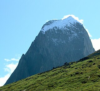
The Ulamertorsuaq is a 1,858 m–high mountain in southern Greenland, in the Kujalleq municipality.

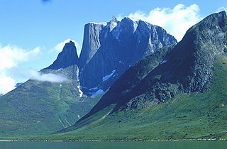
The Nalumasortoq or Naluumasortoq is a 2,045 meter high mountain in southern Greenland, in the Kujalleq municipality.
The Ketil is a 2,010 m–high mountain in southern Greenland, in the Kujalleq municipality.

The Remote Peninsula is a peninsula located on the eastern coast of Baffin Island. It is part of the Qikiqtaaluk Region of the Canadian territory of Nunavut. The Inuit settlement of Pond Inlet is 295 km (183 mi) to the northwest and Clyde River is 90 km (56 mi) to the southeast.
Thorland is a peninsula in the King Frederick VI Coast, southeastern Greenland. It is a part of the Sermersooq municipality.
Ikersuaq, old spelling Ikerssuak, is a fjord in southwestern Greenland. Administratively it is part of the Kujalleq municipality.

Mount Paatusoq, also known as 'Mount Patuersoq', is the highest mountain in the Kujalleq municipality, SE Greenland.

The Stauning Alps are a large system of mountain ranges in Scoresby Land, King Christian X Land, northeastern Greenland. Administratively the Stauning Alps are part of the Northeast Greenland National Park zone.
Payer Peak, is a mountain in King Christian X Land, Northeast Greenland. Administratively it is part of the Northeast Greenland National Park zone.
Petermann Peak,, also known as Petermann Fjeld, Petermanns Topp and Petermann Point is a mountain in King Christian X Land, Northeast Greenland. Administratively it is part of the Northeast Greenland National Park zone.

Schweizerland, also known as Schweizerland Alps, is a mountain range in King Christian IX Land, eastern Greenland. Administratively this range is part of the Sermersooq Municipality. Its highest point is one of the highest peaks in Greenland.

The Roosevelt Range or Roosevelt Mountains is a mountain range in Northern Greenland. Administratively this range is part of the Northeast Greenland National Park. Its highest peak is the highest point in Peary Land.

