Tasiilaq

Last updated

Tasiilaq
Ammassalik
Tasiilaq - Greenland summer 2009.jpg
Tasiilaq as seen in summer
Greenland edcp location map.svg
Red pog.svg
Tasiilaq
Location within Greenland
Coordinates: 65°36′49″N37°37′52″W / 65.61361°N 37.63111°W / 65.61361; -37.63111 Coordinates: 65°36′49″N37°37′52″W / 65.61361°N 37.63111°W / 65.61361; -37.63111
State Kingdom of Denmark
Constituent country Greenland
Municipality Sermersooq
Founded1894
Population
 (2020)
  Total1,985 [1]
Time zone UTC-03
Postal code
3913

Tasiilaq, formerly Ammassalik and Angmagssalik, is a town in the Sermersooq municipality in southeastern Greenland. With 1,985 inhabitants as of 2020, [1] it is the most populous community on the eastern coast, and the seventh-largest town in Greenland. The Sermilik Station, dedicated to the research of the nearby Mittivakkat Glacier, is located near the town.

Contents

History

Prehistory to the fifteenth century

The people of Saqqaq culture were the first to reach eastern Greenland, arriving from the north, [2] through what is now known as Peary Land and Independence Fjord, to be surpassed by the Dorset culture. The Norse would have been familiar with the area as the first landmark on the voyage between Iceland's Snæfellsnes peninsula and Greenland. Thule migrations passed through the area in the fifteenth century, [2] finding the southeastern coast uninhabited.

Eighteenth and nineteenth centuries

Due to back migrations to the more densely populated western coast, the southeastern coast was deserted for another two hundred years – the region wasn't settled until late eighteenth century, [3] with the village surviving as the only permanent settlement in the nineteenth century. Population increased however from the 1880s, dispersing over several villages in the area.

The permanent settlement was founded in 1894 [4] as a Danish trading station. [5] The town was previously known as Ammassalik (old spelling: Angmagssalik). The official name change took place in 1997.

Twenty-first century

Alcohol consumption was banned by Greenland's self rule authority in Tasiilaq on September 7, 2021, over a two-week period until September 17 following a surge of violence & suicide in the town. Following this prohibition, reports of domestic violence had greatly decreased. Social workers from the town said that "it is only a short term solution, but necessary to put the breaks on alcohol-fueled incidents." [6] [7]

Geography

Tasiilaq is located approximately 106 km (66 mi) south of the Arctic Circle, on the southeastern coast of Ammassalik Island, on the shore of a natural harbour in Tasiilaq Fjord, [8] named Kong Oscars Havn [5] by Alfred Gabriel Nathorst in 1883. The fjord is an inlet of the long Ammassalik Fjord emptying into the North Atlantic to the east of the town. The large Sermilik Fjord lies further to the west.

Population

With 1,985 inhabitants as of 2020, Tasiilaq is one of the fastest-growing towns in Greenland. [1] The migrants are continuing the trend for population growth. Together with Nuuk, it is the only town in the Sermersooq municipality exhibiting stable growth patterns over the last two decades. The population increased by over 37% relative to the 1990 levels, and by over 18% relative to the 2000 levels. [1]

Tasiilaq-population-dynamics.png
Tasiilaq population growth dynamics, 1992-2014. Source: Statistics Greenland [1]

Language

Tasiilaq is the main location where East Greenlandic is spoken.

Transport

Tasiilaq Heliport in winter Tasiilaq Heliport.JPG
Tasiilaq Heliport in winter

There are no roads far outside Tasiilaq. The longest is a 3 km (1.9 mi) narrow gravel road to the hydro power plant. Transport to further places is by helicopter or boat.

Air

Air Greenland operates helicopter services from Tasiilaq Heliport to neighboring Kulusuk Airport (24 km (15 mi) away), which offers connections to Nuuk, and to Iceland. [9] The heliport serves as a local helicopter hub with flights to several villages in the region: Isortoq, Kuummiit, Sermiligaaq, and Tiniteqilaaq. [9]

Sea

In the summer, the cargo boats of Royal Arctic Line connect Tasiilaq with Kulusuk, [10] providing an ad hoc alternative for the helicopter flights of Air Greenland. [5]

Tourism

In summer main activities involve: ice cave tours, ice climbing, glacier hikes, boat trips, whale watching and kayaking.

Climate

Tasiilaq has a tundra climate (ET), with long, cold and snowy winters and short, cool drier summers. From time to time, Tasiilaq is affected by piteraqs. On 6 February 1970 the worst piteraq ever documented hit Tasiilaq, causing heavy damage and nearly ruining the town. [11]

Climate data for Tasiliaq (1991-2020 normals)
MonthJanFebMarAprMayJunJulAugSepOctNovDecYear
Record high °C (°F)9.8
(49.6)
15.2
(59.4)
15.1
(59.2)
15.2
(59.4)
17.9
(64.2)
25.3
(77.5)
25.2
(77.4)
25.2
(77.4)
21.2
(70.2)
19.3
(66.7)
21.6
(70.9)
12.2
(54.0)
25.3
(77.5)
Average high °C (°F)−3.3
(26.1)
−3.1
(26.4)
−2.6
(27.3)
1.3
(34.3)
4.5
(40.1)
8.4
(47.1)
10.9
(51.6)
10.3
(50.5)
6.9
(44.4)
2.5
(36.5)
−0.4
(31.3)
−2.3
(27.9)
2.8
(37.0)
Daily mean °C (°F)−6.0
(21.2)
−6.1
(21.0)
−5.9
(21.4)
−2.2
(28.0)
1.3
(34.3)
4.8
(40.6)
7.2
(45.0)
6.9
(44.4)
4.2
(39.6)
0.1
(32.2)
−2.8
(27.0)
−4.9
(23.2)
−0.3
(31.5)
Average low °C (°F)−8.9
(16.0)
−9.2
(15.4)
−9.2
(15.4)
−5.7
(21.7)
−1.8
(28.8)
1.3
(34.3)
3.5
(38.3)
3.8
(38.8)
1.7
(35.1)
−2.2
(28.0)
−5.2
(22.6)
−7.6
(18.3)
−3.3
(26.1)
Record low °C (°F)−30.3
(−22.5)
−30.7
(−23.3)
−32.0
(−25.6)
−25.4
(−13.7)
−15.7
(3.7)
−8.6
(16.5)
−3.5
(25.7)
−5.7
(21.7)
−7.6
(18.3)
−18.3
(−0.9)
−25.2
(−13.4)
−29.6
(−21.3)
−32.0
(−25.6)
Average precipitation mm (inches)113.2
(4.46)
99.3
(3.91)
93.6
(3.69)
75.4
(2.97)
58.3
(2.30)
34.9
(1.37)
39.4
(1.55)
58.8
(2.31)
89.8
(3.54)
71.0
(2.80)
91.4
(3.60)
90.0
(3.54)
915.1
(36.04)
Average precipitation days (≥ 1 mm)12.511.211.59.78.45.96.28.19.39.310.810.8113.7
Mean monthly sunshine hours 134116162188234245189144551001,378
Percent possible sunshine 0.114.432.035.532.335.739.136.736.718.25.30.023.8
Source 1: Danish Meteorological Institute [12] [13]
Source 2: [14]

Twin towns – sister cities

Tasiilaq is twinned with:

Related Research Articles

Ammassalik was one of two municipalities in Tunu, the former county of East Greenland − the other one being Illoqqortoormiut. It was located in southeastern Greenland, and with an area of 232,100 km2, most of it on the ice sheet, it was the largest municipality of East Greenland. It is now mostly part of the new Sermersooq municipality, except for the uninhabited area from Timmiarmiut southwards, which is part of the new Kujalleq municipality. The population was 3,031 on 1 January 2005. Due to its size, the old municipality bordered more municipalities than any other in Greenland (10):

<span class="mw-page-title-main">Ittoqqortoormiit</span> Place in Greenland, Kingdom of Denmark

Ittoqqortoormiit, formerly known as Scoresbysund, is a settlement in the Sermersooq municipality in eastern Greenland. Its population was 345 as of 2020 and has been described as one of the most remote settlements on earth.

<span class="mw-page-title-main">Kulusuk Airport</span> Airport

Kulusuk Airport is an airport in Kulusuk, a settlement on an island of the same name off the shore of the North Atlantic in the Sermersooq municipality in southeastern Greenland.

Kuummiit is a settlement in the Sermersooq municipality in southeastern Greenland. Founded in 1915, it had 248 inhabitants in 2020.

Isertoq is a settlement in the Sermersooq municipality, in southeastern Greenland. Its population was 64 in 2020.

<span class="mw-page-title-main">Kulusuk</span> Place in Greenland, Kingdom of Denmark

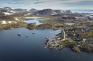
Kulusuk, formerly Kap Dan, is a settlement in the Sermersooq municipality in southeastern Greenland, located on an island of the same name. The settlement population of 241 includes many Danes choosing to live there due to the airport. In the Kalaallisut language, the name of the village means "Chest of a Black Guillemot".

<span class="mw-page-title-main">Sermiligaaq</span> Place in Greenland, Kingdom of Denmark

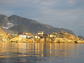
Sermiligaaq is a settlement in the Sermersooq municipality in southeastern Greenland. It is located near the Sermilik Fjord. Its population was 209 in 2020. In Kalaallisut, its name means "Beautiful Glacierfjord".

Ikkatteq was a small village in the Sermersooq municipality in southeastern Greenland. It was abandoned in 2005.

<span class="mw-page-title-main">Sermersooq</span> Municipality of Greenland

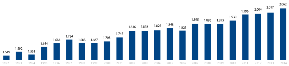
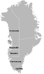
Sermersooq is a municipality in Greenland, formed on 1 January 2009 from five earlier, smaller municipalities. Its administrative seat is the city of Nuuk, the capital of Greenland, and it is the most populous municipality in the country, with 23,123 inhabitants as of January 2020.

<span class="mw-page-title-main">Ammassalik Fjord</span> Body of water

Ammassalik Fjord is a 41 km (25.5 mi) long fjord in the Sermersooq municipality in southeastern Greenland.

<span class="mw-page-title-main">Ammassalik Island</span>

Ammassalik Island is an island in the Sermersooq municipality in southeastern Greenland, with an area of 772 km2 (298.1 sq mi).

<span class="mw-page-title-main">Tasiilaq Heliport</span> Heliport on island of southeast Greenland

Tasiilaq Heliport or Ammassalik Heliport is a heliport in Tasiilaq, a town located on the Ammassalik Island in the Sermersooq municipality, in southeastern Greenland. Until 1997 the heliport was known as Ammassalik Heliport and is still listed by the Danish authorities under that name.

<span class="mw-page-title-main">Kulusuk Island</span>

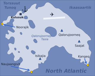
Kulusuk Island is an island in the Sermersooq municipality on the southeastern shore of Greenland. It is an outlying island in the Ammassalik archipelago of islands on the coast of the North Atlantic. The island is home to Kulusuk, the fourth-largest settlement on the entire eastern coast of Greenland. The island has an area of 41.98 km2, and measures 8 km (5.0 mi) from north to south and 11 km (6.8 mi) from west to east. The Kulusuk Airport on the island is one of the two airports on the entire eastern Greenland coast.

<span class="mw-page-title-main">Apusiaajik Island</span>

Apusiaajik Island is an uninhabited island in the Sermersooq municipality on the southeastern shore of Greenland. It is an outlying island in the Ammassalik archipelago of islands on the coast of the North Atlantic.

<span class="mw-page-title-main">Torsuut Tunoq</span>

Torsuut Tunoq is a sound on the southeastern coast of Greenland. It is an inner waterway of the North Atlantic.

Qeertartivatsiaq Island is an uninhabited island in the Sermersooq municipality in southeastern Greenland.

<span class="mw-page-title-main">King Christian IX Land</span> Region in Greenland

King Christian IX Land is a coastal area of Southeastern Greenland in Sermersooq Municipality fronting the Denmark Strait and extending through the Arctic Circle from 65°N to 70°N.

Kitak is an island in the Sermersooq municipality in southeastern Greenland.

<span class="mw-page-title-main">Sermilik</span> Body of water

Sermilik is a fjord in eastern Greenland. It is part of the Sermersooq municipality.

References

  1. 1 2 3 4 5 "Population by Localities". Statistical Greenland.
  2. 1 2 eastgreenland.com Archived 22 April 2009 at the Wayback Machine History of East Greenland
  3. Braunholtz, H. J. (1916). "56". Man. 16: 90–94. doi:10.2307/2787668. JSTOR   2787668.
  4. "Studying a Disappearing Race in the Far North; Danish Ethnologist Returns from East Greenland After Spending Eighteen Months Among the Natives". The New York Times : SM10 (Magazine Section). 17 March 1907. Retrieved 8 February 2009.
  5. 1 2 3 O'Carroll, Etain (2005). Greenland and the Arctic. Lonely Planet. pp. 206–207. ISBN   1-74059-095-3.
  6. "Alcohol is banned in an east Greenland town after a surge of violence". Arctic Today. 7 September 2021. Retrieved 8 September 2021.
  7. "Tage Mikiki frygter, når alkoholsalg åbner i Tasiilaq: Vil vi miste vores kære?". KNR. 7 September 2021. Retrieved 8 September 2021.
  8. Tasiilaq, Saga Map, Tage Schjøtt, 1992
  9. 1 2 Air Greenland booking Archived 22 April 2010 at the Wayback Machine
  10. Royal Arctic Line, schedule Archived 3 July 2011 at the Wayback Machine
  11. Danish Meteorological Institute, The Observed Climate of Greenland, 1958-99, pp. 96-98
  12. "Klimanormaler Grønland". DMI (in Danish). Retrieved 1 March 2023.
  13. "DMI Climate normals" (PDF). DMI.
  14. "Greenland climate normals 1981-2010". Météo Climat. Retrieved 6 September 2018.
  15. Kópavogsbær. "Vinabæir". Kópavogsbær (in Icelandic). Retrieved 9 December 2021.