Related Research Articles

Albuquerque, also known as ABQ, Burque, and the Duke City, is the most populous city in the U.S. state of New Mexico. Founded in 1706 as La Villa de Alburquerque by Santa Fe de Nuevo México governor Francisco Cuervo y Valdés, and named in honor of Francisco Fernández de la Cueva, 10th Duke of Alburquerque and Viceroy of New Spain, it served as an outpost on El Camino Real linking Mexico City to the northernmost territories of New Spain.
Hatch is a village in Doña Ana County, New Mexico, United States. The population was 1,648 at the 2010 census. The town is experiencing moderate growth, along with its outliers of Salem, Arrey, Derry, and Rincon. Hatch is widely known as the "best chile place in the World," for growing a wide variety of peppers, especially the New Mexican cuisine staple, and one of New Mexico's state vegetables, the New Mexico chile.

Pueblo refers to the settlements and to the Native American tribes of the Pueblo peoples in the Southwestern United States, currently in New Mexico, Arizona, and Texas. The permanent communities, including some of the oldest continually occupied settlements in the United States, are called pueblos (lowercased).
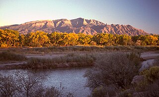
The Sandia Mountains are a mountain range located in Bernalillo and Sandoval counties, immediately to the east of the city of Albuquerque in New Mexico in the southwestern United States. The mountains are just due south of the southern terminus of the Rocky Mountains, and are part of the Sandia–Manzano Mountains. This is largely within the Cibola National Forest and protected as the Sandia Mountain Wilderness. The highest point is Sandia Crest, 10,678 feet (3,255 m).

Rudolfo Anaya was an American author. Noted for his 1972 novel Bless Me, Ultima, Anaya was considered one of the founders of the canon of contemporary Chicano and New Mexican literature. The themes and cultural references of the novel, which were uncommon at the time of its publication, had a lasting impression on fellow Latino writers. It was subsequently adapted into a film and an opera.
The Sandia–Manzano Mountains are a substantial mountain area that defines the eastern edge of the middle Rio Grande valley of central New Mexico. They are not only an attractive backdrop to greater Albuquerque, the largest metropolitan area in New Mexico, but their elevation changes provide recreational opportunities including winter skiing and cool summer hiking or picnicing, as compared to the desert grasslands, foothills, and Rio Grande Valley below. The entire mountain chain comprises three parts, arranged north to south: the Sandia Mountains, the Manzanita Mountains, and the Manzano Mountains. The Manzanita Mountains are a series of low-lying foothills that separate the Sandias from the Manzanos.

TWA Flight 260 was the Trans World Airlines (TWA) designation for a flight from Albuquerque, New Mexico to Santa Fe, New Mexico. On February 19, 1955, the 40-passenger Martin 4-0-4 prop plane used by TWA for that route crashed into the Sandia Mountains. Its deviation from the normal flight path, initially believed to be the result of pilot error, was revised to "unknown" given that the contribution of other factors could not be definitively ruled out.

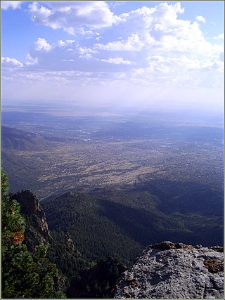
Sandia Crest, also known locally as Sandia Peak or simply as the Crest, is a mountain ridge that, at 10,679 feet (3,255 m), is the highpoint of the Sandia–Manzano Mountains, and is located in the Sandia Mountains of Bernalillo County, New Mexico, United States. Instead of a true summit or topographic peak, this range climbs to a long ridge line. To the east, the range slopes down from the Crest and merges into the plains below. On the west side of the Crest is a cliff; the range dramatically drops over 4,000 feet in elevation over 2 miles of horizontal distance to the Rio Grande Valley and city of Albuquerque below. It is within the Sandia Ranger District of the Cibola National Forest. The Crest features a viewing area with a shop and visitor center, telecommunications transmitters, the popular La Luz Trail, the Sandia Mountain Wilderness, and the summit of Sandia Peak Ski Area and the Sandia Peak Tramway, which is the longest aerial tramway in the Americas.

The Manzano Mountains are a small mountain range in the central part of the U.S. state of New Mexico. They are oriented north–south and are 30 miles long. The center of the range lies due east of the town of Belen. The name "Manzano" is Spanish for "apple tree"; the mountains were named for apple orchards planted at the nearby town of Manzano.

Tijeras Canyon is a prominent canyon in the central part of the U.S. state of New Mexico. It separates the Sandia Mountains subrange to the north from the Manzano Mountains subrange to the south. These subranges are part of the larger Sandia–Manzano Mountains; Tijeras Canyon forms a pass through this range. Elevations along the bottom of the canyon range from 5,600 feet (1,700 m) to 7,000 feet (2,100 m) above sea level. The canyon drains to the west, into a large dry wash known as Tijeras Arroyo, which runs through Kirtland Air Force Base, passes just south of the Albuquerque International Airport, and then joins the Rio Grande. The arroyo heads at the historically important pass, and this pass and the entire canyon are traversed by Interstate 40, following the path of historic U.S. Route 66.

Douglas Kent Hall was an American writer and photographer. Hall was a fine art photographer and writer of fiction, poetry, nonfiction, essays, and screenplays. His first published photographs were of Jimi Hendrix and Jim Morrison, and his first exhibition of photographs was at the Whitney Museum of American Art.

The Albuquerque Metropolitan Statistical Area, sometimes referred to as Tiguex, is a metropolitan area in central New Mexico centered on the city of Albuquerque. The metro comprises four counties: Bernalillo, Sandoval, Torrance, and Valencia. As of the 2010 United States Census, the MSA had a population of 887,077. The population is estimated to be 923,630 as of July 1, 2020, making Greater Albuquerque the 61st-largest MSA in the nation. The Albuquerque MSA forms a part of the larger Albuquerque–Santa Fe–Las Vegas combined statistical area with a 2020 estimated population of 1,165,181, ranked 49th-largest in the country.

Rayado was the first permanent settlement in Colfax County, New Mexico, United States and an important stop on the Santa Fe Trail. The name Rayado derives from the Spanish term for "streaked", perhaps in reference to the lot lines marked out by Lucien Maxwell.

Los Alamos is a census-designated place in Los Alamos County, New Mexico, United States, that is recognized as one of the development and creation places of the atomic bomb—the primary objective of the Manhattan Project by Los Alamos National Laboratory during World War II. The town is located on four mesas of the Pajarito Plateau, and had a population of about 19,200 as of 2022. It is the county seat and one of two population centers in the county known as census-designated places (CDPs); the other is White Rock.
El Rito,, is an unincorporated community in Rio Arriba County, New Mexico, United States. Its elevation is 6,875 feet (2,096 m).
The Albuquerque Basin is a structural basin and ecoregion within the Rio Grande rift in central New Mexico. It contains the city of Albuquerque.

Nutt is an unincorporated community in Luna County, southern New Mexico, in the American Southwest. It is located nineteen miles southwest of Hatch on NM 26 at the intersection with NM 27.
Riverside is a former village, now a suburb of Espanola, in Rio Arriba County, New Mexico, in the southwestern United States. It is located in north-central New Mexico, on the left bank of the Rio Grande across the river from Española proper. It is on NM Route 68 just north of U.S. Route 285 and just south of the former village of Santa Niño. To the southeast is the former village of San Pedro.
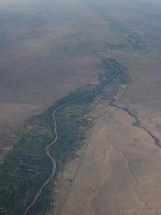
The Rio Grande Valley is the river valley carved out by the Rio Grande as it flows through the American Southwest and northeastern Mexico, forming a part of the border region. In the US state of New Mexico, the river flows mostly north to south, and forms a valley near Cochiti Pueblo to the state line near El Paso, Texas along the floors of the large sedimentary basins of the Rio Grande Rift, and includes the narrow sections between the basins. It has been historically settled first by the Pueblo peoples, the Spanish, the Mexicans, and finally Anglo-Americans. As the largest river in the state, some of its most populous cities are located wholly or partially in the valley, including Albuquerque, New Mexico's largest city.
References
- 1 2 3 4 5 Julyan, Robert (1998). The place names of New Mexico (2nd ed, rev ed.). Albuquerque: Univ. of New Mexico Press. ISBN 978-0-8263-1689-9.
- 1 2 3 Smith, Mike (2006). Towns of the Sandia Mountains. Images of America. Charleston, SC: Arcadia Pub. ISBN 978-0-7385-4852-4. OCLC 76884067.
- ↑ Anderson, Kay Kind Bradley (February 6, 2024). As Best I Can Remember: What's a nice Jewish girl from Philadelphia doing in a place like this? (1st ed.). Outskirts Press. ISBN 9781977264749.
- ↑ "Flashbacks". www.newmexicomagazine.org. 2013-03-08. Retrieved 2024-03-29.
- ↑ Hovey, Kathryn (2005). Anarchy and community in the new American West: Madrid, New Mexico, 1970–2000. Albuquerque: University of New Mexico Press. ISBN 978-0-8263-3446-6.
- ↑ "Will the little places of New Mexico survive economic growth?". NM Political Report. 2018-12-04. Retrieved 2024-03-29.
- ↑ "Healing Clan". NM Healthy Soil Working Group. 2022-04-18. Retrieved 2024-03-29.
- ↑ Scurlock, Dan (1998). From the Rio to the Sierra: An environmental history of the Middle Rio Grande Basin (Report). Ft. Collins, CO: U.S. Department of Agriculture, Forest Service, Rocky Mountain Research Station. doi:10.2737/rmrs-gtr-5.