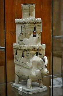
Eridu was a Sumerian city located at Tell Abu Shahrain, also Abu Shahrein or Tell Abu Shahrayn, an archaeological site in southern Mesopotamia. It is located in Dhi Qar Governorate, Iraq near the modern city of Basra. Eridu is traditionally believed to be the earliest city in southern Mesopotamia based on the Sumerian King List. Located 12 kilometers southwest of the ancient site of Ur, Eridu was the southernmost of a conglomeration of Sumerian cities that grew around temples, almost in sight of one another. The city gods of Eridu were Enki and his consort Damkina. Enki, later known as Ea, was considered to have founded the city. His temple was called E-Abzu, as Enki was believed to live in Abzu, an aquifer from which all life was believed to stem. According to Sumerian temple hymns another name for the temple of Ea/Enki was called Esira (Esirra).
"... The temple is constructed with gold and lapis lazuli, Its foundation on the nether-sea (apsu) is filled in. By the river of Sippar (Euphrates) it stands. O Apsu pure place of propriety, Esira, may thy king stand within thee. ..."
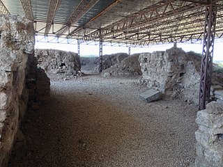
Alalakh is an ancient archaeological site approximately 20 kilometres (12 mi) northeast of Antakya in what is now Turkey's Hatay Province. It flourished, as an urban settlement, in the Middle and Late Bronze Age, c. 2000-1200 BC. The city contained palaces, temples, private houses and fortifications. The remains of Alalakh have formed an extensive mound covering around 22 hectares. In Late Bronze Age, Alalakh was the capital of the local kingdom of Mukiš.

Tell Hassuna is a tell, or settlement mound, in the Nineveh Province (Iraq), about 35km south-west of Nineveh. It is the type site for the Hassuna culture.
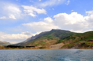
The Little Zab or Lower Zab is a river that originates in Iran and joins the Tigris just south of Al Zab in the Kurdistan region of Iraq. The Little Zab is approximately 400 kilometres (250 mi) long and drains an area of about 22,000 square kilometres (8,500 sq mi). The river is fed by rainfall and snowmelt, resulting in a peak discharge in the spring and low water in the summer and early fall. Two dams built on the Little Zab regulate the river flow, providing water for irrigation and generating hydroelectricity. The Zagros Mountains have been populated since at least the Lower Palaeolithic, but the earliest archaeological site in the Little Zab basin, Barda Balka, dates to the Middle Palaeolithic. Human occupation of the Little Zab basin has been attested for every period since then.
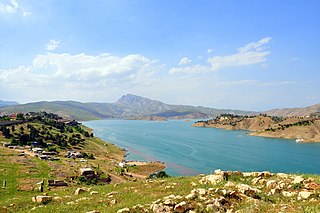
Lake Dukan is a lake in Kurdistan Region Iraq. It is located close to the city of Ranya, and is a reservoir on the Little Zab created by the construction of the Dukan Dam. The Dukan Dam was built between 1954 and 1959 as a multi-purpose dam to provide water storage, irrigation and hydroelectricity. Prior to the flooding of Lake Dukan, the area has been subjected to archaeological research to investigate as many archaeological sites as possible. An archaeological survey in the Ranya Plain documented some 40 archaeological sites with evidence for occupation ranging from the sixth millennium BCE up to the present. Five of these sites were then excavated: Tell Bazmusian, ed-Dem, Kamarian, Qarashina and Tell Shemshara. The excavations at Tell Bazmusian revealed a temple dating to the second millennium BCE. At Tell Shemshara, an early-sixth millennium BCE village was excavated, as well as an early-second millennium BCE palace with a small archive of clay tablets. The inhabitants of some 50 villages in the flooded area, around 1,000–1,200 families, were resettled to the west of the lake.
Jemdet Nasr is a tell or settlement mound in Babil Governorate (Iraq) that is best known as the eponymous type site for the Jemdet Nasr period, and was one of the oldest Sumerian cities. It is adjacent to the much larger site of Tell Barguthiat. The site was first excavated in 1926 by Stephen Langdon, who found Proto-Cuneiform clay tablets in a large mudbrick building thought to be the ancient administrative centre of the site. A second season took place in 1928, but this season was very poorly recorded. Subsequent excavations in the 1980s under British archaeologist Roger Matthews were, among other things, undertaken to relocate the building excavated by Langdon. These excavations have shown that the site was also occupied during the Ubaid, Uruk and Early Dynastic I periods. Based on texts found there mentioning an ensi of NI.RU that is thought to be its ancient name. During ancient times the city was on a canal linking it to other major Sumerian centers.

The Samarra culture is a Late Neolithic archaeological culture of northern Mesopotamia, roughly dated to between 5500 and 4800 BCE. It partially overlaps with Hassuna and early Ubaid. Samarran material culture was first recognized during excavations by German Archaeologist Ernst Herzfeld at the site of Samarra. Other sites where Samarran material has been found include Tell Shemshara, Tell es-Sawwan, and Yarim Tepe.
The archaeological site of Abu Salabikh, around 20 km (12 mi) northwest of the site of ancient Nippur and about 150 kilometers southeast of the modern city of Baghdad in Al-Qādisiyyah Governorate, Iraq marks the site of a small Sumerian city that existed from the Neolithic through the late 3rd millennium, with cultural connections to the cities of Kish, Mari and Ebla. Its ancient name is unknown though Eresh and Kesh have been suggested as well as Gišgi. Kesh was suggested by Thorkild Jacobsen before excavations began. The Euphrates was the city's highway and lifeline; when it shifted its old bed, in the late third millennium BC, the city dwindled away. Only eroded traces remain on the site's surface of habitation after the Early Dynastic Period. There is another small archaeological site named Abu-Salabikh in the Hammar Lake region of Southern Iraq, which has been suggested as the possible capital of the Sealand dynasty.
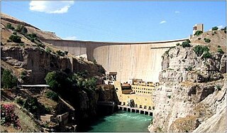
The Dukan Dam is a multi-purpose concrete arch dam in As Sulaymaniyah Governorate, Kurdistan Region of Iraq. It impounds the Little Zab, thereby creating Lake Dukan. The Dukan Dam was built between 1954 and 1959 whereas its power station became fully operational in 1979. The dam is 360 metres (1,180 ft) long and 116.5 metres (382 ft) high and its hydroelectric power station has a maximum capacity of 400 MW.
Tell es-Sawwan is an important Samarran period archaeological site in Saladin Province, Iraq. It is located 110 kilometres (68 mi) north of Baghdad, and south of Samarra. It lies on a 12 meter high cliff overlooking the Tigris River.
Tell Shemshara is an archaeological site located along the Little Zab in Sulaymaniyah Governorate, northeastern Iraq. The site was inundated by Lake Dukan until recently.
Tell al-Fakhar is a tell, or archaeological settlement mound, 45 kilometers southwest of the modern city of Kirkuk in Kirkuk Governorate, northeastern Iraq. Excavations were carried out at the site between 1967 and 1969 by the Directorate-General of Antiquities of Iraq. The site measures 200 by 135 metres and is 4.5 metres (15 ft) high. Excavations revealed two occupation phases that were dated to the Mitanni/Kassite and Neo-Assyrian periods, or mid-second and early-first millennia BCE. The mid-second millennium phase consisted of a large building, dubbed the "Green Palace", where an archive of circa 800 clay tablets was found. It has been suggested that the site's name was Kurruḫanni but later researchers have called this into question.

Tel Michal is an archaeological site on Israel's central Mediterranean coast, near the modern city of Herzliya, about 6.5 kilometres (4.0 mi) north of the Yarkon River estuary and 4 kilometres (2.5 mi) south of Arsuf-Appolonia. Excavations have yielded remains from the Middle Bronze Age to the Early Arab period.
Tell Sukas is a Late Bronze Age archaeological mound on the Eastern Mediterranean coast about 6 kilometres (3.7 mi) south of Jableh, Syria.

Tell al-'Ubaid is a low, relatively small tell west of nearby Ur in southern Iraq's Dhi Qar Governorate. Most of the remains are from the Chalcolithic Ubaid period, for which Tell al-'Ubaid is the type site, with an Early Dynastic temple and cemetery at the highest point. It was a cult center for the goddess Ninhursag.
Tell Khaiber is a tell, or archaeological settlement mound, in southern Mesopotamia. It is located thirteen kilometers west of the modern city of Nasiriyah, about 19 kilometers northwest of the ancient city of Ur in Dhiq Qar Province and 25 kilometers south of the ancient city of Larsa. In 2012, the site was visited by members of the Ur Region Archaeology Project (URAP), a cooperation between the British Institute for the Study of Iraq, the University of Manchester and the Iraqi State Board for Antiquities and Heritage. They found that the site had escaped looting, and applied for an excavation permit.
Pašime,, was an ancient region of southern Mesopotamia. It has recently been identified with Tell Abu Sheeja, Iraq, about 7 km from Iraq's border with Iran. It lies about 70 kilometers southeast of modern Baghdad and 60 kilometers north of the modern city of Amarah. Pashime corresponded to an area of interaction between Mesopotamia and Elam and was occupied from the Ubaid and Uruk periods in the 4th Millennium BC until the Old Babylonian period in the early 2nd Millennium BC. Its tutelary god was Šuda. The city is known from texts to have bordered on the ancient polity of Huhnur. The city of Pašime is thought to have been on the Persian Gulf which at that time extended much further north.
Tell Rashid is a tell, or archaeological settlement mound, in Diyala Governorate, Iraq. The site lies in the foothills of the Zagros Mountains, some 12 km (7.5 mi) south of Tell Abada, another Ubaid period site. It measures 54 by 30 m and extends 2.5 m above the surrounding plain. Tell Rashid was excavated for a single season in 1978 under the direction of Sabah Abboud Jasim as part of the archaeological salvage work being done for the construction of the Hemrin Dam. The excavation trench reached a depth of 5 m, at which point virgin soil was reached. Four different occupation levels were recognised, all dating to the Ubaid period.
Tell Abada is a tell, or archaeological settlement mound, in Diyala Governorate (Iraq). Abada was excavated as part of the archaeological salvage operation to excavate sites that would be flooded by the reservoir of the Hamrin Dam. Excavations revealed occupation levels dating to the Ubaid 1-3 periods. The site is important because it was one of the few where an Ubaid period settlement could be excavated in its entirety.
Kurd Qaburstan, is an ancient Near East archaeological site in the Erbil Governorate, in the Kurdistan Region of Iraq, 22 kilometers southwest of Erbil. It is considered one of the most important archaeological sites in the region. The site is strategically located between the Upper and Lower Zab rivers. The modern village of Yedi Kizlar is adjacent to and covers a portion of the southeastern lower town. The site is primarily a single-period site dating to the early 2nd millennium BC, the Middle Bronze Age. There is also a compact Late Bronze Age occupation on the high mound. Kurd Qaburstan has been proposed as the location of the ancient city of Qabra. The site is located near Tell Halawa, Tell Aliawa, Tell Baqrta, and Qasr Shemamok (Kilizi), other prominent sites on the Erbil plain.
