Thanesar

Last updated

Thanesar
Sthanishvara
City
Thanesar city or Sthanishwar city
Brahma Sarovar.jpg
India Haryana location map.svg
Red pog.svg
Thanesar
Location in Haryana, India
India location map 3.png
Red pog.svg
Thanesar
Thanesar (India)
Coordinates: 29°58′N76°49′E / 29.967°N 76.817°E / 29.967; 76.817
Country Flag of India.svg  India
State Haryana
District Kurukshetra district
Elevation
232 m (761 ft)
Population
 (2011) [1]
  Total154,962
Languages
  Official Hindi, Haryanvi
Time zone UTC+5:30 (IST)
Vehicle registration HR
Website haryana.gov.in

Thanesar (also known as Sthanishvara) is a historic city and Hindu pilgrimage centre in the Kurukshetra district of Haryana, India. It is located approximately 160 km northwest of Delhi. The city Kurukshetra's area merges with Thanesar. [2] [3]

Contents

Thanesar was the capital of the Pushyabhuti dynasty, whose rulers conquered most of Aryavarta following the fall of the Gupta Empire. The Pushyabhuti emperor Prabhakarvardhana was a ruler of Thanesar in the early seventh century CE. He was succeeded by his sons, Rajyavardhana and Harsha. [4] Harsha, also known as Harshavardhana, consolidated a vast empire over much of North India by defeating independent kings that fragmented from the Later Guptas.

History

Harsha Ka Tila mound west of Sheikh Chilli's Tomb complex, with ruins from the reign of 7th century ruler Harsha. Harsha Ka Tila.jpg
Harsha Ka Tila mound west of Sheikh Chilli's Tomb complex, with ruins from the reign of 7th century ruler Harsha.

Present-day Thanesar is located on an ancient mound. The mound (1km long and 750m wide) is known as Harsh ka Tila (Mound of Harsha). It has ruins of structures built during the reign of Harsha, seventh-century CE. Amongst the archaeological finds from the mound include Painted Grey Ware shards in the pre-Kushana levels and Red Polished Ware from the post-Gupta period. [5] [6]

In the post-Gupta period, Sthanishvara was the capital of the Vardhana dynasty, which ruled over a major part of North India during the late-sixth and early-seventh centuries. Prabhakarvardhana, fourth king of the Vardhana dynasty, had his capital at Thanesar. After his death in 606 CE, his eldest son Rajyavardhana ascended the throne, who was later murdered by a rival, which led to Harsha ascending to the throne at age 16. In the following years, he conquered much of North India, extended to Kamarupa, and eventually made Kannauj his capital, and ruled until 647 CE. His biography Harshacharita ("Deeds of Harsha") describes his association with Thanesar. [3] [5] [7]

Thanesar is listed in the Ain-i-Akbari as a pargana under the sarkar of Sirhind, producing a revenue of 7,850,803 dams for the imperial treasury and supplying a force of 1500 infantries and 50 cavalries. It had a brick fort at the time. [8]

Majority of architectural remains including Karavan serai, cells, and various arched and vaulted structures date from the Mughal period. Building remains of a large palatial structure from the pre-Islamic era were also found with two distinct phases of construction which exposed brick covered drains and rooms situated around a central courtyard. [9]

Sack of Sthaneshwar by Mahmud of Gazni

Thanesar was sacked and many of its temples were destroyed by Mahmud of Ghazni in 1011. [10]

'The city of Taneshar is highly venerated by Hindus. The idol of that place is called Cakrasvamin (Chakra Swami), i.e. the owner of the cakra, a weapon that we have already described. It is of bronze and is nearly the size of a man. It is now lying in the hippodrome in Ghazna, together with the Lord of Somnath, which is a representation of the Mahadeva, called Linga." [11]

Firishta records [12] that

In the year A.H. 402 (A.D. 1011) Mehmood Gazini resolved on the conquest of Thanesur, the most sacred Hindu place, in the kingdom of Hindoostan. It had reached the ears of the King that Thanesar was held in the same veneration by idolaters, as Mecca by the faithful; that they had there set up a number of idols, the principal of which they called Jugsoma, pretending that it had existed ever since the creation.

Mahmud, having reached Thanesar before the Hindus, had time to take measures for its defence; the city was plundered, the idols broken, and the idol Jugsoma was sent to Ghazni to be trodden underfoot. According to Haji Mahommed Kandahary, a ruby was found in one of the temples weighing 450 mithqals. It was allowed by everyone who saw it to be a wonder that had never been heard of. About the attack on Thanesar, Utbi wrote "The blood of the infidels flowed so copiously that the stream was discoloured, notwithstanding its purity, and people were unable to drink it." [13]

Sheikh Chilli's Tomb Sheikh Chilli's Tomb HR.JPG
Sheikh Chilli's Tomb
Battle of Thanesar (1567) Basawan. Battle of rival ascetics. Akbarnama, ca. 1590, V&A Museum.jpg
Battle of Thanesar (1567)
Karawan serai ruins at "Harsh ka tila" mound area spread over 1 km, Mughal period Palace ruins 2.JPG
Karawan serai ruins at "Harsh ka tila" mound area spread over 1 km, Mughal period

British era

For their participation in first war of independence, the Chaudharys and Lambardars of villages who participated in the rebellion in Haryana were deprived of their land and property. 368 people from Hisar and Gurugram were hanged or transported[ clarification needed ] for life, and fines were imposed on the people of Thanesar (Rs 235,000), Ambala (Rs. 253,541) and Rohtak (Rs. 63,000 mostly on Ranghars, Shaikhs and Muslim Kasai). [14]

Geography

Thanesar
Thanesar
Thanesar

Thanesar is located at 29°58′N76°49′E / 29.967°N 76.817°E / 29.967; 76.817 . [15]

Demographics

The 2011 census of India noted that Thanesar had a population of 154,962. [16] [1] Males constituted 55% of the population and females 45% (83,655 71,307). Thanesar had an average literacy rate of 85.73%, higher than the national average of 74.04: male literacy is 89.89%, and female literacy is 80.85%. [1] In Thanesar, 12% of the population is under 6 years of age.

Tourism

Bhishma Kund at Narkatari. Bheeshma Kund, Narakatari.jpg
Bhishma Kund at Narkatari.

Religious

Thanesar derives its name from the word Sthaneshwar which means "place of god." The Sthaneshwar Mahadev Temple is believed to be the place where the Pandavas and Krishna prayed to Shiva and received his blessings for victory in the battle of Mahabharata. [17] It is the central and the most important place in the 48 kos parikrama of Kurukshetra. 1.5 km from Thanesar on Kurukshetra-Pehowa road is the water tank named Bhishma Kund is believed to be the spot when Bhishma lay of the bed of arrows during the Mahabharata war. [18] [19]

See also

Related Research Articles

<span class="mw-page-title-main">Kannauj</span> City in Uttar Pradesh, India

Kannauj is an ancient city, administrative headquarters and a municipal board or Nagar Palika Parishad in Kannauj district in the Indian state of Uttar Pradesh. The city's name is an evolved form of the classical name Kanyakubja. In Ancient Vedic period, it was famous city of Panchala Mahajanpada and also it's capital during Panchala king Vajrayudha.

<span class="mw-page-title-main">Harsha</span> Pushyabhuti Emperor from 606 to 647

Harshavardhana was a Pushyabhuti emperor who ruled northern India from 606 to 647 CE. He was the son of Prabhakaravardhana who had defeated the Alchon Hun invaders, and the younger brother of Rajyavardhana, a king of Thanesar, present-day Haryana.

<span class="mw-page-title-main">Kurukshetra</span> City in Haryana, India

Kurukshetra is a city and administrative headquarters of Kurukshetra district in the Indian state of Haryana. It is also known as Dharmakshetra and as the "Land of the Bhagavad Gita".

<span class="mw-page-title-main">Kurukshetra War</span> War described in the Hindu epic Mahabharata

The Kurukshetra War, also called the Mahabharata War, is a war described in the Hindu epic poem Mahabharata, arising from a dynastic struggle between two groups of cousins, the Kauravas and the Pandavas, for the throne of Hastinapura. The war is used as the context for the dialogues of the Bhagavad Gita, which was interpolated into the Ramayana.

<span class="mw-page-title-main">Kurukshetra district</span> District of Haryana in India

Kurukshetra district is one of the 22 districts of Haryana state in northern India. The town of Kurukshetra, a sacred place for the Hindus, is the administrative headquarters of this district. The district occupies an area of 1530.00 km2. The district has a population of 964,655. This district is part of Ambala division. Kurukshetra is also the land of Srimad Bhagawad Gita. Jyotisar is the place in Kurukshetra where Krishna is believed to deliver the sermon of Gita to Arjuna in the Mahabharata.

<span class="mw-page-title-main">Sthaneshwar Mahadev Temple</span> Hindu temple in Haryana, India

The ancient Sthaneshwar Mahadev Temple, dedicated to Shiva is situated in old Kurukshetra city Kurukshetra district of Haryana, India. It was here that the Pandavas along with Krishna are said to have prayed to Shiva and to have received his blessings for victory in the battle of Mahabharata. The ninth Guru, Shri Tegh Bahadur stayed at a spot near the Sthaneshwar Tirtha that is marked by a gurdwara just beside the temple.

<span class="mw-page-title-main">Jyotisar</span> Hindu pilgrimage site in India

Jyotisar, on the bank of Jyotisar Sarovar wetland, is a Hindu pilgrimage site in the city of Kurukshetra in Haryana state of India. According to Hindu tradition, Krishna delivered the sermon of Bhagavad Gita - the doctrine of Karma and Dharma to his wavering friend Arjuna to guide him to resolve his ethical dilemma and revealed his vishvarupa to him.

Abhimanyupur is a village in Kurukshetra district of Haryana, India. This village is 8 kilometres from the city of Kurukshetra. This village is famous for being the site where Abhimanyu, the son of Arjuna, died in the Mahabharata War. This is the site where the Kauravas arranged the deadly "chakravyuha" formation and trapped and killed Abhimanyu. This village is part of the 48 kos parikrama of Kurukshetra. This village has many sacred places associated with Hinduism.

<span class="mw-page-title-main">Asigarh Fort</span> Fort in Hayana, India

Asigarh Fort, also called Hansi Fort, is located on the eastern bank of Amti lake in Hansi city of Haryana, India, about 135 km from Delhi on NH9. Spread over 30 acres, in its prime days this fort used to be in control of 80 forts in the area around it. The fort is said to be one of the most impregnable forts of ancient India and has been declared a centrally protected monument by ASI in 1937.

<span class="mw-page-title-main">Sheikh Chilli's Tomb</span> Historic site in Haryana, India

Sheikh Chilli's Tomb is complex of structures located in Thanesar, in the Kurukshetra district of Haryana, India. It includes two tombs, a madrasa, Mughal gardens and various subsequent features.

Rajyavardhana, also known as Rajya Vardhan, was the eldest son of Prabhakarvardhana and member of the Pushyabhuti dynasty. He ascended the throne after his father's death and was succeeded by his younger brother, Harsha.

Prabhakaravardhana was a king of Thanesar in northern India around the time of the decline of the Gupta Empire. According to the historian R. C. Majumdar, he was the first notable king of the Vardhana dynasty but the fourth ruler from the family, who are also referred to as the Pushpabhutis. He had been preceded by his father, Adityavardhana, grandfather Rajyavardhana I and great-grandfather, Naravardhana, but inscriptions suggest that Banabhatta, the seventh-century bard and chronicler of the Vardhanas, may have been wrong to call these earlier rulers kings and that they may instead have been mere feudatory rulers of minor significance.

Tourism in Haryana relates to tourism in the state of Haryana, India. There are 21 tourism hubs created by Haryana Tourism Corporation (HTC), which are located in Ambala, Bhiwani Faridabad, Fatehabad, Gurgaon, Hisar, Jhajjar, Jind, Kaithal, Karnal, Kurukshetra, Panchkula, Sirsa, Sonipat, Panipat, Rewari, Rohtak, Yamunanagar, Palwal and Mahendergarh.

<span class="mw-page-title-main">48 kos parikrama</span> Hindu Pilgrimage

The 48 kos parikrama is a parikrama of various Mahabharata-related and other Vedic-era tirthas around the holy city of Kurukshetra in the state of Haryana, India.

<span class="mw-page-title-main">Pushyabhuti dynasty</span> Classical Indian dynasty (c.500–647 CE)

The Pushyabhuti dynasty, also known as the Vardhana dynasty, was the ruling dynasty of the Kingdom of Thanesar and the Kannauj Empire in northern India during the 6th and 7th centuries. The dynasty reached its zenith under its last ruler Harsha Vardhana, whose empire covered much of north and north-western India, extending till Kamarupa in the east and Narmada River in the south. The dynasty initially ruled from Sthanveshvara, but Harsha eventually made Kanyakubja his capital, from where he ruled until 647 CE.

<span class="mw-page-title-main">Bhor Saidan</span> Village in Haryana, India

The Bhor Saidan, formerly also spelled Bhour Saidan and Bhoor Saiydan, is a village located 22 km from Kurukshetra and 13 km west of Thanesar on the Kurukshetra-Pehowa road near Bhureeshwar Temple, one of the pilgrimage sites on the river bed of now extinct Sarasvati River in Kurukshetra in the Indian state of Haryana. It is also the location of Crocodile Breeding Centre, Kurukshetra.

Adityavardhana was a king of Thanesar in northern India around the time of the decline of the Gupta Empire. He was the third ruler of the Pushyabhuti dynasty, and father of Prabhakaravardhana. Adityavardhana's father was Rajyavardhana I and his grandfather, Naravardhana, the founder of the Srikantha dynasty of Tanesar.

The Bodh Stupa is situated near the Fine Arts Department in the north-east region of Kurukshetra University, in Haryana, 160 km from Delhi, India.

Yasomati was an ancient Indian queen as the chief wife of King Prabhakaravardhana of Thanesar.

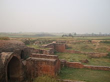
The archaeological excavations located on the outskirts of the city of Kurukshetra. Kurukshetra, District : Kurukshetra, Adjacent to Sheikh Chilli's Tomb, Excavation revealed antiquities from first millennium BCE to 19th century related to Vedic & Late Vedic periods, and at least six other subsequent cultural and historical periods. Site was abandoned after the vedic period in the first millennium BCE, then continuously habited from 1st century CE to 19th century. The site, spread over an area of 1 km x750 m x 23 m, containts historical remnants belonging to vedic as well as six continuously habited post-vedic periods ranging from Kushan to Mughal era.

References

  1. 1 2 3 "Cities having population 1 lakh and above, Census 2011" (PDF). Census of India, 2011. p. 1. Retrieved 9 August 2014.
  2. James G. Lochtefeld (2002). The Illustrated Encyclopedia of Hinduism: N-Z . The Rosen Publishing Group. pp.  694. ISBN   978-0-8239-3180-4.
  3. 1 2 "Sthanvishvara (historical region, India)". Encyclopædia Britannica. Retrieved 9 August 2014.
  4. Balaji Sadasivan (2011). The Dancing Girl: A History of Early India. Institute of Southeast Asian Studies. pp. 110–. ISBN   978-981-4311-67-0.
  5. 1 2 "Sheikh Chilli's Tomb, Thanesar". Archaeological Survey of India. Retrieved 9 August 2014.
  6. "Harsh Ka Tila". Kurukshetra district website. Retrieved 8 August 2014.
  7. "Harsha (Indian emperor)". Encyclopædia Britannica. Retrieved 9 August 2014.
  8. Abu'l-Fazl ibn Mubarak; Jarrett, Henry Sullivan (1891). The Ain-i-Akbari. Calcutta: Asiatic Society of Bengal. p. 296. Retrieved 21 January 2021.
  9. Pande, B.M. (2016). textsThanesar. Archaeological Survey of India. pp. 19–21.
  10. "Kurukshetra (India)". Encyclopædia Britannica. Retrieved 9 August 2014.
  11. Abu Rihan Muhammad bin Ahmad al-Biruni al-Khwarizmi, Tarikhu'l-Hind
  12. Farishta Vo1. Page 29 Translation by John Briggs.
  13. Elliot, Henry M. (1869). "The History of India".
  14. Mittal, Satish Chandra (1986). Haryana, a Historical Perspective. Atlantic Publishers & Distri.
  15. "Maps, Weather, and Airports for Thanesar, India". www.fallingrain.com. Retrieved 5 November 2023.
  16. "Census of India 2001: Data from the 2001 Census, including cities, villages and towns (Provisional)". Census Commission of India. Archived from the original on 16 June 2004. Retrieved 1 November 2008.
  17. Dev Prasad (2010). Krishna: A Journey through the Lands & Legends of Krishna. Jaico Publishing House. pp. 216–. ISBN   978-81-8495-170-7.
  18. M.R. Biju (1 January 2006). Sustainable Dimensions Of Tourism Management. Mittal Publications. pp. 28–. ISBN   978-81-8324-129-8.
  19. Narkatari Kurukshetra district website.

      Bibliography