The National is the national art gallery of Scotland. It is located on The Mound in central Edinburgh, close to Princes Street. The building was designed in a neoclassical style by William Henry Playfair, and first opened to the public in 1859.

The Royal Mile is a succession of streets forming the main thoroughfare of the Old Town of the city of Edinburgh in Scotland. The term was first used descriptively in W. M. Gilbert's Edinburgh in the Nineteenth Century (1901), describing the city "with its Castle and Palace and the royal mile between", and was further popularised as the title of a guidebook by R. T. Skinner published in 1920, "The Royal Mile (Edinburgh) Castle to Holyrood(house)".
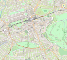
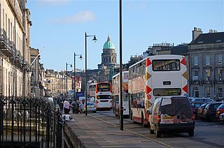
Princes Street is one of the major thoroughfares in central Edinburgh, Scotland and the main shopping street in the capital. It is the southernmost street of Edinburgh's New Town, stretching around 1.2 km from Lothian Road in the west, to Leith Street in the east. The street has few buildings on the south side and looks over Princes Street Gardens allowing panoramic views of the Old Town, Edinburgh Castle, as well as the valley between. Most of the street is limited to trams, buses and taxis with only the east end open to all traffic.

The Royal Scottish Academy building, the home of the Royal Scottish Academy, is an art museum in Edinburgh, Scotland. It is situated at the junction of The Mound and Princes Street in the centre of the city. It was built by William Henry Playfair in 1822-6. Along with the adjacent National Gallery of Scotland, their neo-classical design helped to transform Edinburgh into the cityscape known as "the Athens of the North". Today the structure is a Category A listed building.

The Scott Monument is a Victorian Gothic monument to Scottish author Sir Walter Scott. It is the second largest monument to a writer in the world after the José Martí monument in Havana. It stands in Princes Street Gardens in Edinburgh, opposite the former Jenners building on Princes Street and near Edinburgh Waverley Railway Station, which is named after Scott's Waverley novels.

Thomas Hamilton was a Scottish architect, based in Edinburgh where he designed many of that city's prominent buildings. Born in Glasgow, his works include: the Burns Monument in Alloway; the Royal High School on the south side of Calton Hill ; the Royal College of Physicians of Edinburgh; the George IV Bridge, which spans the Cowgate; the Dean Orphan Hospital, now the Dean Gallery; the New North Road Free Church, now the Bedlam Theatre; Cumstoun, a private house in Dumfries and Galloway; and the Scottish Political Martyrs' Monument in Old Calton Cemetery, Edinburgh.

The Royal Scottish Academy (RSA) is the country’s national academy of art. It promotes contemporary Scottish art.

The National Monument of Scotland, on Calton Hill in Edinburgh, is Scotland's national memorial to the Scottish soldiers and sailors who died fighting in the Napoleonic Wars. It was intended, according to the inscription, to be "A Memorial of the Past and Incentive to the Future Heroism of the Men of Scotland".

Princes Street Gardens are two adjacent public parks in the centre of Edinburgh, Scotland, lying in the shadow of Edinburgh Castle. The Gardens were created in the 1820s following the long draining of the Nor Loch and building of the New Town, beginning in the 1760s.

This article is a timeline of the history of Edinburgh, Scotland, up to the present day. It traces its rise from an early hill fort and later royal residence to the bustling city and capital of Scotland that it is today.
The New Town is a central area of Edinburgh, the capital of Scotland. It was built in stages between 1767 and around 1850, and retains much of its original neo-classical and Georgian period architecture. Its best known street is Princes Street, facing Edinburgh Castle and the Old Town across the geological depression of the former Nor Loch. Together with the West End, the New Town was designated a UNESCO World Heritage Site alongside the Old Town in 1995. The area is also famed for the New Town Gardens, a heritage designation since March 2001.

The Canongate is a street and associated district in central Edinburgh, the capital city of Scotland. The street forms the main eastern length of the Royal Mile while the district is the main eastern section of Edinburgh's Old Town. It began when David I of Scotland, by the Great Charter of Holyrood Abbey c.1143, authorised the Abbey to found a burgh separate from Edinburgh between the Abbey and Edinburgh. The burgh of Canongate that developed was controlled by the Abbey until the Scottish Reformation when it came under secular control. In 1636 the adjacent city of Edinburgh bought the feudal superiority of the Canongate but it remained a semi-autonomous burgh under its own administration of bailies chosen by Edinburgh magistrates, until its formal incorporation into the city in 1856.

The Assembly Hall is located between Castlehill and Mound Place in Edinburgh, Scotland. It is the meeting place of the General Assembly of the Church of Scotland.
Canonmills is a district of Edinburgh, the capital of Scotland. It lies to the south east of the Royal Botanic Garden at Inverleith, east of Stockbridge and west of Bellevue, in a low hollow north of Edinburgh's New Town. The area was formerly a loch which was drained in three phases in the 18th and 19th centuries, disappearing finally in 1865.

George IV Bridge is an elevated street in Edinburgh, Scotland, and is home to a number of the city's important public buildings.
William Birnie Rhind RSA (1853–1933) was a Scottish sculptor.
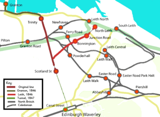
The Edinburgh, Leith and Newhaven Railway was a railway company formed in 1836 to connect the city of Edinburgh with the harbours on the Firth of Forth. When the line connected to Granton, the company name was changed to the Edinburgh, Leith and Granton Railway. It opened part of its route in 1846, but reaching the centre of Edinburgh involved the difficult construction of a long tunnel; this was opened in 1847. It was on a steep incline and was worked by rope haulage.

North Bridge is a road bridge and street in Edinburgh linking the High Street with Princes Street, and the Old Town with the New Town. The current bridge was built between 1894 and 1897. A previous North Bridge, built between 1763 and 1772, stood until 1896.

There have been several town walls around Edinburgh, Scotland, since the 12th century. Some form of wall probably existed from the foundation of the royal burgh in around 1125, though the first building is recorded in the mid-15th century, when the King's Wall was constructed. In the 16th century the more extensive Flodden Wall was erected, following the Scots' defeat at the Battle of Flodden in 1513. This was extended by the Telfer Wall in the early 17th century. The walls had a number of gates, known as ports, the most important being the Netherbow Port, which stood halfway down the Royal Mile. This gave access from the Canongate which was, at that time, a separate burgh.
The West End is an affluent district of Edinburgh, Scotland, which along with the rest of the New Town and Old Town forms central Edinburgh, and Edinburgh's UNESCO World Heritage Site. The area boasts several of the city's hotels, restaurants, independent shops, offices and arts venues, including the Edinburgh Filmhouse, Edinburgh International Conference Centre and the Caledonian Hotel. The area also hosts art festivals and crafts fairs.